Lighthouses of Romania

A nation of southeastern Europe, Romania (România in Romanian) has roughly 250 km (150 mi) of coastline on the northwestern side of the Black Sea. The southern half of the coastline has the country's major port, Constanţa, with its satellite ports Mangalia and Midia. The northern half is occupied mostly by the large delta of the Danube River.

Romania became independent in 1878 after several centuries of control by the Ottoman (Turkish) Empire. The old lighthouse of Sulina, at the mouth of the Danube, is the only lighthouse surviving from the Ottoman period. In recent years Romania has built three very tall modern lighthouses, at Sulina, Constanţa, and Mangalia.

Romania is divided into 41 counties (județe) but only two face the Black Sea. The counties are divided into municipalities and rural districts called communes (comună).

The Romanian word for a lighthouse is far or farul (plural faruri). In Romanian insulă is an island, capul is a cape, golf is a gulf or bay, râu is a river, gura is the mouth of a river, and port is a port or harbor. In Romanian the Danube is called the Dunărea and the Black Sea is the Marea Neagră.

Aids to navigation are maintained by the Romanian Navy's Maritime Hydrographic Directorate (Direcția Hidrografică Maritimă).

ARLHS numbers are from the ARLHS World List of Lights. Admiralty numbers are from volume N of the Admiralty List of Lights & Fog Signals (prior to 2013 the lights were in volume E with the same numbers). U.S. NGA List numbers are from Publication 113.

General Sources
Direcția Hidrografică Maritimă
Pages for the major lighthouses are posted under Compartimente: Semnalizare Maritimă.
Online List of Lights - Romania
Photos by various photographers posted by Alexander Trabas. Many of the photos for Romania are by Eckhard Meyer.
Lighthouses in Romania
Photos by various photographers available from Wikimedia.
World of Lighthouses - Romania
Photos by various photographers available from Lightphotos.net.
Europäische Leuchttürme auf historischen Postkarten
Historic postcard images posted by Klaus Huelse.
Navionics Charts
Navigation chart for Romania.

Farul Genovez
1886 Constanţa Light (Farul Genovez), July 2007
Wikimedia public domain photo by Kdanv

Tulcea County (Danube Delta) Lighthouses

The Danube Delta is Europe's second largest delta (after the Volga Delta). There are three main distributaries or branches. The Chilia Branch, on the north, carries more than half the flow of the river and forms the boundary between Romania and Ukraine. The Sulina Branch, in the center, is the shortest and the only branch improved for navigation by large ships. The Sfântu Gheorghe (St. George) Branch is on the southern edge of the delta.

Sulina Town Lighthouses
Sulina is a town of about 4000 residents on the south bank of the Sulina Branch just above the mouth of the river.
Sulina (2) (Sulina Main)
1983 (station established 1856). Active; focal plane 49 m (161 ft); three white flashes every 16.2 s. 48 m (157 ft) round concrete tower with lantern and two enclosed observation and control levels, rising from a triangular 2-story administration building. The tower is unpainted light gray concrete; lantern painted red. Iulian Bilauschi has a good photo and a closeup of the top of the tower, Wikimedia has a photo, Trabas has a closeup photo, Vasile Govor has a 2021 photo, and Google has a satellite view. This large tower serves as the entrance control station for ships arriving at the mouth of the Danube. It is built on a triangular artificial island attached near the end of the south breakwater at the river entrance. Accessible only by boat. Site and tower closed. ARLHS ROM-008; Admiralty N5034; NGA 17744.
Sulina Entrance South
Date unknown. Active (charted by Navionics); focal plane about 12 m (39 ft); white light, pattern unknown. Light mounted on a 3-story building. Doina Luca's 2021 photo identifies the building as a weather station (Statia meteo). Google has a sea view and a satellite view. Located on the south breakwater near its base. Site and tower closed. Not listed by the Admiralty.
Sulina North Pier
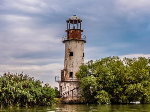
1887. Inactive. 14 m (46 ft) tapered round masonry tower with lantern and two galleries, mounted on a round stone base. Lighthouse painted white, lantern red. A photo by Valentin Manus is at right, Claudiu Presecan has a 2006 photo, Mihaela Rit has a 2015 photo, a third photo is available, Wikimedia has photos, and Google has a 2018 sea view and a satellite view. Gravely endangered: this abandoned lighthouse is in very poor condition. Located on what remains of the old north pier at Sulina. Accessible only by boat. Site open; nothing prevents visitors from climbing the tower, although this is clearly dangerous. . ARLHS ROM-018.
Sulina South Pier
1887. Inactive. 12 m (39 ft) hexagonal cast iron skeletal tower with lantern and gallery. Originally the tower was painted white and the lantern dome black. Petru Schiopu has a 2007 photo, Google has a 2018 sea view, and Bing has a satellite view. Gravely endangered: this abandoned lighthouse is in very poor condition (even worse than the North Pier Light). When Javier Ortuño Garcia visited in July 2019 he found the tower in advanced decay; the lantern dome had fallen. Located on the old south pier at Sulina, now about 2.5 km (1.5 mi) west of the actual mouth of the river. Site open, although accessibility is unknown; tower closed. ARLHS ROM-020.

Sulina North Pier Light, Sulina, March 2019
Wikimedia Creative Commons photo by ValentinManus
**** Sulina (1)
1856 (Ottoman). Inactive since 1922. 16 m (59 ft) round stone tower with lantern and gallery, attached to a 1-story masonry keeper's house. Lighthouse painted white. A 1st order Fresnel lens is mounted in the lantern. A 2021 photo is at right, Wikimedia has a 2009 closeup and additional photos, Bianca Naumovici has a good closeup, Huelse has a historic postcard view, Google has a street view, and Bing has a satellite view. The Sulina Branch of the Danube is the only mouth navigable by modern ships. Sedimentation has moved the entrance to the river considerably to the east, leaving this historic lighthouse high and dry. The lighthouse now includes a small maritime museum. In November 2017 the European Union announced a grant of €2.2 million to restore the lighthouse. As a result the lighthouse is now named the Farul Comisiei Europene a Dunării de la Sulina (European Commission on the Danube Lighthouse in Sulina). The 2021 Instagram photo at right shows the restored lighthouse. Located on the south bank of the river in the town of Sulina. Site open, tower open daily for climbing. . ARLHS ROM-019.

Sfântu Gheorghe Commune Lighthouses
* Sfântu Gheorghe (Sfintu Gheorghe, Gura Sf. Gheorghe) (2)
1968 (station established by the Ottoman Empire in 1865). Active; focal plane 48 m (157 ft); two white flashes every 7.2 s. 50 m (164 ft) triangular concrete tower with lantern. Most of the tower is white concrete; the segment on the the seaward side and the lantern are covered with gray glass. Trabas has a photo, Petru Hertescu has a photo, and Google has a street view and a satellite view. The Sfântu Georghe (St. George) Branch is the southernmost of the main mouths of the Danube River. The original lighthouse stood on the other side of the river until it was burned by arsonists in 1980; the Fresnel lens from that lighthouse is preserved at the Romanian Naval Museum (Muzeul Marinei Române) in Constanţa. Located on the north side of the river in the village of Sfântu Gheorghe. Site open, tower closed. ARLHS ROM-007; Admiralty N5032; NGA 17740.
Gura Portiţei
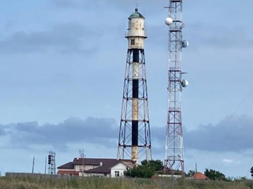
1944. Active; focal plane 22 m (72 ft); white flash every 9 s. 22 m (72 ft) square pyramidal skeletal tower with a large round lantern. Lighthouse painted with black and white horizontal bands, lantern painted white. Mihai Bruma has a 2018 photo and Google has a satellite view. Sibling of the 1942 Capul Midia lighthouse (next entry). The light station is built on a barrier beach that encloses the large Lake Razelm (or Razim) lagoon on the south side of the Danube entrances. The pass into the lagoon has closed, but the barrier is sometimes breached during storms. The lighthouse has been moved twice, in 1966 and in 1977, in search of a safer location. Located about 50 km (30 mi) northeast of Constanţa and a similar distance southwest of Sfântu Gheorghe. Site status unknown. ARLHS ROM-012; Admiralty N5031; NGA 17736


1856 Farul Sulina, Sulina, September 2021
Instagram photo by DisvoveRomania tourism agency

Constanţa County Lighthouses

Corbu Commune (Capul Midia) Lighthouse
Capul (Cape) Midia is a headland at the extreme southern end of the Danube Delta, about 20 km (13 mi) north of Constanţa. An artificial harbor has been constructed south of the cape as a satellite to the Port of Constanţa.
Midia Main (Capul Midia)
1942. Active; focal plane 36 m (118 ft); white flash every 5 s. 22 m (72 ft) skeletal tower with a large round lantern. Lighthouse painted with red and white horizontal bands, lantern is gray. Trabas has Meyer's photo and Google has a satellite view and a distant street view. Located on the headland of the cape, a short distance north of Midia Harbor. Site status unknown. ARLHS ROM-001; Admiralty N5030; NGA 17732.

Năvodari Town (Midia Harbor) Lighthouses
Midia Entrance (East Breakwater)
1989. Active; focal plane 25 m (82 ft); white light, 1.5 s on, 3.5 s off. 18 m (59 ft) concrete tower with a modern, all-glass lantern and gallery. Catalin Dragomirescu has a closeup 2021 photo, Gabriel Cioc has a photo, Martin Michalik has a distant street view, Trabas has Meyer's distant view, and Google has a satellite view. Located at the end of the east breakwater. Site and tower closed. Admiralty N5030.2; NGA 17733.
Midia East Breakwater Spur
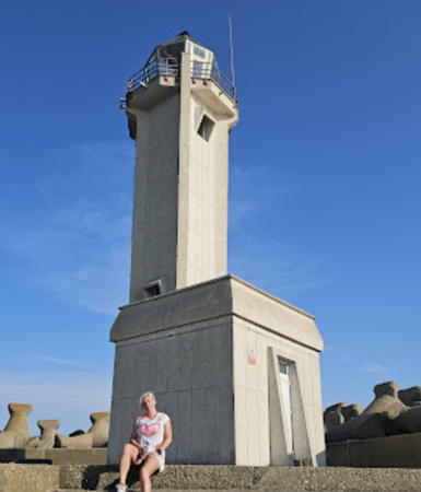
1989. Active; focal plane 14 m (46 ft); green flash every 5 s. 2-story concrete building with a lantern on the roof. Sergiu Pruteanu's photo is at right (this is the lighthouse in the background), Trabas has Meyer's distant view and Google has a satellite view. Located at the end of a short spur off the east breakwater at Midia, opposite the west breakwater light. Site and tower closed. Admiralty N5030.5.
Midia West (South) Breakwater
1989. Active; focal plane 14 m (46 ft); red flash every 5 s. 2-story concrete building with a lantern on the roof. The lighthouse is in the foreground of Sergiu Pruteanu's photo is at right, Martin Michalik has a street view, Trabas has Meyer's distant view, and Google has a satellite view. Located at the end of the west breakwater at Midia. Site and tower closed. Admiralty N5030.3.
Midia Breakwater Lights
Midia West Breakwater (foreground) and East Breakwater Spur Lights, September 2007
ex-Panoramio photo copyright Sergiu Pruteanu; permission requested

Constanţa City Lighthouses
Founded as the Greek settlement of Tomis around 600 BC, Constanţa is a city of about 300,000 residents. It has the largest port on the Black Sea.
* #Tomis Northeast Breakwater (1)
Date unknown. Active; focal plane 10 m (33 ft); green flash every 3 s. This was an 8.5 m (28 ft) round iron lantern and gallery supported by five iron posts and painted green. It has been replaced by a light on a mast. A 2006 photo of the original lighthouse is available, Trabas has Meyer's photo of the new light, a 2023 photo is available, and Google has a street view and a satellite view. The Tomis small craft harbor adjoins downtown Constanţa on the north side of the Casino area. Located at the end of the northeast breakwater of Tomis harbor. Accessible by walking the breakwater. Site open, tower closed. ARLHS ROM-022. Active light: Admiralty N5028; NGA 17728.
* #Tomis Southeast Breakwater (1)
Date unknown. Active; focal plane 10 m (33 ft); red flash every 3 s. This was an 8.5 m (28 ft) round iron lantern and gallery supported by five iron posts and painted red. It has been replaced by a light on a red mast. A 2006 photo of the original lighthouse is available, Trabas has Meyer's photo of the new light, Dan Iacomi has a 2020 photo, and Google has a street view and a satellite view. Located at the end of the southeast breakwater of Tomis harbor. Accessible by walking the breakwater. Site open, tower closed. ARLHS ROM-021. Active light: Admiralty N5028.2; NGA 17720.
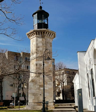
* Constanţa (1) (Farul Genovez)
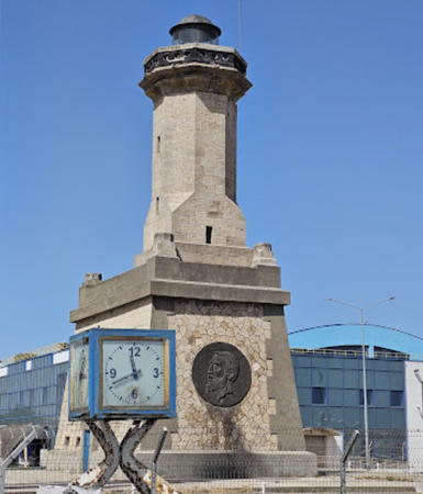
1886. Reactivated in 2020 but unofficial; inactive as an official light since 1913; charted as a landmark; continuous (?) white light. 8 m (26 ft) octagonal stone tower with lantern and gallery. The lighthouse is unpainted; lantern painted black or very dark blue. A photo appears at the top of this page, Jackson Lee has a photo, a good closeup is available, Wikimedia has photos, a 2022 Instagram photo shows the light in action, and Google has a street view and a satellite view. According to the Romanian Wikipedia, this tower was built by Genoese traders around 1300 and was restored around 1860. "Restored" may mean "rebuilt," but in any case this historic lighthouse was restored again in 1948 and has become a fairly well known tourist attraction. It was relighted in February 2020 after several years of effort by interested volunteers. It stands near the Casino on a headland projecting into the Black Sea north of the harbor but close to Constanţa's downtown business district. A historic postcard view posted by Klaus Huelse shows the lighthouse and Casino. Site open, tower closed. . ARLHS ROM-015.
Constanţa East (Outer) Breakwater
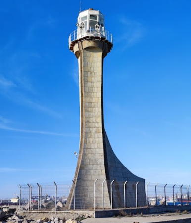
Date unknown. Active; focal plane 24 m (79 ft); white light, 1.5 s on, 3 s off. 18 m (59 ft) square hourglass-shaped unpainted masonry tower with lantern and gallery. Trabas has a closeup photo by Douglas Cameron (also seen at right), Valentin Frasinar has a 2018 photo, Marian Sima has a 2023 photo, and Google has a satellite view. This lighthouse was originally built at the end of the outer breakwater of Constanţa, but the breakwater has since been extended no less than 4 km (2.5 mi) southward, leaving the lighthouse at an elbow about 500 m (1600 ft) south of the East Breakwater Spur Light. Site status unknown. ARLHS ROM-004; Admiralty N5026; NGA 17700.
Constanta East Breakwater Light
Constanţa East Breakwater Light, Constanţa
photo copyright Douglas Cameron; used by permission
Constanţa East Breakwater Spur
1972. Active; focal plane 14 m (46 ft); green flash every 3 s. 9 m (30 ft) 2-story stone building with a lantern mounted at the east end. the building is unpainted; lantern painted green. Trabas has a photo by Capt. Theo Hinrichs of the lighthouse in action and Google has a satellite view. This light and the South Breakwater Light frame the entrance to the inner (north) harbor of Constanţa. Located at the end of a westward spur off the East (outer) Breakwater. Site status unknown. ARLHS ROM-010; Admiralty N5026.2; NGA 17704.
* Constanţa (2) (East Pier, King Carol I)
1913 (station established 1886). Inactive since 1961. Approx. 13 m (43 ft) octagonal stone tower with lantern and gallery, mounted at one end of a rectangular stone building. Lighthouse unpainted; lantern dome painted dark blue. A photo by Capt. Theo Hinrichs is at right, Ovidiu Limbide has a 2016 closeup photo, a 2019 closeup is available, Huelse has a historic postcard view, and Google has a satellite view. The lighthouse was dedicated to honor King Carol I, who died in 1914. It is known locally simply as the farul vechi (the old lighthouse). Located at the end of the old East Pier, which is now the root of the city's outer breakwater. Accessible by walking or driving the pier, about 1.5 km (1 mi) south from the Casino. Site open, tower closed. ARLHS ROM-017.
Constanţa South Breakwater
1972. Active; focal plane 14 m (46 ft); red flash every 3 s. 9 m (30 ft) 2-story stone building with a lantern mounted at the east end. The building is unpainted; lantern painted red. Trabas has a photo and Google has a satellite view. This light and the East Breakwater Spur Light frame the entrance to the inner (north) harbor of Constanţa. Located at the end of a pier on the west (mainland) side of the harbor. Site status unknown. ARLHS ROM-016; Admiralty N5026.4; NGA 17708.
* Constanţa Main (3)
1960 (station established 1886). Active; focal plane 87 m (285 ft); two white flashes, separated by 7 s, every 29.8 s. 58 m (190 ft) triangular concrete tower with lantern room. Most of the tower is white; the upper section of the seaward side and the lantern are painted a very dark blue, almost black. Wikipedia has a photo, a fine closeup photo and a 2009 photo are available, Trabas has a photo by Capt. Theo Hinrichs of the lighthouse in action, V. Soldan has a good view of the lighthouse and its surroundings, and Google has a street view and a satellite view. This striking modern lighthouse is located at the center of a broad plaza just west of the harbor area. The tower and its surrounding fountains are floodlit at night. Site open, tower closed. ARLHS ROM-002; Admiralty N5025; NGA 17692.

Farul Carol I, Constanţa, November 2015
photo copyright Capt. Theo Hinrichs; used by permission

Tuzla Commune Lighthouse
* Tuzla (Capul Tuzla)
1900. Active; focal plane 62 m (203 ft); two white flashes every 9.7 s; also a continuous red light is shown at 57 m (187 ft). 44 m (144 ft) square pyramidal cast iron skeletal tower with lantern, gallery, and enclosed watch room. Lighthouse painted with black and white horizontal bands. Nautophone fog signal (one 5 s blast every 30 s). Trabas has a closeup photo, a 2020 photo is available, Dan Surducan has a 2022 photo, Cristi Petrescu has a distant view, Lightphotos.net has an aerial photo, Huelse has a historic postcard view, and Google has a satellite view. This historic lighthouse was prefabricated in France by Barbier, Bernard, et Turenne. It is Romania's oldest active lighthouse. Possibly endangered: the lighthouse is reported to be in danger due to erosion of the bluff on which it stands, although it seems fairly secure at the present time. There are plans to move it but no funds are available for the project. In 2009 action was taken to shore up the bluff. Located on Capul (Cape) Tuzla, about 4 km (2.5 mi) southeast of Eforie Sud. Site status unknown, but there appears to be road access to the light station. ARLHS ROM-009; Admiralty N5022; NGA 17688.

Mangalia City Lighthouses
Founded by the Greeks as Callatis in the 4th century BCE, Mangalia is one of the oldest cities in Romania. Under the Ottoman Turks it was an important port known as Pangalia. Today it is a naval base, fishing port, and the center of Romania's beach resorts. Its population is about 40,000.

* Mangalia
1958. Active; focal plane 72 m (236 ft); two white flashes every 5.5 s. 42 m (138 ft) slender rectangular cylindrical white concrete tower. Radek Literski has contributed a photo, Trabas has Meyer's photo, a 2023 photo is available, and Google has a street view and a satellite view. Located on a hill 4 km (2.5 mi) west northwest of the harbor of Mangalia. Accessible by road. Site open, tower closed. ARLHS ROM-005; Admiralty N5018; NGA 17664.

Tuzla Light, Eforie Sud, September 2017
Mangalia News tourist development photo
* Mangalia Northeast Breakwater (3)
1979. Active; focal plane 23 m (75 ft); white light, 1.5 s on, 2.5 s off. 21 m (69 ft) skeletal tower with gallery and an open lantern structure; access to the gallery is by a spiral stairway inside the tower. Trabas has Meyer's photo and Google has a satellite view. Located at the end of the extended northeast breakwater. Site status unknown, but the light can certainly be viewed from nearby. Admiralty N5019; NGA 17668.
* Mangalia Northeast Breakwater Spur
1979. Active; focal plane 15 m (49 ft); green flash every 3 s. 13 m (43 ft) round masonry tower with lantern and gallery, attached to a 2-story masonry pier house. The lighthouse appears to be unpainted gray masonry. Trabas has a photo, Dzianis Kadyrko has a photo, and Google has a satellite view. Located at the end of a short spur off the northeast breakwater at Mangalia. Accessible by walking the pier. Site open, tower closed. ARLHS ROM-013; Admiralty N5019.5; NGA 17672.
* Mangalia Northeast Breakwater (2?)
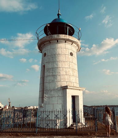
1952 (?) (station established 1897). Inactive, probably since 1979. 7 m (23 ft) round masonry tower with lantern and gallery. Lighthouse painted white; lantern dome painted dark blue. A photo by Américo Alves is at right, Alexandru Szilaghi has a closeup 2022 photo, Andrei Dan has a 2016 photo, Huelse has a postcard view, and Google has a satellite view. Mihai Balan's 2018 street view shows that the lighthouse had been repainted and refurbished recently. This lighthouse became obsolete when the northeast breakwater was extended and the southeast breakwater constructed, considerably expanding the harbor. The first light here was on a skeletal tower. Located at the end of the original northeast breakwater at Mangalia. Accessible by walking the pier. Site open, tower closed. . ARLHS ROM-006.
Mangalia Southeast Breakwater
1979. Active; focal plane 15 m (49 ft); red flash every 3 s. 13 m (43 ft) round masonry tower with lantern and gallery, attached to a 2-story masonry pier house. The lighthouse appears to be unpainted gray masonry; lantern painted red. Radek Literski has contributed a photo, Trabas has Meyer's photo, Munteanu Cosmin has a 2021 photo, and Google has a satellite view. Located at the end of the south breakwater pier at Mangalia, a broad pier with a road. Part of the naval base, this pier is closed to the public. Site and tower closed. ARLHS ROM-014; Admiralty N5020; NGA 17684.
Mangalia Northeast Breakwater Light
Mangalia Northeast Breakwater Light, Mangalia, May 2011
ex-Flickr photo copyright Américo Alves; used by permission

Information available on lost lighthouses:

Notable faux lighthouses:

Adjoining pages: North: Ukraine: Odessa Area | South: Bulgaria

Return to the Lighthouse Directory index | Ratings key

Posted January 18, 2007. Checked and revised September 13, 2023. Lighthouses: 25. Site copyright 2023 Russ Rowlett and the University of North Carolina at Chapel Hill.