Lighthouses of European Türkiye

Prior to World War I (1914-18) the Ottoman (Turkish) Empire had for centuries controlled most of the Middle East and (for varying amounts of time) North Africa and Southeast Europe. Following the war the Empire was partitioned by the 1920 Treaty of Sèvres and after a period of turmoil and warfare the Republic of Türkiye (Türkiye Cumhuriyeti in Turkish) was established in 1923. The country was historically called Turkey but in 2022 the Turkish government informed the United Nations that it prefers the official spelling Türkiye to be used in English. The Directory uses the spelling Türkiye in its descriptions but retains Turkish as the adjective form and preserves the more familiar spelling Turkey on the index page.

Most of Türkiye (97%) occupies the broad peninsula of Anatolia (Asia Minor) between the Black Sea and the Mediterranean Sea; the remaining 3% is the region of East Thrace at the southeastern corner of Europe. Between Anatolia and Thrace is the small Sea of Marmara (Marmara Denizi) connected to the Black Sea by the Bosporus (İstanbul Boğazı) and to the Aegean Sea by the Dardanelles (Çanakkale Boğazı) These narrow passages form a famous international waterway, lit by several historic lighthouses, connecting the Black Sea to the Mediterranean.

Türkiye is subdivided into 81 provinces (il or vilayet) for administrative purposes. Each province is divided into districts (ilçe). This page describes the lighthouses of East Thrace, including its Black Sea coast and the European side of the Bosporus, the Sea of Marmora, and the Dardanelles, as well as the island of Gökçeada (Imbros) in the northeastern corner of the Aegean Sea adjacent to the Dardanelles. Lights of the Asiatic side of the Straits are on the Northwestern Anatolia page.

Since the 1920s the Turkish language has been written in a Latin script; a distinctive feature of the alphabet is that the dotted (İ and i) and dotless (I and ı) forms of the letter I are different letters. The Turkish phrase for a lighthouse is fener (plural fenerler) or deniz feneri ("sea lantern"). Ada or adası is an island, yarımada is a peninsula, kaya is a rock or reef, burnu is a cape, burun ("nose") is a headland, körfez is a gulf, koy is a bay or inlet, boğaz is a strait, nehir is a river, and liman is a harbor.

Lighthouses in Türkiye are operated by the Directorate General of Coastal Safety (Kıyı Emniyeti Genel Müdürlüğü).

ARLHS numbers are from the ARLHS World List of Lights Admiralty numbers are from volume N of the Admiralty List of Lights & Fog Signals. U.S. NGA List numbers are from Publication 113. The official Turkish light list, Fenerler ve sis Isaretleri (Lights and Fog Signals), is not available online.

General Sources
Seyir Yardımcıları (Navigational Aids)
Information on major lighthouses posted by the Directorate General.
Online List of Lights - Turkey
Photos by various photographers posted by Alexander Trabas. Some of the photos are by Capt. Peter Mosselberger ("Capt. Peter").
Leuchttürme in Türkei
Photos by Andreas Köhler.
Lighthouses in Turkey
Photos by various photographers available from Wikimedia.
World of Lighthouses - Turkey
Photos by various photographers available from Lightphotos.net.
Deniz Fenerleri
Photos of 22 lighthouses by Haluk Özözlü.
Weitere Europäische Leuchttürme auf historischen Postkarten
Historic postcard images posted by Klaus Huelse.
Navionics Charts
Navigation chart for East Thrace.

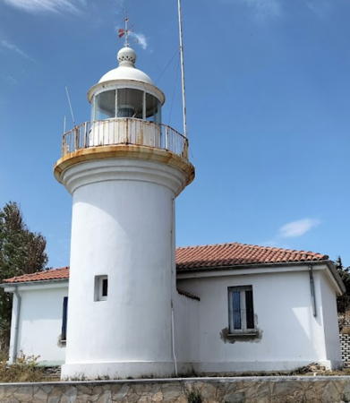
Ahırkapı Light, İstanbul, June 2013
Wikimedia Creative Commons photo by Dennis Jarvis

Western Black Sea Lighthouses

Kırklareli Province Lighthouses
* Beğendik Köyü (Beğendik Village) East Breakwater
Around 2012. Active; focal plane about 13 m (43 ft); green light, pattern unknown. Approx. 10 m (33 ft) round white concrete tower. This light is on the left in Ismail Ağır's photo of the two lights and at the far right in Halil İbrahim Aydın's drone view. Google has a satellite view. Located at the end of the east (main) breakwater of Beğendik. Accessible by walking the pier. Site open, tower closed. Admiralty N4967.
* Beğendik Köyü (Beğendik Village) West Breakwater
Around 2012. Active; focal plane about 13 m (43 ft); red light, pattern unknown. Approx. 10 m (33 ft) round white concrete tower. This light is on the right in Ismail Ağır's photo of the two lights and is on the shorter breakwater in Halil İbrahim Aydın's drone view. Google has a satellite view. Located at the end of the west (inner) breakwater of Beğendik. Accessible by walking the pier. Site open, tower closed. Admiralty N4967.3.
* Iğneada Burnu (Limanköy, Cape Kuri) (3)
1913 (station established 1866). Active; focal plane 44 m (144 ft); two white flashes every 15 s. 8 m (26 ft) round masonry tower, adjoining a 1-story masonry keeper's house. Entire lighthouse painted white. Kıvanç Beki's photo is at right, Özözlü has a photo, Trabas has a photo, Wikimedia has Ahmet Baris Isitan's photo, Okan Özkan has a drone view, and Google has a satellite view. The original lighthouse, built by French engineers, was destroyed in 1903 and replaced by a temporary light. However, the lighthouse continues to be known locally as the "French Lighthouse." Located near Limanköy at the tip of the cape, which projects into the Black Sea about 8 km (5 mi) south of the Bulgarian border. Site open, tower closed. Admiralty N4966; NGA 17528.
Iğneada East Breakwater
Date unknown. Active; focal plane 13 m (43 ft); green flash every 3 s. 12 m (39 ft) round concrete tower. Lighthouse painted white with one narrow green horizontal band. Trabas has a photo, Necla Kelesoglu has a view showing both breakwater lights, and Google has a satellite view. Located at the end of the east (main) breakwater of Iğneada. Site status unknown. Admiralty N4966.4; NGA 17532.
Iğneada West Breakwater
Date unknown. Active; focal plane 13 m (43 ft); continuous red light. 12.5 m (41 ft) round concrete tower. Lighthouse painted white with one narrow red horizontal band. Trabas has a photo, Necla Kelesoglu has a view showing both breakwater lights, and Google has a street view and a satellite view. Located at the end of the west breakwater of Iğneada. Site status unknown. Admiralty N4966.6; NGA 17536.
* Kıyıköy (Taş Burnunda)
Date unknown. Active; focal plane 37 m (121 ft); white flash every 10 s. 6 m (20 ft) round barbell-shaped tower painted white with one black horizontal band. Trabas has a photo, Taner Sızanlı has a photo, Bayram Aydın has a street view, and Google has an indistinct satellite view. Located in front of a café on a headland at Kıyıköy. Site open, tower closed. Admiralty N4965; NGA 17524.

Iğneada Burnu Light, Limanköy, August 2023
Google Maps photo by Kıvanç Beki

İstanbul Province: North Coast Lighthouses
* Rumeli Karaburun (2)
1968 (station established 1856). Active; focal plane 54 m (177 ft); white flash every 5 s. 9 m (30 ft) octagonal cylindrical concrete tower with 8 ribs, lantern, and gallery. 2nd order (?) Fresnel lens in use. Entire lighthouse is white. Trabas has Eckhard Meyer's closeup photo, Ozan Kilic has a dramatic nighttime photo, Tolga Davaz has a street view, and Google has a street view and a satellite view. NGA lists the light as a stone tower. The original lighthouse was much higher, with a focal plane of 92 m (302 ft); we don't know if that lighthouse survives. Karaburan (Black Cape) is a common place name in Türkiye and several lighthouses have that name. Located on a short, sharp promontory at Karaburun, about 40 km (25 mi) northwest of İstanbul. Site open, tower closed. ARLHS TUR-036; Admiralty N4964; NGA 17520.
* [Dalyan Burnu (2)]
Date unknown. Active; focal plane 25 m (82 ft); three flashes every 10 s, white or red depending on direction. 8 m (26 ft) round cylindrical white concrete tower. A 2020 photo is available, Khaled Almasarei has a 2017 photo showing the new light, and Google has a satellite view. Trabas has a photo of the original light, a white skeletal tower. Located on a promontory at Kumköy, about 8 km (5 mi) west of the Rumeli lighthouse. Site open, tower closed. Admiralty N4962; NGA 17516.
*** Rumeli (Türkeli) (2)
1856 (station established 1830). Active; focal plane 58 m (190 ft); two white flashes every 12 s. 30 m (98 ft) 2-stage octagonal stone tower with lantern and gallery, painted white. An octagonal control tower in front of the lighthouse monitors ship traffic entering the Bosporus from the Black Sea. A photo is at right, Trabas has a photo, an excellent 2008 closeup is available, Wikimedia has a photo, Özözlü has a photo, and Google has a satellite view. Google's 2023 street view shows the lighthouse under restoration. This is Türkiye's tallest lighthouse and a masterpiece of Ottoman lighthouse architecture. Rumeli (or Rumelia) is an old name for the Turkish possessions in Europe, and this lighthouse stands on the west (Rumelian or Thracian) side of the entrance to the Bosporus from the Black Sea. Lights were shown from this location as early as the 16th century. During the Crimean War (1853-56) the Ottoman Empire granted Britain and France a 100-year concession to build and operate a lighthouse here. During early phases of construction the French builders discovered that the chosen site is on top of an ancient mausoleum. They revised their plans to allow access to the mausoleum, which remains open today. The 100-year concession was cancelled by Turkey's republican government in 1933. Located in the village of Rumelifeneri (Rumeli Lighthouse). Site open; the tower is listed by the Coastal Safety Directorate as open to visitors but I have not seen any photos of the interior or views from the top. . ARLHS TUR-053; Admiralty N4956; NGA 17496.

Rumeli Light, Rumelifeneri, January 2014
Wikimedia Creative Commons photo by VikiPicture

İstanbul Province: Bosporus West Side Lighthouses

The Bosporus is the strait connecting the Black Sea to the Sea of Marmara, which in turn connects to the Mediterranean Sea. Known to Turks as the İstanbul Strait (İstanbul Boğazı) or simply as Boğaz (The Strait), the Bosporus is the narrowest of all the major straits commonly used by international shipping. It narrows from about 3700 m (2.3 mi) at the Black Sea entrance to about 700 m (2300 ft) at downtown İstanbul. Three major bridges cross the Bosporus, and there is also an undersea railway tunnel. There are many lights along the strait and only the larger towers are listed here. In keeping with international conventions the lights on the west side of the strait all have green lights. For lights on the east side of the strait see the Northwestern Anatolia page.

Dikili Tas (Dikilikaya, Rumeli Kavaği)
Date unknown. Active; focal plane 9 m (30 ft); two green flashes every 10 s. 9 m (30 ft) round hourglass-shaped tower, painted white with two narrow green horizontal bands, mounted on a concrete pier. Trabas has Capt. Peter's photo (also seen at right), a 2014 closeup is available, and Google has a sea view and a satellite view. This light marks the point where the strait narrows for southbound vessels to a width of about 1500 m (0.9 mi). Located on a rock (tas) off the west side of the strait at the village of Rumeli Kavaği. Accessible only by boat. Site open, tower closed. Admiralty N4955; NGA 17484.
* Büyükdere
Date unknown. Active; focal plane 12 m (39 ft); three green flashes every 15 s. 9 m (30 ft) round hourglass-shaped tower, painted white with one narrow green horizontal band. Trabas has a photo, and Google has a street view and a satellite view. Located in Büyükdere, a town just north of Serıyer on the west side of the strait. Site open, tower closed. Admiralty N4952; NGA 17468.
* Kireç Burnu (Kireçburnu)
Date unknown. Active; focal plane 11 m (36 ft); three green flashes every 15 s. 9 m (30 ft) round hourglass-shaped tower, painted white with three narrow green horizontal bands, mounted on a concrete pier. Trabas has a photo, Mohammad Reza Babaei has another photo, and Google has a street view and an indistinct satellite view. This light acts as a leading light for southbound vessels and marks a wide turn in the course of the strait. Located on the waterfront of Kireç Burnu, a town at the northern edge of İstanbul. Site open, tower closed. Admiralty N4950; NGA 17452.
* İstinye
Date unknown. Active; focal plane 14 m (46 ft); two green flashes every 10 s. 10 m (33 ft) round hourglass-shaped tower, painted white with green horizontal bands. Trabas has a closeup photo and Google has a sea view and an indistinct satellite view. This light marks the entrance to a small boat harbor on the west side of the strait. Located on a promontory on the west side of the strait at İstinye, opposte Pasabahce. Site open, tower closed. Admiralty N4949; NGA 17436.

Dikili Tas Light, Rumeli Kavaği
photo copyright Capt. Peter Mosselberger; used by permission
* Balta Limanı
Date unknown. Active; focal plane 12 m (39 ft); green flash every 3 s. 10 m (33 ft) round hourglass-shaped fiberglass tower. Lighthouse painted white with one narrow green horizontal band. Trabas has a good photo and Google has a sea view, a street view and a satellite view. This light acts as a leading light for southbound vessels. Located on the west side of the Bosporus in the Baltalimanı neighborhood, north of the Sultan Mehmet Bridge. Site open, tower closed. Admiralty N4947; NGA 17424.
* Aşiyan Burnu
Date unknown. Active; focal plane 12 m (39 ft); three green flashes every 15 s. 10 m (33 ft) round hourglass-shaped fiberglass tower. Lighthouse painted white with three narrow green horizontal bands. Capt. Peter's photo is at right, Trabas has a good photo, and Google has a sea view, a street view and a satellite view. This light acts as a leading light for northbound vessels. An earlier light, still listed by NGA, was mounted on the wall of a nearby fortress. Located on the west side of the Bosporus at a pronounced bend in the channel in the Aşiyan neighborhood. Site open, tower closed. Admiralty N4946; NGA 17420.
* Arnavutköy (Akıntı Burnu)
Date unknown. Active; focal plane 11 m (36 ft); green flash every 3 s. 9 m (30 ft) round hourglass-shaped fiberglass tower with gallery. Lighthouse painted white with one narrow green horizontal band. Trabas has a good photo, Lightphotos.net has a photo, and Google has a sea view, a street view and a satellite view. Southbound vessels pass quite close to this light. Located on a headland of the west side of the Bosporus in the Arnavutköy neighborhood, halfway between the Boğaziçi and Sultan Mehmet bridges. Site open, tower closed. Admiralty N4940; NGA 17408.
* Defterdar Burnu
Date unknown. Active; focal plane 15 m (49 ft); two green flashes every 12 s. 12 m (39 ft) round hourglass-shaped fiberglass tower with gallery. Lighthouse painted white with two narrow green horizontal bands. Trabas has a Capt. Peter's photo and Google has a sea view, but the light is hard to find in Google's satellite view. Located on the west side of the Bosporus in the Ortaköy neighborhood, a short distance north of the Boğaziçi bridge. Site open, tower closed. Admiralty N4937.4; NGA 17396.
* Salıpazarı
Date unknown. Active; focal plane 13 m (43 ft); three green flashes every 10 s. 10 m (33 ft) round hourglass-shaped fiberglass tower. Lighthouse painted white with three narrow green horizontal bands. Trabas has a good photo and Google has a sea view, a street view, and a satellite view. Located on a small wharf on the west side of the Bosporus opposite the Kız Kulesi (Maiden's Tower; see Northwestern Anatolia). Site open, tower closed. Admiralty N4903.7; NGA 17388.
Aşiyan Burnu Light
Aşiyan Burnu Light, İstanbul
photo copyright Capt. Peter Mosselberger; used by permission

Sea of Marmara North and West Coast Lighthouses

The Sea of Marmara is about 280 km (175 mi) long from east to west and about 80 km (50 mi) wide. The Bosporus connects the Black Sea to the northeastern corner of the Sea of Marmara, and the Dardanelles connects the Aegean Sea to the southwest corner.

İstanbul Province: Southwest İstanbul Lighthouses
* Ahırkapı (2)
1857 (station established 1755). Active; focal plane 36 m (118 ft); white flash every 6 s. 26 m (85 ft) round stone tower with lantern and gallery, attached to a 1-story stone keeper's house. Lighthouse painted white with one narrow black horizontal band. Dennis Jarvis's photo appears at the top of this page, Köhler has a good photo, Lightphotos.net has a photo, Trabas has a closeup photo, KEGM has a page for the lighthouse, and Google has a sea view, a street view and a satellite view. This lighthouse stands on the west side of the entrance (kapı) to the Bosporus from the Sea of Marmara. Sultan Osman III ordered a lighthouse built here in 1755 after witnessing the rescue of seamen from a wrecked galleon. Located on the land side of the waterfront boulevard, the Kennedy Caddesi, on Ahırkapı Burnu. Site open, tower closed. ARLHS TUR-056; Admiralty N4903; NGA 17340.
Kumkapı Barınak (Kumkapı Shelter)
Date unknown. Active; focal plane 10 m (33 ft); red flash every 3 s. 9 m (30 ft) round cylindrical white concrete tower with one narrow red horizontal band. Trabas has a photo and Google has a street view, a sea view and a satellite view. Located at the end of the breakwater of the Kumkapı fishing harbor, about 1.2 km (3/4 mi) southwest of the Ahırkapı lighthouse. Site open, tower closed. Admiralty N4903.4; NGA 17108.
Yenikapı ("New Gate")
Date unknown. Active; focal plane 9 m (30 ft); two red flashes every 5 s. 6 m (20 ft) round tower rising from an expanded base. Lighthouse is white with two narrow red horizontal bands. Trabas has a photo, Hassan Borairi has a very distant street view, and Google has a satellite view and a very distant sea view. Located at the end of the breakwater sheltering the Yenikapı ferry terminal, about 2 km (1.25 mi) southwest of the Ahırkapı lighthouse. Site open, tower closed. Admiralty N4903.45; NGA 17106.
* Ataköy (Bakırköy) Marina
Date unknown. Active (privately maintained); focal plane 13 m (43 ft); red flash every 3 s. 11 m (36 ft) mast atop a 2-story pierhead restaurant. Trabas has a photo, Lightphotos.net has a photo, Inanc Kucukosmanoglu has a view from the sea, and Google has a satellite view. Located on the breakwater pier of the Ataköy marina in the Bakırköy neighborhood of southwestern İstanbul, about 5 km (3 mi) east of the Yeşilköy lighthouse. Site open, tower closed. Admiralty N4902.5; NGA 17105.
* Yeşilköy (Agios Stefanos, St. Stefanos)
1856. Active; focal plane 23 m (75 ft); white flash every 10 s. 18 m (59 ft) octagonal stone tower centered on a 1-story octagonal keeper's house. Lighthouse painted white. Gökhan Gezer's photo is at right, Trabas has a good photo, Özözlü has a good photo showing how a skyscraper overshadows the lighthouse today, Hasan Kirmizi has a photo, Mehmet Akif Andazman has a 2022 photo, KEGM has a page for the lighthouse, Wikimedia has a photo, Huelse has a historic postcard view, and Google has a street view and a satellite view. The oldest lighthouse on the Sea of Marmara, this lighthouse serves as a landfall light for vessels arriving in İstanbul from the Sea of Marmara. Located at the end of the Fener Yolu Caddesi in Yeşilköy ("Green Bay"), about 12 km (7.5 mi) southwest of downtown İstanbul, near the international airport. Site open, tower closed. ARLHS TUR-055; Admiralty N4902; NGA 17104.

Yeşilköy Light, İstanbul, January 2021
Google Maps photo by Gökhan Gezer
Değirmen Burnu
Date unknown. Active; focal plane 20 m (66 ft); white flash every 5 s. 8 m (26 ft) round white concrete tower with a narrow black horizontal band. Trabas has a photo (before the band was added) and Google has a satellite view. Located on a bluff in the Avcılar district in southwestern İstanbul. Site status unknown. Admiralty N4899.6; NGA 17092.

Tekirdağ Province Lighthouses
* Marmara Ereğlisi (Ereğli)
1861. Active; focal plane 53 m (174 ft); white flash every 10 s. Approx. 8 m (26 ft) octagonal cast iron tower with lantern and gallery, attached to a 1-story keeper's house. Lighthouse painted white. Trabas has a good photo, Kasım Oktay has a photo, a 2021 photo is available, Aysel Fettah has a view from below the lighthouse, and Google has a satellite view.The Admiralty and NGA Light Lists have the tower height as 26 m (85 ft) rather than 26 ft, a rather obvious mistake that has persisted for many years. Located on a sharp promontory at Marmara Ereğli, about 32 km (20 mi) east of Tekirdağ on the central north coast of the Sea of Marmara. Site apparently open, tower closed. ARLHS TUR-059; Admiralty N4898; NGA 17072.
Örencik (Venedik)
Date unknown. Active; focal plane 9 m (30 ft); white flash every 6 s. 9 m (30 ft) square concrete block tower topped by a 5 m (17 ft) hourglass-shaped white tower. Trabas has a photo and Bing has an indistinct satellite view. Located on a reef off Marmara Ereğli, about 7 km (4 mi) west of the lighthouse. Accessible only by boat. Site open, tower closed. Admiralty N4897; NGA 17068.
 

Marmara Ereğlisi Light, Marmara Ereğlisi
KEGM photo
 
* Tekirdağ Outer Breakwater
Date unknown. Active; focal plane about 12 m (39 ft); green flash every 4 s. Approx. 8 m (26 ft) round white concrete tower. Trabas has a photo, Barbaros Karagülmez has a distant street view, and Google has a satellite view. Located on the main breakwater of the yacht harbor at Tekirdağ. Accessible by walking the pier. Site open, tower closed. Admiralty N4896.74; NGA 17064.4.
* Tekirdağ Inner Breakwater
Date unknown. Active; focal plane about 12 m (39 ft); red flash every 4 s. Approx. 8 m (26 ft) round white concrete tower. Trabas has a photo, Barbaros Karagülmez has a street view, and Google has a satellite view. Located on the west breakwater of the yacht harbor at Tekirdağ. Accessible by walking the pier. Site open, tower closed. Admiralty N4896.72; NGA 17064.6.
** Hoşköy ("Pleasant Bay," Hora)
1861. Active; focal plane 50 m (164 ft); two white flashes every 10 s. 22 m (72 ft) 12-sided cast iron tower with lantern and gallery, attached to a 1-story keeper's house. Lighthouse painted white. Suna Öztürk has a closeup photo and the photo at right, Trabas has a good photo, İbrahim Solar has a 2017 photo, Özgür Yılmaz has a distant view, Emre Yetim has a street view, and Google has a satellite view. This historic lighthouse stands on the west side of the Sea of Marmara and acts as a leading light guiding southbound ships toward the Dardanelles. Prefabricated in France, the lighthouse retains its original Fresnel lens and clockwork mechanism. In 2017 it was reported in poor condition and in need of restoration. The Tekirdağ Metropolitan Municipality and Şarköy Municipality expressed some desire to acquire it as a tourist attraction. This may have happened; Arseniy Kiselev has a 2021 photo showing the lighthouse refurbished and repainted. Located near the village of Hoşköy, about 20 km (13 mi) northeast of the larger town of Sarköy. Site open, tower may be open by arrangement with the keeper. ARLHS TUR-025; Admiralty N4896; NGA 17060.
İnce Burnu
1953. Active; focal plane 32 m (105 ft); three white flashes every 10 s. 10 m (33 ft) round cylindrical concrete tower with gallery, painted white. Trabas has a photo and Google has a satellite view. İnce Burnu (Sharp Cape) is the name of several Turkish lighthouses. Located on a prominent cape on the northwest side of the Dardanelles entrance about 15 km (9 mi) southwest of Sarköy. Site status unknown. ARLHS TUR-027; Admiralty N4880; NGA 17056.

Hoşköy Light, Hoşköy, October 2017
ex-Google Plus photo by Suna Öztürk

Western Çanakkale Province Lighthouses

The larger part of of Çanakkale Province is on the Anatolian mainland but the province extends across the Dardenelles to include the Gallipoli Peninsula and the island of Gökçeada. Lighthouses of the rest of the province are listed on the Northwestern Anatolia page and the Western Türkiye page. The strait is crossed by the 1915 Çanakkale Bridge, completed in 2022; the bridge includes the world's longest suspension span, with a length of 2023 m (1.257 mi).

Dardanelles European Side Lighthouses
The Dardanelles is the strait connecting the Sea of Marmara to the Aegean Sea. The strait is 61 km (38 mi) long and varies in width from 1.2 km (3/4 mi) to 6 km (3.7 mi). The strait was also known historically as the Hellespont, but its modern Turkish name is the Çanakkale Strait (Çanakkale Boğazı) after the town of Çanakkale on the east shore of the strait.

* Gelibolu (Gallipoli)
1856. Active; focal plane 34 m (112 ft); white flash every 5 s. 9 m (30 ft) round cylindrical masonry tower with lantern and gallery, attached to a 1-story masonry keeper's house. Lighthouse painted white. Tuba Gül's photo is at right, Trabas has a closeup photo, Debby Yang has a 2022 photo, Ben Rose has a distant view and a closeup, Huelse has a historic postcard view, and Google has a satellite view. This lighthouse marks the northern entrance to the narrow portion of the Dardanelles. Gelibolu (Gallipoli) was the scene of an unsuccessful siege by Allied troops in 1915, during World War I. The battlefields are a major tourist attraction but the lighthouse doesn't get as much attention from visitors. Located in a municipal park on a bluff in Gelibolu, on the northwest side of the strait. Site open, tower closed. ARLHS TUR-023; Admiralty N4878; NGA 17048.
Karakova (2)
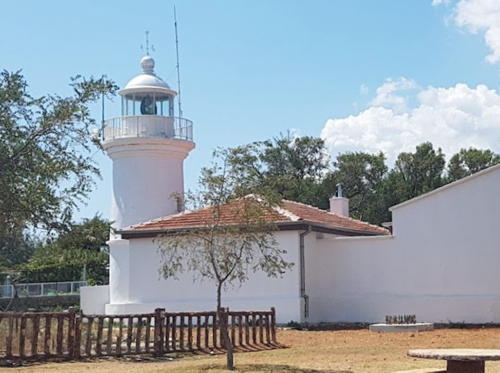
Date unknown (station established 1858). Active; focal plane 10 m (33 ft); red flash every 6 s. 10 m (33 ft) round barbell-shaped metal or fiberglass tower, painted white with a narrow red horizontal band. A ruined keeper's cottage, white with a red tile roof, stands near the lighthouse. A photo is available, Trabas has a distant photo, Charles Bash has a small Coastal Directorate photo (1/4 the way down the page), and Bing has a distant satellite view. Located on a point of land projecting from the European side of the strait about 9 km (4.5 mi) southwest of Gelibolu. Site status unknown. Admiralty N4872; NGA 17036.

Gelibolu Light, Gelibolu, August 2019
Google Maps photo by Tuba Gül
Uzun Burnu ("Long Cape")
Date unknown. Active; focal plane 11 m (36 ft); two red flashes every 10 s. 10 m (33 ft) round barbell-shaped metal or fiberglass tower, painted white with a narrow red horizontal band. Trabas has a closeup photo and Google has an indistinct satellite view. Located on the west side of the strait about 15 km (9 mi) southwest of Burhanlı. Site status unknown. Admiralty N4868; NGA 17028.
#Eceabat Range Front
1969. Inactive since 2017. 11 m (36 ft) square pyramidal skeletal tower with gallery. Beside the lighthouse is a square 1-story concrete equipment building. The tower also carries a diamond-shaped slatted daymark. Entire lighthouse and daymark painted white. Trabas has a photo and Google has a satellite view. Google's 2023 street view confirms the light has been removed. The range guided southbound vessels approaching a near right-angle turn in the strait. The tower may have been removed. Located on a hillside in Eceabat, on the west (European) side of the strait. Site status unknown. ex-Admiralty N4858; ex-NGA 17004.
Eceabat Range Rear (?)
1969. Inactive since 2017. 13 m (43 ft) square pyramidal skeletal tower with gallery, mounted on a square 1-story concrete equipment building. The tower also carries a white diamond-shaped slatted daymark. Entire lighthouse and daymark painted white. Trabas has a photo and Google has an indistinct satellite view. The tower has probably been removed. Located on a wooded hillside in Eceabat, on the west (European) side of the strait. Site status unknown. ex-Admiralty N4858.1; ex-NGA 17008.
* Mehmetçik (Cape Helles) (2)
1919 (station established 1856). Active; focal plane 50 m (164 ft); flash every 5 s, white or red depending on direction. 25 m (82 ft) round masonry tower with lantern and gallery, attached to a 1-story masonry keeper's house. 2nd order (?) Fresnel lens in use. Lighthouse painted white. Z Nazif Özcan's photo is at right, Trabas has Capt. Peter's 2015 photo, a good 2005 photo is available, Cira Lea has a 2023 photo, Lightphotos.net has a view from the sea, and Google has a satellite view. The original lighthouse, a 10 m (33 ft) stone tower, did not survive World War I. Cape Helles is the cape at the north (European) side of the Dardanelles (or the Hellespont, as it was known in ancient Greece). Located on the point of the cape near Seddülbahir. Parking is available at the nearby Helles Memorial but the entrance to the lighthouse is unmarked. Site open, tower closed. ARLHS TUR-042; Admiralty N4850; NGA 16956.

Mehmetçik (Cape Helles) Light, Seddülbahir, August 2021
ex-Google Maps photo by Nazif Özcan

Gökçeada (Imbros) Lighthouse
The 1923 Treaty of Lausanne between Greece and Türkiye confirmed Turkish ownership of all of the Anatolian mainland and Greek ownership of all of the Aegean islands except Gökçeada (Imbros or İmroz) and Bozcaada (Tenedos). These two islands were placed under Turkish administration because they flank the entrance to the Dardanelles. The islands are administered as part of Çanakkale Province. Bozcaada lighthouses are listed on the Western Turkey page.

*
Kaleköy
1960. Active; focal plane 49 m (161 ft); white flash every 3 s. 9 m (30 ft) square pyramidal skeletal tower mounted atop a square 1-story concrete equipment room. Entire lighthouse painted white. Trabas has Eckhard Meyer's photo, Charles Bash has a small Coastal Directorate photo (second photo on the page), and Google has a distant satellite view. This light guides ships into the harbor of Kaleköy, the principal port of Gökçeada. Gökçeada, the largest Turkish island in the Aegean Sea, is about 16 km (10 mi) northwest of Cape Helles, the entrance to the Dardenelles. Located atop a steep bluff on the east side of the harbor of Kaleköy, on the north side of Gökçeada. Site open, tower closed. Admiralty N4559.4; NGA 16932.

Saros Bay Lighthouse
Saros Bay (or the Gulf of Saros) is an inlet at the northeastern corner of the Aegean Sea; it separates the Galipoli Peninsula from the mainland of East Thrace.

Bakla Burnu
Date unknown. Active; focal plane 16 m (52 ft); white flash every 3 s. 8 m (26 ft) round barbell-shaped metal tower painted white. Trabas has a closeup photo, Süleyman Alantuğ has a photo and a street view, and Google has a satellite view. Located at the tip of a sharp promontory on the north side of the Gallipoli Peninsula. Site open, tower closed. Admiralty N4557.6; NGA 16948.

Information available on lost lighthouses:

Notable faux lighthouses:

Adjoining pages: North: Bulgaria | East: Northwestern Anatolia | West: Northern Greece

Return to the Lighthouse Directory index | Ratings key

Created April 16, 2007. Checked and revised October 3, 2023. Lighthouses: 38. Site copyright 2023 Russ Rowlett and the University of North Carolina at Chapel Hill.