Lighthouses of Spain: Ibiza and Formentera

The Kingdom of Spain occupies nearly 85% of the Iberian Peninsula in southeastern Europe with coastlines facing south and southeast on the Mediterranean Sea and northwest on the Atlantic Ocean. Spain also includes the Balearic Islands in the Mediterranean, the Canary Islands in the Atlantic, and the cities of Ceuta and Melilla on the north coast of Morocco.

The Balearic Islands are an archipelago in the Mediterranean off the east coast of Spain. Mallorca (Majorca) is by far the largest of the islands; the other principal islands are Menorca (Minorca) to the northeast and Ibiza (Eivissa) and Formentera to the southwest. The islands were conquered by the Kingdom of Aragon in the 13th century and have been part of Spain for several centuries. The Catalan language is spoken and the islands are known officially by their Catalan name, Illes Balears. In the 20th century the Balearics became very popular resort destinations.

This page includes lighthouses of Ibiza, Formentera and nearby islets; this group is sometimes called the Pityusic Islands (from the Greek for Pine Islands).

In Catalan the word for a lighthouse is far, balisa is a beacon, illa is an island, cap is a cape, punt is a promontory or point of land, roca is a rock, escull is a reef, badia is a bay, ria is an estuary or inlet, estret is a strait, riu is a river, and port is a port or harbor. The word for a lighthouse is faro in Spanish but its use is generally restricted to the larger coastal light stations. Smaller lighthouses are called balizas (beacons). In Spanish isla is an island, cabo is a cape, punta is a promontory or point of land, péñon is a rock, arrecife is a reef, bahía is a bay, ría is an estuary or inlet, estrecho is a strait, río is a river, and puerto is a port or harbor.

Navigational lights in Spain are the responsibility of the national port authority, Puertos del Estado, but many of them are operated and maintained by regional port authorities. The Balearics have their own port authority, the Autoritat Portuària de Balears. The Comisión de Faros, founded in 1842 to build and maintain Spanish lighthouses, is now an advisory panel.

ARLHS numbers are from the ARLHS World List of Lights. ES numbers are from the Spanish national list of lights, Libro de Faros. Admiralty numbers are from volume E of the Admiralty List of Lights & Fog Signals. U.S. NGA List numbers are from Publication 113.

General Sources
Libro de Faros y Señales de Niebla
Online edition of the official Spanish light list.
Fars de Balears (Balearic Lighthouses)
An outstanding and comprehensive web site posted by the port authority, with versions in English as well as Spanish and Catalan.
Online List of Lights - Islas Baleares
Photos by various photographers posted by Alexander Trabas. Most of the photos for this area are by Peter Doll or Rainer Arndt.
Faros de las Islas Baleares
Photos by Laure Chappuis posted by Alain Guyomard and Robert Carceller on their web site, Le phare à travers le monde.
Lighthouses in Balearic Islands
Photos by various photographers available from Wikimedia.
World of Lighthouses - Non-continental Spain
Photos by various photographers available from Lightphotos.net.
Spain Lighthouses
Aerial photos posted by Marinas.com.
Leuchttürme Spaniens auf historischen Postkarten
Historic postcard images posted by Klaus Huelse.
GPSNauticalCharts
Navigational chart information for the islands.
Navionics Charts
Navigational chart for the islands.


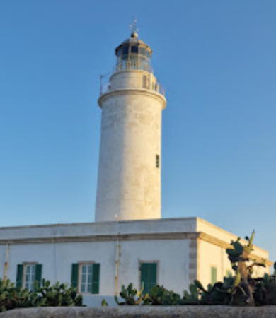
Sa Mola Light, Formentera, May 2022
Google Maps photo by Andrés Frontera

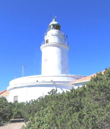
Coves Blanques Light, Sant Antoni de Portmany, April 2022
Google Maps photo by Julio Manuel Merino
Formentera Lighthouses

Formentera, the smallest of the four major islands, is located at the southwestern end of the archipelago about 6 km (3.5 mi) south of Ibiza. The island is 19 km (12 mi) in length and has a permanent population of about 12,000. There is no airport, so all visitors must arrive by boat; ferry service is available from Ibiza.
* Formentera (Sa Mola, La Mola)
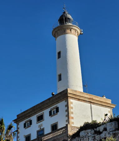
1861 (Emili Pou). Active; focal plane 142 m (466 ft); white flash every 5 s. 22 m (72 ft) round masonry tower with lantern and gallery, rising from the center of a 1-story masonry keeper's house. Lighthouse painted white; lantern is gray metallic. Andrés Frontera's 2022 photo is at the top of this page, Trabas has Le Bret's closeup, a fine view from the sea is available, Marinas.com has aerial photos, and Google has a street view and a satellite view. This lighthouse stands at the eastern tip of the island and is an important guide for ships passing to the south of the islands; it has a listed range of 23 nautical miles (42.5 km, 26.5 mi). The lighthouse still has its original Henry Lepaute lantern. However, it is very close to the edge of a vertical cliff and may be endangered. "Sa Mola" is a roughly circular plateau that forms the eastern portion of Formentera and is connected to the main part of the island by a sandy isthmus. Accessible by road; parking provided. Located about 15 km (9 mi) east of the town of Formentera. Site open, tower closed. . ARLHS BAL-047; ES-32700; Admiralty E0250; NGA 4744.
* Cap Barbaria (Cabo Barbaria, Cabo Berberia)
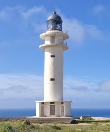
1972 (Rafael Soler). Active; focal plane 78 m (256 ft); two white flashes every 15 s. 19 m (62 ft) round cylindrical tower with lantern and double gallery, rising from a circular 1-story equipment room. Lighthouse painted white; lantern is gray metallic. A 2021 photo by PauLa Sánchez is at right, a photo taken from the sea shows the situation of the lighthouse atop a sheer, barren cliff. José Téllez has a good photo, Trabas has Peter Doll's closeup, PauLa Sánchez has a good 2021 photo (misidentified as the Far de la Mola), and Google has a street view and a satellite view. Located at the southwestern tip of the island, about 10 km (6 mi) southwest of the town of Formentera; accessible by road. Site open, tower closed. . ARLHS BAL-013; ES-32750; Admiralty E0251; NGA 4748.
* La Savina (Cala Sabina)
Date unknown. Active; focal plane 13 m (43 ft); four white flashes every 16 s. 11 m (36 ft) round cylindrical white concrete tower centered on a circular 1-story white concrete equipment room. Access to the light is by an external stairway that spirals around the tower. Trabas has Peter Doll's closeup, Chris Rivers has a 2009 photo, and Google has a street view and a satellite view. Located on the point at the west side of the entrance to the harbor of La Savina, the only port of Formentera. Good views from ferries arriving from Ibiza. Site open, tower closed. . ARLHS BAL-011; ES-32800; Admiralty E0252; NGA 4752.
Islote Casteví (Gastabi)
Date unknown. Active; focal plane 12 (39 m); nine quick white flashes every 15 s. 8 m (26 ft) post centered on a broadly conical base. Tower painted yellow with one black horizontal band. Trabas has Darlene Chisholm's photo and Google has a satellite view. Located on an island on the east side of the approach channel to La Savina. Accessible only by boat. Site open, tower closed. ES-32610; Admiralty E0253.5; NGA 4774.

Cap Barbaria Light, Formentera, April 2021
Google Maps photo by PauLa Sánchez
Illa d'en Pou (Isla de los Puercos)
1864 (Emili Pou). Active; focal plane 28 m (92 ft); four white flashes, in a 3+1 pattern, every 20 s. 25 m (82 ft) round masonry tower with lantern and gallery, painted with black and white horizontal bands. 1-story abandoned masonry keeper's house. Trabas has Peter Doll's photo, a 2020 view from the sea is available, Marinas.com has aerial photos, and Google has a satellite view. Los Puercos are no-goods, scoundrels. Keepers were at the mercy of the sea on this exposed island, and in 1913 a storm destroyed the keeper's house, although the keepers were saved. Located on an islet off the northernmost point of Formentera. Accessible only by boat; there are excellent views from ferries between the two islands. Site open, tower closed. Site manager: Parc Naturel de ses Salines. ARLHS BAL-039; ES-32580; Admiralty E0254; NGA 4772.
Illa Espardell
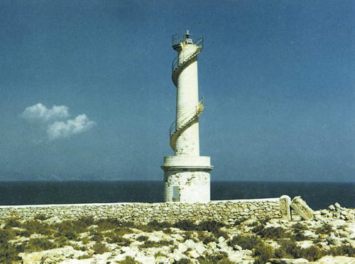
1926. Active; focal plane 37 m (121 ft); three white flashes every 7.5 s. 16 m (52 ft) round stone tower, rising from a round 1-story stone equipment room. Access to the light is by an external stairway that spirals around the tower. Lighthouse painted white. A closeup photo is at right, Trabas has Arndt's distant view and Google has a satellite view. This light shares its design with the Savina light (see above). Located on the northern tip of the Isla Espardell, an island about 5 km (3 mi) northeast of the northernmost point of Formentera. Accessible only by boat, and the island is a protected nature reserve. Site and tower closed. Site manager: Parc Naturel de ses Salines. ARLHS BAL-041; ES-32600; Admiralty E0256; NGA 4768.

Espardell Light, Eivissa
Consell d'Eivissa photo from L’Enciclopèdia d’Eivissa i Formentera

Eivissa (Ibiza) Lighthouses

Eivissa, known as Ibiza in Spanish and sometimes as Iviza in English, is a popular resort island with a permanent population of about 160,000. The island has an international airport with flights from many of the larger cities of Europe.

Sant Josep de sa Talaia (Southwest Coast) Lighthouses
Illa des Penjats (Islote Ahorcados, Los Freus, Freu Grande)
1856 (Antonio López y Montalvo). Active; focal plane 27 m (89 ft), white light occulting three times, in a 1+2 pattern, every 14 s. 20 m (66 ft) round masonry tower with lantern and gallery, rising from the center of a 1-story masonry keeper's house. Lighthouse painted with black and white horizontal bands. Carlos Mejía Greene has a photo, Trabas has Peter Doll's photo, a 2020 photo is available, Marinas.com has aerial photos, and Google has a satellite view. This lighthouse and the Far d'en Pou (see above) guide ships on the difficult passage between Formentera and Ibiza; the two islands are joined by a barely-submerged ridge that emerges in several islets. The lighthouse was raised in height by 5 m (17 ft) in 1861. Located on an islet about 1.8 km (2.1 mi) south of the southernmost point of Ibiza. Accessible only by boat; there are excellent views from ferries between the two islands. Site open, tower closed. . ARLHS BAL-001; ES-32520; Admiralty E0260; NGA 4780.
Islote Vedrà (2)
1959 (station established 1927). Active; focal plane 21 m (69 ft); white flash every 5 s. 4 m (13 ft) round unpainted stone-faced concrete tower with a small red lantern. Chris Clark has a photo, Trabas has a view by Arndt, and Google has a satellite view. The original light was washed away by a winter storm; it was replaced by the present light higher on the slope. Despite its small size this light is classified as a far (lighthouse) and not a balisa. Located on the tip of a rocky reef off the southwest corner of Ibiza. Accessible only by boat. Site status unknown. ARLHS BAL-043; ES-32310; Admiralty E0278; NGA 4848.
Bleda Plana (2)
1971 (station established s1927). Active; focal plane 28 m (92 ft); three white flashes every 15 s. 8 m (26 ft) round tower with lantern and gallery, centered on a circular 1-story keeper's house. Lighthouse painted white. Trabas has a view from the sea by Capt. Theo Hinrichs, Carmen Suárez has a similar view, a 2020 closeup and street view are available, and Google has a satellite view. In December 2009 a helicopter was used to install a new lantern. Located on a small island off the westernmost point of Ibiza, about 5 km (3 mi) west southwest of the Conillera lighthouse (next entry). Accessible only by boat. Site status unknown. ARLHS BAL-007; ES-32360; Admiralty E0276; NGA 4788.
Conillera (Isla Conejera)
1857 (Emili Pou). Active; focal plane 82 m (269 ft); four white flashes every 20 s. 17 m (56 ft) round tower with lantern and gallery, rising from the center of a circular 1-story keeper's house. Lighthouse painted white. A 2020 street view is at right, a 2016 photo and closeup are available, Trabas has a view from the sea by Arndt, the Degree Confluence Project has a photo taken from the sea by Capt. Peter Mosselberger, and Google has a satellite view. The original lantern was replaced when the lighthouse was automated in 1971. The Isla Conillera ("Rabbit Island") lies off the westernmost point of Ibiza, so this lighthouse acts as the landfall light for ships arriving from mainland Spain. Located atop a high cliff on the northwestern coast of the island. Accessible only by boat and a hiking trail. Site open, tower closed. ARLHS BAL-030; ES-32410; Admiralty E0274; NGA 4784.

Sant Antoni de Portmany (West Coast) Lighthouses
* Punta Xinxó
Date unknown. Active; focal plane 9 m (30 ft); two green flashes every 7 s. 8 m (26 ft) post centered on a square 1-story equipment shelter. Post painted green; equipment shelter painted white with a green triangle on the seaward face. This light marks the south side of the entrance to the harbor of Sant Antoni de Portmany. Trabas has Arndt's closeup photo, another closeup photo is available and Google has a street view and a satellite view. Located beside Carrer de Lugo, the seaside street on the south side of the harbor. Site open, tower closed. ES-32460; Admiralty E0273; NGA 4796.

Ille Conillera Light, Eivissa, February 2020
Google Maps street view by EuroWeb Media
*** Coves Blanques (Covas Blancas, Sant Antoni de Portmany)
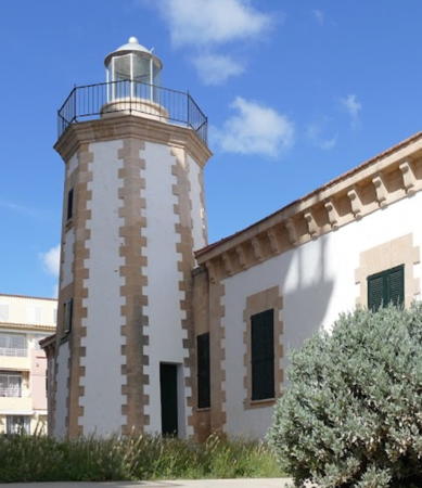
1897 (Eusebi Estada). Inactive since 1963. 8 m (26 ft) octagonal masonry tower with lantern and gallery, attached to a 1-story masonry keeper's house. Julio Manuel Merino has the 2022 photo seen at the top of this page, Pedro Perello has a 2017 photo, and Google has a street view and a satellite view. After deactivation the lantern was removed but the building served to house the port authority's aids to navigation maintenance team. In 2006 the port authority transferred the lighthouse to the city of Sant Antoni de Portmany for conversion to a maritime museum; the museum opened as the Centro de Interpretación del Mar in 2010. In 2014 a replica lantern was installed. Located at the west end of Carrer des Far in Sant Antoni de Portmany, on the west coast of Ibiza. Site open, museum open daily excpet Sundays. Owner: Ajuntament de Sant Antoni de Portmany. Site manager: Centro de Interpretación del Mar. . ARLHS BAL-096.
* San Antoni de Portmany Dique de Abrigo
Date unknown. Active; focal plane 11 m (36 ft); two red flashes every 7 s. 9 m (30 ft) post centered on a square 1-story equipment shelter. Post painted red; equipment shelter painted white with a red square on the seaward face. This light marks the north side of the entrance to the harbor of Sant Antoni de Portmany. Trabas has Andreas Köhler's photo and Google has a street view and a satellite view. Located off Carrer de Lugo, the seaside street on the north side of the harbor. Site open, tower closed. ES-32470; Admiralty E0273.3; NGA 4796.4.

Sant Joan de Labritja (North Coast) Lighthouses
Punta Moscarter (Moscarté)
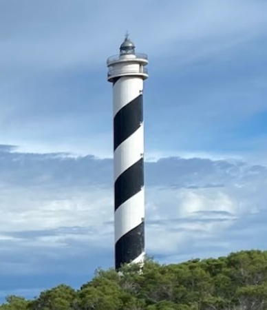
1977. Active; focal plane 93 m (305 ft); white flash every 5 s. 52 m (171 ft) round cylindrical concrete lighthouse with lantern and double gallery, painted with black and white spiral bands. Paul Geelhoedt's photo is at right, another photo is available, Geoff Graber has a more distant photo, Trabas has a view from the sea by Capt. Theo Hinrichs, and Google has a satellite view. Located at the northernmost tip of Ibiza. The lighthouse is within about 1200 m (3/4 mi) of Cala de Portinatx, and apparently it is accessible by hiking from the town along the bluffs. Site and tower closed. . ARLHS BAL-068; ES-31900; Admiralty E0270; NGA 4804.

Punta Moscarter Light, Sant Joan de Labritja, December 2022
Google Maps photo by Paul Geelhoedt
Punta Grossa
1870 (Emili Pou). Inactive since 1916. Approx. 12 m (39 ft) round stone tower attached to a 1-story stone keeper's house. Endangered: the buildings are now in ruins. Marc Mauri has a 2017 photo, Tamy Knecht has a 2018 view from above, Daniel Bruckhoff has a 2022 closeup, and Google has a satellite view. The lighthouse was difficult to reach and to supply, so it was replaced by a new lighthouse on the Isla Tagomago (next entry). With its lantern, the tower was originally 15 m (49 ft) tall. Located at the tip of a very sharp promontory at the northeastern tip of Ibiza. Accessible by a fairly strenuous hiking trail from Cala Sant Vicent. Site open, tower status unknown. .
Isla Tagomago
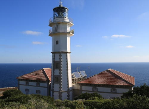
1914 (Pere Garau) (modified in 1975). Active; focal plane 86 m (282 ft); three flashes, in a 2+1 pattern, every 30 s, white or red depending on direction (red flashes are shown over a narrow sector to the southwest). 23 m (75 ft) octagonal masonry tower with lantern and double gallery, attached to two 1-story keeper's houses. Lighthouse painted white with unpainted stone trim. A 2020 photo is at right, Manuel López Gutiérrez has a great 2014 photo, a nice 2020 photo and a 2021 closeup is available, Marinas.com has good aerial photos, and Google has a satellite view. This lighthouse replaced the earlier lighthouse at Punta Grossa on the mainland (previous entry). Tagomago is an island just off the northeastern corner of Ibiza, and the lighthouse is important in guiding ships arriving in Ibiza from Mallorca. The island is privately owned and is available for rent by the week (the whole island, that is). Located on the southeastern tip of the island. Site open only to paying guests, tower closed. . ARLHS BAL-072; ES-31950; Admiralty E0268; NGA 4800.

Illa Tagomago Light, Eivissa, February 2020
Google Maps photo by EuroWeb Media

Eivissa (Ibiza) City Lighthouses
Botafoc (Islote Botafoch)
1861 (Emili Pou). Active; focal plane 31 m (102 ft); white or red light depending on direction, 5 s on, 2 s off; red light is shown over a narrow sector to the southeast. 16 m (52 ft) round masonry tower with lantern and gallery, rising from one end of a 2-story masonry keeper's house. Lighthouse painted white with unpainted stone trim; lantern is gray metallic. 2-story assistant keeper's house. A 4th order Fresnel lens installed in 1910 is now on display at Porto Pí lighthouse in Mallorca. Dudi Iskandar's 2023 photo is at right, Wikimedia has Enrique Ayesta Perojo's 2011 photo, Miguel Ramirez has a 2006 photo, a 2008 closeup photo is available, Trabas has Arndt's closeup photo, and Google has a street view and a satellite view. Fires to guide sailors were lit at this location in antiquity, and in fact "Botafoc" means "fire coming out." Located on a small islet, now connected to the mainland by a causeway, on the north side of the entrance to the harbor of Eivissa (Ibiza). The causeway is closed to the public, but there is an excellent view of the lighthouse from ferries arriving in Ibiza. Site and tower closed. . ARLHS BAL-008; ES-32050; Admiralty E0264; NGA 4808.
* Eivissa (Ibiza) Escullera (Dique de Abrigo) (2)
1915 (station established 1886). Active; focal plane 11 m (36 ft); red flash every 3 s. 11 m (36 ft) round masonry tower with lantern and gallery, rising from the center of a semicircular masonry pier house. Lighthouse painted white, lantern and gallery red. Trabas has Arndt's closeup, Rosa Franco Mendoza has a 2022 photo, Giuliano Casares has a 2019 street view of the lighthouse, Huelse has a historic postcard view, and Google has a satellite view. Located at the end of the breakwater on the south side of the harbor of Eivissa (Ibiza). Site open, tower closed. ARLHS BAL-058; ES-32070; Admiralty E0265; NGA 4820.
Isla Negra del Este
Date unknown. Active; focal plane 12 m (39 ft); red flash every 4 s. 4 m (13 ft) round concrete tower with a strongly conical base, mounted on a concrete pad. Emtire lighthouse is red. Trabas has Arndt's closeup photo and Google has a satellite view. Located on a tiny island on the west (port) side of the entrance to Ibiza harbor. Accessible only by boat, although there are views from shore. Site open, tower closed. ES-32053; Admiralty E0262.5; NGA 4811.

Botafoc Light, Eivissa, November 2023
Google Maps photo by Dudi Iskandar

Information available on lost lighthouses:

Notable faux lighthouses:

Adjoining pages: North: Catalonia | Northeast: Mallorca and Menorca | West: Valencia and Murcia

Return to the Lighthouse Directory index | Ratings key

Posted March 20, 2006. Checked and revised May 26, 2024. Lighthouses: 19. Site copyright 202 Russ Rowlett and the University of North Carolina at Chapel Hill.