Lighthouses of Brazil: North Northeast Coast

The Federative Republic of Brazil, the largest country in South America and fifth largest in the world, has a lengthy coastline, a large number of lighthouses, and a distinguished lighthouse history. Colonized by Portugal, Brazil declared its independence in 1822. Uniquely among American nations it was a monarchy as the Empire of Brazil until 1889.

Brazil is a federation of 26 states and a federal district. This page covers lighthouses along Brazil's northern coast, including the states of Maranhão, Piauí, and Ceará, the northernmost section of Brazil's Northeast Region. This is a tropical coast facing the equatorial Atlantic Ocean. The largest port is Fortaleza in Ceará, but there are several other important ports. Tourism has increased in the region in recent years and some of the major lighthouses are becoming better known.

Portuguese is the official language of Brazil. The Portuguese word for a lighthouse is farol, plural faróis. In Brazilian use the word farol generally applies to all light towers, regardless of size and whether they are enclosed structures or not. In Portuguese ilha is an island, ilhéu is an islet, cabo is a cape, ponta is a promontory or point of land, rocha is a rock, recife is a reef, baía is a bay, estreito is a strait, rio is a river, and porto is a port or harbor.

Active lighthouses in Brazil are owned by the navy (Marinha do Brasil) and maintained by the Centro de Auxílios à Navegação Almirante Moraes Rego (CAMR) in the Diretoria de Hidrografia e Navegacão (DHN). Many of the larger lighthouses are staffed by resident keepers or by rotating crews of naval personnel. Only a small number of Brazilian lighthouses are open to the public.

ARLHS numbers are from the ARLHS World List of Lights. BR numbers are from the official Brazilian Lista de Faroís. Admiralty numbers are from volume G of the Admiralty List of Lights & Fog Signals. U.S. NGA numbers are from Publication 110.

General Sources
Faroís Brasileiros
This web site for Brazilian lighthouses has small photos and historical information for many of the major lights.
Online List of Lights - Brazil
Photos by various photographers posted by Alexander Trabas.
Lighthouses in Brazil
Photos various photographers available from Wikimedia.
World of Lighthouses - Brazil
Photos by various photographers available from Lighthouses.net.
Lista de Faróis do Brasil
Index to articles on Brazilian lighthouses in the Portuguese edition of Wikipedia.
Leuchttürme Südamerikas auf historischen Postkarten
Historic postcard views posted by Klaus Huelse.
Lista de Faróis
Online version of the official Brazilian light list.
GPSNauticalCharts
Navigational chart information for the Brazilian coast.
Navionics Charts
Navigation chart for Brazil.

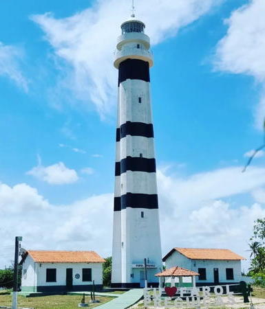
Farol de Preguiças
Preguiças Light, Maranhão, December 2008
Wikimedia Creative Commons photo by Claudinez Lacerda

Lighthouses of Maranhão

São Luís Area Lighthouses
São Luís, the capital of Maranhão, has a population of about 1.6 million. Founded by the French in 1612 as Saint-Louis, the city is located on the Ilha de São Luís in the Baía de São Marcos, an estuary that receives the outflow of several major rivers.
Ponta da Praia Grande
Date unknown (around 2000). Active; focal plane 47 m (154 ft); five white flashes, separated by 10 s, every 60 s. 45 m (148 ft) skeletal tower. No photo available but Bing has an indistinct satellite view. Note: there is another lighthouse of this name in São Paulo state. Located on a point of land about 40 km (25 mi) east of Belo. Site status unknown. BR-0494; Admiralty G0070.5; NGA 17670.
São João (Ilha Maiau, Ilha São João) (2)
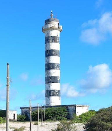
1940 (station established 1884). Active; focal plane 38 m (125 ft); white light, 2 s on, 8 s off. 30 m (98 ft) round cylindrical concrete tower, painted with black and white horizontal bands, rising from a rectangular 1-story base. Roberto Alcântara's 2022 photo is at right, a 2016 photo is available, a postage stamp also shows the lighthouse, and Google has a satellite view. Located on Ilha Maiau, an island about 25 km (15 mi) off the coast and about 210 km (130 mi) northwest of São Luís. Site status unknown. ARLHS BRA-250; BR-0496; Admiralty G0072; NGA 17672.
Mangunça
Date unknown. Active (?); focal plane 46 m (151 ft); white flash every 10 s. 40 m (131 ft) square pyramidal skeletal tower, painted white. Ariedson Almeida has a drone view and Google has a satellite view. The Admiralty has dropped its listing for this light but it remains on the 2024 Brazilian light list. Located on a promontory about 65 km (40 mi) southeast of the São João lighthouse. Site status unknown. ARLHS BRA-049; BR-0500; ex-Admiralty G0074; NGA 17676.
Pirajuba
Date unknown. Active; focal plane 64 m (210 ft); three white flashes every 15 s. 22 m (72 ft) square pyramidal skeletal tower, painted white. No photo available but Bing has a satellite view. The light was dropped by the NGA list in 2018. Located on a promontory about 30 km (19 mi) north of Alcântara. Site status unknown. ARLHS BRA-081; BR-0616; Admiralty G0078; ex-NGA 17680.
Pirarema (Alcântara)
Date unknown. Active; focal plane 55 m (180 ft); white flash every 6 s. 12 m (39 ft) octagonal masonry tower, painted white. Trabas has a view from the sea by Capt. Theo Hinrichs and Google has a satellite view of the lighthouse. Located on a promontory about 12 km (7.5 mi) north of Alcântara, across the Baia de São Marcos from São Luís. Site status unknown. ARLHS BRA-071; BR-0620; Admiralty G0079; NGA 17695.
* [Alcântara]
Date unknown. Active; focal plane 38 m (125 ft); two red f;ashes every 6 s. Approx. 5 m (17 ft) white post. Google has a street view and Google has a satellite view. Located on a bluff at the entrance to the town of Alcântara. Site open, tower closed. BR-0624; Admiralty G0080; NGA 17684.


São João Light, Ilha Maiau, May 2022
Google Maps photo by Roberto Alcântara

Itaúna (Cujupe)
Date unknown. Active; focal plane 25 m (82 ft); white flash every 5 s. Approx. 11 m (36 ft) round concrete tower with gallery, painted white. Francisco Gomes has a 2019 photo and Bing has a distant satellite view. Located on a promontory on the west side of the Baia de São Marcos about 25 km (15 mi) west southwest of São Luís. Site status unknown. BR-0628; Admiralty G0087.2; NGA 17700.
Ilha do Medo
1950. Active (?); focal plane 60 m (197 ft); three white flashes every 15 s. 31 m (102 ft) cylindrical skeletal tower mounted on a square masonry tower. No photo available but Google has a satellite view. The Admiralty has dropped its listing for this light but it remains on the Brazilian and NGA lists. Located on the highest point of an island in the Baia de São Marcos about 6 km (4 mi) southwest of São Luís. Accessible only by boat. Site status unknown. ARLHS BRA-052; BR-0640; ex-Admiralty G0087; NGA 17696.
Alumar Range Front
Date unknown. Active; focal plane 28 m (92 ft); quick white flash every 1 s. 18 m (59 ft) square white skeletal tower. No photo available but Google has a satellite view. The range guides vessels to Alumar, a commercial terminal about 20 km (13 mi) south of São Luís. Located at the entrance to the Alumar channel. Site status unknown. BR-784; Admiralty G0087.8.
Alumar Range Rear
Date unknown. Active; focal plane 30 m (98 ft); white light, 1 s on, 1 s off. 20 m (66 ft) square white skeletal tower. No photo available but Google has an indistinct satellite view. Located 120 m (394 ft) southeast of the front light. Site status unknown. BR-788; Admiralty G0087.81.
* Ponta de São Marcos (4)
Date unknown (station established 1829). Active; focal plane 36 m (118 ft); long (1.1 s) white flash every 10 s. Approx. 18 m (60 ft) round cylindrical concrete tower. Upper half of the tower originally painted red, lower half white; the entire tower has been reddish with rust in recent years. Iran Peixoto has a photo and a drone view and Google has a satellite view. The original light was an 8 m (26 ft) square masonry tower with gallery still listed by NGA; that lighthouse collapsed due to erosion in 1964. The second light, an approx. 7 m (23 ft) white concrete tower, stands near the current light. Peixoto has a 2009 photo of the third light on a tall mast. The second, third, and current lights are all seen in Google's 2015 street view. Located on the Baia de São Marcos in São Luís adjacent to the ruins of a 17th century French fort. Site open, tower closed. ARLHS BRA-191; BR-0632; Admiralty G0084; NGA 17688.
** Araçagi (Araçagy)
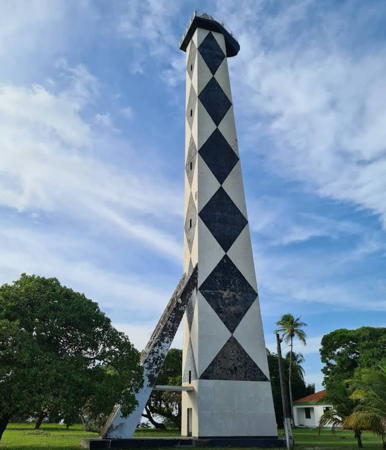
1957. Active; focal plane 91 m (299 ft); four white flashes every 10 s. 40 m (131 ft) square cylindrical concrete tower, painted in a black and white diamond pattern. A Barbier, Bénard & Turenne Fresnel lens is in use. A photo by Thiago Soares is at right, Wendell Favacho has a good photo of this stunning lighthouse, Wikimedia has a photo by Andrew Comings, an aerial photo is available, and Google has a satellite view. The two prominent braces on the rear of the tower and the boat-shaped gallery are part of the original design by AF Costa Brothers, Inc. Located just off the MA-203 coastal highway about 15 km (10 mi) northeast of São Luís. Site open, tower appears to be open as well. ARLHS BRA-005; BR-0800; Admiralty G0090; NGA List 17712.

Araçagi Light, São Luís, March 2022
Google Maps photo by Thiago Soares

Eastern Maranhão Lighthouses
#Ilha de Santana (3)
1883 (station established 1831). Inactive since 1964 and demolished, probably in early 2008. Approx. 42 m (138 ft) round cylindrical cast iron tower rising from a circular 2-story cast iron base. With its lantern the tower height was 46 m (151 ft). The first two towers (1831 and 1861) were destroyed by beach erosion but foundation ruins can be seen on the beach. According to the port captain's account the third lighthouse remained standing in the late 1990s "por uma ironia da vida" (by an irony of life). His office has a photo of the old and new lighthouses. A December 2007 aerial photo (no longer online) showed the tower partially disassembled and the demolition must have been completed soon after. Current photos are needed. ARLHS BRA-268.
* Ilha de Santana (4)
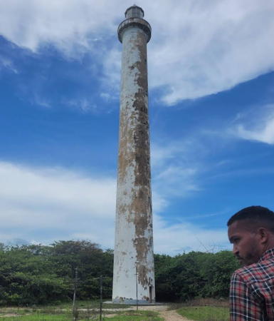
1964 (station established 1831). Active; focal plane 91 m (299 ft); light 6 s on followed by 11 s off; two white showings followed by one red. 49 m (161 ft) masonry tower with lantern and gallery, painted white. The Fresnel lens from the 1883 tower was transferred to this lighthouse. Four 1-story keeper's cottages. A 2022 photo is at right, Nelson Calmon has a 2010 closeup photo and an aerial photo, the Port Captain's aerial photo appears at right, and Google has a satellite view of the station. Located on an island at the east entrance to the Baia de São Marcos. Site open, tower closed. ARLHS BRA-050; BR-0804; Admiralty G0092; NGA 17716.
Lençóis Grandes
Date unknown. Active; focal plane 72 m (236 ft); one long (2 s) white flash every 15 s. 42 m (138 ft) square skeletal tower, painted red. No photo available but Google has a satellite view of the station. Located at the western edge of the huge Lençóis Maranhenses dune field. Site status unknown. Site manager: Parque Nacional dos Lençóis Maranhenses. ARLHS BRA-148; BR-0806; Admiralty G0093; NGA 17718.
**** Preguiças (Mandacarú) (2)
1940 (station established 1909). Active; focal plane 46 m (151 ft); white flash every 3 s. 35 m (115 ft) round cylindrical concrete tower with four ribs, lantern, and double gallery, painted white with four narrow horizontal black bands. 3rd order Fresnel lens in use. Staffed light station with two 1-story keeper's quarters. Claudinez Lacerda's photo appears at the top of this page, Bruno Soares has a fine 2018 photo, a 2015 photo is available, Wikimedia has many photos, Guilherme Carneiro has a 2019 street view, and Google has a satellite view. Sibling of the Mostardas lighthouse in Rio Grande do Sul, this lighthouse replaced a deteriorated 23 m (85 ft) skeletal lighthouse. By far the best known lighthouse of Maranhão state, the tower is at the edge of the Parque Nacional dos Lençóis Maranhenses, which preserves a vast wilderness of sand dunes and ponds. Located at Mandacarú, on the west side of the Rio Preguiça. Site open; tower open daily (and there is an elevator for those who can't climb the 160 steps). . ARLHS BRA-089; BR-0808; Admiralty G0094; NGA 17720.

Santana Light, Ilha de Santana, June 2022
Google Maps photo by Red William
* Tutóia (2)
2010(?) (station establishment date unknown). Active; focal plane 18 m (59 ft); white flash every 10 s. 12 m (39 ft) round cylindrical white concrete tower centered on a square 1-story concrete equipment shelter. A 2018 photo is available and Google has a satellite view. Ruins of the old light are on the ground in front of the new one. Located on a point of land about 10 km (6 mi) west of Tutóia. Site open, tower closed. ARLHS BRA-205; BR-0812; Admiralty G0097; NGA 17724.
* Andreza (2)
Date unknown. Active; focal plane 24 m (79 ft); red flash every 6 s. 11 m (36 ft) skeletal mast. No photo available. Google has a satellite view. Both NGA and the 2022 Brazilian list describe a pyramidal metal tower but Google's 2022 street view shows the skeletal mast. Google has a satellite view of the pyramidal tower. Located at the end of the Rua do Farol, above the beach in Tutóia. Site open, tower closed. BR-0816; Admiralty G0098; NGA 17728.

Lighthouses of Piauí

Primarily an inland state, Piauí has only a short coastline extending 66 km (41 mi) eastward from the mouth of the Parnaíba River.

*
Pedra do Sal (2)
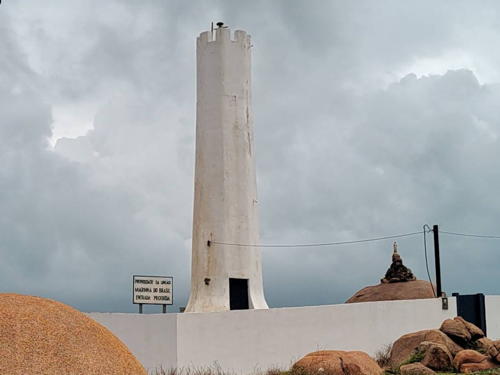
1973 (station established 1873). Active; focal plane 15 m (49 ft); white flash every 6 s. 14 m (46 ft) octagonal white concrete tower with gallery. Gabriel Rocha has a street view from the beach (also seen at right), Elisangela Fredericci has a 2021 photo, Helder Fontenele has a distant view, and Google has a street view and a satellite view. In December 2007 it was reported that a wall had been built around the lighthouse to deter vandals. Located on a rocky point north of Parnaíba, about 10 km (6 mi) southeast of the principal mouth of the Rio Parnaíba. Accessible by road. Site open, tower closed. ARLHS BRA-070; BR-0828; Admiralty G0102; NGA 17736.
Luís Correia (Ponta de Itaqui) (3)
Date unknown (station established 1917). Active; focal plane 29 m (95 ft); white flash every 5 s. Approx. 14 m (46 ft) round cylindrical fiberglass tower mounted on a square 1-story concrete equipment shelter. Lighthouse painted white with one red horizontal band. Edilson Morais Brito has a photo, André Carvalho has a drone view, Wikimedia has two distant views, and Google has a street view and a satellite view. The original lighthouse was replaced by a 20 m (66 ft) skeletal tower in 1948. Located on a promontory backed by a large dune field about 10 km (6 mi) east of the town of Luís Correia. There does not appear to be road access to this site but presumably it can be reached by 4WD along the beach. Site open, tower closed. ARLHS BRA-061; BR-0844; Admiralty G0104; NGA 17740.
 

Pedra do Sal Light, Parnaíba, December 2017
Google Maps street view by Gabriel Rocha
 

Lighthouses of Ceará

Ceará has a sandy coastline about 600 km (375 mi) long; its beaches are popular tourist attractions.

Camocim Area Lighthouses
* Ponta das Almas (Bitupitá)
Date unknown. Active; focal plane 28 m (92 ft); white flash every 10 s. 9 m (30 ft) round cylindrical white fiberglass tower. Matheus Veras has an evening photo, Yen Caballol has a sunrise photo, and Google has a street view and a satellite view. Located in the village of Bitupitá, on a sandy promontory near the western border of Ceará. Site open, tower closed. ARLHS BRA-179; BR-0848; Admiralty G0105; NGA 17744.
* Camocim (Trapiá) (3)
Date unknown (station established 1895). Active; focal plane 20 m (66 ft); three white flashes every 10 s. 15 m (49 ft) square cylindrical masonry tower painted white. Daniel Machado's photo is at right, Carlos Filho has a 2020 closeup, and Wikimedia has Otávio Nogueira's distant view. A Google street view and satellite view reveal that the neighboring keeper's house has been demolished, leaving the lighthouse alone in one corner of the walled enclosure. Although it appears to be accessible by road, this lighthouse seems to attract few visitors. Located about 5 km (3 mi) north of Camocim, a fishing port in the northwestern corner of Ceará. Site open, tower closed. ARLHS BRA-126; BR-0852; Admiralty G0108; NGA 17748.
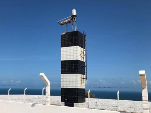
* Jericoacoara (3)
1992 (station established 1923). Active; focal plane 101 m (331 ft); white light, 2 s on, 8 s off. 6 m (20 ft) square cylindrical concrete tower covered with tiles in a pattern of black and white horizontal bands. Debora Botelho has a 2021 photo, Ariel Diacovetzky has a photo, José Ricardo Rocha has a 2017 closeup, and Google has a satellite view. Located atop a headland projecting into the sea near the popular beach resort of Jericoacoara (this headland is claimed to be the only place in Brazil where the sun both rises and sets over the sea, although there seem to be other promontories in the region where this would happen). Site open, tower closed. ARLHS BRA-059; BR-0860; Admiralty G0110; NGA 17756.
Camocin Light
Camocim Light, Camocim, December 2008
ex-Panoramio photo copyright Daniel Machado; used by permission
#Itapajé (3)
Date unknown (station established 1909). Inactive since 2015 and removed some time after July 2017. This was a 43 m (141 ft) square pyramidal steel skeletal tower, painted with black and white horizontal bands. The tower also carried a rectangular slatted daymark near the top. Google has a 2012 street view but Google's satellite view confirms the removal. The active light (focal plane 67 m (220 ft); two white flashes every 15 s) is now on a wind turbine just off the beach 2.2 km (1.38 mi) northwest. Google has a 2012 street view of the wind turbine taken before the light was installed. Michel Forand has contributed to Lighthouse Digest a postcard view of the original lighthouse, a hexagonal skeletal tower with central cylinder, lantern and gallery; it was replaced in 1933. Formerly located in what appears to be a coconut orchard beside the coastal highway about 16 km (10 mi) east of Acaraú. Site open, tower closed. ARLHS BRA-057. Current light: BR-0864; Admiralty G0114; NGA 17760.

Fortaleza Area Lighthouses
Fortaleza, the state capital of Ceará, is the fifth largest city in Brazil, with a population of about 2.7 million.

*
Mundaú (3)
Date unknown (station established 1923). Active; focal plane 33 m (108 ft); white flash every 3 s. 7 m (23 ft) square cylindrical concrete tower painted with red and white horizontal bands. Sibling of Jericoacoara. Cristiano Felix has a photo and Google has a satellite view and a distant street view. Located across the coastal road from the beach at Mundaú, about 150 km (90 mi) west of Fortaleza. Site open, tower closed. ARLHS BRA-159; BR-0868; Admiralty G0116; NGA 17764.
* Paracurú
Date unknown. Active; focal plane 80 m (252 ft); one long (1.2 s ) white flash every 10 s. 75 m (246 ft) square skeletal tower painted with red and white horizontal bands. Google has a 2018 street view. The Google satellite view shows the lighthouse standing in an industrial compound of the Brazilian energy company Petrobras. Although it is not a traditional lighthouse this is an exceptionally tall aid to navigation and a prominent landmark on the coast. Located on the Ponta Paracurú, a headland about 90 km (55 mi) west of Fortaleza. Site and tower closed, but clearly there are good views from outside the compound. ARLHS BRA-276; BR-0882; Admiralty G0117; NGA 17766.
* Pecém
Date unknown (probably recent). Active; focal plane 75 m (246 ft); flash every 10 s, two white flashes followed by one red flash. 30 m (98 ft) square pyramidal steel skeletal tower with gallery standing on a square concrete base. Lighthouse painted with red and white horizontal bands, equipment building painted white. Google has a good street view and a satellite view. Ponta Pecém is a sharp headland located about 40 km (25 mi) northwest of Fortaleza. A container ship terminal has been built off the point, with quays connected to shore by a long single-lane bridge. The lighthouse stands on heights just southwest of the terminal. Site open, tower closed. ARLHS BRA-285; BR-0884; Admiralty G0119; NGA 17766.5.
* Edifício Mansão Macêdo
Date unknown. Active (privately maintained); focal plane about 90 m (295 ft); white flash every 3 s. Light atop the Edifício Mansão Macêdo, a 24 floor condominium tower. André Almeida has a 2021 photo and Google has a satellite view. Located on the Rua Nunes Valente in downtown Fortaleza. Site open. BR-0892; Admiralty G0121.2.
Mucuripe (3)
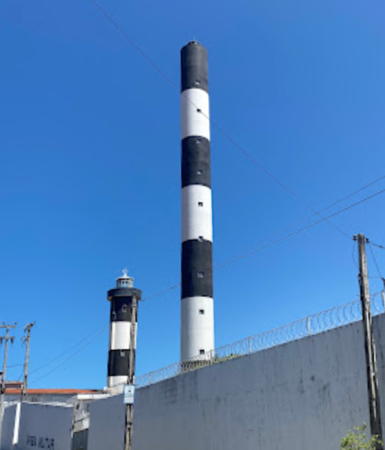
1958 (station established 1846). Inactive since 2017. 22 m (72 ft) round masonry tower with four ribs, lantern and gallery, attached to a small equipment building. The tower is wider at the top than at the bottom, but in closeup photos this makes the sides appear vertical in perspective. Lighthouse painted with black and white horizontal bands. Leonildo Ramos has the August 2017 photo seen at right, William Massari has a photo, Lightphotos.net has Robert English's view from a distance, and Google has a street view and a satellite view. Located on a ridge about 2.5 km (1.5 mi) south of the port in the Mucuripe district east of downtown Fortaleza. Site and tower closed. The tower can be seen from streets nearby, but the neighborhood of the lighthouse has been described as "unfriendly." ARLHS BRA-261.
Mucuripe (4)
2017 (station established 1846). Active; focal plane 134 m (440 ft); two white flashes every 10 s. 71 m (233 ft) round cylindrical concrete tower, painted with black and white horizontal bands. Leonildo Ramos has the August 2017 photo seen at right, Gilson Gomes has a drone view, and Google has a 2019 street view. This new lighthouse is the tallest lighthouse in the Southern Hemisphere and the tallest in the Americas. The lighthouse was activated on 18 September 2017. The new light is 45 m (148 ft) higher than the old one; this will allow the height restriction on waterfront buildings to be increased by a similar amount. Located beside the 1958 lighthouse. Site and tower closed. The tower can be seen from streets nearby, but the neighborhood of the lighthouse has been described as "unfriendly." . BR-0936; Admiralty G0122; NGA 17768.

2017 (right) and 1958 Mucuripe Lights
Fortaleza, August 2017
Google Maps photo by Leonildo Ramos
* Mucuripe (2) (Velho Farol de Fortaleza)
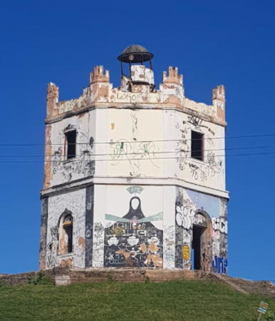
1872 (station established 1846). Inactive since 1957. Baroque 2-story hexagonal masonry building with lantern centered on the roof. Lighthouse originally painted white with yellow trim.; recently the lower half has been painted black. Dominique Greusard's photo is at right, Railtton Marques has a 2017 photo, a 2010 photo is available, Lightphotos.net has a panoramic view by Robert English, and Google has a 2022 street view and a satellite view. Endangered. Restored in 1981-82, the building was used first as a restaurant and then as a museum, the Museu do Farol. However, the museum closed in 2004 and the building is now abandoned and in need of maintenance. In the March 2016 photo the building is covered with graffiti. The situation was already more deteriorated in Robert English's 2009 photo. This is one of the oldest buildings in Fortaleza, the capital of Ceará. Located on a hilltop at the end of the Av. Vicente de Castro, near the base of the Titan Breakwater. Site open, tower closed. Owner: unknown. Owner/site manager: Prefeitura Municipal de Fortaleza. . ARLHS BRA-262.
Titan Breakwater
Date unknown. Active; focal plane 15 m (49 ft); green flash every 3 s. 12 m (39 ft) square pyramidal white fiberglass skeletal tower. Trabas has Rainer Arndt's photo, Lightphotos.net has a similar photo, and Google has a satellite view. Located at the end of the main breakwater of Fortaleza. Site and tower closed. ARLHS BRA-275; BR-0928; Admiralty G0124; NGA 17772.
Praia do Futuro
Date unknown. Active (?); focal plane 11 m (36 ft); white flash every 10 s. 6 m (20 ft) square cylindrical brick tower, painted with black and white horizontal bands. This light is on the right in a Lightphotos.net photo by Robert English and Google has a satellite view. The Admiralty has dropped its listing for this light but it remains on the Brazilian and NGA lists. Located at the end of a terminal groin projecting eastward from the Ponta do Mucuripe. Site status unknown (the groin appears walkable). BR-0932; ex-Admiralty G0123; NGA 17780.

Aracati Area Lighthouses
* Morro Branco
Date unknown. Active; focal plane 107 m (351 ft); five white flashes every 60 s. 25 m (82 ft) square masonry tower, centered on a square 1-story concrete equipment building. Entire lighthouse painted white. A 2022 photo and a distant view are available, Wikimedia has a nice view by Thiago Ogoshi, and Google has a street view and a satellite view. This lighthouse appears to be a sibling of the Farol de Camocim (above). Located atop well-known white bluffs (morro branco) about 80 km (50 mi) southeast of Fortaleza. Site open, tower closed. ARLHS BRA-260; BR-0938; Admiralty G0125.5; NGA 17802.

1872 Mucuripe Light, Fortaleza, March 2016
Wikimedia Creative Commons photo by Dominique Greusard
* Aracati (Ponta Maceió, Barra de Jaguaribe) (2)
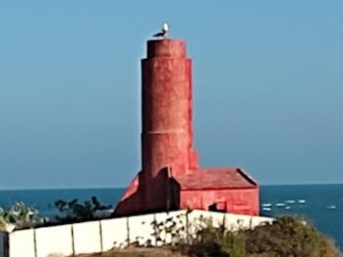
1928 (station established 1873). Active; focal plane 34 m (112 ft); white flash every 6 s. 12 m (39 ft) round masonry tower, painted red, attached to a 1-story equipment shelter. Egberto Freire has a 2016 photo, a 2021 photo is available, and Google has an indistinct satellite view. In Daniel Antonietti's 2018 photo the paint had faded to pink, but after a repainting it is bright red again in Lucas Souza's 2020 photo. This lighthouse appears to be endangered by beach erosion. Located above the beach in Aracati, on the north side of the entrance to the Rio Jaguaribe. Site open, tower closed. ARLHS BRA-006; BR-0940; Admiralty G0126; NGA 17804.
* Ponta dos Cajuais (Icapui)
Date unknown. Active; focal plane 64 m (210 ft); three white flashes every 15 s. 14 m (46 ft) round cylindrical fiberglass tower, painted with red and white horizontal bands. Joserley C. de Souza has a closeup photo and Google has a street view and a satellite view. Located about 4 km (2.5 mi) from the beach in Icapui, marking a prominent bulge in the coastline. Site open, tower closed. ARLHS BRA-072; BR-0944; Admiralty G0148; NGA 17808.

Information available on lost lighthouses:

Notable faux lighthouses:

Adjoining pages: North: Northern Brazil | East: Northeastern Brazil | South: Bahia

Return to the Lighthouse Directory index | Ratings key

Posted February 16, 2004. Checked and revised May 17, 2023. Lighthouses: 34. Site copyright 2023 Russ Rowlett and the University of North Carolina at Chapel Hill.