Lighthouses of the United States: Oregon

The United States of America is a federal union of 50 states and a capital district. The west coast state of Oregon is located on the Pacific coast north of California. Oregon was originally part of the Oregon Country, the area west of the Continental Divide between latitudes 42° and 54°40' North. In the London Convention of 1818 the U.S. and Britain agreed to joint occupation of this territory. The Oregon Treaty of 1846 confirmed British occupation of Vancouver Island and the rest of what became British Columbia; it also set the boundary between the U.S. and British territory at latitude 49° between the Rocky Mountains and the Strait of Georgia. In 1853 the Oregon Territory was divided, the part north of the Columbia River becoming Washington Territory, and in 1859 Oregon, the area south of the Columbia, was admitted to the Union as the 33rd state.

Almost all of Oregon's 363 mi (584 km) of coastline is steep and scenic, and the lighthouses are generally built on spectacular headlands. Protected harbors are very scarce. The most important harbor facilities are on the Columbia River, which forms the northern border of the state. In all there are 12 lighthouses, two of them built privately. In addition the lightship Columbia is preserved at Astoria.

The Oregon Chapter of the U.S. Lighthouse Society supports all the state's lighthouses and there are local preservation groups active at many of them.

Navigational aids in the United States are operated by the U.S. Coast Guard but ownership (and sometimes operation) of historic lighthouses has been transferred to local authorities and preservation organizations in many cases. Aids to navigation in Oregon are maintained by the Thirteenth Coast Guard District. Aids to Navigation (ANT) teams are based at Coos Bay and Astoria.

ARLHS numbers are from the ARLHS World List of Lights. Admiralty numbers are from Volume G of the Admiralty List of Lights & Fog Signals. USCG numbers are from volume 6 of the U.S. Coast Guard List of Lights.

General Sources
Oregon Lighthouses
From Kraig Anderson, excellent photos and historical accounts.
Online List of Lights - U.S. West Coast
Photos by various photographers posted by Alexander Trabas. Many of the Oregon photos are by Selector Jonathon Photography (SJP).
Lighthouses in Oregon
Photos by various photographers available from Wikimedia.
World of Lighthouses - Northwest Coast of U.S.
Photos by various photographers available from Lightphotos.net.
Oregon, United States Lighthouses
Aerial photos posted by Marinas.com.
Leuchttürme USA auf historischen Postkarten
Historic postcard images posted by Klaus Huelse.
U.S. Coast Guard Navigation Center: Light Lists
The USCG Light List can be downloaded in pdf format.
NOAA Nautical Charts
Official nautical charts for the coast can be viewed online.
Navionics Charts
Navigation chart for Oregon.


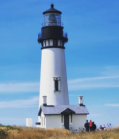
Yaquina Head Light, Newport, August 2014
Wikimedia public domain photo by Bureau of Land Management

Curry County Lighthouses
Pelican Bay (Port of Brookings)
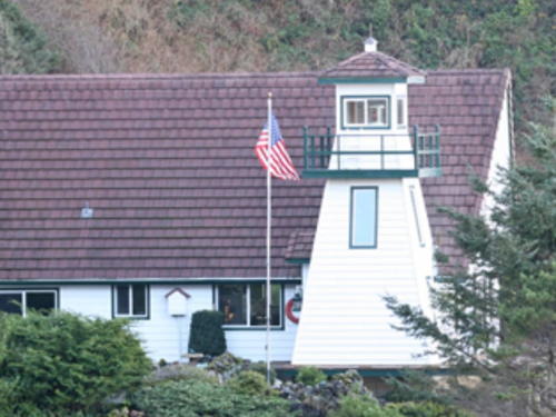
1999. Active (privately maintained); focal plane 141 ft (43 m); three white flashes every 19.5 s. 40 ft (12 m) octagonal wood tower attached to a 2-story wood residence. Lighthouse painted white, lantern black. Acrylic Fresnel lens. Trabas has an excellent photo by Michael Boucher, Elise Suarez has a 2020 photo, a 2009 photo is available, Marinas.com has aerial photos, and Google has a satellite view and a distant street view. The house was built by Bill and JoAnn Cady in 1990, but it only became a working lighthouse after both house and tower were relocated to their present location in 1997. With Coast Guard approval the light was activated on Independence Day (4 July) 1999. Located on a bluff off Oceanside Drive and above the Beachfront Inn in Harbor, about 1/2 mi (800 m) southeast of the harbor entrance. Site and tower closed (private residence). Owner/operator/site manager: private. ARLHS USA-1005; Admiralty G4423; USCG 6-0570.
* Chetco River Range Rear
Date unknown. Active; focal plane 65 ft (20 m); red light, 3 s on, 3 s off. Approx. 18 m (59 ft) square cylindrical skeletal tower carrying a rectangular daymark painted red with a black vertical stripe. Google has a street view and a satellite view. The front light is on a shorter skeletal tower. Located beside Lower Harbor Road at the Port of Brookings Harbor. Site open, tower closed. Owner/operator: U.S. Coast Guard. Admiralty G4424.1; USCG 6-8615.
* Cape Blanco
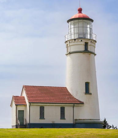
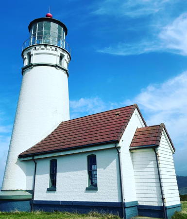
1870. Active; focal plane 245 ft (75 m); white flash every 20 s, day and night. 59 ft (18 m) brick tower attached to a workroom. The lighthouse has an unusual rotating Henry LePaute Fresnel lens (1936), larger than 2nd order but smaller than 1st order. Lighthouse painted white with black trim; lantern roof is red. The keeper's house has been demolished but there is a modern visitor center. A photo is at right, Anderson has an excellent page for the lighthouse, Trabas has a good photo by SJP, Wikimedia has photos, Joey Rozier has a closeup street view, Marinas.com has aerial photos, Huelse has a historic postcard view, and Google has a satellite view. This is Oregon's oldest and westernmost lighthouse. The lens was removed, restored, and reinstalled in 2002. In 2003 the Bureau of Land Management carried out a $220,000 restoration of the lens and lighthouse; $40,000 of the cost was covered by visitors' donations. The Cape Blanco Heritage Society works for maintenance of the light station. The light station is adjacent to Cape Blanco State Park (camping available); volunteer docents at the lighthouse receive a free campsite and hook-up. Located at the end of Cape Blanco Road about 5 miles (8 km) northwest of Sixes. In early 2022 the lighthouse was closed due to a need for interior repairs. It remains closed but the visitor center and gift shop are open in season. Site open, tower closed. Owner: U.S. Coast Guard. Site manager: U.S. Bureau of Land Management and Cape Blanco Heritage Society (Cape Blanco Light Station ). ARLHS USA-107; Admiralty G4432; USCG 6-0595.
Cape Blanco Light
Cape Blanco Light, Port Orford, June 2006
Flickr Creative Commons photo by redgum

Coos County Lighthouses
* Coquille River Entrance (South Jetty)
Date unknown. Active; focal plane 30 ft (9 m); red flash every 4 s. 20 ft (6 m ) mast and fog signal atop a square cinder block equipment shelter; the mast carries a triangular red daymark. Fog horn (blast every 30 s). Trabas has Michael Boucher's photo, Joey Rozier has a street view, and Google has a satellite view. The jetty is not easily walkable but the light can be seen from shore. Site open, tower closed. Admiralty G4441; USCG 6-8700.
* Coquille River Entrance Range Rear
Date unknown. Active; focal plane 46 ft (14 m); white light, 3 s on, 3 s off. 43 ft (13 m) square cylindrical skeletal tower carrying a rectangular daymark colored red with a black vertical stripe. Trabas has Boucher's photo and Google has a street view and a satellite view. Located on Riverside Drive just east of the marina in Bandon. The front light is on a similar but shorter tower located on the marina breakwater. Site open, tower closed. Admiralty G4438.1; USCG 6-8695.
*** Coquille River (Bandon)
1896 (Carl Leick). Inactive since 1939 (a decorative solar-powered light has been displayed since 1991; charted as a landmark). 40 ft (12 m) stucco-clad brick tower attached to an unusual "Victorian Italianate" fog signal building. Lighthouse painted white, lantern and gallery black. The keeper's house has been demolished. Jim Getchell's photo is at right, Marissa Burden-Dyke has a 2021 photo, Chris Carr has a 2008 photo, Wikimedia has photos, Marinas.com has aerial photos, Jeff Downing has a 2015 street view, and Google has a satellite view. The Coast Guard has a small historic photo of the complete station. Lighthouse Digest covered the 100th anniversary of the light station in 1996. The lighthouse was restored beginning in 1976 by Oregon State Parks. However, violent weather in the early 2000s damaged the site and a new restoration effort was launched. Progress was slow, however, and in 2005 there was fresh concern about the poor condition of the building. Restoration was finally completed by Oregon State Parks in 2007; a July 2007 photo by Dennis Fones shows the work in progress. In 2010-11 there was additional work to replace the windows in the lighthouse. Located at the end of Park Road, off US 101 on the north side of the river entrance opposite Bandon. Site open, fog signal building open Thursday through Monday mid-May through September (free); tower closed. Owner: Oregon State Parks. Site manager: Bullard's Beach State Park. . ARLHS USA-194.

Coquille River Light, Bandon, August 2014
Wikimedia Creative Commons photo by Jim Getchell
Cape Arago (Cape Gregory) (3)
1934 (station established 1866). Inactive since 2006. 44 ft (13.5 m) octagonal cylindrical concrete tower attached to a 1-story concrete fog signal building; solar-powered VRB-25 aerobeacon. Lighthouse painted white, lantern black; roofs of the building and the lantern are red. Sibling of the Point Robinson Light in Washington. The original 4th order Fresnel lens, removed in 1993 and formerly stored at the North Bend Coast Guard Station, was installed at the Coos History Museum in April 2016. NOAA C-MAN automatic weather station. Jim Getchell's photo is at right, Dave Ortman has a 2016 photo, a 2008 photo is available, Wikimedia has photos, Marinas.com has aerial photos, Huelse has a historic postcard view, Erik Sundell has a distant street view from the beach at Sunset Bay, and Google has a satellite view. This lighthouse replaced a 1908 building that remained in use as the keeper's house until it was demolished in 1957. The building was painted and repaired in 1998, but the light was deactivated on New Year's Day 2006. Local Indian tribal groups have been maintaining the lighthouse grounds and have expressed interest in working with other local groups to restore and reactivate the lighthouse. In 2008 Congress passed an act transferring the light station to the Confederated Tribes of Coos, Lower Umpqua and Siuslaw Indians. The transfer took place in August 2013. The historic (1889) footbridge to the island has been removed to deter vandals. Located on Chief's Island just off the coast about 3 miles (5 km) west of Charleston and 2 miles (3 km) north of the actual cape. Visible from an overlook on the Cape Arago highway west of Charleston. The shoreline opposite the lighthouse is accessible by a rugged foot trail connecting Sunset Bay State Park and Cape Arago State Park (camping available). Site and tower closed. Owner/site manager: Confederated Tribes of Coos, Lower Umpqua, and Siuslaw Indians. . ARLHS USA-106; ex-Admiralty G4450; ex-USCG 6-0605.

Cape Arago Light, Charleston, September 2014
Wikimedia Creative Commons photo by Jim Getchell
Coos Bay Inside Range A Rear
Date unknown. Active; focal plane 50 ft (15 m); red light, 3 s on, 3 s off. 50 ft (15 m) square cylindrical skeletal tower carrying a rectangular daymark painted red with a black vertical stripe and mounted a platform supported by piles. Tracy Pitts has a distant view and Google has a satellite view. The range guides vessels southbound toward the entrance. Located in the bay just off the north side of the Charleston Marina. Accessible only by boat, but easy to see from shore. Site open, tower closed. Admiralty G4456.1; USCG 6-8790.
Coos Bay Entrance Range Rear
Date unknown. Active; focal plane 64 ft (19.5 m); red light, 3 s on, 3 s off. 64 ft (19.5 m) square cylindrical skeletal tower carrying a rectangular daymark painted red with a black vertical stripe and mounted a platform supported by piles. No photo available but Google has a satellite view. Located in the bay just off the east side of the Charleston Marina. Accessible only by boat, but easy to see from shore. Site open, tower closed. Admiralty G4455.9; USCG 6-8745.

Douglas County Lighthouse
**** Umpqua River (2)
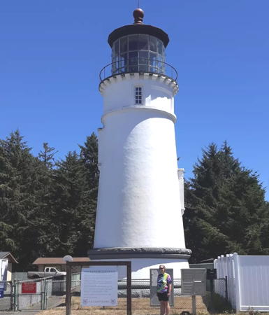
1894 (station established 1857 but inactive 1864-1894). Active (maintained by Douglas County); focal plane 165 ft (50 m); flashes every 5 s, two white flashes and then one red flash, day and night. 65 ft (20 m) stucco-clad brick tower attached to a workroom; the original F. Barbier 1st order Fresnel lens is still in use. Lighthouse painted white; lantern roof is red. The original keeper's house has been demolished but the former Umpqua River Coast Guard Station now serves as the Coastal Visitor Center and lighthouse museum. This is Oregon's oldest light station. The lighthouse is a sibling of Heceta Head Light but both these light towers are similar to the much earlier Cape Blanco Light. Bill Britten has excellent photos showing the unusual red and clear prisms of the lens, Anderson has an excellent web page for the lighthouse, Trabas has a closeup by SJP, a 2021 photo is available, Marinas.com has aerial photos, Huelse has a historic postcard view, and Google has a 2016 street view and a satellite view. Public protests saved the lens when the revolving mechanism broke down in 1983. In 2005 the Jeld-Wen Company donated badly needed new doors and windows. In 2007 Senator Gordon Smith introduced legislation to transfer ownership of the lighthouse to Douglas County; previously the county held a lease on the station. The lighthouse was restored during an 18-month project in 2007-08 and reopened on May 1, 2008. In 2010 the Coast Guard proposed deactivating the light and removing the lens, a move opposed by local residents. In December the Coast Guard agreed to continue the light, provided Douglas County assumed the maintenance costs; the county agreed to this arrangement. A formal agreement was signed in March 2012 and the county took ownership of the lighthouse and lens on 12 May. The 125th anniversary of the lighthouse was celebrated on New Year's Eve 2019. The lighthouse was repainted in 2020. In 2023 a gallery for local artisans opened in a neighboring former Coast Guard barracks. The light station is adjacent to Umpqua Lighthouse State Park (camping available). Located off US 101 about 1 mile (1.5 km) south of Winchester Bay, on the south side of the river entrance. Site open (free), tours including the tower daily year round (modest admission fee). Owner: Douglas County. Site manager: Douglas County Parks and Umpqua Valley Museums (Umpqua River Lighthouse) . ARLHS USA-866; Admiralty G4472; USCG 6-0620.
Umpqua River Light
Umpqua River Light, Winchester Bay, October 2008
Flickr Creative Commons photo by Justin Miller

Lane County Lighthouses
Siuslaw River Range Rear
Date unknown. Active; focal plane 61 ft (19 m); red light, 3 s on, 3 s off. Approx. 56 ft (17 m) square cylindrical skeletal tower carrying a rectangular daymark painted red with a black vertical stripe. Google has a street view and a satellite view. Located in a forest off North Jetty Road in Heceta Beach. Site status unknown. Admiralty G4480.1; USCG 6-9445.
**** Heceta Head
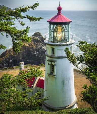
1894. Active (maintained by Oregon State Parks); focal plane 205 ft (62.5 m); white flash every 10 s, day and night. 56 ft (17 m) stucco-clad brick tower attached to workroom; the original Chance Brothers 1st order Fresnel lens is still in use. Lighthouse painted white; lantern roof is red. The original 2-story Queen Anne-style wood keeper's house, known as Heceta House, is now used as a bed and breakfast inn . Two oil houses and a barn are also preserved; one of the oil houses is used as a generator house. Surely one of the most dramatically beautiful light stations of the world, high above the Pacific and surrounded by the Siuslaw National Forest. A photo is at right, Anderson has a fine page for the lighthouse, John Harrison has a 2019 photo of the light in action, Trabas has SJP's photo, the Coast Guard has a 1951 aerial photo, Marinas.com has aerial photos, Huelse has a postcard photo, Tim Groce has a 2016 street view, and Google has a satellite view. In 2000 the Coast Guard proposed to abandon use of the first-order lens after the rotating mechanism broke down. A compromise was worked out to restore the lens, and in February 2001 it was carefully dismantled, restored and cleaned. Lighthouse Digest has an October 2001 article on the project. The light was relit on June 16. As part of the compromise ownership of the lighthouse was transferred to Oregon State Parks. In February 2009 state officials shut down the lighthouse due to another failure of the rotating mechanism. After $22,000 in repairs the lighthouse was back in operation in late May. A major restoration costing about $1.3 million began early in 2012. The lighthouse reopened in June 2013. In summer 2018 the lighthouse was closed for repairs to cracked metal columns in the interior. The 125th anniversary of the lighthouse was celebrated in March 2019. Later in 2019 a new preservation organization was founded, the Keepers of Heceta Head Lightstation . Note: Heceta is pronounced "ha-see-ta." Located off US 101 about 15 miles (25 km) north of Florence. Accessible by a 1/2 mi (800 m) Forest Service hiking trail from a state park parking area (annual permit or $5 day use admission). Site open (park entry fee), interpretive center open daily except Wednesdays from Memorial Day weekend (late May) through Labor Day (early September); the ground floor of the lighthouse is open daily (if staff is available and weather permits) daily in the summer and Friday through Monday in the winter. Owner: Oregon State Parks (lighthouse) and U.S. Forest Service (keeper's house). Site manager: Heceta Head Lighthouse State Scenic Viewpoint. . ARLHS USA-368; Admiralty G4486; USCG 6-0635.

Heceta Head Light, Florence, June 2009
Flickr Creative Commons photo by CAJC: in the PNW

Lincoln County (Newport Area) Lighthouses
Cleft of the Rock (Cape Perpetua)
1976. Inactive since 2016. 35 ft (11 m) square pyramidal wood tower with lantern and gallery, attached to a 2-story A-frame residence. Lighthouse painted white with buff trim. G.E. Bauer has a photo, Trabas has a closeup by Klaus Potschien, and Google has a satellite view. The lighthouse is a replica of the 1898 Fiddle Reef Light on Vancouver Island, Canada; the acrylic lens is from the Solander Island Light, off the west coast of Vancouver Island. The lighthouse was built by author Jim Gibbs (former keeper at Tillamook Reef Light) and was accepted by the Coast Guard as a privately maintained aid to navigation. Gibbs passed away in May 2010 but his daughter and her husband owned the house and kept the light in service for several years. It was dropped from the USCG List in 2016; in that year the lighthouse was listed for sale. It sold in June 2017 for $489,900. In 2023 it was back on the market, this time for $2.25 million. It's remarkable that this prominent headland never had an official lighthouse. Located just off US 101 at Cape Perpetua (milepost 166), about 2 miles (3 km) south of Yachats. Site and tower closed (private residence), but there's a good view from the shoulder of US 101 nearby. Owner/site manager: private. ARLHS USA-964; ex-Admiralty G4487; ex-USCG 6-0640.
Yaquina Bay Entrance Range Rear
Date unknown. Active; focal plane 52 ft (16 m); red light, 3 s on, 3 s off. 52 ft (16 m) square cylindrical skeletal tower carrying a rectangular daymark painted red with a black vertical stripe and mounted on a square platform supported by piles. Trabas has SJP's photo, Nathan Adam has a street view, and Google has a satellite view. Located in the bay on the west side of the US 101 bridge. Accessible only by boat. Site open, tower closed. Admiralty G4490.1; USCG 6-9585.
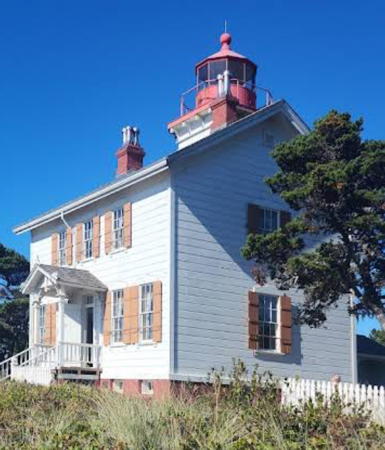
**** Yaquina Bay
1871. Reactivated (inactive 1874-1996, now privately maintained); focal plane 165 ft (50 m); continuous white light. 51 ft (16 m) square cylindrical wood tower mounted on the roof of a 2-story wood keeper's house; 250 mm lens. Building painted white with red trim; lantern and gallery are painted bright red. Larry Myhre's photo is at right, Anderson has a fine page with several good photos, a 2022 photo is available, Bill Britten has a good photo, Trabas has a photo by SJP, the University of Oregon Library has a historic photo, Marinas.com has distant aerial photos, Denise Barlock has a street view, Kyle Kunze has a more distant street view from the beach, and Google has a satellite view. Though it served only briefly as a lighthouse the building was a lifesaving station for many years. Friends of Yaquina Lighthouses worked for its restoration and reactivation. Believed to be the oldest building in Newport, the lighthouse is now a museum. Lighthouse painted in 2000. Lighthouse Digest has a November 2005 article on the history of the station. Located on the north side of the Yaquina Bay entrance in Newport, just off US 101; Site open, museum and tower open daily year round (free, donations requested). Group tours can be arranged and the lighthouse is a popular site for weddings. Parking is at the viewpoint parking lot below the lighthouse; a long stairway leads to the lighthouse. Owner: Oregon State Parks (Yaquina Bay State Recreation Area). Site manager: Friends ofYaquina Lighthouses . ARLHS USA-906; Admiralty G4490.2; USCG 6-9613.
Yaquina Bay Light
Yaquina Bay Light, Newport, May 2006
Flickr Creative Commons photo by Larry Myhre
**** Yaquina Head
1873. Active; focal plane 162 ft (49 m); two white flashes every 20 s, flashes separated by 2 s, day and night. 93 ft (28 m) brick tower attached to a 1-story brick oil house. The original Barbier & Fenestre 1st order Fresnel lens (1868) is still in use. Tower painted white, lantern black, lantern roof red. Sibling of the Pigeon Point lighthouse in Northern California. The original principal keeper's house was demolished in 1938, but the assistant keeper's house, two more modern keeper's houses (1922 and 1938), oil house (1889), barn (1886), stable, and other light station buildings are preserved. A photo is at the top of this page, Anderson has photos and historical information, Stephanie Scott has a 2021 photo, Larry Eiring has a good closeup photo, Michael Overstreet has a 2014 street view, Trabas has SJP's photo, the University of Oregon Library has a historic photo taken in the 1890s, Huelse has a historic postcard view, and Google has a satellite view. This is a classic: one of the best known and most often visited lighthouses of the Pacific Northwest, and also the tallest Oregon lighthouse. The Coast Guard transferred ownership to the Bureau of Land Managenemnt in 1993. In 2005-06 a $1 million appropriation from Congress funded a thorough restoration of the lens and lighthouse; Lighthouse Digest has a March 2006 article describing this project. The restoration was completed in June 2006. In October 2014 the lighthouse closed for three months for repainting and exterior repairs. Site open (entry fee to area), tower normally open daily. Located at the end of Lighthouse Drive off US 101 in Agate Beach, 2 miles (3 km) north of Newport. Accessible by a short walk from the parking area at the end of the road. Owner: U.S. Bureau of Land Management. Site manager: Yaquina Head Outstanding Natural Area and Friends ofYaquina Lighthouses . ARLHS USA-907; Admiralty G4506; USCG 6-0650.

Tillamook County Lighthouses
*** Cape Meares (1)
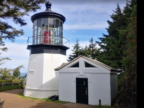
1890. Inactive since 1963. 40 ft (12 m) octagonal tower, brick sheathed in iron, attached to a workroom. Tower painted white, lantern black. The original 1st order Fresnel lens, vandalized after the lighthouse was decommissioned, was partially restored and is still mounted in the tower (one of the four bullseye prisms is missing). The keeper's house and other light station buildings were all demolished around 1968 after severe vandalism. The visitor center is a reconstruction (1978) of the original workroom. A 2021 photo is at right, David Grant has a closeup photo, Anderson has a fine page for the lighthouse with several photos, Bill Britten has great photos, Marinas.com has aerial photos, Huelse has a historic postcard view, a 1955 photo is available, and Google has a street view and a satellite view. In 2003 Oregon State Parks carried out a $310,000 restoration of the lighthouse. Friends of Cape Meares Lighthouse supports the light station. In January 2010 vandals fired shots into the lighthouse, breaking windows and damaging several prisms of the lens. Two men were arrested and charged with felony mischief. Damage was estimated at $500,000. In December the two men agreed to pay $100,000 in restitution. The lighthouse was repainted in 2018. Located on a bluff about 200 ft (60 m) above the ocean at the end of Lighthouse Road about 6 miles (10 km) northwest of Tillamook. Accessible by a short walk from the parking area at the end of the road. Site open daily April 1 through October 31; the base of the tower is open daily May through September and tours of the upper levels are often available. Owner/site manager: Oregon State Parks (Cape Meares State Scenic Viewpoint). . ARLHS USA-128.
* Cape Meares (2)
1963. Inactive since 2014. 17 ft (5 m) 1-story cinderblock building with the light mounted on a short post. Google has a street view. The light was deactivated in June 2014. Located a few feet from the historic lighthouse. Site open, tower closed. Owner: U.S. Coast Guard (?). ex-Admiralty G4516; ex-USCG 6-0675.

Cape Meares Light, Tillamook, June 2021
Google Maps photo by Trachemysta

Clatsop County Lighthouses
Tillamook Rock
1881 (George Ballantyne). Inactive since 1957. 62 ft (19 m) square cylindrical brick tower atop 1-story brick keeper's house. Lighthouse painted white, lantern and watch room black. The original 1st order Fresnel lens, removed in 1935, was donated to the University of Oregon where it was lost in a warehouse fire. Zach Wolf's 2018 photo is at right, Lighthouse Digest has Richard Clayton's story on the history of the light station, Eric Person has a view from the sea, Stuart Wolf has a 2018 drone view, Huelse has a historic postcard view, and Google has a satellite view. Endangered, and a longtime resident on the Lighthouse Digest Doomsday List. After deactivation in 1957 the lighthouse was sold to absentee owners in 1959, 1973, and 1978. In 1980 the lighthouse was purchased and gutted inside with the idea of making it a columbarium, a repository for the ashes of the deceased. However, access problems prevented the owners from carrying out this plan properly and in 1999 the state of Oregon's Mortuary and Cemetery Board canceled the group's license. In recent years the lighthouse has appeared to be abandoned but the owners said they intended to continue the original plan with new funding. Instead they placed it on sale for $6.5 million in 2022, still describing it as a columbarium. This is one of the most inaccessible of all U.S. lighthouses, located on a rock in tumultuous seas about 1 mile (1.5 km) off Tillamook Head and 6 miles (10 km) southwest of Seaside. Visible distantly from Ecola State Park north of Cannon Beach. Site and tower closed. Owner/site manager: Tillamook Rock Lighthouse . ARLHS USA-849.
[Columbia River Approach Lightfloat]
Date unknown. Active; alternating short and long white flashes; whistle. Approx. 25 ft (7.5 m) square skeletal tower on a round lightfloat, painted with red and white stripes. The tower also carries a racon (radar transceiver). Mark Whitaker has a photo. This lightfloat replaces the former lightship Columbia, now moored at Astoria (see below). Located southwest of the mouth of the Columbia River marking the beginning of the approach. Accessible only by boat. Site open, structure closed. USCG 6-0690.

Tillamook Rock Light, Tillamook, September 2018
ex-Google Plus photo by Zach Wolf
Sand Island Range Rear
Date unknown. Active; focal plane 64 ft (19.5 m); green light, 3 s on, 3 s off. 64 ft (19.5 m) square cylindrical skeletal tower mounted on a platform supported by piles; the tower carries a rectangular daymark painted red with a black vertical stripe. No photo available but Google has a satellite view. This is the second range for vessels entering the Columbia River. The front light is on a similar tower 41 ft (12.5 m) tall. Located north of Sand Island in Baker Bay, an old channel of the Columbia River north of the present channel. Accessible only by boat. Site open, tower closed. Admiralty G4535.1; USCG 6-9950.
[Desdemona Sands (3)]
Date unknown (station established 1905). Active; focal plane 23 ft (7 m); white flash every 4 s. 23 ft (7 m) post mounted on a small platform supported by piles. Trabas has Jim Smith's photo and Google has a satellite view. Desdemona Sands is a large shoal just inside of the mouth of the Columbia River. The original lighthouse had a lantern atop a 2-story keeper's house mounted on a large platform supported by numerous piles. Anderson also has a page for the lighthouse with historic photos. The lighthouse was demolished in 1942 but its Fresnel lens is on display at the Mukilteo Lighthouse in Washington and its fog bell is on display at the Columbia River Maritime Museum in Astoria. A lightbeacon stood on the platform until 1964 when the entire structure was removed. Located on the western tip of the shoal. Accessible only by boat. Site open, tower closed. ARLHS USA-982; Admiralty G4564; USCG 6-9995.
**** Lightship WLV 604 Columbia
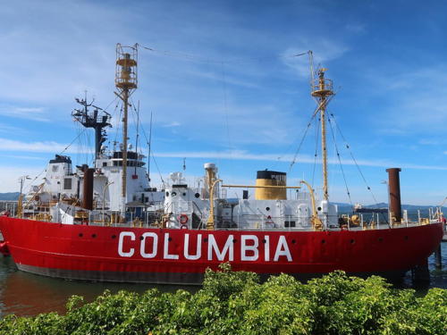
1950. Decommissioned 1979. 617-ton 2-masted steel lightship, length 128 ft (39.0 m), beam 30 ft (9.1 m). Vessel painted red, superstructure white, masts and stack buff. Neal Wellons's photo is at right, Tim Horvath has a 2023 photo, Josh Kaiser has a 2014 photo, a 2010 photo is available, and Google has a 2019 street view and a satellite view. Most lightships serve several stations during their careers, but WLV 604 served its entire career on the Columbia station off the mouth of the Columbia River. One of the best preserved U.S. lightships, it is operational. After deactivation it was acquired by the Columbia River Maritime Museum in Astoria, where it has been on display ever since. The large (40 ft diameter) buoy that replaced the lightship from 1979 to 1993 was on display, floating next to the ship; it was removed sometime after 2008 but later returned. In 2020 the museum was raising $1.1 million needed for a restoration of the ship. In October 2021 the ship was towed to Portland for repairs and restoration; the engine room and other below-decks areas were to be restored. The ship returned to the museum in June 2022. In late December 2022 storm-driven high tides destroyed the ship's gangway; federal funds were requested in February 2023 for its replacement. The ship was moved to Tongue Point pending replacement of the gangway and some repairs to the ship. The ship has now returned. Moored at the Columbia River Maritime Museum on US 30 (Marine Drive) near 17th Street in downtown Astoria. Site and museum open daily, the ship is open to guided tours from the museum. Owner/site manager: Columbia River Maritime Museum. . ARLHS USA-184.

Lightship WLV 604 Columbia, Astoria, March 2015
Flickr Creative Commons photo by Neal Wellons
Tongue Point Channel Range Rear
Date unknown. Active; focal plane 62 ft (19 m); red light, 3 s on, 3 s off, visible only along the range line. 62 ft (19 m) square skeletal tower mounted on a platform supported by piles; the tower carries a rectangular daymark painted red with a black vertical stripe. No photo available but Google has a satellite view. This range guides vessels downstream (westward) through a difficult passage in the Columbia estuary. Located about 6 mi (10 km ) east northeast of Astoria. Accessible only by boat. Site open, tower closed. Admiralty G4603.1; USCG 6-10187.
Pillar Rock Lower Range Rear
Date unknown. Active; focal plane 79 ft (24 m); white light, 3 s on, 3 s off, visible only along and near the range line. 79 ft (24 m) square cylindrical skeletal tower mounted on a platform supported by piles; the tower carries a rectangular daymark painted red with a black vertical stripe. No photo available but Google has a satellite view. This range guides vessels upstream (eastward). Located about 16 mi (26 km ) east northeast of Astoria. Accessible only by boat. Site open, tower closed. Admiralty G4608.1; USCG 6-10240.
Pillar Rock Upper Range Rear
Date unknown. Active; focal plane 58 ft (18 m); red light, 3 s on, 3 s off, visible only along and near the range line. 58 ft (18 m) square cylindrical skeletal tower mounted on a platform supported by piles; the tower carries a rectangular daymark painted red with a black vertical stripe. No photo available but Google has a satellite view. This range guides vessels upstream (eastward). Located about 2 mi (3 km ) east of the lower range rear light. Accessible only by boat. Site open, tower closed. Admiralty G4610.1; USCG 6-10280.
Wauna Range Rear
Date unknown. Active; focal plane 63 ft (19 m); red light, 3 s on, 3 s off, visible only to eastbound vessels. 63 ft (19 m) square cylindrical skeletal tower mounted on a platform supported by piles; the tower carries a rectangular daymark painted red with a black vertical stripe. G. Kim Taylor has a 2021 photo and Google has a satellite view. This range guides vessels upstream (eastward) on a long southeast reach. Located on the south side of the river and the east side of the entrance to Westport. Accessible only by boat but there is a good view from ferries between Westport, Oregon, and Cathlamet, Washington. Site open, tower closed. Admiralty G4625.1; USCG 6-10435.

Columbia County Lighthouse
Warrior Rock (2)
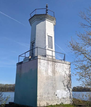
1931 (station established 1889). Active; focal plane 28 ft (9 m); white flash every 4 s. 25 ft (8 m) octagonal concrete tower mounted on the original square sandstone foundation. Entire structure painted white. The lighthouse was repaired in 1969 after being seriously damaged in a collison with a barge. Ruins of the original keeper's house (basement and chimney) are nearby, hidden by forest; the house burned sometime in the early 1990s. The historic fog bell (1855, previously used at Cape Disappointment and West Point, Washington) is on display at the Columbia County Courthouse in St. Helens. There is a half-size replica of the 1889 lighthouse behind the older courthouse, nearby; Google has a street view. A photo is at right, Eric Kuschner has a photo, Michael Jones has a 2021 photo, Jenn Sinclair has a 2007 closeup photo, Trabas has Jim Smith's photo, Wikipedia has a page with a good photo, the Sauvie Island Community Association also has a page, the owners of the surrounding land have a page, Philip Modin has a 2016 street view, and Google has a satellite view. At one time the city of St. Helens hoped to start water taxi service to the area of the lighthouse, with hiking trails and historical markers adjacent to the building, but none of this seems to have happened. Located on the northeastern tip of Sauvie Island, in the Columbia River south of St. Helens. The island is accessible by bridge from US 30 near Burlington; the lighthouse is accessible by a 3 mile (5 km) hike from the end of Reeder Road or by a short boat ride from the marina in St. Helens. Site open, tower closed. Site manager: U.S. Coast Guard. . ARLHS USA-977; Admiralty G4687.4; USCG 6-11060.

Warrior Rock Light, St. Helens, June 2016
Instagram photo by einwandervogel

Information available on lost lighthouses:

Notable faux lighthouses:

Adjoining pages: North: Western Washington | South: Northern California

Return to the Lighthouse Directory index | Ratings key

Posted June 26, 2001. Checked and revised January 9, 2024. Lighthouses: 25. Lightships: 1. Site copyright 2024 Russ Rowlett and the University of North Carolina at Chapel Hill.