Lighthouses of the Cayman Islands

The Cayman Islands are three small islands in the northwestern Caribbean Sea, northwest of Jamaica and south of Cuba. British sovereignty over the islands was recognized in the 1670 Treaty of Madrid and they have remained as a British territory ever since. Long governed as a dependency of Jamaica, the Cayman Islands became a self-governing British Overseas Territory when Jamaica gained its independence in 1962. The islands are well known as a seaside resort and as an offshore financial haven for corporations and wealthy individuals.

The Caymans do not have any traditional masonry lighthouses. However, there are several historic beacons regarded locally as lighthouses. Aids to navigation in the islands are maintained and operated by the Port Authority of the Cayman Islands.

ARLHS numbers are from the ARLHS World List of Lights. Admiralty numbers are from volume J of the Admiralty List of Lights & Fog Signals. U.S. NGA List numbers are from Publication 110.

General Sources
Online list of Lights - Cayman Islands
Photos by various photographers posted by Alexander Trabas. Photos for the Caymans are by Rainer Arndt and Capt. Peter Mosselberger ("Capt. Peter").
Lighthouses in the Cayman Islands
Photos by various photographers available from Wikimeida.
World of Lighthouses - Cayman Islands
Photos by various photographers available from Lightphotos.net.
Lighthouses of the Bahamas and the West Indies
Historic postcard views posted by Michel Forand.
GPSNavigationCharts
Navigation chart information for the Cayman Islands.
Navionics Charts
Navigation chart for the Cayman Islands.

Grand Cayman Light
Grand Cayman Light
photo copyright Douglas Cameron; used by permission
Grand Cayman Lights
Largest of the islands, Grand Cayman is about 35 km (22 mi) long and 13 km (8 mi) wide. The permanent population is a little less than 70,000.
* [Boatswain Point (2)]
Date unknown (station established late 1930s). Active; focal plane 27 m (89 ft); one long (1.8 s) white flash every 15 s. 6 m (20 ft) triangular steel skeletal tower with gallery, painted white. Terry Fletcher has a photo, Andrew McCarthy has a 2020 photo, Trabas has Capt. Peter's photo, and Google has a street view, but the small tower is inconspicuous in Google's satellite view. Forand has a historic postcard photo of the original light. Located on Boatswain Bay Road near the northwestern point of Grand Cayman, at the end of a narrow peninsula about 16 km (10 mi) northwest of Georgetown. Site open, tower closed. ARLHS CAY-003; Admiralty J5222; NGA 13720.
#[South West Point (South Sound) (2)]
Date unknown (station established 1937). Destroyed 2004. Formerly a 30 ft steel tower. Originally built onshore near the southwestern point of Grand Cayman, the light was relocated around 1992 to Sand Key, a sandbar about 1 km (0.6 mi) offshore. Cayman Islands Port Director Paul Hurlston reports that the light was destroyed by Hurricane Ivan on 11 September 2004. No photo available. ARLHS CAY-004; ex-Admiralty J5230; ex-NGA 13732.
* [Grand Cayman (Anchor Light, Memorial Light, Georgetown)]
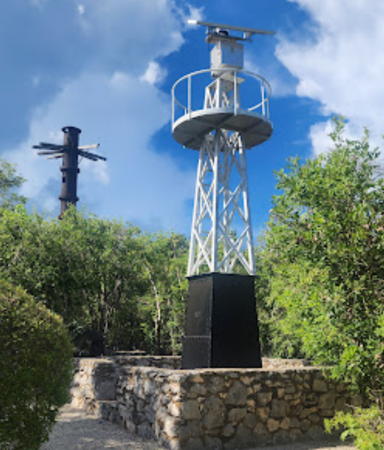
1980. Inactive since 2023. 6 m (20 ft) round concrete tower topped by a skeletal mast. The tower is white with a black band on the mast. Douglas Cameron's photo is above, Trabas has Arndt's photo, Christopher Price has a street view, and the shadow of the light is seen in Bing's satellite view. This light was built as a memorial to local sailors lost at sea. Located on Harbour Drive just south of Fort Street in Georgetown. Site open, tower closed. ARLHS CAY-002; Admiralty J5232; NGA 13716.
* [Gorling Bluff (East End) (3)]
1937 (station established about 1907). Active; focal plane 22 m (72 ft); two 1.2 s white flashes every 20 s. 8 m (26 ft) square steel skeletal tower, painted white, on a small black base. Marc Barrison's photo is at right, Trabas has a photo, Cherine Usherwood has a 2018 closeup photo, Tisha Titus also has a closeup photo, and Google has a satellite view of the site. The original light was a kerosene lantern displayed from a 19 m (60 ft) ship's mast. The second (1937) light was a steel mast with a lantern holding a kerosene lamp; remains of this light stand behind the current beacon. Located on a bluff in East End Lighthouse Park at the eastern end of Grand Cayman Island. Accessible by a stairway from Austin Conolly Drive; the entrance is marked but there's no parking nearby. Site open, tower closed. Site manager: National Trust for the Cayman Islands. ARLHS CAY-001; Admiralty J5226; NGA 13724.

East End Light
East End Light, Grand Cayman, August 2011
Flickr Creative Commons photo by Marc Barrison


Little Cayman Lights
Little Cayman is located about 100 km (60 mi) east northeast of Grand Cayman. It is a small island, about 16 km (10 mi) long but only about 1.2 km (1 mi) wide, and the permanent population is only about 250.
* [Little Cayman West End (2)]
Date unknown. Active; focal plane about 20 m (66 ft); white flash every 5 s. Approx. 20 m (66 ft) skeletal mast. Harry Lalli has a 2019 street view. Trabas has Capt. Peter's photo of the previous light, a 6 m (20 ft) triangular steel skeletal tower. Neither light is seen clearly in Google's satellite view. Located at the western tip of Little Cayman Island. Island accessible by air from Grand Cayman. Site open, tower closed. Admiralty J5236; NGA 13736.
* [Little Cayman East End]
Date unknown. Active; focal plane 11 m (36 ft); two white flashes every 15 s. 6 m (20 ft) post painted white. T. Harrell has a 2017 photo, Trabas has Capt. Peter's photo, Phil Stahlfeld has a street view, and Google has a distant satellite view. Located at the eastern tip of Little Cayman Island. Site open, tower closed. Admiralty J5237; NGA 13740.
 

Cayman Brac Light
Cayman Brac is located about 8 km (5 mi) east of Little Cayman, the two islands being summits of the same underwater ridge. The island is 19 km (12 mi) long, but like Little Cayman it is only about 1.2 km (1 mi) wide. The population is about 2500. The word brac is Gaelic for a bluff, a reference to the steep bluff at the eastern end of the island. The island is accessible by air from Grand Cayman.

* [Cayman Brac West End]
Date unknown. Active; focal plane 12.5 m (41 ft); two white flashes every 15 s. Approx. 11 m (36 ft) mast. Harry Lalli has a 2019 street view, Trabas has Capt. Peter's photo, and Google has a satellite view of the location. Located adjacent to a resort on the southwestern point of the island. Site open, tower closed. Admiralty J5238; NGA 13744.
* [Cayman Brac East End (1 and 2)]
Late 1930s. Reactivated; focal plane 46 m (151 ft); two white flashes every 15 s. 6 m (20 ft) square steel skeletal tower, lower portion enclosed. Upper half of the tower painted red, enclosed section black. This light was replaced in the 1980s by a white triangular skeletal tower with a solar-powered lens. However, a 2011 Google street view and George Kinsley's 2020 photo seen at right show that sometime in 2009-10 the light was returned to the older tower. Greg Paret has a good 2008 photo of both beacons, Joseph Domingo also has a 2008 photo, Trabas has Capt. Peter's photo, Forand has a postcard photo, and Google has a satellite view. Located atop a 43 m (140 ft) vertical cliff at the eastern end of Cayman Brac. The bluff is popular with rock climbers. Site open; nothing prevents visitors from climbing on the towers. Admiralty J5240; NGA 13748.


East End Light, Cayman Brac, January 2020
Google Maps photo by George Kinsley

Information available on lost lighthouses:

Notable faux lighthouses:

Adjoining pages: North: Western Cuba | East: Jamaica

Return to the Lighthouse Directory index | Ratings key

Posted September 19, 2005. Checked and revised December 7, 2023. Lighthouses: 0. Site copyright 2023 Russ Rowlett and the University of North Carolina at Chapel Hill.