Lighthouses of Jamaica

The largest island of the former British West Indies, Jamaica is 234 km (145 mi) long and 80 km (50 mi) wide. After being colonized by Spain in the early 1500s Jamaica was conquered by Britain in 1655. After three centuries as a British colony the island has been an independent nation within the British Commonwealth since 1962. Kingston, on the south coast, is the capital, largest city, and most important port of the country. Jamaica has a population of about 2.8 million and is well known as a tourist destination.

Jamaica has seven historic lighthouses, no one of them like any of the others and all of them interesting in their design. All seven lighthouses are accessible, but several of them are rather poorly known.

Historically Jamaica was divided into three counties, but the counties no longer have any function; for local government they are subdivided into fourteen units called parishes.

Aids to navigation in Jamaica are maintained by the Port Authority of Jamaica, an agency of the Ministry of Transport and Works.

ARLHS numbers are from the ARLHS World List of Lights. Admiralty numbers are from volume J of the Admiralty List of Lights & Fog Signals. U.S. NGA List numbers are from Publication 110.

General Sources
Jamaica National Heritage Trust - Lighthouses
Historical descriptions and small photos posted by the Jamaica National Heritage Trust.
Online List of Lights - Jamaica
Photos by various photographers posted by Alexander Trabas; most of the Jamaican photos are by Capts. Peter Mosselberger or Theo Hinrichs.
Lighthouses in Jamaica
Photos by various photographers available from Wikimedia.
World of Lighthouses - Jamaica
Photos by various photographers available from Lightphotos.net.
Jamaica Lighthouses
Aerial photos posted by Marinas.com.
Leuchttürme Mittelamerikas und der Karabik auf historischen Postkarten
Historic postcard images posted by Klaus Huelse.
GPSNavigationCharts
Navigation chart information for Jamaica.
Navionics Charts
Navigation chart for Jamaica.


Folly Point Light, Port Antonio, September 2021
ex-Google Maps photo by Viacheslav Rakhmanov
Surrey County (Eastern Jamaica) Lighthouses

Portland Parish Lighthouses
Port Antonio West Harbor Range Front (1 and 2)
Date unknown. Active; focal plane 8 m (26 ft); continuous red light. 8 m (26 ft) post standing in front of an 8 m (26 ft) pyramidal skeletal tower that formerly carried the light. The post carries a rectangular white daymark panel. Trabas has Capt. Peter's photo and Bing has an indistinct satellite view. Port Antonio, on the northeast coast of Jamaica, has two harbors separated by a narrow peninsula. Located on a platform just offshore on the west side of the West Harbor. Accessible only by boat. Site open, tower closed. Admiralty J5275; NGA 13844.
Port Antonio West Harbor Range Rear
Date unknown. Active; focal plane 84 m (276 ft); continuous red light. 6 m (20 ft) square pyramidal stone tower painted white. Trabas has Capt. Peter's photo and Google has a satellite view. Located at the end of Springbank Road on the mountainside behind the port. Site status unknown. Admiralty J5275.1; NGA 13848.
* Folly Point (Port Antonio)
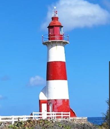
1888. Active; focal plane 16 m (53 ft); white light, 2 s on, 8 s off. 15 m (49 ft) round brick tower with lantern and gallery, painted with red and white horizontal bands; solar-powered lens. Frans Eijgenraam found a beautiful garden surrounding the lighthouse in 2000. Viacheslav Rakhmanov posted the closeup 2021 photo seen at the top of this page, Trabas has Capt. Peter's photo, Stéphane Damour has a 2015 photo, a 2012 photo is available, Marinas.com has aerial photos, Huelse has a historic postcard view, Tony Kenny has a 2017 street view, and Google has a satellite view. Long in need of attention, this lighthouse was restored and repainted in 2018-19. Kamila Drnkova has a February 2019 photo showing the work in progress and Gabriel Steinmüller has a September 2019 photo showing the results. The lighthouse is close to the Folly Ruins, a collapsing mansion built by American millionaires in 1905. Located at the end of the Folly Peninsula on the east side of the East Harbor of Port Antonio. Site open, tower closed. . ARLHS JAM-001; Admiralty J5272; NGA 13832.

Saint Thomas Parish Lighthouse
** Morant Point
1841 (Alexander Gordon, designer; George Grove, contractor). Active; focal plane 35 m (115 ft); three white flashes every 20 s. 29 m (95 ft) round cast iron tower with lantern and gallery, painted with red and white horizontal bands. To protect against surf during hurricanes, a semicircular masonry wall has been built around the seaward side of the base of the lighthouse. A 2021 photo by Matthew deCasseres is at right, Morris Sinclair has a 2019 closeup photo, Trabas has a 2016 photo by Capt. Theo Hinrichs, Michael Dorn has a 2006 photo and a view of the light station, the Port Antonio Guesthouse Association also has a page for the lighthouse, Wikimedia has Dorn's closeup, Marinas.com has aerial photos, and Google has a satellite view. This historic tower is the oldest lighthouse on the island and the first cast iron lighthouse built in the Western Hemisphere. A historical exhibit was planned for installation at the keeper's house. but there's no evidence this was accomplished. A 2011 photo by Charlene Collins showed the lighthouse in serious need of repainting and restoration; the lighthouse was painted around the end of 2015. Located at Morant Point, the easternmost point of Jamaica. Accessible in dry weather by an unpaved road to the point (a "temporary" detour has been used since the main road was washed out by Hurricane Gilbert in 1988). Site open; the tower is open by arrangement with the keeper. . ARLHS JAM-004; Admiralty J5282; NGA 13860.

Morant Point Light, St. Thomas Parish, December 2021
Google Maps photo by Matthew deCasseres

Kingston Parish Lighthouses
* Plumb Point
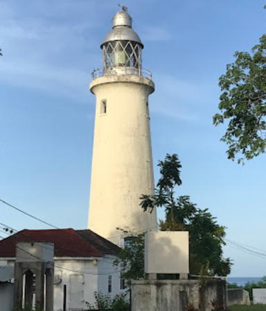
1853. Active; focal plane 21 m (69 ft); flash every 9 s, alternating red and white. 21 m (69 ft) two-stage round tower, lower half stone and upper half cast iron, with lantern and gallery. Entire lighthouse painted white. Viacheslav Rakhmanov has a closeup 2021 photo, Trabas has Capt. Peter's photo (also seen at right), Rochelle Knight has a nice 2018 view, a closeup 2008 photo is available, Ray Edwards has a drone view, Marinas.com has aerial photos, Huelse has a historic postcard view, and Google has a good satellite view. This lighthouse is in the Port Royal Historic District, which the government hopes to develop as a tourist attraction. Famous as a hangout for pirates, Port Royal was destroyed by an earthquake in 1692. Located at Great Plumb Point on the Palisadoes Peninsula, near the Palisadoes Airport, about 8 km (5 mi) east of Port Royal and the entrance to Kingston Harbour. Accessible by paved road. Site open, tower closed but it appears that vistors can climb halfway up the tower on the external stairway. . ARLHS JAM-005; Admiralty J5294; NGA 13908.
Rackhams Cay Range Front
Date unknown. Active; focal plane 16 m (52 ft); white flash every 3 s, synchronized with the rear light. 18 m (59 ft) square skeletal tower mounted on a square concrete platform supported by piles. Trabas has Capt. Peter's photo and Google has a satellite view. The range guides vessels westward on their approach to Kingston Harbour. Located about 1.2 km (3/4 mi) west southwest of the point of Port Royal. Accessible only boat. Site open, tower closed. Admiralty J5295.95; NGA 13928.

Middlesex County South Coast Lighthouses

Saint Catherine Parish Lighthouse
Lazaretto Cairn (Rackhams Cay Range Rear)
Date unknown. Active; focal plane 28 m (92 ft); white flash every 3 s, synchronized with the front light. Approx. 9 m (30 ft) solid triangular pyramidal tower, painted white. Trabas has Capt. Peter's photo, Dennis Thaxter has a 2020 photo, and Google has a satellite view. This appears to be a historic daybeacon converted to a lighted aid. Located on a bluff on the west side of the Kingston Harbour entrance, opposite Port Royal. Site probably open, but local knowledge and 4WD is probably required; tower closed. Admiralty J5296; NGA 13932.

Clarendon Parish Lighthouses
Pigeon Island Range Rear
Date unknown. Active; focal plane 24 m (79 ft); white light, 2 s on , 4 s off, visible only on or near the range line. 23 m (75 ft) square skeletal tower with gallery, painted white. The tower also carries a white triangular daymark, point down. Trabas has Capt. Peter's photo and Google has a satellite view. The range guides vessels into Portland Bight, an embayment on the south coast of Jamaica. The front light is on a post. Located on a reef in the entrance to Portland Bight. Accessible only boat. Site open, tower closed. Admiralty J5327.9; NGA 14080.

Plumb Point Light, Kingston, 2018
photo copyright Capt. Peter Mosselberger
used by permission
Portland Ridge (Portland Point)
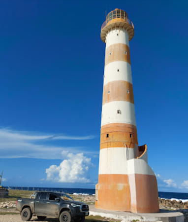
Date unknown. Active; focal plane 198 m (650 ft); two white flashes every 15 s. 35 m (115 ft) square pyramidal cast iron or steel skeletal tower with lantern and gallery. Tower sections painted alternately red and white, lantern and gallery red. Ronali Allen has a closeup photo, Trabas has Capt. Peter's distant view, and Google has a satellite view. This is Jamaica's tallest light tower. Nakeshia Wellington-Wright has a 2021 photo that shows scaffolding around the top of the tower. The light station and surrounding land are leased to the PWD Hunting and Sporting Club. Located on the Portland Ridge near the southernmost point of the island. Accessible by a hike of about 8 km (5 mi) (access road gated for cars). Site status unknown. ARLHS JAM-006; Admiralty J5327; NGA 14112.

Cornwall County (Western Jamaica) Lighthouses

Saint Elizabeth Parish Lighthouse
*** Lover's Leap
Date unknown (1960s?). Active; focal plane 530 m (1739 ft); white flash every 10 s. 30.5 m (100 ft) round cylindrical steel (?) tower with lantern and octagonal gallery. Tower painted with red and white horizontal bands; lantern white, gallery red. Paul Jonusaitis's photo is at right, Charles Bash has a 2007 closeup, Lightphotos.net has a good photo, Trabas has Capt. Theo's closeup photo, Ricardo Henry has a 2018 photo, a 2022 photo is available, Marinas.com has aerial photos, and Google has a good satellite view. This is the highest lighthouse in the Western Hemisphere; in good weather its light can be seen for 40 nautical miles (74 km or 46 mi). JNHT says this is also the newest Jamaican lighthouse, evidently built after Jamaica became independent (1962). The area has been developed as a tourist attraction with a restaurant and observation deck near the lighthouse. Located in Southfield, 32 km (20 mi) south of Mandeville at the top of a spectacular cliff. Site open; tower open daily except Sundays year-round. . ARLHS JAM-003; Admiralty J5341; NGA 14124.

Lovers Leap Light
Lovers Leap Light, Southfield, February 2007
Flickr Creative Commons photo by Paul Jonusaitis


Westmoreland Parish Lighthouse
*** South Negril Point
1894. Active; focal plane 31 m (101 ft;) flash every 2 s, alternating red and white. 27 m (89 ft) round reinforced concrete tower with lantern and gallery; solar-powered lens. Tower and gallery painted white; lantern unpainted gray metal. Several 1-story frame keeper's houses are staffed. Bernd Zehring's photo is at right, J.C. Rowland has a 2021 closeup, Larry Moe has a closeup photo, Trabas has Capt. Peter's photo, Donald Allen has a 2018 photo, Charles Bash has a photo, Nicodemus Jordan has a nice photo of the station, Marinas.com has aerial photos, and Google has a good satellite view. Built by a French company, this is one of the earliest concrete lighthouses. A well-known attraction of the Negril area. Located at South Negril Point, near the westernmost point of the island. Parking provided. Site open, tower open by appointment. . ARLHS JAM-007; Admiralty J5244; NGA 14144.

Saint James Parish Lighthouse
* Rose Hall (Cinnamon Hill)
Date unknown. Active; focal plane 32 m (105 ft); five white flashes every 30 s. Approx. 27 m (92 ft) square steel skeletal tower with gallery, painted white. Jason Henry has a closeup photo, Trabas has Capt. Peter's photo and Google has a satellite view. This light marks the northernmost bend of Jamaica's coastline. Located on the Cinnamon Hill golf course at Rose Hall, about 25 km (15 mi) east of Montego Bay. Site open, tower closed. Site manager: Hilton Rose Hall Resort. Admiralty J5253; NGA 13776.

Middlesex County North Coast Lighthouse

Saint Mary Parish Lighthouse
* Galina Point (2)
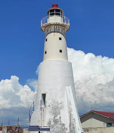
Date unknown (station established 1912). Active; focal plane 19 m (62 ft); white flash every 12 s. 13 m (42 ft) strongly-tapered triangular white concrete tower, with no lantern; a solar-powered lens is mounted on a small platform at the top. Thaelia McZenna has a 2020 photo, a 2012 photo is available, Trabas has Capt. Peter's photo, Errol Rhoden has a drone view, Marinas.com has aerial photos, and Google has a satellite view. Located at Galina, off highway A3 about 7 km (4.5 mi) north of Port Maria and a similar distance east of Oracabessa on the northern coast of Jamaica. Site open, tower closed. . ARLHS JAM-002; Admiralty J5266; NGA 13828.


Negril Point Light, Negril, February 2012
Google Maps photo by Bernd Zehring

Morant Cays Lighthouse

The Morant Cays are a group of small islands on a coral reef 51 km (32 mi) south southeast of Morant Point. The islands were claimed by Great Britain in 1862 and annexed to Jamaica in 1882. There is no permanent population but a fishing camp is often occupied.

Morant Cays (2?)
Date unknown (1960s?). Active; focal plane 23 m (75 ft); white light, 4 s on, 6 s off. 21 m (69 ft) round metal (?) tower, painted with black and white horizontal bands. Trabas has a photo by Capt. Peter, William Pozo has a distant drone view, and Bing has a satellite view of the island. The light lists describe this light as a framework tower, so the present tower might not be the original lighthouse. Located on Northeast Cay, at the easternmost point of the islands. Accessible only by boat. Site open, tower closed. Admiralty J5356; NGA 13864.

Information available on lost lighthouses:

Notable faux lighthouses:

Adjoining pages: North: Eastern Cuba | East: Navassa Island | West: Cayman Islands

Return to the Lighthouse Directory index | Ratings key

Posted 2001. Checked and revised December 7, 2023. Lighthouses: 14. Site copyright 2023 Russ Rowlett and the University of North Carolina at Chapel Hill.