Lighthouses of Western Cuba

The Republic of Cuba includes the largest island of the West Indies, also called Cuba, located at the northwest corner of the Caribbean Sea across the Florida Strait from the United States. Cuba was a Spanish colony until it was conquered by U.S. forces during the Spanish-American War of 1898. The U.S. occupation ended officially in 1902. Nineteenth century Cuban lighthouses therefore have Spanish designs. At least two surviving lighthouses, Cayo Jutías and Punta de los Colorados, were built under the U.S. occupation.

Cuba is divided into 15 provinces and one special municipality (Isla de la Juventud). This page includes lighthouses of the western half of the island, from Villa Clara and Cienfuegos Provinces westward. There's another page for Eastern Cuba.

Due to longstanding political difficulties between Cuba and the U.S. American tourists had practically no access to these lighthouses for more than 50 years. This is changing now that the two countries have resumed contacts, but it is still true that most of the information available on the Internet has been posted by European or Canadian visitors or by Cuban tourist agencies.

Aids to navigation in Cuba are regulated by the Oficina Nacional Hidrografia y Geodesia and maintained by the Ayuda a la Navegación division of Grupo Empresarial Geocuba. Many Cuban lighthouses are not automated and keepers are on site at most locations. Some of the stations are staffed by civilian keepers but some are tightly restricted military posts. In general the information on the Internet indicates that the major lighthouses, at least, are well maintained. More information is needed on these lighthouses. If you have information or photos you are willing to share, please contact me.

In Spanish the word for a lighthouse is faro, baliza is a beacon, isla is an island, cabo is a cape, punta is a promontory or point of land, péñon is a rock, arrecife is a reef, bahía is a bay, ría is an estuary or inlet, estrecho is a strait, río is a river, and puerto is a port or harbor.

ARLHS numbers are from the ARLHS World List of Lights. CU numbers are from the Cuban light list; it is not available online but many numbers appear in the Admiralty's Notice to Mariners of 2012 Week 45. Admiralty numbers are from Volume J of the Admiralty List of Lights & Fog Signals. U.S. NGA numbers are from Publication 110.

General sources
Online List of Lights - Cuba
Photos by various photographers posted by Alexander Trabas.
Lighthouses in Cuba
Photos by various photographers available from Wikimedia.
Leuchttürme in Kuba
Photos posted by Andreas Köhler.
World of Lighthouses - Cuba
Photos by various photographers available from Lightphotos.net.
Phares d'Amérique
Photos posted by Alain Guyomard and Robert Carceller on their Phares du Monde web site.
Leuchttürme Mittelamerikas und der Karibik auf historischen Postkarten
Historic postcard views posted by Klaus Huelse.
Bahamas and West Indies
Historic postcard views posted by Michel Forand.
U.S. NOAA Chart 11013
Navigational chart for Florida Straits, Cuba, and Bahamas.
GPSNauticalCharts
Navigational chart information for Cuba.
Navionics Charts
Navigational chart information for Cuba.
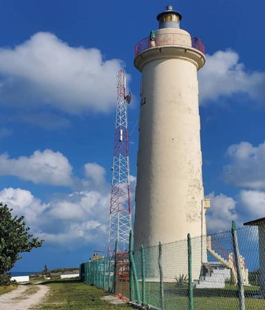
Faro de Roncali
Faro de Roncali (Cabo San Antonio Light), 2005
photo copyright Garry Searle; used by permission
Cienfuegos Province Lighthouses
Cienfuegos is a major seaport on the central south coast of Cuba. The city has a population of about 170,000. It faces an almost-landlocked bay, the Bahía de Cienfuegos, connected to the sea by a narrow strait, the Estrecho de Jagua.
*** Río Yaguanabo (Jaguanabo)
Date unknown. Active; focal plane 58 m (190 ft); white flash every 10 s. 34 m (112 ft) round cylindrical concrete tower with gallery and six buttresses, attached to a 1-story keeper's house. Lighthouse painted white. Köhler has a photo, Agustin Mantilla has a closeup photo, Trabas has Peter Doll's photo, and Google has a satellite view. The keepers maintain a small maritime museum and conduct tours of the tower. This lighthouse is just off the south coast highway (CU 12) at the entrance to the Río Yaguanabo, about 40 km (25 mi) southeast of Cienfuegos. Site and tower open. ARLHS CUB-035; CU-0894; Admiralty J5093; NGA 13464.
* Punta de los Colorados (Cienfuegos, Faro de Villanueva) (2)
1901 (E.J. Balbín) (station established 1851). Active; focal plane 25 m (82 ft); white flash every 5 s. 20 m (66 ft) round masonry tower with lantern and gallery, painted white. Two 1-story keeper's houses and other buildings enclosed by a stone wall. A photo is at right, Trabas has Douglas Cameron's photo, Köhler has a good photo, Rafael Estrada has a photo, Gustavo Rumbaut Martinez has a closeup, Huelse has a historic postcard view, and Google has a satellite view. The first lighthouse was destroyed by U.S. naval bombardment during the Spanish-American War and a temporary light was shown from a mast until the present lighthouse was completed. Located at the eastern entrance to the Estrecho de Jagua. Site open, tower status unknown. ARLHS CUB-028; CU-0895; Admiralty J5094; NGA 13468.
Punta de Pasacaballos (Pasa Caballos)
Date unknown. Active; focal plane 10 m (33 ft); red flash every 4 s. 8 m (26 ft) square skeletal tower mounted on a small equipment shelter. Lighthouse painted red. Trabas has Douglas Cameron's photo, another photo is available, and Google has a satellite view. Located on a sharp point of land on the east side of the Estrecho de Jagua opposite the Castillo de Jagua. Site status unknown. CU-0908; Admiralty J5096; NGA 13492.

Matanzas Province South Coast Lighthouses
* Playa Girón
Date unknown. Inactive at least since 2018. The light was on an 18 m (59 ft) water tank topped by a small pedestal. The tank is at the far left of Enrique Guzman's view of the waterfront and Google has a satellite view. Playa Girón is a beach resort on the edge of the Ciénaga de Zapata (Zapata Swamp) at the south end of Matanzas Province. The area was the site of the Bay of Pigs invasion in 1961, when U.S.-backed Cuban exiles tried unsuccessfully to overthrow the government of Fidel Castro. Located on the beach near the west end of Playa Girón. Site open, tower closed. ex-CU-0969; ex-Admiralty J5103; ex-NGA 13538.

Punta de los Colorados Light, Cienfuegos, October 2018
Google Maps photo by cafes 915
Cayo Piedras del Sur (3?)
2018 (station established 1863). Active; focal plane 15 m (49 ft); white flash every 10 s. 14 m (46 ft) square skeletal tower. No photo available but Bing has a satellite view. The light marks the west side of the entrance to the Bahía de Cochinos (the Bay of Pigs). The original light was described as a "mast on house." It was demolished in the early 1960s when Fidel Castro had the cay developed as his vacation retreat. The Admiralty's 2012 listing is of a 10 m (33 ft) fiberglass tower. Located on a small, inhabited island about 15 m (9 mi) southwest of Playa Girón. Accessible only by boat. Site status unknown. ARLHS CUB-024; CU-0982; Admiralty J5104; NGA 13524.

Mayabeque Province South Coast Lighthouses
Cayo Monterrey
Date unknown. Active; focal plane 11 m (36 ft); white flash every 10 s. 13 m (43 ft) square skeletal tower with gallery, painted white and mounted on a square platform supported by piles. No photo available but Bing has a satellite view. Located at the southwest end of a reef that extends 10 km (6 mi) from Cayo Monterrey at the entrance to the shallow Golfo de Batabanó. Accessible only by boat. Site status unknown. CU-1160; Admiralty J5160; NGA 13656.
* Batabanó (Surgidero de Batabanó) (5)
Date unknown (station established 1847). Active; focal plane 31 m (102 ft); white flash every 10 s. 28 m (92 ft) water tank topped by a small lantern structure. Water tank painted white. The tank is at the far left of a distant view and Google has a satellite view. The anchorage (surgidero) of Batabanó is connected to Havana by a railway and serves as a minor port for the capital on the south side of the island. A series of mast-type lists was succeeded by a skeletal tower in 1930 and then by the present light atop the tallest structure in the port. Site open, tower closed. ARLHS CUB-042; CU-1165; Admiralty J5166; NGA 13647.

Isla de la Juventud (Isle of Pines) Lighthouses
The Isla de la Juventud (Isle of Youth, formerly the Isla de Pinos or Isle of Pines) is a large island about 100 km (60 mi) south of Pinar del Río province. The island is roughly 50 km (30 mi) in diameter and has a population of about 85,000. It is accessible by air or by fast ferries from Surgidero de Batabanó. Governed as a provincial-level special municipality, Isla de la Juventud includes the Los Canarreos Archipelago, a chain of smaller islands and reefs extending eastward about 150 km (95 mi) separating the shallow Gulf of Batabanó from the open Caribbean Sea.

Cayo Guano del Este (2)
1970 (station established 1909). Active; focal plane 54 m (177 ft); two white flashes every 15 s. 45 m (148 ft) slender round cylindrical tower with lantern and gallery supported by five struts atop a round 1-story keeper's quarters. This unusual lighthouse looks somewhat like a rocket taking off. Gerhard Vogt's photo is at right, Dmitry Subbotin has a 2022 view from the sea, another photo (2/3 the way down the page) is available, and Bing has a satellite view. The original lighthouse was a sibling of the Cayo Jutías lighthouse (see below). The cay is a popular scuba diving site. Located at the eastern end of the Banco Jardines reef complex, at the east end of the Los Canarreos chain, about 100 km (60 mi) southwest of Cienfuegos. Accessible only by boat. Site open, tower open by arrangement with the keepers. . ARLHS CUB-001; CU-1006; Admiralty J5102; NGA 13536.
Cayo Largo Northwest
Date unknown. Active; focal plane 13 m (43 ft); white flash every 6 s. 7 m (23 ft) white post on a square base. A closeup photo is available and Bing has a satellite view. The resort island of Cayo Largo del Sur, about 25 km (15 mi) long but only 3 km (2 mi) wide, is the largest of the islands in the Los Canarreos chain. Located on a small island, Isla Iguana, off the northwest end of Cayo Largo. Accessible only by boat. Site open, tower closed. ARLHS CUB-008; CU-1007; Admiralty J5130; NGA 13572.

Cayo Guano del Este Light, Canarreos, November 2017
Instagram photo by Gerhard Vogt
Carapachibey (2)
1983 (station established 1949). Active; focal plane 56 m (184 ft); white flash every 7.5 s. 52 m (171 ft) round cylindrical white concrete tower. A Fresnel lens is in use. A photo is at right, Rodolfo Yondreis Quintana Puche has a closeup and a view from the sea, CubaPLUS magazine has a closeup photo, and Google has a fine satellite view. Locally the lighthouse is claimed to be 60 m (197 ft) tall and the "highest in Latin America," but actually there are several taller lighthouses in Argentina and Brazil. This light replaced lights built on Cabo Pepe, about 15 km (9 mi) to the west. The first Cabo Pepe light, built in 1931, was swept away two years later by a hurricane; its replacement was similarly destroyed in 1944. A Google satellite image shows the site of these lighthouses. The Cabo Pepe station was replaced in 1949 by a 27 m (89 ft) concrete tower at the present location. Located on the southeastern coast of the island. Site status unknown. ARLHS CUB-019; CU-1033; Admiralty J5138; NGA 13580.
Pasa la Manteca (2)
Date unknown. Active; focal plane 12 m (39 ft); white flash every 8 s. 12 m (39 ft) square white skeletal tower on a platform supported by piles. No photo available but Google has a fuzzy satellite view. The light marks a narrow break in the Manteca reef north of the Isla de la Juventud; this pass is used by fast ferries and other vessels bound for the island from the Gulf of Batabanó. The Admiralty listed a fiberglass tower in 2012. Accessible only by boat. Site open, tower closed. CU-1056.1; Admiralty J5193.5; NGA 13630.

Pinar del Río Province (Westernmost Cuba) Lighthouses
La Caloma
Date unknown. Active; focal plane 30 m (98 ft); white flash every 15 s. Approx. 27 m (89 ft) round white water tank. A photo is available and Google has a satellite view. La Caloma is an important fishing port about 20 km (13 mi) southeast of Pinar del Río city. Located on the main quay, on the west side of the harbor. Site and tower closed. CU-1174.5; Admiralty J5202; NGA 13678.

Carapachibey Light, Isla de al Juventud
Creative Commons photo from isladelajuventud-cuba.com
Cabo Francés
Date unknown. Active; focal plane 9 m (30 ft); white flash every 10 s. 8 m (26 ft) white skeletal tower. No photo available but Google has a distant satellite view. Located at the tip of a prominent cape about 5 km (3 mi) south of Babiney. Site open, tower closed. CU-1189; Admiralty J5210; NGA 13708.
Cabo Corrientes
Date unknown (station established 1930). Active; focal plane 27 m (89 ft); white flash every 5 s. 22 m (72 ft) square skeletal tower, painted white. No photo available but Google has a satellite view. Located about 400 m (1/4 mi) north of the point of the cape, a southwestward prong of Pinar del Río about 50 km (30 mi) southeast of Cabo San Antonio and 10 km (6 mi) south of Maria la Gorda. The surrounding area is a nature reserve. Site status unknown. CU-1190; Admiralty J4819 (ex-J5212); NGA 13712.
Cabo San Antonio (Faro de Roncali)
1850 (José Pérez Malo). Active; focal plane 31 m (102 ft); two white flashes every 10 s. 23 m (75 ft) round masonry tower with lantern and gallery. Entire lighthouse painted white. Original 1-story keeper's house. Searle's photo is at the top of this page, Leonardo Maldonado has a 2020 photo, Fabio Bretto has a closeup, Riccardo Ravaglia has a photo, Trabas has Eckhard Meyer's closeup photo, and Google has a satellite view. An important, historic, and well preserved light station. The lighthouse is named for Count Federico Roncali (1809-1857), the Spanish governor of Cuba during its construction. In 2005 Searle found the lighthouse to be staffed by the military and was not able to tour the tower. The lighthouse is accessible by 4WD via a dirt road running the 80 km (50 mi) length of the narrow Guanahacabibes peninsula. Located at the extreme western tip of the island, overlooking the Yucatán Strait. Site open, tower reported closed. ARLHS CUB-017; CU-0001; Admiralty J4820; NGA 12436.
Cayo Buenavista
1930. Active; focal plane 33 m (108 ft); white flash every 5 s. 30 m (98 ft) square pyramidal skeletal tower, painted white. No photo available but Google has a satellite view. Located at the east end of Cayo Buenavista, an island off Mantua. Accessible only by boat. Site status unknown. ARLHS CUB-003; CU-0005; Admiralty J4826; NGA 12460.
Cayo Jutías (1)
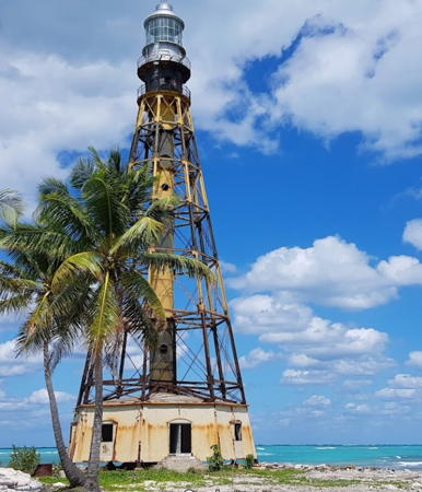
1902 (U.S.). Probably inactive. 41 m (134 ft) octagonal skeletal tower with central cylinder, lantern, and double gallery, built on a screwpile foundation; original Barbier et Bérnard Fresnel lens. Lighthouse painted with black and yellow horizontal bands; lantern unpainted. Augusto Fonseca's 2020 photo is at right, Alejandro Roque has a 2022 photo of the two Cayo Jutías lighthouses, another closeup and a 2023 photo are available, Trabas has Peter Doll's photo, and Google has a satellite view. This lighthouse is the only survivor of four towers of this class built in Cuba during the U.S. occupation of 1898-1903; it was prefabricated in the U.S. by the Waddell & Hedrick Co. of Kansas City. Built at sea level, it is probably endangered by beach erosion and lack of maintenance. The light station was recognized as a national monument in 2002. The cay is located northwest of the Bahía de Santa Lucia in Pinar del Río. Accessible by bridge from the nearby port of Santa Lucia. Site open, tower closed. . ARLHS CUB-022.
Cayo Jutías (2)
2019 (station established 1902). Active (?); focal plane 43 m (141 ft); white light, 2 s on, 13 s off. Approx. 45 m (148 ft) square skeletal tower on a square concrete platform supported by piles. Lighthouse painted with black and yellow horizontal bands. Alejandro Roque has a May 2022 photo of the old and new lighthouses. Located behind the historic lighthouse. Site open, tower closed. CU-0018; Admiralty J4828; NGA 12484.


Cayo Jutías Light, Pinar del Río, February 2020
Google Maps photo
by Augusto Fonseca

Punta Gobernadora (Bahía Honda) (2)
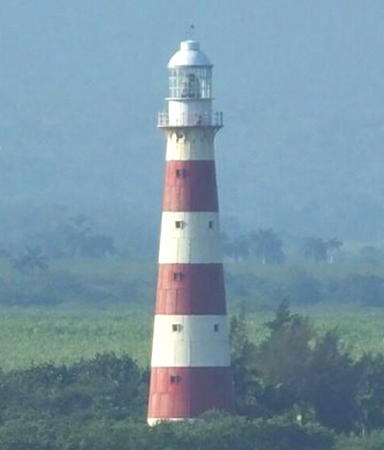
1956 (station established 1902). Active; focal plane 33 m (108 ft); white flash every 5 s. 32 m (105 ft) round tower with lantern and double gallery, painted with red and white horizontal bands. Trabas has Capt. Peter Mosselberger's photo (also seen at right), Pablo Antolin has a 2009 photo, a 2023 photo is available, and Google has a satellite view. The original lighthouse, a sibling of the Cayo Jutías light, was prefabricated by the Waddell & Hedrick Co. in the U.S. Punta Gobernadora is about 3 km (2 mi) northwest of the entrance to Bahía Honda in northwestern Pinar del Río. Site status unknown. ARLHS CUB-029; CU-0032; Admiralty J4836; NGA 12512.
Punta del Morillo (Cerro del Morillo)
Date unknown. Active; focal plane 27 m (89 ft); two white flashes every 10 s. 8 m (26 ft) square pyramidal skeletal tower with lantern, painted white. Capt. Peter Mosselberger has a very distant view from the sea and Google has a distant satellite view. Located on a steep headland on the east side of the entrance to Bahía Honda. Site status unknown. CU-0033; Admiralty J4838; NGA 12516.

Artemisa Province North Coast Lighthouses
In 2011 the former La Habana Province was divided; the portion west of the capital city became Artemisa Province and portion east of the city became Mayabeque Province.

Cerro Frias (Cabañas) (2)
Date unknown (station established 1902). Active; focal plane 53 m (174 ft); white flash every 8 s. 8 m (26 ft) skeletal tower apparently mounted on a 1-story equipment shelter. No photo available but Bing has a satellite view. The original light was described as a mast. Located atop a headland on the west side of the entrance to the Bahía de Cabañas, about 70 km (43 mi) west of Havana. Site status unknown. CU-0056; Admiralty J4842; NGA 12528.
Península Juan Tomas Range Rear
Date unknown. Active; focal plane 15 m (49 ft); white light. 0.75 s on, 0.75 s off. 13 m (43 ft) square white skeletal tower. No photo available but Bing has a satellite view. This is the entrance range for the Bahía de Cabañas. The front light is on a similar tower 10 m (33 ft) tall. Located on a narrow peninsula on the south side of the bay. Site status unknown. CU-0056.11; Admiralty J4841; NGA 12542.5.

Punta Gobernadora Light, Bahía Honda, March 2016
photo copyright Capt. Peter Mosselberger; used by permission
Puerto del Mariel
Date unknown. Active; focal plane 41 m (134 ft); white flash every 12 s. 31 m (102 ft) square skeletal tower. Michal Bielinowicz has a distant view from the sea and a Google's dark satellite view sis centered on the tall tower. The first Mariel lighthouse (1902) was established on the east side of the harbor entrance. The present lighthouse marks the west side of the entrance, about 40 km (25 mi) west of Havana. Mariel is a city of about 45,000 residents located 40 km (25 mi) west of Havana. It is the port closest to the United States and was often a departure point for refugees fleeing the Castro regime. Site status unknown. ARLHS CUB-036; CU-0072; Admiralty J4846; NGA 12552.
* Río Santa Ana
Date unknown. Active; focal plane 56 m (184 ft); white flash every 10 s. Approx. 50 m (164 ft) observation room mounted atop a water tank elevated on a cylindrical column. Tank and lantern painted light blue, column white. A photo by Macson Gonzalez is at right, Andres Alvaro Rodriguez has a photo, Jaak Geens has a 2017 photo and Bing has a satellite view. Located on the campus of the Latin American School of Medicine about 15 km (9 mi) west of Havana Site open, tower apparently open but we have no information on this. Site manager: Escuela Latinoamericana de Medicina. CU-0095; Admiralty J4847.6; NGA 12562.

La Habana (Havana) Province Lighthouses
Founded by Spain in 1519, Havana (La Habana in Spanish) is the capital and largest city of Cuba with a population of about 2.3 million. The city has a large harbor entered through a narrow strait guarded by the historic Castillo del Morro.

*
Darsena de Barlovento (Marina Hemingway)
Date unknown. Active; focal plane 36 m (118 ft); white flash every 7 s. 8 m (26 ft) square skeletal tower mounted atop a multi-story hotel. Tower painted white. Lightphotos.net has a closeup photo, Trabas has Köhler's view from ground level and Bing has a satellite view. Marina Hemingway is a large resort development and marina located about 15 km (9 mi) west of downtown Havana. Site open, tower closed. Site manager: Marina Hemingway. CU-0112; Admiralty J4848; NGA 12564.
 

Río Santa Ana Light, Havana, November 2017
Google Maps photo by Macson Gonzalez
 
**** Castillo del Morro (3)
1845 (station established 1764). Active; focal plane 44 m (144 ft); two white flashes every 15 s. 25 m (82 ft) unpainted round masonry tower with lantern and gallery, built on the ramparts of the Castillo de los Tres Reyes del Morro (El Morro Castle). Lighthouse floodlit at night. This familiar landmark of Havana harbor is a symbol of the city and by far Cuba's best known lighthouse. A photo is at right, Trabas has a closeup photo by Carlos María Silvano, Köhler has a photo, another fine closeup is available, Guyomard and Carceller have photos by Chantal Penet, Huelse has a historic postcard view, Forand has a closeup postcard view, Iván Calás has a street view, and the tower is seen in Google's satellite view. The original lighthouse was replaced in 1818 by a round cylindrical masonry tower. The lighthouse is built inside the historic Castillo del Morro (Morro Castle, officially the Castillo de los Tres Reyes Magos del Morro), which has protected the entrance to Havana harbor since 1589. Located on the east side of the very narrow entrance to Havana harbor. Site and tower open daily. Site manager: Parque Histórico Militar El Morro-La Habaña. . ARLHS CUB-009; CU-0131; Admiralty J4857; NGA 12580.
* Neptuno (2?)
Date unknown. Active; focal plane about 12 m (39 ft); red flash every 4 s. Approx. 11 m (36 ft) square red skeletal tower. Trabas has Douglas Cameron's photo, Daniel Chruszcz has an evening street view, Lightphotos.net had Sergey Dolya's drone view, and Google has an indistinct satellite view. Light lists have the focal plane as 8 m (26 ft), clearly too low. Located on the Malecón opposite the Castillo de la Real Fuerza de La Habana (Castle of the Royal Force), marking the west side of the exit from the inner harbor. Site open, tower closed. CU-0135.1; Admiralty J4858; NGA 12585.
Havana Inner Harbor Range No. 1 Rear
Date unknown. Active; focal plane 18 m (59 ft); quick-flashing yellow light. 32 m (105 ft) square pyramidal skeletal tower; the light must have been lowered to the middle section of the tower. No photo available but Bing has a satellite view. The front light is on a slender 12 m (39 ft) skeletal tower. Located in an industrial area at the southeastern end of Havana harbor. Site and tower closed. CU-0138; Admiralty J4860.1; NGA 12592.
Havana Inner Harbor Range No. 2 Rear
Date unknown. Active; focal plane 19 m (62 ft); yellow light, 3 s on, 3 s off. 18 m (59 ft) square pyramidal skeletal tower, painted white and with a slatted daymark painted black with a long yellow arrow pointed up. Trabas has Douglas Cameron's photo and Bing has a satellite view. The front light is on a slender 12 m (39 ft) skeletal tower carrying a slatted daymark painted white with a large red diamond. Located in an industrial area at the southeastern end of Havana harbor. Site and tower closed. CU-0133; Admiralty J4859.1; NGA 12598.

Castillo del Morro Light, Havana, January 2014
Wikimedia Creative Commons photo
by Mariordo

Mayabeque Province North Coast Lighthouses
Río Jaruco
Date unknown. Active; focal plane 17 m (56 ft); white flash every 10 s. 10 m (33 ft) square fiberglass tower, colored with red and white horizontal bands. Wilfried Kalinowski's photo is at right and Google has a satellite view. Located on the west side of the entrance to the Río Jaruco, about 10 km (6 mi) west of Santa Cruz del Norte. Site status unknown. CU-0148; Admiralty J4867; NGA 12612.
Canasí (Arcos de Canasí)
Date unknown. Active; focal plane 125 m (410 ft); white flash every 7 s. 14 m (46 ft) fiberglass tower, colored white with a red horizontal band. No photo available but Bing has a satellite view. Cuba's highest light stands on a high bluff above the beach north of Arcos de Canasí in the northeast corner of Mayabeque province. Site status unknown. ARLHS CUB-018; CU-0150; Admiralty J4867.5; NGA 12613.

Matanzas Province North Coast Lighthouses
Punta Seboruco (2)
Date unknown (station established 1930). Active; focal plane 35 m (115 ft); white flash every 15 s. 33 m (108 ft) slender round concrete tower with lantern and gallery, painted with red and white bands. Lightphotos.net has Köhler's photo, Trabas also has Köhler's photo, and Google has a satellite view showing the lighthouse standing very close to the beach. The original lighthouse was a 20 m (66 ft) skeletal tower. Located about 8 km (5 mi) north of Matanzas. Site status unknown. ARLHS CUB-034; CU-0151; Admiralty J4868; NGA 12616.

Río Jaruco Light, Santa Cruz del Norte, November 2017
photo copyright Wilfried Kalinowski; used by permission
Punta Maya (2)
1988 (station established 1898). Active; focal plane 34 m (112 ft); white flash every 8 s. 32 m (105 ft) hexagonal cylindrical concrete tower with lantern and gallery. Lighthouse painted white. This light station is staffed by the military. Armel Josso has a closeup photo, Trabas has Köhler's closeup, Köhler also has a photo of the station, a 2022 photo and a distant view are available, Armel Josso has a photo, and a Google satellite view shows the light station on the beach. A seawall has been built to protect it. A postage stamp has an image of the original Spanish lighthouse. The new lighthouse commemorates the 30th anniversary of the revolution that brought Fidel Castro to power. Located on Punta Maya at the east side of the entrance to the Bahía Matanzas. Site and tower closed: Searle was allowed to take a photo from outside the gate of the military area. ARLHS CUB-032; CU-0152; Admiralty J4872; NGA 12620.
Cayo Piedras del Norte (2)
1857 (station established 1847). Active; focal plane 24 m (79 ft); white flash every 10 s. 19 m (62 ft) round masonry tower with lantern and double gallery, painted white, attached to two 1-story keeper's houses. Trabas has Capt. Peter Mosselberger's view from the sea, Guyomard and Carceller have several photos by Chantal Penet and Google has a good satellite view. In May 2004 Tom Pohrt found the lighthouse staffed by the military; the tower was in good condition but the roof had collapsed on one of the keeper's houses (this can be seen in the satellite view). The original lighthouse, a 25 m (82 ft) wood tower, was destroyed by a hurricane in August 1856. Located on a small cay about 8 km (5 mi) northwest of the entrance to the Bahía de Cárdenas. Site and tower closed. ARLHS CUB-013; CU-0182; Admiralty J4879; NGA 12648.
Cayo Diana (7?)
Date unknown (station established 1847). Active; focal plane 15 m (49 ft); white flash every 8 s. 12 m (39 ft) skeletal tower, painted white. 1-story masonry keeper's house. No photo available but Bing has a satellite view. The first light, on a mast, was destroyed by an 1856 hurricane, and the second was lost during the Spanish-American War. The present light replaced a 9.5 m (31 ft) skeletal tower built in 1931 along with the keeper's house. Located on a small cay in the center of the entrance to the Bahía de Cárdenas. Accessible only by boat. Site status unknown. CU-0178; Admiralty J4881; NGA 12660.
Cayo Cruz del Padre (Faro Hernan Cortés) (2)
1862 (Armando de Velasco). Active; focal plane 25 m (82 ft); white flash every 7 s. 25 m (82 ft) square cylindrical concrete skeletal tower surrounding and rising above a 15 m (49 ft) round cylindrical stone light tower, all attached to a 1-story stone Spanish keeper's house. A concrete seawall surrounds the station. A photo appears at right, Trabas has Capt. Peter Mosselberger's fuzzy photo, and Google has a satellite view. Huelse has a historic postcard view (misidentified on the card as Cayo Piedra) that shows the original appearance of the lighthouse. The skeletal extension was added in 1982. The light marks the northernmost point of Cuba and warns mariners from the numerous cays off the north coast of Matanzas. Located in the shallows off the northern tip of Cayo Cruz del Padre. Accessible only by boat. Site and tower closed. ARLHS CUB-037; CU-0245; Admiralty J4886; NGA 12672.
Cayo Cruz del Padre Light
Cayo Cruz del Padre Light, Matanzas, 2012
Google Maps photo by CEOSGOL (César O. Gómez López)

Villa Clara Province Lighthouses
Cayo Bahía de Cádiz
1862 (Armando de Velasco). Active; focal plane 54 m (177 ft); three white flashes every 15 s. 49 m (161 ft) cast iron tower with lantern and double gallery, painted in a black and white checkered-stripe pattern (similar to the second Cape Henry, Virginia, lighthouse). 1-story keeper's houses. A photo by César O. Gómez López is at right, ARLHS has the same photo, a blogger has posted black and white photos, and Google has a satellite view. Cuba's second tallest lighthouse, this light appears to be a sibling of the Faro Paredón (see the Eastern Cuba page). The cast iron was imported from England. A historic photo shows that the tower was formerly painted all white. When David Allester and Eileen Quinn visited here in May 2004 the military commander gave them a tour of the lighthouse. Located in the Archipiélago de Sabana off northwestern Villa Clara. Accessible only by boat. Site status unknown. ARLHS CUB-015; CU-0246; Admiralty J4888; NGA 12676.
Cayo del Cristo
Date unknown. Active; focal plane 15 m (49 ft); white flash every 10 s. 12 m (39 ft) square skeletal tower atop a square base. No photo available but Google has a satellite view. Located on a cay about 10 km (6 mi) north of Isabela de Sagua. Site status unknown. CU-0249; Admiralty J4896; NGA 12688.
Cayo Fragoso
Date unknown (station established 1930). Active; focal plane 21 m (69 ft); white flash every 15 s. 18 m (59 ft) square pyramidal skeletal tower, painted white. No photo available but Bing has a satellite view. It's not known whether the present light is the original. Cayo Fragoso is the largest barrier island of the Sabana-Camaguëy Archipelago north of Caibarién. Located at the northwestern end of the cay. Accessible only by boat. Site status unknown. CU-0284; Admiralty J4900; NGA 12716.

Cayo Bahía de Cádiz Light, Villa Clara, January 2017
Google Maps photo by CEOSGOL (César O. Gómez López)
Cayo Francés (2)
Date unknown (station established 1883). Active; focal plane 10 m (33 ft); white flash every 10 s. 9 m (30 ft) round white concrete tower. No photo available but Google has a satellite view. The original lighthouse was described as a "white building with crane." Located on a small cay at the entrance to the port of Caibarién. Accessible only by boat. Site status unknown. ARLHS CUB-021; CU-0285; Admiralty J4902; NGA 12736.

Information available on lost lighthouses:

Notable faux lighthouses:

Adjoining pages: North: Florida Keys | East: Eastern Cuba | South: Cayman Islands

Return to the Lighthouse Directory index | Ratings key

Posted 2003. Checked and revised November 22, 2023. Lighthouses: 40. Site copyright 2023. Russ Rowlett and the University of North Carolina at Chapel Hill.