Lighthouses of China: Eastern Liáoníng

The People's Republic of China (中华, Zhōnghuá in Chinese), has a lengthy coastline, many large harbors, and a large number of lighthouses. During the colonial period of the late 19th and early 20th centuries Western powers occupied a number of locations in China and built lighthouses, many of which survive. In more recent years the People's Republic has developed modern ports throughout the country and built many lighthouses to serve them.

China is divided into 23 provinces and 11 other province-level regions of various special types. Liáoníng Province is in northeastern China at the northern end of the Chinese coast. A principal geographical feature of the province is the Liáodōng (Liaotung) Peninsula, which projects into the northern end of the Yellow Sea (Huánghǎi), separating Korea Bay (Hánguó wān) on the east from Liáodōng Bay on the west. The major port complex of Dàlián is near the end of the peninsula on the eastern side. In addition to Dàlián, there are important Korea Bay ports at Dāndōng and Zhuānghé.

During the colonial period Russia and Japan vied for control of this strategically located area. In 1898 Russia leased the Dàlián area from China, but Japan conquered the Russian colony during the Russo-Japanese War of 1904-05. In 1931 Japan invaded northeast China and incorporated Liáoníng (then called Fengtian) into the puppet state of Manchukuo until the end of the Second World War in 1945. Soviet troops then occupied Dàlián; the city was returned to Chinese sovereignty in 1950 but Soviet troops remained until they were withdrawn in 1955.

Liáoníng is divided into 14 regions, 12 classified as prefectural-level cities (dìjíshì) and 2 as sub-provincial-level cities (fùshĕngjí). The regions are subdivided into districts classified at various administrative levels. This page includes lighthouses of the Dāndōng region and, in the Dàlián region, the three easternmost districts of Zhuānghé, Pǔlándiàn, and Chánghǎi. This area includes the northern coast and islands of Korea Bay.

Lighthouses in China are maintained by the PRC Maritime Safety Administration. There are regional offices in each province.

There are many languages and dialects spoken in China, but Standard Chinese, often called Mandarin, is official. The pīnyīn system for transliterating Chinese into Latin characters is now the international standard but some locations continue to be known also under the spellings of older transliteration systems. The Chinese word for a lighthouse is dēngtǎ (灯塔). In Standard Chinese jiāo (formerly chiao) is a reef or rock, jiǎo is a cape or headland, dǎo (tao) is an island; (tsu) or tuózi ("lump") is a small island, hǎi is a sea, wān is a bay, hǎixiá is a strait, or jiāng is a river, hékǒu ("river mouth") is an estuary, and gǎng (kang) is a harbor.

ARLHS numbers are from the ARLHS World List of Lights. CN numbers are Chinese light list numbers, where available. Admiralty numbers are from volume P of the Admiralty List of Lights & Fog Signals. U.S. NGA List numbers are from Publication 112.

General Sources
Online List of Lights - China
Photos by various photographers posted by Alexander Trabas.
King's Travels: 10 Most Beautiful Lighthouses of Dalian and Lushun
Posted in 2020, an excellent source of photos of the major lighthouses.
Chinese English Pinyin Dictionary
A useful tool for juggling the representations of Chinese names.
Leuchttürme Chinas auf historischen Postkarten
Historic postcard views posted by Klaus Huelse.
Navionics Charts
Navigation chart for Korea Bay.
 

Dengtashan Light
Dēngtǎshān Light, Dōnggǎng
PRC Maritime Safety Administration photo

Dàwángjiādǎo Light, Zhuānghé
City of Zhuānghé Information Department photo

Dāndōng Region Lighthouses

The prefectural-level city of Dāndōng occupies the eastern corner of Liáoníng, including the province's border with North Korea along the Yalu River. The region has a relatively short coast along the north end of Korea Bay extending westward from the mouth of the Yalu.

Dōnggǎng City Lighthouses
Dōnggǎng ("East Port") is a county-level city (xiànjíshì) occupying the coastal area of Dāndōng. The city has a population of about 600,000.

Dāndōng Port
2017-18. Active; focal plane about 28 m (92 ft); red light, pattern unknown. Round cylindrical concrete tower, perhaps 25 m (82 ft) tall. No photo available but Google has a satellite view. The city of Dāndōng (formerly called Andong) is a seaport on the west bank of the Yalu River a short distance above the mouth. Located at the end of a mole protecting the industrial docks of Dandong. Site and tower closed. Not listed by the Admiralty.
Dēngtǎshān (Dàlùdǎo, Dalutao) {Talutao}
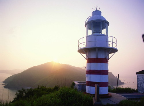
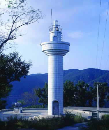
1925. Active; focal plane 80.5 m (264 ft); white flash every 5 s. 7.5 m (25 ft) round cylindrical steel or cast iron tower with lantern and gallery. Lighthouse painted white with narrow red horizontal bands. A photo is at the top of this page, a small photo is available, and Google has a satellite view. The island is a popular resort and the lighthouse is one of the attractions. Dēngtǎshān ("Lighthouse Hill") was known historically as Mangshan ("Snake Hill"). Tours are said to be available from Dāndōng. Located on a small island off the east end of Dàlùdǎo, an island about 30 km (18 mi) west southwest of Dāndōng (Donggou), China's easternmost port. Site status unknown. ARLHS PRC-078; CN-1030; Admiralty P4076.

Dàlián Region: Zhuānghé District Lighthouses

The sub-provincial city (fùshĕngjí) of Dàlián occupies the southern portion of the Liáodōng Peninsula. The county-level city of Zhuānghé is the largest and northeasternmost of the 10 districts into which Dàlián is divided. Facing the northwestern coast of Korea Bay, it has a population of about 900,000 and includes major port facilities.

Zhuānghé Harbor Lighthouses
Huángquán Pier
2007. Active; focal plane 18 m (59 ft); white light, 3 s on, 3 s off. 10 m (33 ft) round barbell-shaped fiberglass tower colored with red and white horizontal bands. No photo available but Google has a satellite view. Located at the end of the L-shaped coal unloading pier. Site and tower closed. CN-1040.28; Admiralty P4075.8.
Huángquán Range Front
2007. Active; focal plane 35 m (115 ft); continuous red light. 29 m (95 ft) steel post centered on a square building. No photo available but Google has a satellite view. This range guides vessels approaching a long coal unloading pier that serves a large power plant about 25 km (15 mi) east of central Zhuānghé. Located on a platform on the west side of the pier. Site and tower closed. CN-1040.3; Admiralty P4075.7.
Huángquán Range Rear
2007. Active; focal plane 57 m (187 ft); continuous red light. 54 m (177 ft) steel post. No photo available but Google has a satellite view. Located at the base of the Huángjiāquán pier. Site and tower closed. CN-1040.32; Admiralty P4075.71.
Zhuānghé Gǎng Breakwater
Date unknown. Active; focal plane about 8.5 m (28 ft); continuous red light. 6 m (20 ft) round barbell-shaped fiberglass tower. No photo available but Google has a fuzzy satellite view. Located on the elbow of the east breakwater of Zhuānghé's traditional harbor. Site and tower closed. CN-1050.41; Admiralty P4075.5.

Shíchéng Township Lighthouses
* Shíchéngdǎo
Date unknown. Active; focal plane 11 m (36 ft); red light, 1 s on, 1 s off. 8 m (26 ft) round cylindrical concrete tower painted with red and white horizontal bands. No photo available but Google has a distant satellite view. Located at the end of the ferry pier at the north end of Shíchéngdǎo, an island about 8 km (5 mi) south of Zhuānghé. Accessible only by boat. Site open, tower closed. CN-1050.55; Admiralty P4075.4.
* Shíchéngdǎo Matou
Date unknown. Active; focal plane 10.5 m (34 ft); green light, 2 s on, 3 s off. 8 m (26 ft) round cylindrical concrete tower painted with red and white horizontal bands. No photo available but Google has a distant satellite view. Located at the end of a pier at a small port on the east side of Shíchéngdǎo. Accessible only by boat. Site open, tower closed. CN-1050.6; Admiralty P4075.2.
Dàwángjiādǎo (Tawangchia Tao)
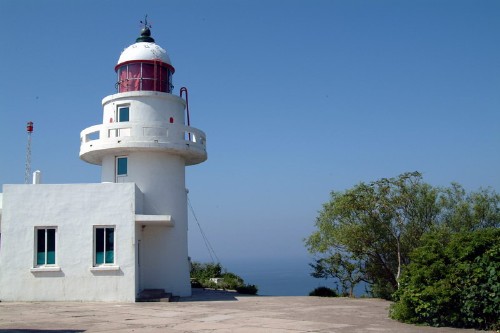
1939. Active; focal plane 108 m (354 ft); white flash every 10 s. 10 m (33 ft) round concrete tower with lantern and gallery, rising from the front of a 1-story concrete keeper's house. A City of Zhuānghé photo is at the top of this page, an aerial view is available, and Google has a satellite view. Dàwángjiādǎo is an island about 25 km (15 mi) southeast of Zhuānghé. Located on the south side of the island, within the Dàwángjiādǎo Scenic Area. Tours to the island are available from Zhuānghé. Site open, tower closed. ARLHS PRC-079; CN-1051; Admiralty P4075.

Dàlián Region: Pǔlándiàn District Lighthouses

The Pǔlándiàn District is to the west of the Zhuānghé District. It has a relatively short coastline; the only port facility is a new ferry port at Píkǒu serving many of the islands of Chánghǎi County.

Píkǒu Subdistrict Lighthouse
Píkǒu (Píkǒuda Jiāo)
2004. Active; focal plane 22 m (72 ft); white flash every 12 s. 22 m (72 ft) round white concrete tower with double gallery; an external stairway spirals around the tower to reach the first gallery. A photo is at right) and Bing has a satellite view. Located on a shoal about 5 km (3 mi) south southeast of Píkǒu, a small port about 70 km (45 mi) northeast of Dàlián. Accessible only by boat. Site open, tower closed. CN-1061.1; Admiralty P4067.5.


Píkǒu Light, Pǔlándiàn
Unattributed photo, no longer online, probably by MSA

* Píkǒu Kègǔnmǎtóu (Passenger Pier) (2)
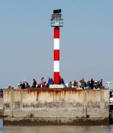
Date unknown. Active; focal plane about 21 m (69 ft); continuous light, white, red or green depending on direction. Approx. 17 m (56 ft) round tower mounted on a square concrete base. Tower painted with red and white horizontal bands. Sam Wang's photo is at right and Google has a satellite view. The 2016 Chinese light list describes a shorter tower. Located on the east pier at the Píkǒu ferry terminal. Accessible by walking the pier. Site open, tower closed. CN-1061.3; Admiralty P4067.41.
* Píkǒu Gǎng Sǎnhuòmǎtóu (Bulk Cargo Pier) (2)
Date unknown. Active; focal plane about 21 m (69 ft); continuous light, white, red or green depending on direction. Approx. 17 m (56 ft) round tower mounted on a square concrete base. Tower painted with red and white horizontal bands. No photo available but Google has a satellite view. Despite its name this appears to be a second passenger pier. The 2016 Chinese light list describes a shorter tower. Located on the west pier at the Píkǒu ferry terminal. Accessible by walking the pier. Site open, tower closed. CN-1061.12; Admiralty P4067.4.

Dàlián Region: Chánghǎi County (Wàichángshān Islands) Lighthouses

Chánghǎi County includes the Outer Changshan (Wàichángshān) Islands, which form a loose archipelago of some 112 islands and reefs on the west side of Korea Bay, extending southeastward from Zhuānghé and eastward from Dàlián. Many of the islands are inhabited. Chángshān means "Long Mountain," so these are the Outer Long Mountain Islands.

Dàchángshān Town Lighthouses
Dàchángshān (Big Changshan) and Xiǎochángshān (Little Changshan) and are the two largest, northernmost, and most populated of the islands. Both are aligned east to west. A bridge connects the west end of Xiǎochángshān and the east end of Dàchángshān. The islands lie off Píkǒu in the Pǔlándiàn District.

Xīcǎotuózi (2)
1985 (station established 1956). Active; focal plane 25 m (82 ft); white flash every 6 s. 10.5 m (35 ft) round cylindrical concrete tower with gallery, painted white. No photo available but Google has a distant satellite view. A sibling of the Huángshíjiǎo lighthouse. Located on the western tip of Dàchángshān. Site status unknown. CN-1060; Admiralty P4068.

Passenger Pier Light, Píkǒu, October 2010
Google Maps photo by Sam Wang
Yuǎnyángtuózi (2?)
Date unknown. Active; focal plane about 20 m (66 ft); red light, pattern unknown. Approx. 8 m (26 ft) round concrete tower painted with red and white horizontal bands. Xj Liu has a 2022 view from the sea and Google has a satellite view. A skeletal tower near the lighthouse is presumably an older light. Located on a small island off the northwest coast of Dàchángshān. Site status unknown. CN-1059.6; Admiralty P4068.07.
Jiǎoliudǎo
Date unknown. Active; focal plane 25 m (82 ft); red flash every 6 s. 8 m (26 ft) square white concrete tower. No photo available but Bing has an indistinct satellite view. Located on an islet about 4 km (2.5 mi) off the eastern tip of Dàchángshān. Accessible only by boat. Site status unknown. CN-1054; Admiralty P4068.1; NGA 18210.
Dàjiāo
Date unknown. Active; focal plane 4.5 m (15 ft); six quick white flashes followed by one lone white flash every 10 s. 6 m (20 ft) round concrete tower, upper half painted yellow and lower half black. No photo available but Google has a very distant satellite view. Located at the south end of a shoal off the southeast coast of Dàchángshān Dǎo. Accessible only by boat. Site status unknown. CN-1056; Admiralty P4068.085.
Huángshíjiāo (2)
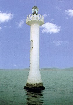
1985 (station established 1965). Active; focal plane 10 m (33 ft); white flash every 3 s. 13 m (43 ft) round cylindrical concrete tower with lantern and gallery, painted white. An MSA photo is at right and Google has a satellite view. This lighthouse marks a shoal off the principal port of Dàchángshān Dǎo. Accessible only by boat. Site status unknown. CN-1058; Admiralty P4066.43.
Shuāngshíjiāo (Double Rock Reef)
Date unknown. Active; focal plane 17 m (56 ft); red flash every 4 s. 12 m (39 ft) round red concrete tower. No photo available but Google has a satellite view. Located on a reef about 500 m (0.3 mi) south southeast of the Huángshíjiāo light. Accessible only by boat. Site status unknown. CN-1057; Admiralty P4066.42.
Jièbātuózi (3)
Date unknown (station established 1956). Active; focal plane 73 m (240 ft); two white flashes every 6 s. 6.5 m (21 ft) round barbell-shaped concrete tower with gallery, mounted on a stone base. Lighthouse painted with red and white horizontal bands. Baike.com has very distant view, Sam Wang has a distant view from the sea, and Google has a distant satellite view. The second (1987) light was on a cylindrical tower. Located on the highest point of a small island off the southern tip of Dàchángshān. The island is connected to the mainland of Dàchángshān by a breakwater pier. Site status unknown. CN-1059; Admiralty P4066.4.

Huángshíjiǎo Light, Chánghǎi
PRC Maritime Safety Administration photo

Xiǎochángshān Town Lighthouses
Xīběijiǎo (Xijia Jiao)
2009. Active; focal plane 28 m (92 ft); white light, 2.5 s on, 2.5 s off. 8 m (26 ft) square white concrete tower. No photo available but Google has a satellite view. Located on the northwestern tip of Xiǎochángshān. Site status unknown. CN-1055.72; Admiralty P4068.092.
Dàtuózi (Yingda Tuozi)
Date unknown. Active; focal plane 44 m (144 ft); white flash every 4 s. 6.5 m (21 ft) round cylindrical concrete tower with gallery, painted white. No photo available but Google has a satellite view. Located on an island off the northeastern tip of Xiǎochángshān. Site status unknown. CN-1053; Admiralty P4068.2.
Lùquānjiǎo
Date unknown. Active; focal plane 54 m (177 ft); two white flashes every 10 s. 10 m (33 ft) round concrete tower, painted white. No photo available but Google has a distant satellite view. Located at the eastern tip of Bǎshāodǎo, a small island off the eastern tip of Xiǎochángshān. Site status unknown. CN-1052; Admiralty P4070.
Xīwān (Xida Wan)
1962. Active; focal plane 40 m (131 ft); flash every 4 s, white or green depending on direction. 4.5 m (15 ft) square pyramidal stone tower attached to a small stone equipment room. Access to the light is by stone steps on one side of the pyramid. Entire beacon painted white. No photo available but Google has a satellite view. Located on a rocky promontory sheltering the harbor of Nánshāntún, the principal port of Xiǎochángshān, on the south side of the island. Site status unknown. CN-1055; Admiralty P4068.093.
Dàhámajiāo (Big Frog Rock)
Date unknown. Active; focal plane 15.5 m (51 ft); three white flashes every 6 s. 6 m (20 ft) round concrete tower colored with red and white horizontal bands. No photo available but Google has a satellite view. Presumably the islet looks like a frog from certain angles. Located on an islet about 1.5 km (1 mi) southwest of the western tip of Xiǎochángshān. Accessible only by boat. Site status unknown. CN-1055.74; Admiralty P4068.097.

Guǎnglùdǎo Town Lighthouses
Guǎnglùdǎo ("Many Deer Island") is a relatively large island lying to the southwest of Dàchángshān and Xiǎochángshān.

Húlúdǎo (Hulutao)
1957. Active; focal plane 71 m (233 ft); white flash every 4 s. 8.5 m (28 ft) round cylindrical concrete tower with gallery, painted white. No photo available but Google has a satellite view. Another sibling of the Huángshíjiǎo lighthouse, this light guides vessels in the passage between the islands and the mainland. Located on an island off the northwestern coast of Guǎnglùdǎo. Site status unknown. CN-1062; Admiralty P4066.3.
Guǎnglùshān (2)
1987 (station established 1957). Active; focal plane 89 m (292 ft); white flash every 6 s. 10.5 m (35 ft) round cylindrical concrete tower with gallery, painted white. No photo available but Google has a distant satellite view. Another sibling of the Huángshíjiǎo lighthouse. Located on an island off the southeastern coast of Guǎnglùdǎo. Site status unknown. CN-1061; Admiralty P4067; NGA 18208.

Zhāngzidǎo Town Lighthouses
Zhāngzidǎo Town includes several small islands located about 16 km (10 mi) south of Xiǎochángshān. The passage between these islands and the more northern Chángshān islands is called the Wàichángshān Strait.

Dōngdāliándǎo (East Daliandao) (2)
1987 (station established 1958). Active; focal plane 43 m (141 ft); white flash every 4 s. 10.5 m (35 ft) round cylindrical concrete tower with gallery, painted white. No photo available but a Bing satellite view probably shows the lighthouse. Another sibling of the Huángshíjiǎo lighthouse. A square pyramidal tower next to the present lighthouse is similar to the Xīwān light (see above) and is presumably the 1958 light tower. Located on an island northeast of Zhāngzidǎo, about 27 km (17 mi) south of Xiǎochángshān. Site status unknown. CN-1066; Admiralty P4066.48.
Jiājiǎo (Zhāngzidǎo Northwest)
2009. Active; focal plane 14 m (46 ft); white light, 2 s on, 2 s off. 10 m (33 ft) round white concrete tower. No photo available but Google has a satellite view. Located on the northern tip of Zhāngzidǎo. Site status unknown. CN-1067.131; Admiralty P4066.435.
Shābāo Gǎng Cargo Pier (2)
Date unknown. Active; focal plane about 14 m (46 ft); one long green flash every 6 s. Approx. 12 m (39 ft) round green concrete tower. Jim Morrison has a 2022 street view and Google has a satellite view. Located on the north pier of a harbor near the northeastern corner of Zhāngzidǎo. Site status unknown. CN-1067.14; Admiralty P4066.44.
Shābāo Gǎng Passenger Pier
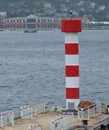
Date unknown (recent). Active; focal plane about 16 m (52 ft); red light, pattern unknown. Approx. 14 m (46 ft) round concrete tower painted with red and white horizontal bands. Jim Morrison's street view is at right and Google has a satellite view. Located on the south pier of a harbor near the northeastern corner of Zhāngzidǎo. Site status unknown. Not in the 2016 CN list and not listed by the Admiralty.

Bādǒuyínzi Light, Hǎiyángdǎo
PRC Maritime Safety Administration Wēnzhōu Office photo
Zhāngzidǎo (2)
1987 (station established 1957). Active; focal plane 145 m (476 ft); white flash every 4 s. 12.5 m (41 ft) round cylindrical concrete tower with gallery, painted white. No photo available but Bing has a distant satellite view of the station. Another sibling of the Huangshijiǎo lighthouse. A square pyramidal tower next to the present lighthouse may be the 1957 lighthouse; instead of a lantern, the solar panels are now mounted on its roof. Located at the southeastern tip of Zhāngzidǎo. Site status unknown. CN-1067; Admiralty P4066.45.

Hǎiyángdǎo Town Lighthouses
The outermost of the Chanshan Islands, Hǎiyángdǎo is about 25 km (15 mi) due east of Zhāngzidǎo. The name Hǎiyángdǎo means "Oceanic Island."

Bādǒuyínzi (Hǎiyángdǎo) (3)
1998 (station established 1915). Active; focal plane 61.5 m (202 ft); white flash every 5 s. 13 m (43 ft) round cylindrical tile-covered concrete tower with gallery. Entire lighthouse is white. 1-story wood keeper's house. The MSA's photo is at right and Google has a satellite view. The original Japanese station, called "Hai Yung Tau," was apparently discontinued in favor of the present Hǎiyángdǎo station in 1932. The present station was established in 1949, according to MSA. Located on the south side of the harbor entrance, on the west side of Hǎiyángdǎo. Site status unknown. ARLHS PRC-080; CN-1065; Admiralty P4066.5; NGA 18211.
Hǎiyángdǎo (2)
Date unknown (station established 1932). Active; focal plane 50 m (164 ft); white flash every 6 s. 8 m (26 ft) round cylindrical concrete tower centered on a round 1-story concrete equipment room. Lighthouse painted white. No photo available but Google has a distant satellite view. Located near the northwestern corner of Hǎiyángdǎo. Site status unknown. CN-1063; Admiralty P4066.55.

Information available on lost lighthouses:

Notable faux lighthouses:


Bādǒuyínzi Light, Hǎiyángdǎo
PRC Maritime Safety Administration Wēnzhōu Office photo

Adjoining pages: East: Western North Korea | Southeast: Southeastern Liáoníng

Return to the Lighthouse Directory index | Ratings key

Posted February 25, 2008. Checked and revised June 30, 2023. Lighthouses: 33. Site copyright 2023 Russ Rowlett and the University of North Carolina at Chapel Hill.