Lighthouses of China: Southeastern Liáoníng

The People's Republic of China (中华, Zhōnghuá in Chinese) has a lengthy coastline, many large harbors, and a large number of lighthouses. During the colonial period of the late 19th and early 20th centuries Western powers occupied a number of locations in China and built lighthouses, many of which survive. In more recent years the People's Republic has developed modern ports throughout the country and built many lighthouses to serve them.

China is divided into 23 provinces and 11 other province-level regions of various special types. Liáoníng Province is in northeastern China at the northern end of the Chinese coast. A principal geographical feature of the province is the Liáodōng (Liaotung) Peninsula, which projects into the northern end of the Yellow Sea, separating Korea Bay on the east from Liáodōng Bay on the west. The major port complex of Dàlián is near the end of the peninsula on the eastern side.

During the colonial period Russia and Japan vied for control of this strategically located area. In 1898 Russia leased the Dàlián area from China, but Japan conquered the Russian colony during the Russo-Japanese War of 1904-05. In 1931 Japan invaded northeast China and incorporated Liáoníng (then called Fengtian) into the puppet state of Manchukuo until the end of the Second World War in 1945. Soviet troops then occupied Dàlián; the city was returned to Chinese sovereignty in 1950 but Soviet troops remained until they were withdrawn in 1955. The city was called Darien in English and Japanese (大連) and Dalniy (Дальний) in Russian.

Liáoníng is divided into 14 regions, 12 classified as prefectural-level cities (dìjíshì) and 2 as sub-provincial-level cities (fùshĕngjí). The regions are subdivided into districts classified at various administrative levels. This page includes lighthouses of the four districts of the Dàlián region that include the main harbor districts.

Lighthouses in China are maintained by the PRC Maritime Safety Administration. There are regional offices in each province.

There are many languages and dialects spoken in China, but Standard Chinese, often called Mandarin, is official. The pīnyīn system for transliterating Chinese into Latin characters is now the international standard but some locations continue to be known also under the spellings of older transliteration systems. The Chinese word for a lighthouse is dēngtǎ (灯塔). In Standard Chinese jiāo (formerly chiao) is a reef or rock, jiǎo is a cape or headland, dǎo (tao) is an island; (tsu) or tuózi ("lump") is a small island, hǎi is a sea, wān is a bay, hǎixiá is a strait, or jiāng is a river, hékǒu ("river mouth") is an estuary, and gǎng (kang) is a harbor.

Names formerly used by the Japanese administration are shown in brackets {}.

ARLHS numbers are from the ARLHS World List of Lights. CN numbers are Chinese light list numbers, where available. Admiralty numbers are from volume P of the Admiralty List of Lights & Fog Signals. U.S. NGA List numbers are from Publication 112.
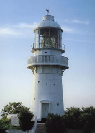
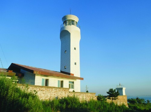
Laotieshan Light
Lǎotiěshān Light, Lǚshùn
PRC Maritime Safety Administration photo
General Sources
Ten Most Beautiful Lighthouses in Dàlián and Lǚshùn
A blog with excellent recent photos.
Online List of Lights - China
Photos by various photographers posted by Alexander Trabas.
Chinese English Pinyin Dictionary
A useful tool for juggling the representations of Chinese names.
Leuchttürme Chinas auf historischen Postkarten
Historic postcard views posted by Klaus Huelse.
Navionics Charts
Navigation chart for Dàlián.
Dàlián City: Jīnzhōu District East Coast Lighthouses
The Jīnzhōu District of Dàlián lies north of the city center; it has a population of more than one million and is a major port in its own right. This Jīnzhōu (金州) is easily confused with the city of Jīnzhōu (锦州) on the west side of Liáodōng Bay. Lighthouses of that city are listed on the Western Liáoníng page.
Nándàquān
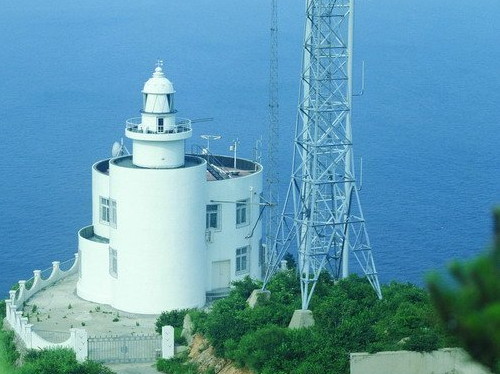
1995. Active; focal plane 57 m (187 ft); two white flashes every 10 s. 22 m (72 ft) square cylindrical concrete tower with lantern and gallery, attached to a large 1-story keeper's house complex. Lighthouse painted white. An MSA photo is at right, the "10 most beautiful" blog has photos (lighthouse #5), and Bing has a satellite view. Although the lighthouse was built in 1990 it was not activated until 1995. Located at the tip of a narrow peninsula on the north side of Dàyào Wān about 30 km (19 mi) northeast of Dàlián. Site status unknown. ARLHS PRC-044; CN-1072; Admiralty P4065; NGA 18225.
Dàyào Wān North Entrance North Side
Date unknown. Active; focal plane 20 m (66 ft); green light, 3 s on, 3 s off. 20 m (66 ft) round cylindrical concrete tower with gallery, painted with black and white horizontal bands. No photo available but Bing has a satellite view. Located on the north detached breakwater of Dàyào Wān, south of the Nandaquan lighthouse. Accessible only by boat. Site and tower closed. CN-1072.4; Admiralty P4065.3; NGA 18225.3.
Dàyào Wān North Entrance South Side
1995?. Active; focal plane 20 m (66 ft); red light, 3 s on, 3 s off. 20 m (66 ft) round cylindrical concrete tower with gallery, painted white. The light is in the far background of the photo of the harbor entrance below right and Bing has a satellite view. Located at the north end of the detached north breakwater of Dàyào Wān (bay), opposite the Nandaquan lighthouse. Accessible only by boat. Site and tower closed. CN-1072.8; Admiralty P4065.4; NGA 18225.5.
Nandaquan Light
Nándàquān Light, Jīnzhōu
PRC Maritime Safety Administration photo
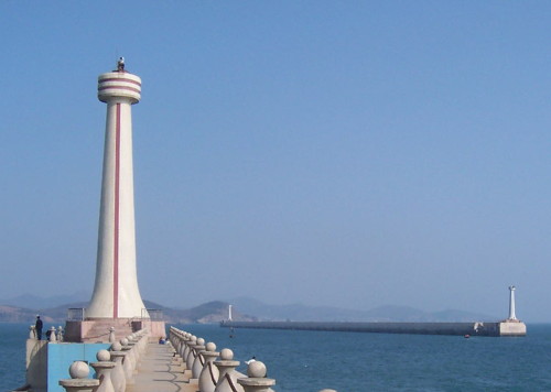
Dàyào Wān North Breakwater South End (Dayaowan Zulangdi)
1995. Active; focal plane 26.5 m (87 ft); green flash every 5 s. 22 m (72 ft) round cylindrical concrete tower with gallery, painted white. The light is at the right in the photo of the harbor entrance at right and Bing has a satellite view. Located at the south end of the detached north breakwater of Dàyào Wān. Accessible only by boat. Site and tower closed. ARLHS PRC-024; CN-1072.9; Admiralty P4065.5; NGA 18226.2.
Dàyào Wān Wharf (Pier 13)
Date unknown. Active; focal plane 15 m (49 ft); 10 m (33 ft) round fiberglass tower colored with red and white horizontal bands. No photo available but Google has a satellite view. Located on the wharf of the container terminal on the south side of Dàyào Wān. Site and tower closed. CN-1078.45; Admiralty P4066.2.
Dàyào Wān South Breakwater
Date unknown. Active; focal plane 27 m (89 ft); continuous red light. 22 m (72 ft) round cylindrical concrete tower with lantern and gallery. The lighthouse is white with narrow red vertical stripes. A photo is at right and Bing has a satellite view. Located at the end of the breakwater, a working pier on the south side of Dàyào Wān. Site and tower closed. CN-1073; Admiralty P4066; NGA 18226.
Dàlián Xīngǎng North Oil Pier
Date unknown. Active; focal plane 17 m (56 ft); continuous red light. 12 m (39 ft) round tapered fiberglass tower colored with red and white horizontal bands. No photo available but Bing has a satellite view. Xīngǎng menas "New Harbor." Located at the end of the pier of the oil terminal. Site and tower closed. CN-1084.1; Admiralty P4059.2; NGA 112-18227.
Dàlián Xīngǎng Oil Terminal Outer Pier (2)
1985 (station established 1976). Active; focal plane 17 m (56 ft); continuous green light. 17 m (56 ft) round tapered fiberglass tower colored with red and white horizontal bands. No photo available but Bing has a satellite view. NGA lists a framework tower at this location. Located at the end of a long pier sheltering the oil terminal, southeast of the Dàyào Wān Breakwater and northwest of the Shātuózi lighthouse. Site and tower closed. CN-1084; Admiralty P4059.3; NGA 18229.
Dayao Wan Breakwater Lights
Dàyào Wān South Breakwater Light, Jīnzhōu, November 2006
ex-Panoramio photo copyright haili4603; permission requested
Dàlián Xīngǎng Oil Terminal Inner Pier
Date unknown. Active; focal plane 22 m (72 ft); white light, 4 s on, 4 s off. 12 m (39 ft) round tapered fiberglass tower colored with red and white horizontal bands. No photo available but Bing has a satellite view. Located at the end of the inner pier of the oil terminal. Site and tower closed. CN-1083.5; Admiralty P4059.4.
Dàlián Xīngǎng Oil Terminal Operations Pier (Service Boat Pier)
Date unknown. Active; focal plane 11 m (36 ft); continuous red light. 10 m (33 ft) round white concrete tower. No photo available but Bing has a satellite view. Located at the end of a pier at the oil terminal. Site and tower closed. CN-1085; Admiralty P4059.5; NGA 18231.
Nánsānliàngchējiāo (Xiǎn Jiāo) (3)
1987 (station established 1928). Active; focal plane 21 m (69 ft); white flash every 5 s. 21 m (69 ft) round hourglass-shaped fiberglass tower mounted on a hexagonal cylindrical concrete pedestal. Fiberglass tower painted with red and white horizontal bands, concrete base unpainted. The original light was on a 10 m (33 ft) tower, and the second lighthouse was built in 1961. No photo available and Google has only a fuzzy satellite view of the location. The alternate name Xiǎn Jiāo simply means "Dangerous Reef." Located on a rocky reef about 25 km (15 mi) southeast of Dàlián. Accessible only by boat. Site and tower closed. ARLHS PRC-062; CN-1080; Admiralty P4060; NGA 18222.
Shātuózi
1976. Active; focal plane 37 m (121 ft); white flash every 6 s. 37 m (121 ft) round cylindrical concrete tower with lantern and gallery, painted white with red trim. An MSA photo is at right and an excellent 2010 closeup is available. The lighthouse was built at the tip of the blunt peninsula on the south side of Dàyào Wān. In 1986 it was necessary to reinforce the foundation, presumably against wave action. More recently breakwaters were built to enclose the location of the lighthouse, and the area was filled and developed as part of the oil terminal. Google's satellite view shows the lighthouse is now surrounded by huge tanks. Site and tower closed. ARLHS PRC-081; CN-1086; Admiralty P4059; NGA 18228.

Shātuózi Light, Jīnzhōu
PRC Maritime Safety Administration photo
Bulk Cargo Pier Head
Date unknown. Active; focal plane 15 m (49 ft); continuous red light. 10 m (33 ft) round metal (?) tower painted with red and white horizontal bands. No photo available but Bing has a satellite view. Located at the end of a pier southwest of Shātuózi. Site and tower closed. CN-1086.04; Admiralty P4059.18; NGA 18233.
Jiǔcàituózi
1973. Active (?); listed focal plane 18 m (59 ft); two white flashes every 6 s.. 8.5 m (28 ft) round cylindrical concrete tower centered on a round 1-story concrete equipment room. Lighthouse painted white. No photo available but Bing has an indistinct satellite view. This light was formerly located on a small island southwest of the Shātuózi lighthouse, marking the north side of the entrance to Dàlián Wān. The area is now developed as an oil terminal and if the light remains active it cannot have any navigational value. Site and tower closed. ex-CN-1087; Admiralty P4058.5; NGA 18234.
Běiliang Gǎng Breakwater
2009(?). Active; focal plane 30 m (98 ft); continuous green light. 20 m (66 ft) round fiberglass tower colored with red and white horizontal bands. C.P. Wang has a distant view and Google has a satellite view. Located on a short breakwater on the north side of Dagushan Bay, opposite central Dàlián. Site status unknown. CN-1086.7; Admiralty P4056; NGA 18235.3.
Běiliang Gǎng Oil Pier
Date unknown. Active; focal plane 16 m (52 ft); two white flashes every 10 s. 10 m (33 ft) round barbell-shaped fiberglass tower, colored with black and white horizontal bands. No photo available but Google has a satellite view. Located at the end of a pier about 800 m (1/2 mi) northwest of the Beilang Gang Breakwater lighthouse. Site status unknown. CN-1086.69; Admiralty P4053; NGA 18234.1.

Dàlián City: Offshore Approach Lighthouses
Yuándǎo (Round Island)
1925 (substantially rebuilt in 1949). Active; focal plane 66 m (217 ft); white flash every 15 s. 20 m (66 ft) round cylindrical concrete tower with lantern and gallery, attached to a 1-story keeper's house. Lighthouse painted white, lantern roof red. An MSA photo is at right and a 2016 visitor account has several photos (fourth and seventh photos on the page) but the island is barely visible in Google's satellite view. Heavily damaged during World War II, the lighthouse was repaired and operated by the Soviet Union from 1949 to 1955. Located on a small island far out in Korea Bay, about 50 km (30 mi) east southeast of Dàlián. Accessible only by boat. Site and tower closed. ARLHS PRC-073; CN-1096; Admiralty P4064; NGA 18212.

Yuándǎo Light, Korea Bay
PRC Maritime Safety Administration photo
Dàsānshāndǎo
1905. Active; focal plane 81 m (266 ft); white flash every 10 s. 12 m (39 ft) round stone tower, painted white. Fog siren (4 blasts every 30 s). A 2019 photo is at right and Google has a satellite view. Construction of this historic lighthouse began in 1903, presumably by the Russian government then in control of Dàlián. According to MSA, the lighthouse was refurbished in 1947, a fog signal was added in 1958, and in 1994 action was taken to stabilize the slope around the lighthouse. Dàsānshāndǎo is an island off the southern entrance to Dàlián Bay, about 25 km (15 mi) east southeast of the city. Located at the southern tip of the island. Accessible only by boat. Site and tower closed. ARLHS PRC-023; CN-1097; Admiralty P4058; NGA 18220.

Dàlián City: Gānjǐngzi District (Commercial Harbor) Lighthouses
Héshàngdǎo Main (General Cargo Pier) Breakwater
Date unknown. Active; focal plane about 16 m (52 ft); red light, 3 s on, 3 s off. 10 m (33 ft) round fiberglass tower colored with red and white horizontal bands. No photo available but Morteza Taheri has a very distant street view across the harbor and Google has a satellite view. Héshàngdǎo is a former island, now joined to the mainland, at the northern end of Dàlián harbor. Located at the end of the main breakwater of the harbor. Site and tower closed. CN-1087.3; Admiralty P4047.6.
Zhongyuan Chuanwu East Breakwater
Date unknown. Active; focal plane 17 m (56 ft); green flash every 3 s. 12 m (39 ft) white tower; NGA describes it as a metal tower but it looks more like a concrete tower in Google's satellite view. No photo available but Paulo Morbeck has a very distant aerial view. Located on the east breakwater of the Zhongyuan Chuanwu harbor. CN-1094.03; Admiralty P4045.3; NGA 18284.


Dàsānshāndǎo Light, Dàlián, September 2019
unattributed Sohu.com photo

Zhongyuan Chuanwu West Breakwater North
Date unknown. Active; focal plane 17 m (56 ft); red flash every 3 s. 12 m (39 ft) tower painted with red and white horizontal bands; NGA describes it as a metal tower but it looks more like a concrete tower in Google's satellite view. No photo available. Located at the northeast end of a short detached breakwater of the Zhongyuan Chuanwu harbor. CN-1094.04; Admiralty P4045.25; NGA 18285.
Zhongyuan Chuanwu West Breakwater South
Date unknown. Active; focal plane 17 m (56 ft); white flash every 5 s. 10 m (33 ft) tower painted with black and white horizontal bands; NGA describes it as a metal tower but it looks more like a concrete tower in Google's satellite view. No photo available. Located at the southwest end of a short detached breakwater of the Zhongyuan Chuanwu harbor. CN-1094.05; Admiralty P4045.24; NGA 18285.1.
Liaohaixun Breakwater
Date unknown. Active; focal plane 12 m (39 ft); white light, 2 s on, 2 s off. 10 m (33 ft) round fiberglass tower colored with black and white horizontal bands. No photo available but Google has a satellite view. Located at the end of a pier in the Zhongyuan Chuanwu harbor. Site and tower closed. CN-1094.5; Admiralty P4045.23; NGA 18283.
Gānjǐngzi (Kanchingtzu) {Kanseishi} Oil Wharf
Date unknown. Active; focal plane 16 m (52 ft); white light, 2 s on, 2 s off. 10 m (33 ft) round fiberglass tower colored with black and white horizontal bands. Zhang Rongtian has a distant view from the harbor (tower to the left of the smoking chimneys) and Bing has a satellite view. Located at the end of the pier. Site and tower closed. CN-1122.05; Admiralty P4045.22; NGA 18279.1.
Gānjǐngzi (Kanchingtzu) {Kanseishi} Wharf (2)
1997 (station established 1930). Active; focal plane 12.5 m (41 ft); continuous green light. 12 m (39 ft) tapered round fiberglass tower, painted white. No photo available but Bing has a satellite view. Located at the end of the longest pier of Dàlián's old harbor. Site status unknown. CN-1124; Admiralty P4044; NGA 18280.

Dàlián City: Xīgǎng District (West Harbor) Lighthouses
Jīnggǔ Pierhead (Mǎnhuá Wharf)
1930s. Active; focal plane 12 m (39 ft); continuous red light. 9 m (30 ft) round cast iron tower with lantern and gallery. The lighthouse should be painted red but it appears rusted in the "10 most beautiful" blog's photos (lighthouse #7). Google has a satellite view. This historic lighthouse was built on a chemical products pier but the present pier appears to be for general bulk cargo. The light was probably relocated to the end of an extension of the original pier. Located near Bīnhǎi (Coastal) Park north of the shipyard. Site status unknown but the lighthouse can be seen from nearby. CN-1131.1; Admiralty P4042.8.
Hēizuǐzi Breakwater East End
Date unknown. Active; focal plane 9 m (30 ft); white flash every 3 s. 8 m (26 ft) white concrete tower. No photo available but Bing has an indistinct satellite view. Located at the east end of a detached breakwater in the Hēizuǐzi harbor on the north side of downtown Dàlián. Accessible only by boat. Site and tower closed. CN-1112; Admiralty P4034.
Dàgǎng Běikǒuxī (North Entrance West Side)
1915. Active; focal plane 19 m (62 ft); continuous red light. 19 m (62 ft) tile-covered tower with lantern and gallery. Lighthouse painted white, lantern red. This lighthouse appears (on the left) above the bow of the aircraft carrier Liáoníng in Zhang Rongtian's photo (seen at right) and Bing has a satellite view. The lighthouse was "transformed" in 1964, presumably by adding the tile covering. Located at the end of the west breakwater of Dàlián. Site and tower closed. CN-1108; Admiralty P4028; NGA 18268.
 

North Entrance West (left) and East Side Lights, Dàlián, November 2006
Google Maps photo by Zhang Rongtian
 

Dàlián City: Zhōngshān District (Downtown) Lighthouses
Dàgǎng Běikǒudōng (North Entrance East Side) (?)
1915. Removed in 2020 but still listed with focal plane 19 m (62 ft); continuous red light. 19 m (62 ft) tile-covered tower with lantern and gallery. Lighthouse painted white, lantern red. This lighthouse appears (on the right) above the bow of the aircraft carrier Liáoníng in Zhang Rongtian's photo (seen above right) and Bing has a satellite view. The two North Entrance lights are seen at the bottom of an aerial view. The lighthouse was "transformed" in 1964, presumably by adding the tile covering. It was removed in 2020 so that the breakwater could be shortened by about 400 m (1/4 mi). No new light has been announced as of July 2022. Located at the west end of the detached main breakwater of Dàlián. Accessible only by boat. Site and tower closed. CN-1107; Admiralty P4026; NGA 18264.
Dàgǎng Dōngkǒuběi (East Entrance North Side) (Dàlián Wān)
1913. Active; focal plane 13 m (43 ft); white light, 6 s on, 6 s off. 13 m (43 ft) round tapered stone tower with lantern and gallery, painted white. The "10 most beautiful" blog has photos (lighthouse #1), Zhang Rongtian has a photo, this light is at the right of Ye Liao's photo of the South Side Light, Huelse has a historic postcard view, and Google has a satellite view. Located at the east end of the detached main breakwater of Dàlián, on the north side of the Dàlián peninsula. Accessible only by boat. Site and tower closed. ARLHS PRC-022; CN-1105; Admiralty P4022; NGA 18256.
* Dàgǎng Dōngkǒunán (East Entrance South Side)
1913. Active; focal plane 11 m (36 ft); red light, 6 s on, 6 s off. 13 m (43 ft) round tapered stone tower with lantern and gallery, painted red. A photo by Uwe Aranas is at right, the Dalian Lighthouse blog has a photo (just over halfway down the page), the "10 most beautiful" blog has photos (lighthouse #1), Ye Liao has a closeup photo, Zhang Rongtian has a drone view, Huelse has a historic postcard view showing a long-vanished signal tower behind the lighthouse, and Google has a satellite view. Located at the end of the east breakwater of Dàlián. Site and tower closed, but the lighthouse can easily be viewed from shore. CN-1106; Admiralty P4020; NGA 18260.

East Entrance South Side Light, Dàlián, March 2012
Wikimedia photo by CEphoto, Uwe Aranas / CC-BY-SA-3.0
#Dàlián Oil Pier # 2 (2)
1965 (station established 1932). Removed, apparently in 2009. This was an 11 m (36 ft) round concrete tower, painted white, located at the end of the longer pier of the former Dàlián oil terminal, on the northeastern edge of the city. A recent Google satellite view shows that the entire pier and terminal have disappeared in a newly filled area. ex-CN-1122; ex-Admiralty P4018; ex-NGA 18244.
Huángbáizuǐ {Kohakushi} (2)
1996 (station established 1925). Active; focal plane 95 m (312 ft); flash every 5 s, alternately red and white. 16 m (52 ft) round cylindrical concrete tower, attached to a round 2-story coast guard or harbor control building. Entire structure painted white. An MSA photo is at right, Qi Wang has a photo and a more distant view, the "10 most beautiful" blog has photos (lighthouse #3), and Bing has a satellite view. This light is the landfall light for Dàlián harbor. Located on a sharp, rocky promontory on the northeast corner of the Dàlián peninsula, about 12 km (7.5 mi) east of the center of the city. Site status unknown. ARLHS PRC-032; CN-1098; Admiralty P4010; NGA 18236.
* Lǎohǔtān Wān Breakwater (2?)
Date unknown. Active; focal plane about 27 m (89 ft); green (?) flash every 4 s. Approx. 24 m (79 ft) ornate square tower with lantern. Matthew Stinson has a photo, the "10 most beautiful" blog has photos (lighthouse #2) showing the tower with a white light, Jorge Huang Li has a photo, and Bing has a satellite view. This lighthouse copies the design of the historic lighthouse of Bremerhaven, Germany. The 2016-17 Chinese light list describes a 9 m (30 ft) tower. Located on a breakwater in Lǎohǔtān Bay on the south side of the Dàlián peninsula. Site open; the tower may be open as well. CN-1139; Admiralty P3988.
Huang
Huángbáizuǐ Light, Dàlián
PRC Maritime Safety Administration Wēnzhōu Office photo
Lǎohǔtān Wān (Tiger Beach)
Date unknown. Apparently inactive. Approx. 15 m (49 ft) round cylindrical concrete tower with lantern and gallery, covered with white ceramic tiles. The small lantern is red. Dmitry Klimenko has a 2009 photo, the "10 most beautiful" blog has photos (lighthouse #6) and a distant view are available, and Bing has a satellite view. We need additional information on this lighthouse. Located on a promontory on the west side of the entrance to Lǎohǔtān Bay. Site open, tower closed. Not charted by Navionics and not listed by the Admiralty.
* Xīnghǎi
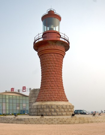
Date unknown. Active (unofficial); continuous (?) white light. Approx. 17 m (56 ft) round hourglass-shaped stone stone tower with lantern and gallery. Lighthouse painted red. Brian Yap's photo is at right, Jo Manolo has a nighttime photo of the lighthouse in action, a 2009 closeup and a 2016 closeup are available, Fei Mohammed has a street view, and Google has a satellite view. We need information on the history of this interesting lighthouse. Xīnghǎi, on the south side of the Dàlián peninsula, has tourist facilities including a cruise ship terminal and swimming beach. Located on the west side of the harbor entrance at Xīnghǎi. Site open, tower closed. Not charted by Navionics and not listed by the Admiralty.

Dàlián City: Southern Offshore Lighthouses
Lǎopiāndǎo
2001. Active; focal plane 88 m (289 ft); white flash every 4 s. 8 m (26 ft) white round concrete tower. No closeup photo available but Google has a satellite view. The area is included in a marine ecosystem preserve. Located on a small but high island about 10 km (6 mi) south of Xinghai. Accessible only by boat. Site status unknown. CN-1143; Admiralty P3985.
Yùyán (Yu Yan, Gugan, Encounter Rock)
1925. Active; focal plane 20 m (66 ft); white light, 1.5 s on, 2.5 s off. 16 m (52 ft) round concrete tower with lantern and gallery, painted white. No photo available and the rock is not seen in Google's satellite view. The lighthouse was restored in 1998 and MSA repaired the lighthouse when it failed in October 2012. Located on a rocky reef about 35 km (22 mi) south of Dàlián. Accessible only by boat. Site and tower closed. ARLHS PRC-072; CN-1145; Admiralty P4062; NGA 18216.
Xinghai Light
Xīnghǎi Light, Dàlián, October 2006
Flickr Creative Commons photo by Brian Yap

Dàlián City: Lǚshùnkǒu District East Coast Lighthouses
Lǚshùn is a port near the southern tip of the Liáodōng Peninsula. The city is north of the Laotieshan mountain, with port facilities on both coasts of the peninsula. The history of the city is complex. The British, who had outposts on the peninsula as early as the 1850s, called the city Port Arthur. The Japanese occupied it in 1894-95 during the First Sino-Japanese War but they were forced to give it up by the Western powers. In 1898 Russia occupied the port and made it the terminus of the Chinese Eastern Railway. The city was then re-occupied by the Japanese in 1905 and remained under their control until the end of the Second World War. During this period the city was known as Ryojun (旅順) in Japanese, but it continued to be called Port Arthur in the west. Soviet troops occupied the city in 1945 and remained in control until 1953. The lights of Lǚshùn's main harbor are missing from international light lists and Navionics has no data for the harbor; this is because the harbor is a major base for the Chinese Navy. We need more information about these lighthouses.
Lǎohǔwěi West (Lǚshùn) (2)
Date unknown. Active; focal plane about 45 m (148 ft); light characteristic unknown. Approx. 21 m (69 ft) rectangular concrete tower with lantern and gallery, painted white. An MSA photo is at right, Vladislav Nikitenko has a photo, the "10 most beautiful" blog has photos (lighthouse #9), Zhāng Yùhuī has a distant view across the bay, and Google has a satellite view and a very distant street view. The lighthouse is part of a large complex of buildings, probably a military base. The modern lighthouse replaced a much smaller light seen to the right of the tower in MSA's photo at right. Located on a promontory on the west side of the entrance to the eastern (Korea Bay) harbor of Lǚshùn. Site and tower closed. Not charted by Navionics and not listed by the Admiralty.
Lǚshùn Range Lights (Front, Middle, and Rear)
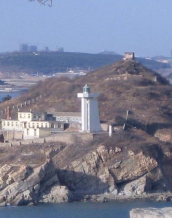
Date unknown. Active; focal planes and light characteristics unknown. Three round towers with lantern and gallery; towers painted white, lanterns red. Guó Qīnglóng has a photo showing all three lighthouses and Google has satellite views of the front, middle, and rear lights. Located on a hillside facing the harbor entrance. Site status unknown. Not charted by Navionics and not listed by the Admiralty.

Dàlián City: Lǚshùnkǒu District West Coast Lighthouses
** Lǎotiěshān (Liaotieshan Xijiao, Port Arthur)
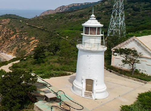
1893. Active; focal plane 100 m (328 ft); two white flashes every 30 s. 14 m (46 ft) round cylindrical cast iron tower with lantern and gallery. Lighthouse painted white. Original 1st order Fresnel lens. Several keeper's houses and other light station buildings. An MSA photo is at the top of this page, Lliu Yun has a good closeup photo, the "10 most beautiful" blog has photos (lighthouse #4), another closeup photo and a photo of the station are available, Mapio.net has a photo, the lighthouse appears on a postage stamp, and Google has a satellite view. Prefabricated in France, this historic lighthouse marks the southwestern tip of the Liáodōng Peninsula. The lighthouse was installed by Chinese authorities but was managed by Russia (1898-1904), Japan (1904-1945), and the Soviet Union (1945-1955) before being returned to Chinese control. Today the lighthouse is a popular attraction for visitors to Lǚshùn. Located about 12 km (7.5 mi) southwest of Lǚshùn (known as Port Arthur during the colonial period). Accessible by road. Site open, tower closed. . ARLHS PRC-038; CN-1175; Admiralty P3986; NGA 18312.
Lǚshùn Xīngǎng East Outer Breakwater
2012. Active; focal plane 23 m (75 ft); green light, 3 s on, 3 s off. 6 m (20 ft) round concrete tower, colored with green and white horizontal bands. No photo available but Google has a satellite view. Lǚshùn Xīngǎng (New Harbor) is a port developed around Yángtóu (Sheephead) Bay on the west side of the city. Located at the end of the outer breakwater of the Lǚshùn Xīngǎng harbor. Site status unknown. CN-1176.109; Admiralty P3984.69.
Lüshun Light
Lǚshùn Light, Lǚshùn
PRC Maritime Safety Administration photo
Lǚshùn Xīngǎng East Breakwater
Date unknown. Active; focal plane about 7 m (23 ft); continuous green light. 6 m (20 ft) round concrete tower with lantern and gallery. Tower covered with white ceramic tiles; lantern painted green. No photo available but Google has a satellite view. Located at the end of the inner east breakwater of the Lǚshùn Xīngǎng harbor. Site status unknown. CN-1176.1; Admiralty P3984.6.
Lǚshùn Xīngǎng West Breakwater
Date unknown. Active; focal plane about 7 m (23 ft); continuous red light. 6 m (20 ft) round concrete tower with lantern and gallery. Tower covered with red ceramic tiles; lantern painted red. No photo available but Google has a satellite view. Located at the end of the west inner breakwater of the Lǚshùn Xīngǎng harbor. Site status unknown. CN-1176; Admiralty P3984.5.
Lǚshùn Xīngǎng West Outer Breakwater
2012. Active; focal plane 23 m (75 ft); white light, 3 s on, 3 s off. 6 m (20 ft) round concrete tower, colored with red and white horizontal bands. No photo available but Google has a satellite view. Located at the end of the outer breakwater of the Lǚshùn Xīngǎng harbor. Site status unknown. CN-1176.11; Admiralty P3984.7.
Shuāngdǎowān
Date unknown. Google's satellite view reveals a substantial lighthouse with lantern and gallery on the breakwater of Shuāngdǎowān, a sheltered bay about 15 km (9 mi) north of Xīngǎng harbor. No other information is available about this lighthouse. Not charted by Navionics and not listed by the Admiralty.
Shédǎo (Snake Island, Xiǎolóngshān, Little Dragon Mountain) {Sho-ryu-san-to}
1932. Active; focal plane 69 m (226 ft); white flash every 4 s. 8.5 m (28 ft) round concrete tower, painted white. An MSA photo is at right and Google has a distant satellite view. Shédǎo (Snake Island) is an island about 10 km (6 mi) off the northwestern point of the tip of the Liáodōng Peninsula. The island is a national nature reserve. Located at the northwestern tip of the island. Accessible only by boat. Site status unknown. CN-1177; Admiralty P3984; NGA 18316.

Shédǎo (Xiǎolóngshān) Light, Lǚshùn
PRC Maritime Safety Administration photo
 

Information available on lost lighthouses:

Notable faux lighthouses:

Adjoining pages: Northeast: Eastern Liáoníng | Northwest: Southwestern Liáoníng

Return to the Lighthouse Directory index | Ratings key

Posted February 25, 2008. Checked and revised July 6, 2023. Lighthouses: 53. Site copyright 2023 Russ Rowlett and the University of North Carolina at Chapel Hill.