Lighthouses of China: Qínhuángdǎo, Héběi

The People's Republic of China (中华, Zhōnghuá in Chinese) has a lengthy coastline, many large harbors, and a large number of lighthouses. During the colonial period of the late 19th and early 20th centuries Western powers occupied a number of locations in China and built lighthouses, many of which survive. In more recent years the People's Republic has developed modern ports throughout the country and built many lighthouses to serve them.

The country is divided into 23 provinces and 11 other province-level regions of various special types. Héběi (formerly spelled Hopei or Hopeh) is the province of northern China surrounding the provincial-level metropolitan districts of Běijīng and Tiānjīn. Its coast faces eastward on the Bohai Sea, a northwestward extension of the Yellow Sea lying west of the Liaodong and Shandong peninsulas.

Héběi is divided into eleven prefectural-level cities. This page describes the lighthouses of the prefectural-level city of Qínhuángdǎo, China's second busiest port after Shànghǎi, located in the northeastern corner of Héběi. Qínhuángdǎo is divided into four districts and three counties.

There are many languages and dialects spoken in China, but Standard Chinese, often called Mandarin, is official. The pīnyīn system for transliterating Chinese into Latin characters is now the international standard but some locations continue to be known also under the spellings of older transliteration systems. The Chinese word for a lighthouse is dēngtǎ (灯塔). In Standard Chinese jiāo (formerly chiao) is a reef or rock, jiǎo is a cape or headland, dǎo (tao) is an island; (tsu) or tuózi ("lump") is a small island, hǎi is a sea, wān is a bay, hǎixiá is a strait, or jiāng is a river, hékǒu ("river mouth") is an estuary, and gǎng (kang) is a harbor.

Lighthouses in China are maintained by the PRC Maritime Safety Administration. The administration is organized in regional administrations; Qínhuángdǎo lighthouses fall under Tianjin MSA.

ARLHS numbers are from the ARLHS World List of Lights. CN numbers are Chinese light list numbers. Admiralty numbers are from volume P of the Admiralty List of Lights & Fog Signals. U.S. NGA List numbers are from Publication 112.

General Sources
Online List of Lights - China
Photos by various photographers posted by Alexander Trabas.
World of Lighthouses - China
Photos by various photographers available from Lightphotos.net.
Chinese English Pinyin Dictionary
A useful tool for juggling the representations of Chinese names.
Leuchttürme Chinas auf historischen Postkarten
Historic postcard views posted by Klaus Huelse.
Navionics Charts
Navigation chart for Qínhuángdǎo.

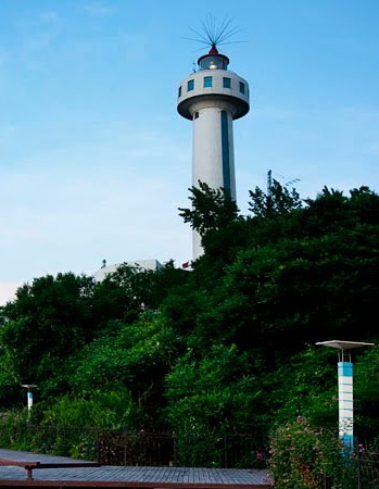
Nanshantou Light
Nánshāntóu Light, Qínhuángdǎo, August 2010
ex-Panoramio Creative Commons photo by Y.W. Jiang

Shānhǎiguān District (Qínhuángdǎo North Harbor) Lighthouses

Shānhǎiguān ("sea mountain pass") is famous as the place where the Great Wall of China comes down to the sea. The modern harbor is just to the east of this major tourist attraction.

Shānhǎiguān South Pier
Date unknown. Active; focal plane about 16 m (52 ft); green light, 3 s on, 3 s off. Approx. 14 m (56 ft) round white tower. No photo available but Google has a satellite view. Located on a pier in an area of new development east of the shipyard basin in Shānhǎiguān. Site and tower closed. CN-1251.683; Admiralty P3955.23.
Shānhǎiguān No. 17 Pier
Date unknown. Active; focal plane about 16 m (52 ft); green flash every 4 s. Approx. 14 m (56 ft) round red tower. No photo available but Google has a satellite view. Located on an inner pier in an area of new development east of the shipyard basin in Shānhǎiguān. Site and tower closed. CN-1251.687; Admiralty P3955.235.
Shānhǎiguān East Breakwater South Head
Date unknown. Active; focal plane about 20 m (66 ft); white light, 3 s on, 3 s off. Approx. 17 m (56 ft) round white tower. No photo available but Google has a satellite view. Located at the end of the long east breakwater of the shipyard basin in Shānhǎiguān. Site and tower closed. CN-1251.681; Admiralty P3955.22.
Shānhǎiguān East Breakwater Middle
Date unknown. Active; focal plane about 16 m (52 ft); white flash every 4 s. Approx. 13 m (43 ft) round white tower painted with red (?) and white horizontal bands. No photo available but Google has a satellite view. Located in an elbow of the long east breakwater of the shipyard basin in Shānhǎiguān. Site and tower closed. CN-1251.682; Admiralty P3955.21.
Shānhǎiguān West Breakwater
Date unknown. Active; focal plane about 15 m (49 ft); red flash every 4 s. Approx. 12 m (39 ft) round white tower. No photo available but Google has a satellite view. Located at the end of the west (inner) breakwater of the shipyard basin in Shānhǎiguān. Site and tower closed. CN-1251.68; Admiralty P3955.
Shānhǎiguān
Date unknown. Active; focal plane about 20 m (66 ft); green flash every 2 s. Approx. 14 m (46 ft) round white tower painted with red and white horizontal bands. The light is at the far left in a photo by Nguyễn Đức Dũng and Google has a satellite view. Located in an elbow of the long east breakwater of the shipyard basin in Shānhǎiguān. Site and tower closed. CN-1251.84; Admiralty P3956.5.
* Shānhǎiguān Sightseeing Pier
Date unknown. Active; focal plane about 20 m (66 ft); red light, pattern unknown. Approx. 15 m (49 ft) round tower. No photo available but Google has a satellite view (a portion is seen at right). Located on the pier just north of the mouth of the Shí (Rock) River. Site open, tower closed. Admiralty P3954.97.
Shānhǎiguān Yacht Club North Breakwater
Date unknown. Active; focal plane about 13 m (43 ft); red light, pattern unknown. Approx. 10 m (33 ft) round tower. No photo available but Google has a satellite view. The yacht club is being built on Báilù Island just off shore on the west side of the mouth of the Shí (Rock) River. Located on the north breakwater of the harbor. Site status unknown. Admiralty P3954.968.
Shānhǎiguān Yacht Club South Breakwater
Date unknown. Active; focal plane about 13 m (43 ft); green light, pattern unknown. Approx. 10 m (33 ft) round tower. No photo available but Google has a satellite view. Located on the south breakwater of the harbor. Site status unknown. Admiralty P3954.967.
 

Shānhǎiguān Sightseeing Pier, Shānhǎiguān
Google Maps satellite view
 

Hǎigǎng District (Qínhuángdǎo Main Harbor) Lighthouses

Eastern Harbor Lighthouses
Qínhuángdǎo HSA Breakwater
Date unknown. Active; focal plane about 13 m (43 ft); green light, pattern unknown. Approx. 10 m (33 ft) round tower. No photo available but Google has a satellite view. Located on the east breakwater of the Maritime Safety (hǎi shàng ānquán) Authority basin at the east edge of the Main Harbor district. Site and tower closed. Admiralty P3954.9649.
Bóhǎi Chuánwū East Breakwater
Date unknown. Active; focal plane 10 m (33 ft); yellow flash every 4 s. 7 m (23 ft) round barbell-shaped white fiberglass tower. No photo available but Google has a satellite view. Located on the "boathouse" (chuánwū) pier in eastern Qínhuángdǎo. Site status unknown. CN serial 2110211.02; Admiralty P3954.964.
Bóhǎi Chuánwū East Breakwater Elbow
Date unknown. Active; focal plane 10 m (33 ft); red flash every 4 s. 7 m (23 ft) round barbell-shaped fiberglass tower colored with red and white horizontal bands. No photo available but Google has a satellite view. Located on the elbow of the boathouse pier. Site status unknown. CN serial 2110211.01; Admiralty P3954.9641.
Qínhuángdǎo Méisānqī Range Front (3 towers)
Date unknown. Active; focal plane 28 m (92 ft); continuous white light. Three 24 m (79 ft) square cylindrical skeletal towers painted white. No photo available but Google has a satellite view. NGA calls this the middle light, making an offshore buoy the front light. Located on the west edge of the coal wharf. Site and tower closed. CN-1263.37, Admiralty P3953.81 (centerline); CN-1263.41,P3953.821 (west channel limit); and CN-1263.39, P3953.823 (east channel limit); NGA 18452.6.
Qínhuángdǎo Méisānqī Range Rear (3 towers)
Date unknown. Active; focal plane 49 m (161 ft); continuous white light. Three 48 m (157 ft) square cylindrical skeletal towers painted white. No photo available but Google has a satellite view. Located at the northern edge of the Meisiqi terminal, 1235 m (3/4 mi) northeast of the front light. Site and tower closed. CN-1263.38, Admiralty P3953.82 (centerline); CN-1263.42; P3953.822 (west channel limit); and CN-1263.4, P3953.824 (east channel limit); NGA 18452.7.
Qínhuángdǎo Méisānqī Pier No. 1
Date unknown. Active; focal plane 18 m (59 ft); green flash every 2 s. 12 m (39 ft) round fiberglass tower painted with green and white horizontal bands. No photo available but Google has a satellite view. Located at the end of the main pier of the Meisiqi terminal in eastern Qínhuángdǎo. Site and tower closed. CN-1271.81; Admiralty P3954.926.
Qínhuángdǎo Méisānqī New Pier
Date unknown. Active; focal plane 17 m (56 ft); continuous green light. 12 m (39 ft) round white concrete tower. A distant aerial view is at right and Google has a satellite view. Located on a pier at the Méisānqī terminal in eastern Qínhuángdǎo. Site and tower closed. CN-1263.43; Admiralty P3953.9; NGA 18452.8.
Qínhuángdǎo Méisānqī Inner Pier
Date unknown. Active; focal plane 17 m (56 ft); two white flashes every 6 s. 11 m (36 ft) round white concrete tower. A distant aerial view is at right and Google has a satellite view. Located on an inner pier at the Méisānqī terminal in eastern Qínhuángdǎo. Site and tower closed. CN-1263.44; Admiralty P3954.65; NGA 18453.
Qínhuángdǎo MSA (Hǎishìjú) Large Pier
Date unknown. Active; focal plane 16 m (52 ft); two white flashes every 4 s. 11 m (36 ft) round fiberglass tower painted with red and white horizontal bands. No photo available but Google has a satellite view. Located on an inner pier west of the Méisānqī terminal in eastern Qínhuángdǎo. Site and tower closed. CN-1263.45; Admiralty P3954.9; NGA 18453.2.

Méisānqī Inner Pier Light (left) and New Pier Light (right), Qínhuángdǎo
Port of Qínhuángdǎo photo

Eastern Approach Range Lighthouses
Qínhuángdǎo East Channel/Southeast Approach Range Common Front (2) (4 towers)
1984 (station established 1973). Active; focal plane 33 m (108 ft); continuous white light. 29 m (95 ft) octagonal cylindrical concrete tower topped by a control room. Lighthouse painted with red and white horizontal bands. No photo available but Google has a satellite view. The main lighthouse (CN-1274; Admiralty P3948; NGA 18448) is grouped with three secondary 29 m (95 ft) square skeletal lighthouses. These include a common east limit light (CN-1274; Admiralty P3948.103), a southeast range west limit light (CN-1276; Admiralty P3948.105), and an east range west limit light (Admiralty P3948.101). Located near a large tank farm on the east side of Qínhuángdǎo. Site and tower closed.
Qínhuángdǎo East Channel Range Rear (2) (3 towers)
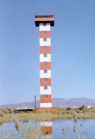
1984 (station established 1973). Active; focal plane 45 m (148 ft); white light, 3 s on, 2 s off. 44 m (144 ft) square cylindrical concrete tower topped by a control room. Lighthouse painted with red and white horizontal bands. An older MSA photo is at right and Google has a good satellite view. Skeletal towers to either side of the lighthouse carry lights defining the edges of the channel. Located in an industrial area about 1200 m (3/4 mi) north of the front light. Site and tower closed. CN-1273, Admiralty P3948.1 (centerline); CN-1277, P3948.102 (west limit); and CN-1275, P3948.104 (east limit); NGA 18452.
Qínhuángdǎo Southeast Approach (Shíwàndūnjí Hángdào) Range Middle (2?)
Date unknown. Active; focal plane 43 m (141 ft); white light, 2 s on, 4 s off. Approx. 39 m (128 ft) tapered square skeletal tower with gallery. No photo available but Google has a satellite view. The Chinese name means "Hundred Thousand Ton Ship Channel." Located in an industrial zone 1.95 km (1.2 mi) northwest of the front light. Site and tower closed. CN-1273.1; Admiralty P3948.11; NGA 18448.1.
Qínhuángdǎo Southeast Approach (Shíwàndūnjí Hángdào) Range Rear (3 towers)
Date unknown. Active; focal plane 58 m (190 ft); continuous white light. Approx. 45 m (148 ft) octagonal concrete tower carrying a large observation room. Lighthouse painted with red and white horizontal bands. No photo available but Google has a satellite view. Two tapered skeletal towers to the southeast, seen in another satellite view, define the edges of the channel. Located in an industrial zone 1.95 km (1.2 mi) northwest of the front light. Site and tower closed. CN-1273.2, Admiralty P3948.15, NGA 18448.2(centerline); P3948.106 (west limit); and CN-1273.3, P3948.107 (east limit).

Meiyiqi Harbor and Xīnkāi River Entrance Lighthouses
Qínhuángdǎo Fuel Oil Pier Outer Head (2)
1990 (station established 1976). Active; focal plane 11 m (36 ft); white flash every 3 s. 12 m (39 ft) round cylindrical concrete tower with gallery. Lighthouse painted white. No photo available but Google has a satellite view. The three oil pier lights appear to be identical. Located at the end of a long pier on the east end of the Qínhuángdǎo waterfront. Site and tower closed. CN-1266; Admiralty P3950.5; NGA 18432.
Qinhuangdao East Channel Middle Range Rear Light
Qínhuángdǎo East Channel Range Rear Light
PRC Maritime Safety Administration photo
Qínhuángdǎo Fuel Oil Pier Inner Head (2)
1990 (station established 1973). Active; focal plane 15 m (49 ft); continuous red light. 12 m (39 ft) round cylindrical concrete tower with gallery. Lighthouse painted white. No photo available but Google has a satellite view. Located at the end of a side pier on Fuel Oil Pier, about 600 m (0.4 mi) north of the Outer Head Light. Site and tower closed. CN-1267; Admiralty P3949.5; NGA 18424.
Qínhuángdǎo Fuel Oil Pier Innermost Head
1979. Active; focal plane 12 m (39 ft); red flash every 4 s. 12 m (39 ft) round cylindrical concrete tower with gallery. Lighthouse painted white. No photo available but Google has a satellite view. Located at the end of a side pier on Fuel Oil Pier, about 600 m (0.4 mi) north of the Outer Head Light. Site and tower closed. CN-1268; Admiralty P3950; NGA 18428.
Qínhuángdǎo Coal (Méièrqī) Pier
Date unknown. Active; focal plane about 15 m (49 ft); three white flashes, in a 2+1 pattern, every 6 s. Approx. 11 m (36 ft) round concrete tower with lantern and gallery painted with red (?) and white horizontal bands. No photo available but Google has a satellite view. Located at the end of a pier a short distance west of the oil piers. CN-1265.1; Admiralty P3950.3.
Qínhuángdǎo Xīnkāi Outer Channel Range Front
Date unknown. Active; focal plane 20 m (66 ft); white flash every 2 s . 18 m (59 ft) round cylindrical concrete tower painted with red and white horizontal bands. . No photo available but Google has a satellite view. Located on the waterfront just on the east bank of the mouth of the Xīnkāi River. Site status unknown. CN-1263.24; Admiralty P3937.5.
Qínhuángdǎo Xīnkāi Outer Channel Range Rear
Date unknown. Active; focal plane 32 m (105 ft); white flash every 2 s. 29 m (95 ft) tapered skeletal tower. No photo available but Google has a satellite view. Located in an industrial area on the east bank of the Xīnkāi River. Site and tower closed. CN-1263.25; Admiralty P3937.51.
Qínhuángdǎo East Entrance West Breakwater
2009. Active; focal plane 15 m (49 ft); red light, 1 s on, 1 s off. 13 m (43 ft) double post (ladder-like) steel tower with a large gallery and a triangular daymark at the top, painted white with red trim. No photo available but Google has an indistinct satellite view. Located at the end of a short breakwater on the west side of the mouth of the Xīnkāi River. Site and tower closed. CN-1263.23; Admiralty P3937.45.

Main Approach Range Lighthouses
Zhǔhángdào Yǐndǎo (Zhongxin Biao, Qínhuángdǎo Main Channel Range Subsidiary)
1986. Active; focal plane 16 m (52 ft); white light, 1 s on, 1 s off. 15 m (49 ft) round cylindrical concrete tower with lantern and gallery, mounted on a square concrete pier. Lighthouse painted with red and white horizontal bands. No photo available but Bing has a fuzzy satellite view. This is a "pre-front" light on the line of the Main Channel range. Located offshore about 2.5 km (1.5 mi) southeast of the Nánshāntóu lighthouse. Accessible only by boat. Site open, tower closed. CN-1278; Admiralty P3937.6; NGA 18420.
* Qínhuángdǎo Main Channel Range Front (2) (3 towers)
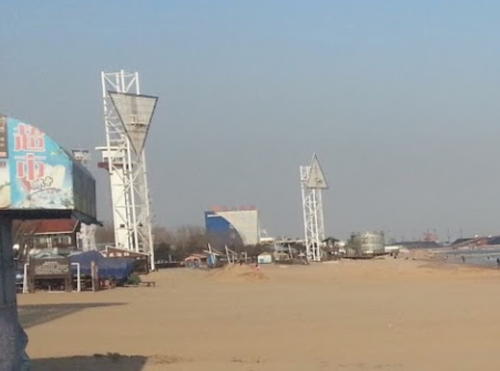
Date unknown (station established 1975). Active; focal plane 31 m (102 ft); continuous white light. 30 m (98 ft) square cylindrical concrete tower, painted white. The tower carries a large triangular daymark, point up. King Yin Chan has the photo at right (this tower is behind the west limit skeletal tower on the left) and Google has a satellite view. Located on the Qínhuángdǎo waterfront about 600 m (0.37 mi) northeast of the Nánshāntóu lighthouse. Site open, tower closed. CN-1279, Admiralty P3937.4 (centerline), NGA 18412; CN-1283, Admiralty P3937.411 (west limit); and CN-1281, Admiralty P3937.413 (east limit).
* Qínhuángdǎo Main Channel Range Rear (3 towers)
Date unknown (station established 1975). Active; focal plane 48 m (157 ft); white light, 2 s on, 2 s off. 47 m (154 ft) square cylindrical concrete tower topped by a control room. Lighthouse painted with red and white vertical stripes. No photo available but Google has a satellite view. Skeletal towers to either side of the lighthouse carry lights defining the edges of the channel. Located in downtown Qínhuángdǎo about 1.95 km (1.2 mi) north of the front light. Site open, tower closed. CN-1280, Admiralty P3937.41,NGA 18416 (centerline); CN-1284, Admiralty P3937.412 (west limit); and CN-1282, Admiralty P3937.414 (east limit).

Main Channel Range Front Lights, Qínhuángdǎo, December 2012
Google Maps photo by King Yin Chan

Downtown Qínhuángdǎo Lighthouses
* Nánshāntóu Tourist Pier
2009. Active; focal plane 15 m (49 ft); white light, 1 s on, 1 s off. 12 m (39 ft) square tower with lantern and gallery. Lighthouse painted white; the lantern roof is orange. A photo is at right, a 2016 photo and a 2014 closeup are available, and Google has a satellite view. This lighthouse replaced a light on a yellow post. Located at the end of a pier extending from a plaza at the north side of the Nánshāntóu headland. Accessible by walking the pier. Site open, tower closed. CN-1284.1; Admiralty P3937.2.
** Nánshāntóu (4)
1991 (station established 1890). Active; focal plane 59 m (194 ft); white flash every 15 s. 49 m (161 ft) round cylindrical concrete tower with lantern, gallery, and a circular observation room, adjoining a semicircular 2-story concrete harbor control building. Lighthouse painted white, lantern red. Y.W. Jiang's photo is at the top of this page, Mapio.net has photos, another photo and a street view are available, and Google has a satellite view. This is the landfall light for the port of Qínhuángdǎo. The original lighthouse was replaced in 1918 and another lighthouse was built under Japanese rule in 1942. The present lighthouse is somewhat endangered by erosion of the bluff on which it stands and there was a project in 1993 to stabilize this slope. Located on a promontory ("Nánshāntóu" means "South Mountain Head") on the Qínhuángdǎo waterfront, just east of the traditional harbor entrance. Site open; the observation level of the tower is probably open as well. ARLHS PRC-047; CN-1285; Admiralty P3937; NGA 18408.
Qínhuángdǎo South Breakwater
Date unknown. Active; focal plane 17 m (56 ft); white light occulting every 2 s. 11 m (36 ft) round fiberglass tower colored with green and white horizontal bands. No photo available but Google has a satellite view. Located on the south breakwater pier of the original Qínhuángdǎo harbor. Site and tower closed. CN-1289; Admiralty P3943.8; NGA 18456.
Qínhuángdǎo South Inner Pier
Date unknown. Active; focal plane 20 m (66 ft); continuous green light. 17 m (56 ft) square concrete tower painted with red (?) and white horizontal bands. No photo available but Google has a satellite view. Located on a pier north of the south breakwater. Site and tower closed. CN-1290; Admiralty P3943.9; NGA 18464.
Qínhuángdǎo Old Channel Range Front (3 towers)
Date unknown. Active; focal plane 22 m (72 ft); continuous white light. 21 m (69 ft) square pyramidal skeletal tower carrying a triangular daymark point up. Similar east and west limit towers flank the main lighthouse. No photo available but Google has a satellite view. Located on the waterfront at the original Qínhuángdǎo harbor. Site status unknown. CN-1292, Admiralty P3943, NGA 18440 (centerline); CN-1296, Admiralty P3943.11 (west limit); and CN-1294, Admiralty P3943.13 (east limit).

Nánshāntóu Tourist Pier Light, Qínhuángdǎo, 2009
Nipic.com Creative Commons photo by gremlin
Qínhuángdǎo Old Channel Range Rear (3 towers)
Date unknown. Active; focal plane and light characteristic unknown. Approx. 20 m (66 ft) square pyramidal skeletal tower carrying a triangular daymark point down. Similar east and west limit towers flank the main lighthouse. No photo available but Google has a satellite view. Located about 1 km (0.6 mi) north of the front light. Site status unknown. CN-1293, Admiralty P3943.1, NGA 18444 (centerline); CN-1297, Admiralty P3943.12 (west limit); and CN-1295, Admiralty P3943.14 (east limit).
Qínhuángdǎo Pier A
1982 (station established 1976). Active; focal plane 12 m (39 ft); continuous green light. 12 m (39 ft) round cylindrical concrete tower with gallery. Lighthouse painted white. No photo available but Google has a satellite view. The original light was removed after a ship collided with the pier in 1980. Located on the seaward corner of the main pier of Qínhuángdǎo's traditional harbor. Site status unknown. CN-1298; Admiralty P3945; NGA 18466.
Qínhuángdǎo Breakwater East End
1986. Active; focal plane 12 m (39 ft); red flash every 4 s. 10 m (33 ft) round tapered fiberglass tower, painted with red and white horizontal bands. No photo available, but Google has an indistinct satellite view. NGA describes the breakwater as being detached but it is now joined to land by a very broad industrial pier. Located at the east end of the main breakwater for Qínhuángdǎo's traditional harbor. Site and tower closed. CN-1297.1; Admiralty P3942; NGA 18454.

Western Harbor Lighthouses
Qínhuángdǎo West Channel Range Front Auxiliary
Date unknown (station established 1975). Active; focal plane 31 m (102 ft); continuous white light. 30 m (98 ft) square cylindrical concrete tower topped by a control room. Lighthouse painted with red and white horizontal bands. No photo available but Google has a satellite view. Located at the end of a pier in Qínhuángdǎo's traditional harbor. Site and tower closed. CN-1302; Admiralty P3941.151; NGA 18468.
Qínhuángdǎo West Channel Range Front (2) (3 towers)
Date unknown (station established 1975). Active; focal plane 34 m (112 ft); continuous white light. 31 m (131 ft) cylindrical tower topped by a control room. Lighthouse painted with red and white horizontal bands. No photo available but Google has a satellite view. Skeletal towers to the southwest and northeast of the lighthouse carry lights defining the edges of the channel. This lighthouse is on the site of the former rear range light. The new tower is apparently shorter than the old one, which had a height of 46 m (151 ft). Located within the harbor area about 1 km (0.6 mi) northwest of the front light. Site status unknown. CN-1299, Admiralty P3941.14 (centerline); CN-1305, Admiralty P3941.12 (west limit); and CN-1301, Admiralty P3941.16 (east limit).
Qínhuángdǎo West Channel Range Rear (3 towers)
Date unknown (2000 or later). Active; focal plane 50 m (164 ft); white light occulting once every 5 s. 46 m (151 ft) cylindrical tower topped by a control room. Lighthouse painted with red and white horizontal bands. No photo available but Google has a satellite view (a portion is seen at right). Skeletal towers on the north and south of the lighthouse carry lights defining the edges of the channel. Located on the east bank of the Táng river, next to an interchange of a new expressway. Site status unknown. CN-1300, Admiralty P3941.15 (centerline); CN-1307, Admiralty P3941.13 (west limit); and CN-1303, Admiralty P3941.17 (east limit); NGA 18472.
Qínhuángdǎo Breakwater West End
Date unknown. Active; focal plane 12.5 m (41 ft); continuous green light. 10 m (33 ft) square cylindrical concrete tower with gallery, painted white; lantern painted black. No photo available but Google has a satellite view. Located at the west end of the formerly-detached main breakwater. Site and tower closed. CN-1297.11; Admiralty P3942.1; NGA 18454.5.
Qínhuángdǎo PE Base East Breakwater
Date unknown. Active; focal plane about 12 m (39 ft); white light, 1 s on, 1 s off. Approx. 10 m (33 ft) square cylindrical concrete tower with gallery, painted white; lantern painted black. Sisavath Thepvongsa has a distant street view and Google has a satellite view. Located at the end of the main breakwater of a basin just west of the Táng River mouth. Site and tower closed. CN-1297.4; Admiralty P3941.65.
Qínhuángdǎo PE Base West Breakwater
Date unknown. Active; focal plane 14 m (46 ft); red flash every 2 s. Approx. 6 m (20 ft) square cylindrical concrete tower with gallery, painted white; lantern painted black. This light is behind the flag in Sisavath Thepvongsa's street view but Google has a satellite view. Located at the west end of the main breakwater. Site and tower closed. CN-1297.4; Admiralty P3941.66.

Qínhuángdǎo West Channel Range Rear Light, Qínhuángdǎo
Google Maps satellite view

South Coast Lighthouses

Běidàihé District Lighthouse
Jīnshānzuǐ (2)
1991 (station established 1954). Active; focal plane 52 m (171 ft); two white flashes every 6 s. 28 m (92 ft) square skeletal tower, lower half pyramidal and upper half cylindrical. Lighthouse painted white. No photo available but Google has an indistinct satellite view. The place name Jīnshānzuǐ means "golden spur." Located on a high promontory projecting into the gulf of Bohai about 12 km (7.5 mi) southwest of Qínhuángdǎo. Site status unknown, but this site is probably accessible by road. CN-1308; Admiralty P3936; NGA 18476.

Fǔníng District Lighthouses
** Xiānluó Dǎo
Date unknown. Active; focal plane 30 m (98 ft); two white flashes every 5 s. Approx. 36 m (118 ft) octagonal tower topped by a large round observation room. A waterslide spirals around the lower half of the tower; near the top two arms appear to support bungee jumping. A photo is at right, a 2008 photo and a 2016 photo are available, Xyan Sama has a street view, and Google has a satellite view. Needless to add, this is a recreational facility. Located on an artificial island, connected to shore by a chair lift, about 800 m (1/2 mi) off the beach at Yánghékǒu, a popular resort town. Site and tower open. CN-1308.1; Admiralty P3935.9.
* Yánghékǒu (2)
Date unknown. Active; focal plane about 60 m (200 ft); white flash ever 3 s. Light mounted atop an 18-story apartment building. Jiǎng Bīn has a photo and Google has a satellite view. The original light was an 11 m (36 ft) metal tower. Located on the east side of the mouth of the Yánghé River. Site open, tower closed. CN-1309; Admiralty P3935.8.

Chānglí County Lighthouse
* Běidàihé New District Ocean Park Tourist Pier
Date unknown. Active; focal plane about 20 m (66 ft); red light, pattern unknown. Approx. 16 m (52 ft) round concrete tower with lantern and gallery, painted with red and white horizontal bands. Xi Qin has a distant street view from shore and Google has a satellite view. Located at a seaside amusement park about 60 km (38 mi) southwest of Qínhuángdǎo. Presumably accessible by walking the pier. Site open, tower closed. Admiralty P3935.4.

Xiānluó Dǎo Light, Qínhuángdǎo, Seotember 2018
Google Maps photo by Legendary Fox

Information available on lost lighthouses:

Notable faux lighthouses:

Adjoining pages: North: Western Liaoning | South: Tianjin Area

Return to the Lighthouse Directory index | Ratings key

Posted March 5, 2008. Checked and revised July 26, 2023. Lighthouses: 50. Site copyright 2023 Russ Rowlett and the University of North Carolina at Chapel Hill.