Lighthouses of China: Western Liáoníng

The People's Republic of China (中华, Zhōnghuá in Chinese) has a lengthy coastline, many large harbors, and a large number of lighthouses. During the colonial period of the late 19th and early 20th centuries Western powers occupied a number of locations in China and built lighthouses, many of which survive. In more recent years the People's Republic has developed modern ports throughout the country and built many lighthouses to serve them.

The country is divided into 23 provinces and 11 other province-level regions of various special types. Liáoníng Province is in northeastern China at the northern end of the Chinese coast. A principal geographical feature of the province is the Liáodōng (Liaotung) Peninsula, which projects into the northern end of the Yellow Sea, separating Korea Bay on the east from Liáodōng Bay on the west.

Liáoníng is divided into 14 regions, 12 classified as prefectural-level cities (dìjíshì) and 2 as sub-provincial-level cities (fùshĕngjí). The regions are subdivided into districts classified at various administrative levels. This page includes lighthouses of the three prefectural-level cities of Pánjǐn, Jǐnzhōu, and Húludǎo, located in the southwestern corner of the province facing south and southeast on Liáodōng Bay, the northern arm of the Bohai Sea.

Lighthouses in China are maintained by the PRC Maritime Safety Administration. The administration is organized in regional administrations; Liáoníng lighthouses fall under the Liáoníng MSA, a branch office of the Tianjin MSA.

There are many languages and dialects spoken in China, but Standard Chinese, often called Mandarin, is official. The pīnyīn system for transliterating Chinese into Latin characters is now the international standard but some locations continue to be known also under the spellings of older transliteration systems. The Chinese word for a lighthouse is dēngtǎ (灯塔). In Standard Chinese jiāo (formerly chiao) is a reef or rock, jiǎo is a cape or headland, dǎo (tao) is an island; (tsu) or tuózi ("lump") is a small island, hǎi is a sea, wān is a bay, hǎixiá is a strait, or jiāng is a river, hékǒu ("river mouth") is an estuary, and gǎng (kang) is a harbor.

ARLHS numbers are from the ARLHS World List of Lights. CN numbers are Chinese light list numbers. Admiralty numbers are from volume P of the Admiralty List of Lights & Fog Signals. U.S. NGA List numbers are from Publication 112.

General Sources
Online List of Lights - China
Photos by various photographers posted by Alexander Trabas.
Chinese English Pinyin Dictionary
A useful tool for juggling the representations of Chinese names.
Leuchttürme Chinas auf historischen Postkarten
Historic postcard views posted by Klaus Huelse.
Navionics Charts
Navigation chart for Liáodōng Bay.

Dialongzui Light
Diaolongzui Light, Suízhōng, March 2013
ex-Panoramio photo copyright Yougu; used by permission

Pánjǐn Prefecture Lighthouses

Dàwā District Lighthouses
The prefectural-level city of Pánjǐn is located immediately to the west of Yíngkǒu at the northernmost head of the Bóhǎi Sea, separated from Yíngkǒu by the Liáo River. The city has a population of more than 3 million.

Yǒngyuǎn Jiǎo
Date unknown. Active; focal plane 11 m (36 ft); white flash every 6 s. 10 m (33 ft) square cylindrical skeletal tower, painted black. No photo available but Google has a satellite view. Located on the north side of an oxbow bend of the Liáo River. Site status unknown. CN-1225; Admiralty P3977; NGA 18378.
Yíngkǒu No. 2 Range Front
Date unknown. Active; focal plane 13 m (43 ft); continuous red light. 12 m (39 ft) square black skeletal tower. No photo available but Google has a satellite view. This range guides arriving vessels in Yíngkǒu. Located Located on the west bank of the river near the west end of the oxbow bend. Site status unknown. CN-1221; Admiralty P3976; NGA 18376.
Yíngkǒu No. 2 Range Rear
Date unknown. Active; focal plane 17 m (56 ft); continuous red light. 16 m (52 ft) square black skeletal tower. No photo available and the tower is hard to distinguish in Google's satellite view. Located on the west bank of the river 160 m (525 ft) north of the front light. Site status unknown. CN-1222; Admiralty P3976.1; NGA 18377.
Yíngkǒu West Channel Range Rear
Date unknown. Active; focal plane 26 m (85 ft); continuous white light. 28 m (92 ft) square skeletal tower, painted black and carrying a triangular daymark. No photo available but Google has a satellite view. Located on the west bank of the mouth of the Liáo River. Site status unknown. CN-1214; Admiralty P3972.51; NGA 18374.
Yíngkǒu West Channel Range Front
Date unknown. Active; focal plane 16 m (52 ft); continuous white light. 18 m (59 ft) square skeletal tower, mounted on a square platform supported by piles. Lighthouse painted black, and carrying a triangular daymark. No photo available but Google has a satellite view. Located in a lagoon on the west bank of the mouth of the Liao River, 650 m (0.4 mi) south of the rear light. Site status unknown. CN-1213; Admiralty P3972.5; NGA 18373.
Róngxìng East Breakwater
Date unknown. Active; focal plane 16 m (52 ft); green flash every 3 s. 12 m (39 ft) round concrete tower painted with green and white horizontal bands. No photo available but Google has a satellite view. Róngxìng is a new port being developed about 10 km (6 mi) west of Yíngkǒu. Located on the east breakwater at Róngxìng. Site status unknown. Admiralty P3969.
Róngxìng Middle (Yíndī) Breakwater
Date unknown. Active; focal plane 16 m (52 ft); white light, pattern unknown. 12 m (39 ft) round concrete tower. No photo available but Google has a satellite view. Located on what appears to be the old west breakwater, now the middle breakwater at Róngxìng. Site status unknown. Admiralty P3968.345.
Róngxìng West Breakwater
Date unknown. Active; focal plane 16 m (52 ft); red flash every 3 s. 12 m (39 ft) round concrete tower painted with red and white horizontal bands. No photo available but Google has a satellite view. Located on the east breakwater at Róngxìng. Site status unknown. CN serial 1410962; Admiralty P3968.35.
Róngxìng Range Front
2014. Active; focal plane 39 m (128 ft); continuous white light. 36 m (118 ft) round concrete tower with lantern and gallery, painted with red and white horizontal bands. No photo available but Google has a satellite view. Located at the edge of the main quay of Róngxìng. Site status unknown. CN-1236.42; Admiralty P3968.
Róngxìng Range Rear
2014. Active; focal plane 59 m (194 ft); continuous white light. 56 m (184 ft) round concrete tower with lantern and gallery, painted with red and white horizontal bands. No photo available but Google has a satellite view. Located at the west edge of the main quay of Róngxìng, about 2 km (1.25 mi) north of the front light. Site status unknown. CN-1236.43; Admiralty P3968.1.

Jǐnzhōu Prefecture Lighthouses

Línghé District Lighthouses
Wedged in the northwestern corner of the Bóhǎi Sea, the prefectural-level city of Jǐnzhōu is China's northernmost port. The prefecture's population is a little over 3 million.
Jǐnzhōu Gǎng Range Front (2 towers)
Date unknown. Active; focal plane 42 m (138 ft); continuous white light. Approx. 40 m (131 ft) concrete tower topped by a large observation or harbor control structure. No closeup photo available but Yuer Yu has a distant street view and Google has a good satellite view. This is the approach range for Jǐnzhōu. Ships entering the harbor must keep to the right in the narrow channel, so there is also a East Channel Limit Range Front light on a 23 m (85 ft) square skeletal tower; Google has a satellite view of that light. Located on the waterfront of Jǐnzhōu. Site status unknown. CN-1244.4, Admiralty P3966 (main light); CN-1244.42, P3966.12 (East Channel Limit light); NGA 18382.
* Jǐnzhōu Gǎng Range Rear (2 towers)
Date unknown. Active; focal plane 73 m (240 ft); continuous white light. Approx. 67 m (220 ft) concrete tower topped by a large observation or harbor control structure. A photo is at right, Yuer Yu has a distant street view, and Google has a good satellite view. Also seen in the photo at right is the East Channel Limit Range Rear Light on a 29.5 m (97 ft) square skeletal tower painted with red and white horizontal bands. Google has a satellite view of that light. Located on Bohai Street near the waterfront of Jǐnzhōu, 1.82 km (1.15 mi) north of the front lighthouse. Site open, tower status unknown. CN-1244.41, Admiralty P3966.1 (main light); CN-1244.43, P3966.121 (East Channel Limit light); NGA 18382.1.
Basin No. 5 Range Front
Date unknown. Active; focal plane 24 m (79 ft); continuous red light. Approx. 22 m (72 ft) round steel tower. No photo available but Google has a satellite view. This range guides vessels into the outer basin of Jǐnzhōu harbor. Located on the oil terminal quay. Site and tower closed. CN-1244.96; Admiralty P3966.5; NGA 18383.
Basin No. 5 Range Rear
Date unknown. Active; focal plane 28 m (92 ft); continuous red light. Approx. 25 m (85 ft) round steel tower. No photo available but Google has a satellite view. Located 110 m (360) east northeast of the front light. Site and tower closed. CN-1244.97; Admiralty P3966.51; NGA 18383.1.
Jǐnzhōu (Berth No. 301) South Breakwater
Date unknown. Active; focal plane 20 m (66 ft); two white flashes every 6 s. 10 m (33 ft) round barbell-shaped fiberglass tower colored with red and white horizontal bands. No photo available but Google has a satellite view. Located at the south end of the oil tanker berth. Site and tower closed. CN-1244.44; Admiralty P3965.66.

Jǐnzhōu Gǎng Range Rear Light, Jǐnzhōu, September 2011
unattributed Google Maps photo
Jǐnzhōu (Berth No. 301) North Breakwater
Date unknown. Active; focal plane 20 m (66 ft); two white flashes every 6 s. 10 m (33 ft) round barbell-shaped fiberglass tower colored with red and white horizontal bands. No photo available but Google has a satellite view. Located at the north end of the oil tanker berth. Site and tower closed. CN-1244.45; Admiralty P3965.665.
Sāngǎngchì (Basin No. 3) Range Front
Date unknown. Active; focal plane 36 m (118 ft); continuous white light. 32 m (105 ft) square skeletal tower with three galleries. No photo available but Google has a satellite view. This range guides vessels into new facilities on the west side of Jǐnzhōu harbor. Site status unknown. CN-1244.436; Admiralty P3965.668.
Sāngǎngchì (Basin No. 3) Range Rear
Date unknown. Active; focal plane 46 m (148 ft); continuous white light. 42.5 m (139 ft) square skeletal tower with three galleries. No photo available but Google has a satellite view. Located about 400 m (1/4 mi) north northwest of the front light. Site status unknown. CN-1244.437; Admiralty P3965.6681.

Húludǎo Prefecture Lighthouses

The prefectural-level city of Húludǎo is located at the western end of Liáoníng Province along the northwestern shore of the Bóhǎi Gulf. Formerly called Jǐnxī, the prefecture has a population of nearly 3 million.

Lónggǎng District Lighthouse
Located just to the south of the Jǐnzhōu harbor, this district includes the oddly-shaped Húludǎo ("Gourd Island") peninsula for which the prefecture is named.

Jǐnzhōu Gǎng Outer Channel Range Front
Date unknown. Active; focal plane 34 m (112 ft); continuous white light. 34 m (112 ft) square skeletal tower mounted on a platform supported by piles. No photo available but Bing has a satellite view. This is the outer approach range for Jǐnzhōu harbor. Located about 2.5 km (1.5 mi) off the Húludǎo peninsula. Accessible only by boat. Site open, tower closed. CN-1244.301; Admiralty P3965.6.
Jǐnzhōu Gǎng Outer Channel Range Rear
Date unknown. Active; focal plane 55 m (180 ft); continuous white light. 55 m (180 ft) square skeletal tower mounted on a platform supported by piles. No photo available but Bing has a satellite view. Located about 1.25 km (3/4 mi) north of the front light. Accessible only by boat. Site open, tower closed. CN-1244.302; Admiralty P3965.601.
Húludǎo Gāojiǎo (High Point)
Date unknown. Active; focal plane 128 m (420 ft); two white flashes every 12 s. 10 m (33 ft) square masonry tower with lantern and gallery, rising from a 1-story keeper's house. Surprisingly no photos of this historic lighthouse are available but Google has a satellite view. Located on the tip of a peninsula about 15 km (9 mi) east of Jīnxī on the northwest coast of Liáodōng Bay. Site status unknown. CN-1245.901; Admiralty P3965.5; NGA 18380.
Húludǎo East Breakwater
Date unknown. Active; focal plane 12.5 m (41 ft); green flash every 3 s. 9 m (30 ft) round concrete tower. No photo available but Google has a satellite view. Located at the end of the short east breakwater of Húludǎo. Site status unknown. CN-1247; Admiralty P3965.52.
Húludǎo South Breakwater
Date unknown. Active; focal plane 12.5 m (41 ft); red flash every 3 s. 9 m (30 ft). Approx. 10 m (33 ft) round concrete tower. No photo available but Google has a satellite view. Located at the end of the south (main) breakwater of Húludǎo. Site status unknown. CN-1246; Admiralty P3965.54.
Húludǎo Main Channel Range Front
Date unknown. Active; focal plane 60 m (197 ft); continuous white light. 55 m (180 ft) tapered square skeletal tower. This is the approach range for Húludǎo. No photo available but Google has a satellite view. Located on the waterfront west of the main harbor entrance. Site status unknown. CN-1248.12; Admiralty P3965.574.
Húludǎo Main Channel Range Rear
Date unknown. Active; focal plane 80 m (262 ft); continuous white light. Approx. 25 m (82 ft) round cylindrical concrete tower. No photo available but Google has a satellite view that appears to show a solid tower. Located on a hillside about 1200 m (3/4 mi) northwest of the front light. Site status unknown. CN-1248.13; Admiralty P3965.5741.
Húludǎo Inner Channel Range Front
Date unknown. Active; focal plane 27 m (89 ft); continuous white light. 20 m (66 ft) square skeletal tower. This is the entrance range for Húludǎo. No photo available but Google has a satellite view. Located on the waterfront of the main harbor. Site and tower closed. CN-1248.14; Admiralty P3965.576.
Húludǎo Inner Channel Range Rear
Date unknown. Active; focal plane 31 m (102 ft); continuous white light. Approx. 25 m (82 ft) square skeletal tower. No photo available but Google has a satellite view. Located about 150 m (490 ft) northwest of the front light. Site and tower closed. CN-1248.15; Admiralty P3965.5761.

Xīngchéng City Lighthousees
Xīngchéng is a county-level city with a population of about 600,000.

* Xīngchéng Gǔnzhuāngmǎtóu (Ro-Ro Pier)
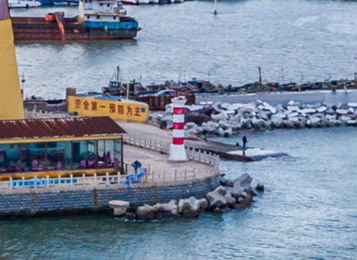
Date unknown. Active; focal plane 12 m (39 ft); three white flashes every 6 s. Approx. 9 m (30 ft) round fiberglass tower colored with red and white horizontal bands. Lu Yanfeng has a drone view (a portion is seen at right) and Google has a distant satellite view. Located on the wharf near the base of the ferry pier at Xīngchéng. Site open, tower closed. CN-1250.5; Admiralty P3965.36.

Gǔnzhuāngmǎtóu Light, Xīngchéng, September 2020
Google Maps drone view by Lu Yanfeng
Xīngchéng Kèyùnmǎtóu (Passenger Pier)
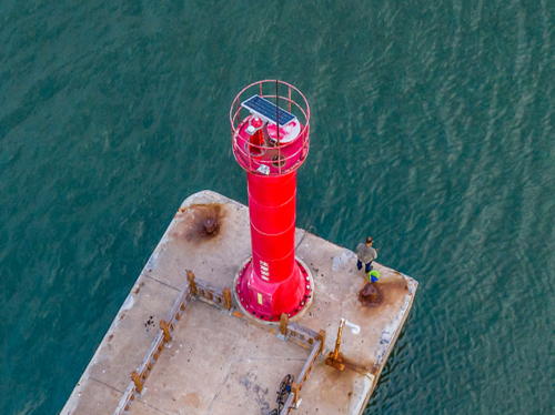
Date unknown. Active; focal plane 12 m (39 ft); red flash every 2 s. Approx. 9 m (30 ft) round red fiberglass tower. Lu Yanfeng has a drone view (a rotated version is at right) and Google has an indistinct satellite view. Located at the end of the ferry pier at Xīngchéng. Site status unknown (may be accessible by walking the pier). CN-1250.52; Admiralty P3965.35.
Júhuādǎo (Chrysanthemum Island) North
Date unknown. Active; focal plane 38 m (125 ft); two white flashes every 6 s. 18 m (59 ft) white concrete tower. No photo available and the tower is not seen in Bing's satellite view. Júhuādǎo is a substantial island off the coast about 40 km (25 mi) south of Húludǎo. Located on heights at the northern tip of the island. Site status unknown. CN-1250.1; Admiralty P3965.1.
Júhuādǎo (Chrysanthemum Island)
Date unknown. Active; focal plane 69 m (226 ft); white flash every 4 s. 7 m (23 ft) white concrete tower. No photo available but Bing has an indistinct satellite view. Located on a hillside at the southeast corner of the island. Site status unknown. CN-1251; Admiralty P3965.
Táizilǐ
Date unknown. Active; focal plane 35 m (115 ft) (?); red flash every 4 s. 18 m (59 ft) concrete tower. No photo available; the light appears to be just offshore in Bing's satellite view, in which case the listed focal plane is incorrect. Located at a headland at Bīnhǎi in southern Xīngchéng. Site status unknown. CN-1251.04; Admiralty P3964.6.
Niángniángdǐng (Empress Head)
Date unknown. Active; focal plane 30 m (98 ft); one long white flash every 10 s. 18 m (59 ft) concrete tower. No photo available but Google has a satellite view. Located at a headland at Bīnhǎi about 10 km (6 mi) southwest of the Táizilǐ light. Site status unknown. CN-1251.06; Admiralty P3964.4.

Kèyùnmǎtóu Light, Xīngchéng, September 2020
Google Maps drone view by Lu Yanfeng

Suízhōng County Lighthouses
** Dāolóngzuǐ (Tuánshānzi, Tuan Shan Chiao, Daolong Zui) (2)
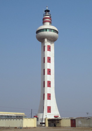
1998. Active; focal plane 41 m (135 ft); three white flashes, in a 2+1 pattern, every 20 s. 39 m (128 ft) round cylindrical concrete tower with three buttresses, a large round observation room near the top, and lantern and gallery. The lighthouse is white concrete with red trim. A photo is at the top of this page, a good closeup photo is available, and Google has a satellite view. Located at Tuánshānzi, about 13 km (8 mi) southeast of Suízhōng on the west side of Liáodōng Bay. Site open; the observation level of the tower is probably open, but no information is available on this. CN-1251.12; Admiralty P3964; NGA 18387.
Suízhōng Gǎng Main Range Front
Date unknown. Active; focal plane 42 m (138 ft); continuous white light. Approx. 38 m (125 ft) square concrete tower painted with red and white horizontal bands. No photo available but Google has a satellite view. Located on the quay of a new harbor about 40 km (25 mi) east of Shānhǎiguān. Site status unknown. CN serial 1610661.01; Admiralty P3960.43.
Suízhōng Gǎng Main Range Rear
Date unknown. Active; focal plane 62 m (203 ft); continuous white light. Approx. 57 m (187 ft) square concrete tower painted with red and white horizontal bands. No photo available but Google has a satellite view. Located about 1 km (0.6 mi) northwest of the front light, on the same quay. Site status unknown. CN serial 1610661.02; Admiralty P3960.44.
Suízhōng Pier 36 Range Front
Date unknown. Active; focal plane 30.5 m (100 ft); continuous light, white or red depending on direction. 33 m (108 ft) tapered round concrete tower carrying a triangular lantern structure. Tower is white with a red vertical stripe. No photo available but Google has a satellite view. Located at the waterfront of the Pier 36 basin, about 6 km (3.5 mi) west of the main quay. Site and tower closed. CN-1251.43; Admiralty P3960.28.
Suízhōng Pier 36 Range Rear
Date unknown. Active; focal plane 47 m (154 ft); continuous light, white or red depending on direction. 37 m (121 ft) tapered round concrete tower carrying a square lantern structure. Tower is white with a red vertical stripe. No photo available but Google has a satellite view. Located about 650 m (0.4 mi) north of the front light. Site status unknown. CN-1251.44; Admiralty P3960.281.
Suízhōng Gǎng West Range Front (3 towers)
Date unknown. Active; focal plane 17 m (56 ft); continuous white light. 16 m (52 ft) square pyramidal skeletal towers. No photo available but Google has a satellite view showing the three towers. Located at the water's edge of a harbor basin on the east side of Suízhōng. Site status unknown. CN-1251.455, Admiralty P3960.36 (middle tower); CN-1251.465, P3960.37 (east tower); and CN-1251.48, P3960.38 (west tower).
Suízhōng Gǎng West Range Rear (3 towers)
Date unknown. Active; focal plane 19 m (59 ft); continuous white light. 18 m (56 ft) square skeletal tower. No photo available but Google has a satellite view of the three towers (the west tower is obscured by buildings). Located about 100 m (330 ft) north of the front light. Site status unknown. CN-1251.46, Admiralty P3960.361 (middle tower); CN-1251.47, P3960.371 (east tower); and CN-1251.475, P3960.381 (west tower).
 
* Huánhǎisì (Huánhǎisìdìzuǐ) (2)
1997 (station established 1988). Active; focal plane 25 m (82 ft); white flash every 10 s. 12 m (39 ft) concrete tower: a round inverted conical lantern structure is supported by three columns. The entire lighthouse is white. The light is near the base of a much taller square tower topped by a radar dome. An MSA photo is at right and Google has a satellite view. Located on a promontory about 10 km (6 mi) east of Shānhǎiguān, near the border with Héběi province. Accessible by road. Site open, tower closed. CN-1251.54; Admiralty P3960; NGA 18390.

Huánhǎisì Light, Suízhōng County
PRC Maritime Safety Administration photo

Information available on lost lighthouses:

Notable faux lighthouses:

Adjoining pages: East: Southwestern Liáoníng | Southwest: Qinshandao

Return to the Lighthouse Directory index | Ratings key

Posted February 25, 2008. Checked and revised July 20, 2023. Lighthouses: 40; lightships: 1. Site copyright 2023 Russ Rowlett and the University of North Carolina at Chapel Hill.