Lighthouses of China: Southwestern Liáoníng

The People's Republic of China (中华, Zhōnghuá in Chinese), has a lengthy coastline, many large harbors, and a large number of lighthouses. During the colonial period of the late 19th and early 20th centuries Western powers occupied a number of locations in China and built lighthouses, many of which survive. In more recent years the People's Republic has developed modern ports throughout the country and built many lighthouses to serve them.

China is divided into 23 provinces and 11 other province-level regions of various special types. Liáoníng Province is in northeastern China at the northern end of the Chinese coast. A principal geographical feature of the province is the Liáodōng (Liaotung) Peninsula, which projects into the northern end of the Yellow Sea, separating Korea Bay on the east from Liáodōng Bay on the west. The major port complex of Dàlián is near the end of the peninsula on the eastern side.

During the colonial period Russia and Japan vied for control of this strategically located area. In 1898 Russia leased the Dàlián area from China, but Japan conquered the Russian colony during the Russo-Japanese War of 1904-05. In 1931 Japan invaded northeast China and incorporated Liáoníng (then called Fengtian) into the puppet state of Manchukuo until the end of the Second World War in 1945. Soviet troops then occupied Dàlián; the city was returned to Chinese sovereignty in 1950 but Soviet troops remained until they were withdrawn in 1955. The city was called Darien in English and Japanese (大連) and Dalniy (Дальний) in Russian.

Liáoníng is divided into 14 regions, 12 classified as prefectural-level cities (dìjíshì) and 2 as sub-provincial-level cities (fùshĕngjí). The regions are subdivided into districts classified at various administrative levels. This page includes lighthouses on the east coast of Liáodōng Bay in the Jīnzhōu and Wǎfángdiàn districts of the sub-provincial-level city of Dàlián and in the prefectural-level city of Yíngkǒu.

Lighthouses in China are maintained by the PRC Maritime Safety Administration. The administration is organized in regional administrations; Liáoníng lighthouses fall under the Liáoníng MSA, a branch office of the Tianjin MSA.

There are many languages and dialects spoken in China, but Standard Chinese, often called Mandarin, is official. The pīnyīn system for transliterating Chinese into Latin characters is now the international standard but some locations continue to be known also under the spellings of older transliteration systems. The Chinese word for a lighthouse is dēngtǎ (灯塔). In Standard Chinese jiāo (formerly chiao) is a reef or rock, jiǎo is a cape or headland, dǎo (tao) is an island; (tsu) or tuózi ("lump") is a small island, hǎi is a sea, wān is a bay, hǎixiá is a strait, or jiāng is a river, hékǒu ("river mouth") is an estuary, and gǎng (kang) is a harbor.

ARLHS numbers are from the ARLHS World List of Lights. CN numbers are Chinese light list numbers. Admiralty numbers are from volume P of the Admiralty List of Lights & Fog Signals. U.S. NGA List numbers are from Publication 112.

General Sources
Online List of Lights - China
Photos by various photographers posted by Alexander Trabas.
Chinese English Pinyin Dictionary
A useful tool for juggling the representations of Chinese names.
Leuchttürme Chinas auf historischen Postkarten
Historic postcard views posted by Klaus Huelse.
Navionics Charts
Navigation chart for Liáoníng.


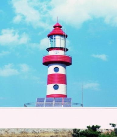
Dàgūshān Light, Wǎfángdiàn, 2013
unattributed photo, probably by PRC Maritime Safety Administration
Dàlián Subprovince Lighthouses

Jīnzhōu District West Coast (Pǔlándiàn Harbor) Lighthouses
Pǔlándiàn harbor is a ria (drowned valley) that extends through the Jīnzhōu District to the Pǔlándiàn District. Lighthouses on the east coast of the Jīnzhōu District are described on the Southeastern Liáoníng page. This Jīnzhōu (金州) is easily confused with the city of Jīnzhōu (锦州) on the west side of Liáodōng Bay. Lighthouses of that city are listed on the Western Liáoníng page.

Kōngtuózi (Pǔlándiàn Outbound Range Rear)
Date unknown. Active; focal plane 62 m (203 ft); red light, 3 s on, 3 s off. 10 m (33 ft) skeletal tower carrying a large daymark. No photo available but Google has an indistinct satellite view. This range guides ships leaving Pǔlándiàn. Located on a small but high island off the southern entrance to Pǔlándiàn harbor. Accessible only by boat. Site and tower closed. CN-1188; Admiralty P3983.71.
Pǔlándiàn Outbound Range Front
Date unknown. Active; focal plane 39 m (128 ft); continuous red light. 8.5 m (28 ft) tower carrying a large daymark. No photo available but Google has an indistinct satellite view. Located on a farm on the promontory of Hòutánzuǐ at the south side of the southern entrance to Pǔlándiàn harbor. Site and tower closed. CN-1187; Admiralty P3983.7.

Wǎfángdiàn City Lighthouses
The county-level city of Wǎfángdiàn has about 1 million inhabitants and is famous in China for growing apples and manufacturing ball bearings.

Chángxīngdǎo (Húlúshān Wān) South Breakwater
2009. Active; focal plane 17 m (56 ft); green light, 3 s on, 3 s off. 12 m (39 ft) round cylindrical white concrete tower. No photo available but Google has a satellite view. Located at the end of the south outer breakwater of the Húlúshān Bay harbor of Wǎfángdiàn. Site status unknown. Admiralty P3983.15.
Chángxīngdǎo (Húlúshān Wān) West Breakwater
2009. Active; focal plane 17 m (56 ft); red light, 3 s on, 3 s off. 12 m (39 ft) round cylindrical white concrete tower. No photo available but Google has a satellite view. Located at the end of the north outer breakwater of the Húlúshān Bay harbor of Wǎfángdiàn. Site status unknown. Admiralty P3983.1.
Chángxīngdǎo (Húlúshān Wān) North Breakwater
Date unknown. Active; focal plane 17 m (56 ft); red light, 3 s on, 3 s off. Approx. 12 m (39 ft) round cylindrical white concrete tower with lantern and gallery. No photo available but Google has a fuzzy satellite view. Located at the end of the inner breakwater of the Húlúshān Bay harbor of Wǎfángdiàn. Site status unknown. CN-1198.8; Admiralty P3983.2.
 
Changxingdao Light
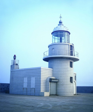
Chángxīngdǎo Light, Wǎfángdiàn
PRC Maritime Safety Administration photo
Chángxīngdǎo (1)
1932. Reactivated (inactive 1945-1960 and probably inactive again). Listed as active; focal plane 199 m (653 ft); white flash every 25 s. 10 m (33 ft) round cylindrical concrete tower with lantern and gallery, attached to a 1-story concrete equipment building. Entire lighthouse covered with white tiles. An MSA photo is above right. Google's satellite view shows a tall tower next to the lighthouse, possibly a new lighthouse but the Admiralty has issued no revisions to its listing. The lighthouse was heavily damaged in 1945, near the end of World War II, and it remained out of service until restored by the Navy in 1960. Chángxīngdǎo is a large island, about 25 km (15 mi) long, separated from the west coast of the Liáodōng Peninsula by a narrow channel. Located on a high bluff at the west end of the island. Site status unknown. ARLHS PRC-013; CN-1199; Admiralty P3983; NGA 18334.
Chángxīngdǎo North Harbor West Breakwater
2013. Active; focal plane 21 m (69 ft); continuous green light. 15 m (49 ft) round concrete tower painted with green and white horizontal bands. No photo available but Google has a satellite view. Located on the west (really south) breakwater of Wǎfángdiàn's new north harbor. Site status unknown. CN-1199.0023; Admiralty P3982.7.
Chángxīngdǎo North Harbor East Breakwater
2013. Active; focal plane 21 m (69 ft); continuous red light. 15 m (49 ft) round concrete tower painted with red and white horizontal bands. No photo available but Google has a satellite view. Located on the east (really north) breakwater of Wǎfángdiàn's new north harbor. Site status unknown. CN-1199.0022; Admiralty P3982.6; NGA 18334.1.
* Dàgūshān
1992. Active; focal plane 79 m (259 ft); white flash every 20 s. 19.5 m (64 ft) round concrete tower with lantern and gallery, painted with red and white horizontal bands. A photo is at the top of this page and Google has a satellite view. Located on a sharp promontory of the Liáodōng Peninsula mainland about 16 km (10 mi) northwest of Fúzhōuchéng. Accessible by road, according to MSA. Site probably open, tower closed. ARLHS PRC-020; CN-1199.02; Admiralty P3982; NGA 18334.3.
* Tàipíngjiǎo (Huátóng)
Date unknown. Active; focal plane 35 m (115 ft); white flash every 15 s. 13 m (43 ft) round cylindrical concrete tower with gallery, covered with white tiles. An MSA photo is at right and Google has a satellite view of the station. Located on a promontory sheltering the north side of the harbor of Huátóng. Accessible by road, according to MSA. Site probably open, tower closed. ARLHS PRC-059; CN-1199.03; Admiralty P3981; NGA 18334.6.

Tàipíngjiǎo Light, Wǎfángdiàn
PRC Maritime Safety Administration photo

Yíngkǒu Prefecture Lighthouses

The prefectural-level city of Yíngkǒu is a major seaport at the northeastern corner of the Bóhǎi Gulf and the mouth of the Liáo River, the largest river of Liáoníng province. The prefecture has a total population of about 2.5 million; the urban portion of the city has a population of about 900,000. Yíngkǒu is divided into six districts.

Bàyúquān District Lighthouses
Bàyúquān is a historic port on the south side of Yíngkǒu. Known for its exports of seafood (bàyú is a species of mackeral), the port has been expanded to handle bulk carriers and containerships.

Xiānréndǎo South Breakwater
Date unknown. Active; focal plane 17 m (56 ft); green light, 4 s on, 2 s off. 14 m (46 ft) round concrete tower, painted with green and white horizontal bands. No photo available but Google has a satellite view. Located on the south breakwater of the Xiānréndǎo harbor on the south side of Bàyúquān. Site status unknown. CN-1199.044; Admiralty P3979.45; NGA 18334.62.
Xiānréndǎo North Breakwater
Date unknown. Active; focal plane 14 m (46 ft); red light, 4 s on, 2 s off. 12 m (39 ft) round concrete tower, painted with red and white horizontal bands. No photo available but Google has a satellite view. Located on the north breakwater of the Xiānréndǎo harbor. Site status unknown. CN-1199.0441; Admiralty P3979.44; NGA 18334.61.
Xiānréndǎo Range Front
2018. Active; focal plane 40 m (131 ft); continuous white light. 34 m (112 ft) square cylindrical skeletal tower painted with red and white horizontal bands and carrying a black triangular daymark. No photo available but Google has a satellite view. This is both an approach and entrance range for Xiānréndǎo. Located on a platform in the harbor of Xiānréndǎo. Accessible only by boat. Site and tower closed. Admiralty P3980.2.
Xiānréndǎo Range Rear
2018. Active; focal plane 65 m (213 ft); continuous white light. 59 m (194 ft) square cylindrical skeletal tower painted with red and white horizontal bands and carrying a black triangular daymark. No photo available but Google has a satellite view. Located on a spur of the north breakwater at Xiānréndǎo. Site and tower closed. Admiralty P3980.21.
Bàyúquān Outer Breakwater South Pier
Date unknown. Active; focal plane 14 m (46 ft); green light, pattern unknown. 12 m (39 ft) round concrete tower painted with green and white horizontal bands. No photo available but Google has a satellite view. Located on an outer breakwater at Bàyúquān. Site status unknown. CN serial 1410190.361; Admiralty P3979.198.
Bàyúquān West Breakwater South End (2?)
Date unknown. Active; focal plane 12 m (39 ft); two white flashes every 5 s. 10 m (33 ft) round cylindrical concrete tower with lantern and gallery. No photo available but Google has a satellite view. Located at an elbow of the main breakwater at Bàyúquān (this was originally the south end of a detached breakwater). Site status unknown. CN-1199.098; Admiralty P3979.25.
Bàyúquān West Breakwater North End (2?)
Date unknown. Active; focal plane 9.5 m (31 ft); quick-flashing red light. 8 m (26 ft) round cylindrical concrete tower with lantern and gallery. No photo available and Google's satellite view appears to show a smaller light. NGA lists the focal plane height as 9 m (30 ft) and describes the lighthouse as green; the MSA Shanghai light list describes the lighthouse as white. Located at the north end of the main breakwater at Bàyúquān. Site status unknown. CN-1199.2; Admiralty P3979.2; NGA 18334.8.
Bàyúquān Approach Range Front (3 towers?)
Date unknown. Active; focal plane 21 m (69 ft); continuous light, white on the center tower, red on the left tower and green on the right tower. 25 m (82 ft) square towers, painted with orange and white horizontal bands and carrying a triangular orange daymark. No photo available. Google has a satellite view of the center front light on the end of a quay opposite the entrance to the harbor but a second satellite view fails to show the two closely-spaced right and left front lights about 800 m (1/2 mi) to the east. Site and tower closed. CN-1199.1, Admiralty P3979, NGA 18334.7 (center); CN-1199.14; Admiralty P3979.102 (left); CN-1199.12; Admiralty P3979.104 (right).
Bàyúquān Approach Range Rear (3 towers?)
Date unknown. Active; focal plane 45 m (148 ft); continuous light, white on the center tower, red on the left tower and green on the right tower. 48 m (157 ft) square towers, painted with orange and white horizontal bands and carrying a triangular orange daymark. No photo available but Google has a satellite view of the centre rear light in the harbor area 1.74 km (1.1 mi) east of the front light. The right and left rear lights are hard to find in a satellite view of a crowded area to the east. Site and tower closed. CN-1199.11, Admiralty P3979.1, NGA 18334.71 (center); CN-1199.15; Admiralty P3979.103 (left); CN-1199.16; Admiralty P3979.105 (right).
Bàyúquān Bulk Cargo Pier (2?)
Date unknown. Active; focal plane 12 m (39 ft); quick-flashing green light. 12 m (39 ft) round cylindrical concrete tower with lantern and gallery, painted with green and white horizontal bands. Biswajit Shaw's photo is at right and Google has a satellite view. NGA lists the focal plane height as 9 m (30 ft) and describes the lighthouse as white; an older MSA Shanghai light list also described the lighthouse as white. Located on an extension of the north breakwater at Bàyúquān. Site status unknown. CN-1199.55; Admiralty P3979.16.
Bàyúquān Outer Breakwater North Pier
Date unknown. Active; focal plane 14 m (46 ft); red light, 2 s on, 4 s off. 12 m (39 ft) round concrete tower painted with red and white horizontal bands. No photo available but Google has a satellite view. Located on an outer breakwater at Bàyúquān. Site status unknown. CN-1199.715; Admiralty P3979.196.

Bulk Cargo Pier Light, Bàyúquān, March 2023
Google Maps photo by Biswajit Shaw
Bàyúquān Branch Channel Range Front
Date unknown. Active; focal plane 30 m (98 ft); continuous white light. 29 m (95 ft) square skeletal tower. No photo available but Google has a satellite view. This is an entrance range for the harbor. Located on the quay north of the north breakwater. Site status unknown. CN-1199.7; Admiralty P3978.9.
Bàyúquān Branch Channel Range Rear
Date unknown. Active; focal plane 35.5 m (116 ft); continuous white light. 34.5 m (113 ft) square skeletal tower. No photo available but Google has a satellite view. Located on the quay north of the north breakwater about 250 m (800 ft) northeast of the front light. Site status unknown. CN-1199.71; Admiralty P3978.91.
* Táizishān (2)
1993 (station establishment date unknown). Active; focal plane 131 m (430 ft); white flash every 10 s. 21 m (69 ft) round cylindrical concrete tower with lantern, gallery, and four ribs. Tower covered with white tiles; lantern and gallery painted white. A photo is at right, another photo (third photo on the page) is available, and Google has a satellite view. The lighthouse was built in 1989 but not activated until 1993. An older lighthouse is seen in the background of an MSA photo, but it has been removed. Táizishān means "table mountain." Located in a public park on a hill above the harbor of the new port of Bàyúquān, about 13 km (8 mi) north of Xiongyuecheng. Site open, tower closed. CN-1199.8; Admiralty P3978; NGA 18335.
Bàyúquān Steel Area Range Front (3 towers)
Date unknown. Active; focal plane 31.5 m (103 ft); continuous light, white on the center tower, red on the left tower and green on the right tower. 34 m (112 ft) square cylindrical skeletal towers. No photo available but Google's satellite view shows the three towers. Located in the Steel Area harbor facilities on the north side of Bàyúquān. Site and tower closed. CN-1199.812, Admiralty P3977.81 (center); CN-1199.814, P3977.812 (right); and CN-1199.81, P3977.814 (left).
Bàyúquān Steel Area Range Rear (3 towers)
Date unknown. Active; focal plane 53 m (174 ft); continuous light, white on the center tower, red on the left tower and green on the right tower. 15 m (49 ft) square cylindrical skeletal towers. No photo available but Google's satellite view shows the three towers. Located about 1.5 km (1 mi) southeast of the front lights. Site and tower closed. CN-1199.813, Admiralty P3977.811 (center); CN-1199.815, P3977.813 (right); and CN-1199.811, P3977.815 (left).

Táizishān Light, Bàyúquān
unattributed photo posted by Túniú travel agency

Xīshì District Lighthouses
This district is on the east side of the mouth of the Liáo River. The lights in this group lead vessels to the traditional docks along the river; the more modern harbor is to the west of the river in the Dàwā District of Pánjǐn (see the Western Liáoníng page).
Lightfloat Yíngkǒu (3?)
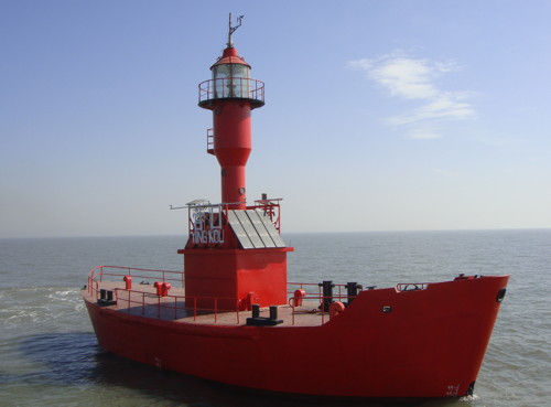
2015 (station established 1867). Inactive as a lightship since 2015. This was a 23 m (75 ft) steel lightship; light tower with lantern and gallery amidships. Entire vessel painted red. A photo is at right. The lightship deployed in 1917 was crewed until it was converted to automatic operation in 1985. It was replaced in 2015 by a new automated lightfloat including an automatic weather station and a racon (radar reflector). The older Yíngkǒu lightship arrived in Shanghai where it was restored for display at the China Maritime Museum. Located about 12 km (7.5 mi) southwest of the mouth of the river Liáo and the harbor of Yíngkǒu. Accessible only by boat. Site open, vessel closed. ex-CN-1200; ex-Admiralty P3970. Racon: NGA 18336.
Yíngkǒu Bar Range Front
Date unknown. Active; focal plane 17.5 m (57 ft); continuous white light. 22 m (72 ft) square skeletal tower, painted black, carrying a triangular daymark. No photo available but Google has a satellite view. This is the first of a series of ranges guiding ships on the difficult approach to Yíngkǒu through increasingly shallow water at the head of the Bóhǎi Gulf. Located on the coast at the edge of an extensive saltworks on the southwest side of the city. Site status unknown. CN-1202; Admiralty P3971; NGA 18340.
Yíngkǒu Bar Range Rear
Date unknown. Active; focal plane 32 m (105 ft); continuous white light. 32.5 m (106 ft) square skeletal tower, painted black, carrying a triangular daymark. No photo available and the black lighthouse is hard to see in Google's satellite view. Located in the salt pans, 950 m (0.6 mi) northeast of the front light. Site status unknown. CN-1203; Admiralty P3971.1; NGA 18344.
Lightship Yingkou
Lightship Yíngkǒu, April 2013
photo posted by Yíngkǒu Meteorological Bureau
Yíngkǒu Turning Beacon
Date unknown. Active; focal plane 16 m (52 ft); continuous white light. 19 m (69 ft) square skeletal tower, painted black, carrying a ball-shaped daymark. No photo available but Google has a satellite view. Located offshore about 400 m (1/4 mi) northwest of the Yíngkǒu Bar Range Front Light. Accessible only by boat. Site status unknown. CN-1212.1; Admiralty P3970.5; NGA 18338.
Yíngkǒu Inner Channel Entrance Range Front
Date unknown. Active; focal plane 14 m (46 ft); continuous red light. 18 m (59 ft) square skeletal tower, painted black, carrying a triangular daymark. No photo available but Google has a satellite view. Located on the east side of the entrance to the Liáo River. Site status unknown. CN-1209; Admiralty P3971.9; NGA 18348.
Yíngkǒu Inner Channel Common Range Rear
Date unknown. Active; focal plane 29 m (92 ft); continuous red light. 29 m (92 ft) square skeletal tower, painted black, carrying a triangular daymark. No photo available and the light is hard to find in Google's satellite view. Located about 1 km (0.6 mi) northeast of the Entrance Range Front light. Site status unknown. CN-1210; Admiralty P3972; NGA 18352.
Yíngkǒu No. 4 Range Front
Date unknown. Active; focal plane 20 m (66 ft); continuous red light. 20 m (66 ft) square skeletal tower, painted black, carrying a triangular daymark. No photo available and the black lighthouse is hard to see in Google's satellite view. This light and the Common Range Rear light provide a range for vessels leaving Yíngkǒu. Located on the east bank of the Liáo River about 600 m (0.38 mi) north of the Common Rear light. Site status unknown. CN-1210.1; Admiralty P3972.1; NGA 18353.
Paotai Turning
Date unknown. Active; focal plane about 17 m (56 ft); quick-flashing green light. Approx. 15 m (49 ft) square skeletal tower. No photo available but Google has a satellite view. Located near office buildings on the east bank of the river. Site status unknown. CN-1220.1; Admiralty P3972.15; NGA 18355.
Yíngkǒu Shipyard Range Rear
Date unknown. Active; focal plane 14 m (46 ft); continuous red light. 12 m (39 ft) square skeletal tower. No photo available but Google has a satellite view. The front light is on an 8 m (26 ft) square skeletal tower. Located in downtown Yíngkǒu. Site status unknown. CN-1227; Admiralty P3977.51.

Information available on lost lighthouses:

Notable faux lighthouses:

Adjoining pages: East: Southeastern Liáoníng | West: Western Liáoníng

Return to the Lighthouse Directory index | Ratings key

Posted February 25, 2008. Checked and revised July !3, 2023. Lighthouses: 42; lightships: 1. Site copyright 2023 Russ Rowlett and the University of North Carolina at Chapel Hill.