Lighthouses of China: Yāntái Area (Northern Shāndōng)

The People's Republic of China (中华, Zhōnghuá in Chinese) has a lengthy coastline, many large harbors, and a large number of lighthouses. During the colonial period of the late 19th and early 20th centuries Western powers occupied a number of locations in China and built lighthouses, many of which survive. In more recent years the People's Republic has developed modern ports throughout the country and built many lighthouses to serve them.

The country is divided into 23 provinces and 11 other province-level regions of various special types. Shāndōng (formerly spelled Shantung) is a province of northern China lying directly across the Yellow Sea (Huáng Hǎi) from South Korea. The province includes the Shāndōng Peninsula (Shāndōng Bandǎo), which separates the Yellow Sea from the Bohai Sea (Bó Hǎi). As a result the province has long coastlines facing north on the Bohai Sea and southeast on the Yellow Sea.

Shāndōng is divided into sixteen prefectural-level cities. All the lighthouses on this page are in the prefectural-level city of Yāntái. The prefecture is quite large. It includes the county-level cities of Láizhōu, Zhāoyuǎn and Lóngkǒu facing northwest on Láizhōu Bay; lighthouses of that coast are described on the Northwestern Shāndōng page. It also includes the county-level city of Hǎiyáng facing south on the Yellow Sea; lighthouses of that coast are described on the Wēihǎi Area page. This page covers the five urban and suburban districts of greater Yāntái facing northeast on the Bohai Sea.

Because of its strategic location and fine ports, the Shāndōng Peninsula was a target for foreign penetration during the colonial period. Opened to foreign trade in 1861, Yāntái was called "Chefoo" during the colonial period; Zhīfú is actually the name of a district in the city and an island nearby. The name Yāntái means "smoking platform" and refers to watchtowers maintained here in the Ming Dynasty to warn of approaching Japanese pirates.

There are many languages and dialects spoken in China, but Standard Chinese, often called Mandarin, is official. The pīnyīn system for transliterating Chinese into Latin characters is now the international standard but some locations continue to be known also under the spellings of older transliteration systems. The Chinese word for a lighthouse is dēngtǎ (灯塔). In Standard Chinese jiāo (formerly chiao) is a reef or rock, jiǎo is a cape or headland, dǎo (tao) is an island; (tsu) or tuózi ("lump") is a small island, hǎi is a sea, wān is a bay, hǎixiá is a strait, or jiāng is a river, hékǒu ("river mouth") is an estuary, and gǎng (kang) is a harbor.

Lighthouses in China are maintained by the PRC Maritime Safety Administration. The administration is organized in four regional administrations; Shāndōng lighthouses fall under the Tiānjīn MSA and its district office at Yāntái.

ARLHS numbers are from the ARLHS World List of Lights. CN numbers are Chinese light list numbers. Admiralty numbers are from volume P of the Admiralty List of Lights & Fog Signals. U.S. NGA List numbers are from Publication 112.

General Sources
Online List of Lights - China
Photos by various photographers posted by Alexander Trabas.
World of Lighthouses - China
Photos by various photographers available from Lightphotos.net.
Chinese English Pinyin Dictionary
A useful tool for juggling the representations of Chinese names.
Leuchttürme Chinas auf historischen Postkarten
Historic postcard images posted by Klaus Huelse.
Navionics Charts
Navigation chart for Shāndōng.


Hòujīdǎo Light, Chángdǎo
PRC Maritime Safety Administration photo
Pénglái District Lighthouses

In 2020 the county-level city of Pénglái and the county of Chángdǎo (the Chángshān Islands) were merged to form a single district of Yāntái.

Pénglái City Lighthouses
Pénglái is a historic fortified city facing the Bohai Gulf; it has a population of about 450,000.

*
Luánjiākǒu (2)
Mid 1950s. Probably inactive but listed by the Admiralty with focal plane 17 m (56 ft); white flash every 4 s. Approx. 10 m (33 ft) round brick tower. kknews.cc has a closeup photo (#5 on the page) and Google has a satellite view. According the kknews article the original lighthouse was similar but was destroyed during World War II; the present lighthouse was "abandoned" in the 1990s. (This seems likely because the light would have very little navigational value today.) Located behind the port area at Luánjiākǒu, an industrial harbor on the southwest side of Pénglái. Site open, tower closed. CN-1455; Admiralty P3895.88.
*** Lǎoběishān (4) (Old North Mountain) (Péngláitóu, Pénglái Head)
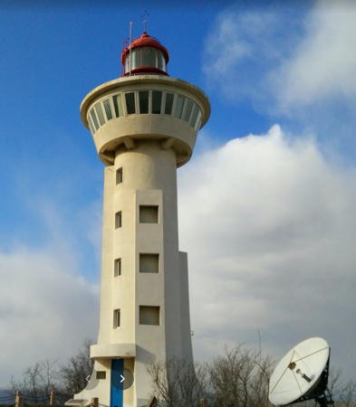
2000 (station established 1941). Active; focal plane 90 m (295 ft); white flash every 5 s. Approx. 27 m (89 ft) round cylindrical concrete tower with lantern, gallery, and a large round observation room. Tower painted white, lantern red. Zhao Zhilong has the closeup photo seen at right, Steven Du has a 2014 photo, C.P. Wang has a 2010 photo, Xiè Xiǎo Zhèng has a view from the sea, and Google has a satellite view. The 1972 lighthouse was a 10 m (33 ft) round concrete tower with lantern and gallery; it replaced a skeletal tower installed in 1952. Cable cars transport visitors from the city to a point within walking distance of the lighthouse. Located on heights above the east side of the harbor of Pénglái. Site open, observation room open. CN-1456; Admiralty P3895.85; NGA 18558.
* Pénglái Gé (Puzhao Pagoda)
1868 (the tower may be older). Inactive, but decorative lights are displayed, at least for special occasions. Approx. 14 m (46 ft) hexagonal cylindrical brick tower topped by a pagoda supported by six columns. Robert Ou has a photo, Eric Niu has a photo, Zhao Zhilong has a closeup, and Bing has a satellite view. Probably built as a watchtower, this historic building is part of the Pénglái fortress, which dates to the 11th century. Below the fortress, Pénglái has a sheltered "secret" harbor that was a historic naval base; Google also has a satellite view of this area. The fortress was captured by Manchu forces in a famous battle in 1632. A light was is said to have been displayed from the tower from 1868 until the approach of World War II. However, to the best of our knowledge this light was never listed on international light lists. The tower was restored in 1958 and is a treasured architectural landmark. Located to the east of the Lǎoběishān lighthouse. Site open, tower closed.
Pénglái Dōnggǎng East Jetty
Date unknown. Active; focal plane about 15 m (49 ft); two green flashes every 6 s. Approx. 12 m (39 ft) green post mounted on a square 1-story pierhead building. No photo available but Google has a satellite view. Located on the east pier of Pénglái's East Harbor (Dōnggǎng) about 8 km (5 mi) east of the traditional harbor. Site and tower closed. CN-1482.56; Admiralty P3895.71.
Dì Jiǎo (2?)
Date unknown. Active; focal plane 45 m (148 ft); white flash every 8 s. Approx. 8 m (26 ft) round white tower. A photo is available and Google has a satellite view. The original light was a 5 m (17 ft) round white tower but the photo shows a newer and somewhat taller tower. Located on a headland about 13 km (8 mi) east of Pénglái. Site status unknown. CN-1483; Admiralty P3895.6.
Liújiāwàng
Date unknown. Active; focal plane 38 m (125 ft); two white flashes every 6 s. Approx. 15 m (49 ft) round stone or masonry tower. No photo available but Bing has a fuzzy satellite view. Located on a bluff north of Liújiāwàng, a port about 20 km (13 mi) east of Pénglái. Site status unknown. CN-1484; Admiralty P3891.4.

Lǎoběishān (Pénglái Gang) Light, Pénglái, December 2014
Google Maps photo by Zhao Zhiyang

Northern Chángshān Islands (Miàodǎo Islands) Lighthouses
The Chángshān Islands ("Long Mountain Islands") lie in a ragged chain across the entrance to the Bohai Gulf north of Pénglái, creating a serious hazard for shipping. They are also called the Miàodǎo (Temple) Islands because of the many Buddhist temples found on them. There are 32 islands in all, ten of them large enough to be inhabited; the total population is about 43,000. The islands are accessible by ferry from Pénglái and are popular resort destinations. After being closed to Western visitors for all of the Communist period the islands were opened to tourism in December 2008.

Běihuángchéngdǎo (3)
1980 (station established 1956). Active; focal plane 171 m (561 ft); two white flashes every 15 s. 10 m (33 ft) round concrete tower with lantern and gallery, covered with white tile; lantern painted red. A photo is at right, several other photos are available, and Google has a satellite view. The original lighthouse was a skeletal tower; it was replaced in 1974 by a 5 m (17 ft) concrete tower. This is probably the most important of the gulf island lighthouses. It stands at the northern tip of a small island nearly in the center of the entrance to the Bohai Gulf, about 55 km (35 mi) north of Pénglái and 50 km (30 mi) from the tip of the Liaodong Peninsula to the north. Site status unknown. CN-1482; Admiralty P3892.5; NGA 18568.
Xiānglújiāo
Date unknown. Active; focal plane 9 m (30 ft); red flash every 4 s. 8 m (26 ft) round concrete tower painted with red and white horizontal bands. No photo available but Google has a satellite view. Located at the tip of a reef north of Nánhuánghéng, marking the narrow passage between that island and Běihuángchéngdǎo. Site status unknown. CN-1480; Admiralty P3892.6.
Tuózidǎo
Date unknown. Active; focal plane 68 m (223 ft); three white flashes every 6 s. 8 m (26 ft) round white concrete tower. Lan Hong Zhong Tian has a distant view from the sea and Google has a distant satellite view. Located on a small island, attached by a causeway to the southern tip of the larger island of Tuózidǎo. Site status unknown. CN-1477; Admiralty P3893.7.
Hòujīdǎo (Howki Island, Monkey Island)
1882 (British). Active; focal plane 104 m (341 ft); white flash every 12 s. 14 m (46 ft) round stone tower with lantern and gallery, attached to one end of a 1-story stone keeper's house. Lighthouse painted black. An MSA photo is at the top of this page and Google has a satellite view of the station. This lighthouse was built by the British for the Chinese Maritime Customs Department. The lantern was destroyed during World War II and was replaced when the lighthouse was repaired in 1953. Hòujīdǎo (Rocky Island) is a small island about 30 km (19 mi) north northwest of Pénglái. A shipping channel through the islands passes between this light and the Beichangshan lighthouse (next entry). Located on the highest point of the island. Site status unknown. CN-1474; Admiralty P3892; NGA 18556.

Běihuángchéngdǎo Light, Chángdǎo, 2019
photo posted by A CAKE

Southern Changshan Islands (Miàodǎo Islands) Lighthouses
Běizhángshān (Běichángshān, Běizhángshāndǎo) (4)
Date unknown (station established 1951). Active; focal plane 102 m (335 ft); white flash every 10 s. Approx. 35 m (115 ft) round cylindrical concrete tower with lantern, gallery, and a large round observation room. Lighthouse painted white; lantern dome is red. A distant view is available and Bing has a satellite view. The original lighthouse was replaced in 1973; the present light is on a new location. The new light replaced a 12.5 m (41 ft) round cylindrical concrete tower with lantern and gallery, centered on a round 1-story concrete equipment building or keeper's house. Běizhángshāndǎo (North Long Mountain Island) is an inhabited island about 20 km (12.5 mi) north of Pénglái, off the north coast of the Shāndōng Peninsula; the island is connected by a bridge to Chángdǎo itself, the largest island in the chain. Located on the north coast of the island. Site status unknown; the lighthouse is accessible by road but may not be open to the public. CN-1473; Admiralty P3894; NGA 18536.
* Xīběizuǐ (Northwest Pass)
1986. Active; focal plane 27 m (88 ft); white flash every 4 s. 5 m (16 ft) round tower, painted white. Google has a satellite view and a street view from the beach. Located at the western end of Běizhángshāndǎo in what appears to be a park. Site open, tower closed. CN-1472; Admiralty P3894.5.
Chángdǎo Gǎng Kègǔn Pier
Date unknown. Active; focal plane 13 m (43 ft); quick-flashing red light. 8 m (26 ft) tower painted with red and white horizontal bands. No photo available but Google has an indistinct satellite view. Located on the ferry pier on the west side of Chángdǎo, the largest island of the archipelago, about 9 km (5.5 mi) north of Pénglái. Site status unknown. CN-1459.2; Admiralty P3895.2.
* Quèzuǐ (Quezuijianzi, Nánzhángshāndǎo) (2)
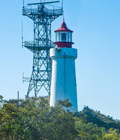
2010 (station establshment date unknown). Active; focal plane 75 m (246 ft); white flash every 10 s. 19 m (62 ft) round concrete tower with lantern and gallery. Lighthouse painted white, lantern red. The photo at right was taken as construction was completed, Chen Zhi has a distant view from the sea, and Google has a satellite view. The original light was at a much lower level. This new lighthouse was built in part as a tourist attraction and as a symbol for Chángdǎo. A tall Martyr's Monument has been built near the lighthouse. Located at the west point of Chángdǎo itself, Site status unknown. CN-1459; Admiralty P3895.22; NGA 18559.1.
Dǎliándǎo (Danglangdao)
1960. Active; focal plane 38 m (125 ft); three white flashes every 10 s. 5 m (16 ft) round tower, painted white. A view from the sea is available and Google has an indistinct satellite view. Located at the north end of a small island about 1.6 km (1 mi) west of the Xīběizuǐ light. Accessible only by boat. Site apparently open, tower closed. CN-1471; Admiralty P3895.38.

Quèzuǐ Light, Chángdǎo, November 2009
PRC Maritime Safety Administration photo
Lǚjiǎobàzǐ (2)
1976 (station established 1957). Active; focal plane 25 m (82 ft); white flash every 3 s. 5 m (16 ft) round tower, painted white. No photo available but Bing has a distant satellite view. Located on a reef off the northern tip of Xiǎohēishān, an island about 5 km (3 mi) west of the Běizhángshān light. Site status unknown. CN-1469; Admiralty P3895.35; NGA 18537.
Xiǎohēishān (Little Black Mountain)
1957. Active; focal plane 48 m (157 ft); red flash every 6 s. 5 m (16 ft) round tower with gallery, painted white. No photo available abut Bing has a distant satellite view. Listed by NGA as Miao Zui. Located at the southwestern end of Xiǎohēishān Island. Site status unknown. CN-1468; Admiralty P3895.3; NGA 18538.
Niútuózi (Cow Rock) (2)
1976 (station established 1948). Active; focal plane 32 m (105 ft); two white flashes every 6 s. 5 m (16 ft) round tower with gallery, painted white. No photo available but Google has a distant satellite view. Located near the southwestern end of an island about 4 km (2.5 mi) northwest of Chángdǎo. Site status unknown. CN-1466; Admiralty P3895.28; NGA 18539.

Eastern Changshan Islands (Miàodǎo Islands) Lighthouses
Xiǎozhúshāndǎo (Little Zhúshān Island)
1951. Active; focal plane 104 m (341 ft); white flash every 5 s. 5 m (16 ft) round rubblestone tower with gallery, painted white. No photo available but Google has a distant satellite view. Located atop a tiny island about 5 km (3 mi) west of the larger Dàzhúshāndǎo (next entry). Site status unknown. CN-1476; Admiralty P3893; NGA 18564.
Dàzhúshān (Dàzhúshāndǎo, Big Zhúshān Island)
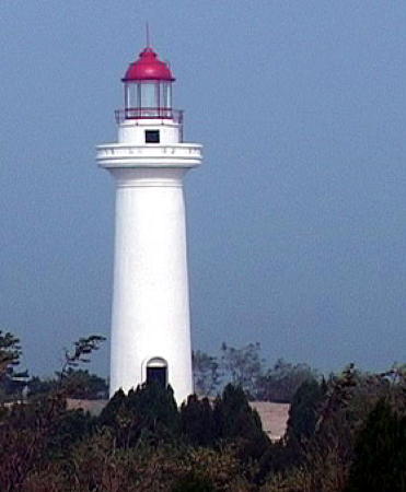
1980. Active; focal plane 204.5 m (671 ft); white flash every 8 s. 10 m (33 ft) round concrete or masonry tower with lantern and gallery, attached to a 1-story equipment building. Lighthouse painted with black and white horizontal bands. MSA's photo appears at right and Google has a distant satellite view. Located atop a small island about 30 km (19 mi) northeast of Pénglái. Site status unknown. CN-1475; Admiralty P3893.5; NGA 18560.

Dàzhúshāndǎo Light, Chángdǎo
PRC Maritime Safety Administration photo
Central Yāntái City Lighthouses

Fúshān District Lighthouses
Yāntái West Harbor Range Front
Date unknown. Active; focal plane 56 m (184 ft); continuous red light. 50 m (164 ft) square skeletal tower painted with red and white horizontal bands. No photo available but Google has a satellite view. This is the approach range for the city's industrial northwest harbor at Shānhòulǐjiā, on a headland about 30 km (19 mi) northwest of downtown Yāntái. Site status unknown. CN-1484.7; Admiralty P3891.03.
Yāntái West Harbor Range Rear
Date unknown. Active; focal plane 76 m (249 ft); continuous red light. 31 m (102 ft) square skeletal tower painted with red and white horizontal bands. No photo available but Google has an indistinct satellite view. Located 870 m (0.54 mi) south southwest of the front light. Site status unknown. CN-1484.8; Admiralty P3891.04.
Lóngdòngzuǐ
Date unknown. Active; focal plane 104 m (341 ft); white flash every 3 s. 10 m (33 ft) round stone tower with lantern and gallery. No photo available but Google has a satellite view. This is an important but very poorly known lighthouse. Located on the high promontory of Shānhòulǐjiā about 25 km (15 mi) northwest of Yāntái. Site status unknown. CN-1485; Admiralty P3891.
Bajiǎo
Date unknown. Active; focal plane 25 m (82 ft); three white flashes every 6 s. 9 m (30 ft) round stone tower. No photo available but Bing has a satellite view. Located on a promontory about 10 km (6 mi) south of Lóngdòngzuǐ. Site status unknown. CN-1486; Admiralty P3890.

Zhīfú District Lighthouses
Zhīfú ("Chefoo") is a rugged former island, now connected to the mainland by an isthmus of reclaimed land. Together with the island of Kōngtóng to the east it shelters the natural harbor of Yāntái. During the colonial period Westerners called the entire city Chefoo, but it was always Yāntái to its citizens.
Xiǎoshānzi (Little Rock Garden) (2)
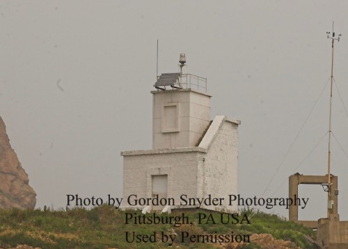
1967 (station established 1957). Active; focal plane 21 m (69 ft); white flash every 6 s. 8 m (26 ft) square cylindrical brick tower rising from a tiny 1-story square brick building. Lighthouse painted white. Gordon Snyder has contributed a photo (also seen at right) and Google has a satellite view. Located on a small island off Zhīfúdōngjiǎo (East Zhīfú Point), the east end of the Zhīfú peninsula sheltering the northwest side of Yāntái harbor. Accessible only by boat, although there should be a good view from the tip of the peninsula or from arriving ships. Site status unknown. CN-1488; Admiralty P3881; NGA 18588.
Běihǎi Pier (Salvage Pier)
Date unknown. Active; focal plane 10 m (33 ft); quick-flshing white light. 8 m (26 ft) tower painted with black and white horizontal bands. NGA describes a skeletal tower and Google's satellite view shows the tower mounted on a concrete base. Located at a pier in the north side of the north basin of Yāntái harbor. Site status unknown. Admiralty P3881.6; NGA 18587.8.
Service Boat Pier
Date unknown. Active; focal plane 13 m (43 ft); continuous green light. 8 m (26 ft) round metal tower. No photo available but Google has a satellite view. Located at a pier in the west side of the north basin of Yāntái harbor. Site status unknown. CN-1496.63; Admiralty P3881.5; NGA 18587.7.
Sìtū Breakwater
Date unknown. Active; focal plane 12 m (39 ft); quick-flashing green light. 8 m (26 ft) round metal tower. No photo available but Google has a satellite view. Located at a pier in the west side of the north basin of Yāntái harbor. Site status unknown. CN-1494.32; Admiralty P3881.8.
Sānqī Channel Range Front
Date unknown. Active; focal plane about 40 m (131 ft); continuous red light. Approx. 35 m (115 ft) slender round tower, painted with red and white horizontal bands. No photo available, but Google has a satellite view. This is an arrival range for a harbor in eastern Yāntái in the lee of the former Zhīfú Island (now a peninsula). Located on the waterfront of the harbor. Site status unknown. CN-1496.51; Admiralty P3881.9.

Xiǎoshānzi Light, Yāntái, June 2008
photo copyright Gordon Snyder Photography; used by permission
Sānqī Channel Range Rear
Date unknown. Active; focal plane about 50 m (164 ft); continuous red light. Approx. 45 m (148 ft) slender round tower, painted with red and white horizontal bands. No photo available, but Google has a satellite view. Located about 200 m (660 ft) west of the front light. Site status unknown. CN-1496.52; Admiralty P3881.91.
* Yāntái West Port Entrance Range Front (3 towers)
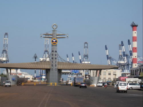
Date unknown. Active; focal plane 38 m (125 ft); continuous red light. 35 m (115 ft) slender round tower, painted with red and white horizontal bands. The tower also carries a diamond-shaped slatted daymark, painted black. This light is flanked by two 25 m (82 ft) skeletal towers that define the north and south edges of the entrance channel. A photo is at right and Google has a satellite view. Located at a street intersection just inside the entrance to the Yāntái harbor facilities. Site and tower closed, although one can see the tower from nearby major streets. CN-1508.19, Admiralty P3882.5, NGA 18587 (middle); CN-1508.21, P3883.1 (north); and CN-1508.22, P3883.5 (south).
* Yāntái West Port Entrance Range Rear (3 towers)
Date unknown. Active; focal plane 49 m (161 ft); continuous red light. 45 m (148 ft) slender round tower, painted with red and white horizontal bands. The tower also carries a diamond-shaped slatted daymark, painted black. This light is flanked by two 35 m (115 ft) towers that define the north and south edges of the entrance channel. No photo available but Google has a satellite view. Located in a neighborhood of apartments west of the Yāntái waterfront, 830 m (1/2 mi) west of the rear light; a plaza has been built around the lighthouse. Site open, tower closed. CN-1508.2, Admiralty P3882.51, NGA 18587.1 (middle), CN-1508.23, P3883.11 (north); and CN-1508.24, P3883.51 (south).
#Yāntái West Port Breakwater
Date unknown. Removed sometime after 2011. This was a 15 m (49 ft) square skeletal tower, painted red, mounted on a large 1-story concrete base. Lighthouse painted red. The light was present as recently as 2011 but the breakwater is now missing from Google's satellite view. Formerly located at the end of a breakwater extending north from the broad main quay of Yāntái harbor. Site status unknown. ex-CN-1502.1; ex-Admiralty P3886.5; ex-NGA 18587.5.

Yāntái West Port Entrance Range Front Light, Yāntái, August 2009
Google Maps photo by X L
Yāntái Inner Harbor Range Front
Date unknown. Inactive since 2023. 30 m (98 ft) square skeletal tower, painted with red and white horizontal bands. The top of the tower carries a triangular daymark, point up. Possibky removed; the tower is not conspicuous in Google's satellite view. Located on the east side of the broad main quay of Yāntái harbor. Site status unknown. CN-1505; ex-Admiralty P3887, NGA 18586.
Yāntái Inner Harbor Range Rear
Date unknown. Inactive since 2023. 39 m (128 ft) square skeletal tower, painted with red and white horizontal bands. The top of the tower carries a triangular daymark, point down. No photo available but Google has a satellite view. Located near the base of the broad main quay of Yāntái harbor. Site status unknown. CN-1506; ex-Admiralty P3887.1, NGA 18586.1.
Yāntái Detached Breakwater North End
Date unknown. Active; focal plane 16 m (52 ft); red flash every 4 s. 12 m (39 ft) square skeletal tower mounted on a large 1-story concrete base. Entire lighthouse painted red. Gary Hurtz has a very distant view, a very distant street view is available, and Google has an indistinct satellite view. Located at the north end of the detached east breakwater of Yāntái harbor. Accessible only by boat. Site and tower closed. CN-1503; Admiralty P3884; NGA 18576.
Yāntái Detached Breakwater South End
Date unknown. Active; focal plane 16 m (52 ft); quick-flashing green light. 12 m (39 ft) square skeletal tower mounted on a large 1-story concrete base. Entire lighthouse painted green. A distant street view is available and Google has an indistinct satellite view. Located at the south end of the detached east breakwater of Yāntái harbor. Accessible only by boat. Site and tower closed. CN-1504; Admiralty P3886; NGA 18580.
*** Yāntáishan(Yāntái Shan, Tower Hill) (1)
1905. Inactive. Approx. 6 m (20 ft) square pyramidal crenellated stone tower. Built as a watchtower, the original Yāntái Tower crowned the hill that looms over the east side of the harbor. A lantern added in 1905 converted the tower to a lighthouse; Huelse has a postcard view showing this lantern. With the lantern now removed, the old tower now serves as a popular observation deck. Ami Susanna has a photo. Located at the base of the modern lighthouse, on the east side. Site and tower open.

Yāntáishan Light, Yāntái
unattributed Baidu Baike Encyclopedia photo
**** Yāntáishan (Yāntái Shan, Tower Hill) (2)
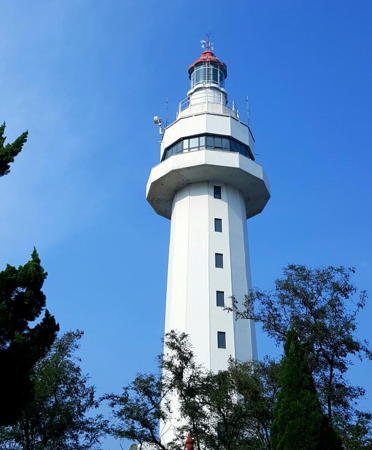
1988 (station established 1905). Active; focal plane 80 m (263 ft); white flash every 9 s. 50 m (164 ft) 12-sided concrete tower with lantern, gallery, and 12-sided observation room. Lighthouse painted white, lantern dome red. A photo is above right, an excellent 2007 photo and a 2009 photo are available, Bob Hughes has a 2013 photo, Tang Liansheng has a 2017 photo, Zachary Weiss has a street view, and Google has a satellite view. The modern lighthouse is the centerpiece of Yāntái Hill Park, which is part of the historic European district. Elevators carry visitors to the observation level. Located atop the hill, which forms a promontory southeast of the harbor. Site open; the tower is open for climbing and is one of the best known attractions of the city. ARLHS PRC-071; CN-1499; Admiralty P3882; NGA 18572.
* Kōngtóngdǎo (Kongtong dǎo, Kungtungtao, Chefoo, "Luson") (1)
1867. Inactive since World War II. The original Chefoo lighthouse was a round stone tower with lantern and gallery, painted with red and white horizontal bands; Huelse has a postcard view. This lighthouse was heavily damaged during World War II. The lowest story of the lighthouse survives, topped by a round concrete tower, much narrower than the original, carrying communications gear. Gordon Snyder has contributed a photo and Google has a satellite view. The name "Luson," once applied to the lighthouse, is that of Lǔ Xùn, the Commissioner of Customs at the Chefoo (Zhīfú) port when construction of the lighthouse began. Located about 75 m (250 ft) west of the new lighthouse. Site open, tower closed.
*** Kōngtóngdǎo (4)
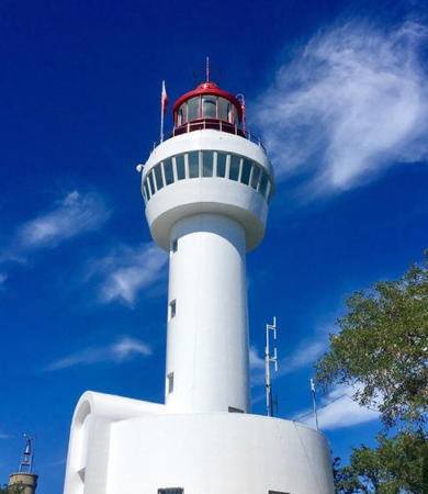
1997 (station established 1867). Active; focal plane 78 m (256 ft); white flash every 15 s. 19 m (62 ft) round cylindrical concrete tower, centered on a round building and carrying a round observation level and a large lantern. Lighthouse covered with white tiles; lantern painted red. A photo is at right and Google has a satellite view. The original lighthouse (previous entry) was replaced by a skeletal tower in 1955 and by a third lighthouse in 1974. Kongtongdǎo is an island about 10 km (6 mi) northeast of the Yāntái waterfront. About 2 km (1.25 mi) long, the island is protected as the Yāntái Kōngtóngdǎo Scenic Area. Transportation is available from Yāntái. According to Snyder, the lighthouse is "accessible by landing the boat on a remote beach on the north side of the island, walking about 0.5 km up a narrow cement road from the beach, then hiking up 233 steep, stone steps to the tower." Located at the northeastern end of the island. Site open; tower open to the observation level. CN-1497; Admiralty P3878; NGA 18596.
Běishí (Pei Shih, Diliuxing, North Rock)
Date unknown. Active; focal plane 28 m (92 ft); two white flashes every 6 s. 4 m (13 ft) square white masonry tower adjacent to a 1-story keeper's cottage or equipment building. No photo available and the island is only a fuzzy spot in Google's satellite view. Located atop an isolated rock about 8 km (5 mi) northeast of Kongtongdǎo. Accessible only by boat. Site status unknown. CN-1490; Admiralty P3880; NGA 18604.


Kōngtóngdǎo Light, Yāntái, May 2019
photo posted by tuniu.com travel site

Information available on lost lighthouses:

Notable faux lighthouses:

Adjoining pages: West: Northwestern Shāndōng | East: Wēihǎi Area

Return to the Lighthouse Directory index | Ratings key

Posted March 31, 2008. Checked and revised August 16, 2023. Lighthouses 42. Site copyright 2023 Russ Rowlett and the University of North Carolina at Chapel Hill.