Lighthouses of China: Northwestern Shāndōng

The People's Republic of China (中华, Zhōnghuá in Chinese) has a lengthy coastline, many large harbors, and a large number of lighthouses. During the colonial period of the late 19th and early 20th centuries Western powers occupied a number of locations in China and built lighthouses, many of which survive. In more recent years the People's Republic has developed modern ports throughout the country and built many lighthouses to serve them.

The People's Republic is divided into 23 provinces and 11 other province-level regions of various special types. Shāndōng (formerly spelled Shantung) is a province of northern China lying directly across the Yellow Sea (Huáng Hǎi) from South Korea. The province includes the Shāndōng Peninsula (Shāndōng Bandǎo), which separates the Yellow Sea from the Bohai Sea (Bó Hǎi). As a result the province has long coastlines facing north on the Bohai Sea and southeast on the Yellow Sea.

Shāndōng is divided into sixteen prefectural-level cities. This page includes lighthouses of the northwestern corner of the province facing the Bohai Sea in the prefectural-level cities of Bīnzhōu, Dōngyíng, and Wéifāng and the western portion of the prefectural-level city of Yāntái.

There are many languages and dialects spoken in China, but Standard Chinese, often called Mandarin, is official. The pīnyīn system for transliterating Chinese into Latin characters is now the international standard but some locations continue to be known also under the spellings of older transliteration systems. The Chinese word for a lighthouse is dēngtǎ (灯塔, "light tower"). In Standard Chinese jiāo (formerly chiao) is a reef or rock, jiǎo is a cape or headland, dǎo (tao) is an island; (tsu) or tuózi ("lump") is a small island, hǎi is a sea, wān is a bay, hǎixiá ("sea valley") is a strait, or jiāng is a river, hékǒu ("river mouth") is an estuary, and gǎng (kang) is a harbor.

Lighthouses in China are maintained by the PRC Maritime Safety Administration. The administration is organized in four regional administrations; Shāndōng lighthouses fall under the Tiānjīn MSA and its district office at Yāntái.

ARLHS numbers are from the ARLHS World List of Lights. CN numbers are Chinese light list numbers. Admiralty numbers are from volume P of the Admiralty List of Lights & Fog Signals. U.S. NGA List numbers are from Publication 112.

General Sources
Online List of Lights - China
Photos by various photographers posted by Alexander Trabas.
World of Lighthouses - China
Photos by various photographers available from Lightphotos.net.
Chinese English Pinyin Dictionary
A useful tool for juggling the representations of Chinese names.
Leuchttürme Chinas auf historischen Postkarten
Historic postcard images posted by Klaus Huelse.
Navionics Charts
Navigation chart for Shāndōng.


Hǔtóuyá (Tigerhead Point) Light, Láizhōu
Láizhōu Tourist Development photo (no longer online)
Bīnzhōu Prefecture Lighthouses

Wúdì County Lighthouses
Bīnzhōu ("Coast Province") faces the shallow western side of the Bohai Sea on the west side of the Yellow River Delta. The city is the home of textiles and automotive industries.
Bīnzhōu Gǎng South
Date unknown. Active; focal plane 15 m (49 ft); green flash every 3 s. 12 m (39 ft) round metal tower painted with green and white horizontal bands. No photo available but Bing has an indistinct satellite view. Located on the west side of the main pier of Bīnzhōu Gǎng. Site status unknown. CN serial 3110033; Admiralty P3906.63.
Bīnzhōu Gǎng North
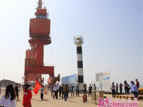
Date unknown. Active; focal plane 14 m (46 ft); white flash every 3 s. 11 m (36 ft) round metal tower painted with black and white horizontal bands. A photo is at right but Bing's satellite view may show an earlier skeletal tower. In order to create a deepwater port for the city, piers have been built at the end of a 12 km (7.5 mi) long trestle. The light is at the end of the main pier of Bīnzhōu Gǎng. Site status unknown. CN-1390.69; Admiralty P3906.64.
Shātóu Pù (?)
Date unknown. Active; focal plane 20 m (66 ft); red flash every 3 s. 10 m (33 ft) square wood tower. No photo available and no tower is seen in Bing's satellite view of the listed location. The Chinese name means "Sand Point Dike." Located on a dune just east of the base of the north pier. Site status unknown. CN-1391; Admiralty P3906.7.
Tào'ěr Estuary East Training Wall
Date unknown. Active; focal plane about 25 m (82 ft); two green flashes every 6 s. Approx. 25 m (82 ft) square skeletal tower. No photo available but Google has a satellite view. Located at the south end of a breakwater off the entrance to the Tào'ěr River on the east side of Bīnzhōu harbor. Site status unknown. CN-1394; Admiralty P3906.655.
Tào'ěr Hépǔ
Date unknown. Active; focal plane 20 m (66 ft); white flash every 4 s. Approx. 20 m (66 ft) square cylindrical skeletal tower. No photo available but Google has a satellite view. Located just off the east bank (hépǔ) of a river on the east side of Bīnzhōu harbor. Site status unknown. CN-1401; Admiralty P3906.6.

North Pier Light, Bīnzhōu Gǎng, September 2017
sd.ifeng.com News photo

Dōngyíng Prefecture Lighthouses

Hékǒu District Lighthouses
Dōngyíng faces the shallow southwestern side of the Bohai Sea straddling the mouth of the Yellow River (Huáng Hé) and at the west entrance to Láizhōu Bay. The city is the home of numerous petroleum-based industries associated with the nearby Shènglì Oil Field. The harbor district is called Hékǒu (River Mouth).

Dōngyíng Liquid Chemical Pier (50,000 Ton Wharf)
Date unknown. Active; focal plane 21 m (69 ft); white flash every 3 s. Approx. 17 m (56 ft) skeletal tower. No photo available and the light is not seen in Google's satellite view. In order to create a deepwater port for the city, piers have been built at the end of a 7 km (4.4 mi) long trestle. Located at the extreme end of the pier, an extension made to accommodate larger ships. Site and tower closed. CN-1415.8055; Admiralty P3906.38.
Dōngyíng Breakwater
Date unknown. Active; focal plane 18 m (59 ft); green flash every 3 s. 12 m (39 ft) round metal tower, painted with green and white horizontal bands. No photo available and the light is not seen in Google's satellite view. Located at the original end of the main pier. Site and tower closed. CN-1415.9; Admiralty P3906.4; NGA 18527.5.
Dōngyíng Breakwater Warning
Date unknown. Active; focal plane 17 m (56 ft); white light, 1 s on, 1 s off. Approx. 13 m (43 ft) skeletal tower. No photo available and the light is not seen in Google's satellite view. Located on a spur on the north side of the main pier about halfway down its length. Site and tower closed. CN-1415.8061; Admiralty P3906.4015.
Dōngyíng Northeast Breakwater
2017. Active; focal plane about 24 m (79 ft); green light, 2 s on, 2 s off. 21.5 m (71 ft) tapered square skeletal tower painted white. A photo is at right but the light is not seen in Google's satellite view. This lighthouse was completed in December 2017 and marks the completion of the "North Breakwater Project," which built a new pier as a northeast spur of the main pier. Site and tower closed. Located at the end of the long breakwater. Admiralty P3906.4031.
Dōngyíng North Basin (Basin R) North Breakwater
2012(?). Active; focal plane 10 m (33 ft); two short green flashes followed by one long green flash every 10 s. 8 m (26 ft) round tile-covered concrete tower, colored white with a green top. No photo available but Google has a satellite view. Located on the north side of the entrance to a harbor basin just east of the long trestle. Site status unknown. CN serial 3110311; Admiralty P3906.408.
Dōngyíng North Basin (Basin R) South Breakwater
Date unknown (before 2009). Active; focal plane 10 m (33 ft); two short red flashes followed by one long red flash every 10 s. 8 m (26 ft) round tile-covered concrete tower, colored white with a red top. No photo available but Google has a satellite view. Located on the south side of the entrance to a harbor basin just east of the long trestle. Site status unknown. Admiralty P3906.409.
Dōngyíng South Basin (Basin S) North Breakwater
2012(?). Active; focal plane 12.5 m (41 ft); three green flashes every 10 s. 8 m (26 ft) round tile-covered concrete tower, colored white with a green top. No photo available but Google has a satellite view. Located on the north side of the entrance to the south harbor basin. Site status unknown. CN-1416.2; Admiralty P3906.41.
Dōngyíng South Basin (Basin S) South Breakwater
Date unknown (before 2009). Active; focal plane 12.5 m (41 ft); three red flashes every 10 s. 8 m (26 ft) round tile-covered concrete tower, colored white with a red top. No photo available but Google has a satellite view. Located on the south side of the entrance to the south harbor basin. Site status unknown. CN-1416.21; Admiralty P3906.42.

Northeast Breakwater Light, Dōngyíng, December 2017,
Dōngyíng Port photo (no longer online)
Dōngyíng South Basin Range Front
Date unknown. Active; focal plane 30.5 m (100 ft); continuous white light. 32.5 m (107 ft) square skeletal tower. No photo available but Google has a satellite view. Located near the waterfront of the south basin. Site status unknown. CN-1416.3; Admiralty P3906.43.
Dōngyíng South Basin Range Rear
Date unknown. Active; focal plane 44.5 m (146 ft); continuous white light. 44.5 m (146 ft) square skeletal tower. No photo available but Google has a satellite view. Located about 600 m (3/8 mi) west southwest of the front light. Site status unknown. CN-1416.31; Admiralty P3906.431.

Wéifāng Prefecture Lighthouses

Wéifāng includes a cluster of industrial cities located at the southern end of Láizhōu Bay.

Shòuguāng City Lighthouse
Shòuguāng Pier West
Date unknown. Active; focal plane 13 m (43 ft); red light, 2 s on, 2 s off. 10 m (33 ft) round barbell-shaped tower colored with black and white horizontal bands. No photo available but Bing has an indistinct satellite view. Located at the west end of the main wharf in Shòuguāng. Site and tower closed. CN serial 3110423; Admiralty P3906.29.
Shòuguāng Pier East
Date unknown. Active; focal plane 13 m (43 ft); white light, 2 s on, 2 s off. 10 m (33 ft) round barbell-shaped tower colored with red and white horizontal bands. No photo available but the light casts a shadow in Bing's satellite view. Located at the east end of the main wharf in Shòuguāng. Site and tower closed. CN serial 3110422; Admiralty P3906.28.

Hántíng District Lighthouses
Wéifāng Gǎng Breakwater (2?)
Date unknown. Active; focal plane about 30 m (98 ft); quick-flashing red light. Approx. 27 m (89 ft) square pyramidal skeletal tower. No photo available but Google has a satellite view. The 2016 CN List places this light on a 6 m (20 ft) red post. Located at the end of the main pier of Wéifāng. Site status unknown. CN-1426.1; Admiralty P3906.27.
Báilàng Hé (2)
Date unknown. Active; focal plane 11 m (36 ft); white flash every 4 s. Approx. 8 m (26 ft) round hourglass-shaped tower colored with red and white horizontal bands. Zhāng Xiètiān has a street view and Bing has a distant satellite view. The 2016 CN list describes a wood tower. Located on the east jetty at the entrance to the Báilàng River in Wéifāng. Site status unknown. CN-1427; Admiralty P3906.26.

Yāntái Prefecture Northwest Coast (Láizhōu and Lóngkǒu) Lighthouses

The large prefectural-level city of Yāntái stretches along more than half of the north coast of the Shāndōng Peninsula; it also includes the Chángshān Islands north of the Peninsula and the city of Hǎiyáng on the south coast of the Peninsula. This page includes only the western end of the prefecture facing Láizhōu Bay. Lighthouses of the north coast are on the Yāntái Area page and those of Hǎiyáng are described on the Wēihǎi Area page. The total population of Yāntái is about 7 million.

Láizhōu City Lighthouses
Láizhōu is a city of about 900,000 residents on the east side of Láizhōu Bay.

*
Hǔtóuyá (Tigerhead Point)
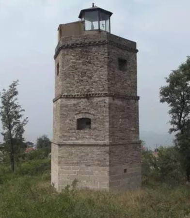
1946. Active; focal plane 42 m (138 ft); two white flashes every 6 s. 15 m (49 ft) hexagonal stone tower with lantern. A photo is at the top of this page and Google has an indistinct satellite view. The tower is unpainted; lantern painted black. The lighthouse was built by local authorities to guide fishermen; it has a spiral wood staircase. Located on a hillside overlooking the southeastern corner of Láizhōu Bay. Site open, tower closed. CN-1430; Admiralty P3906.2.
Pābùhòu (Pabu Rear)
Date unknown. Active; focal plane 16.5 m (54 ft); white flash every 3 s. 11 m (36 ft) white concrete tower. No photo and the lighthouse has not been found in Google's satellite view. Located in a crowded commercial area about 5 km (3 mi) northeast of Hǔtóuyá. Site status unknown. CN-1431; Admiralty P3906.19.
Zhūwàng Gǎng Breakwater
Date unknown. Active; focal plane about 14 m (46 ft); red light, characteristic unknown. Approx. 10 m (33 ft) round barbell-shaped tower, probably colored with red and white horizontal bands. No photo available but Google has a satellite view. Located at the end of the breakwater of an industrial harbor in Láizhōu. Site and tower closed. Not listed by the Admiralty.
Diāolóngzuǐ
Date unknown. Active; focal plane 20.5 m (67 ft); three white flashes every 6 s. Approx. 17 m (56 ft) masonry tower. No photo available but the shadow of the tower is seen in Google's satellite view. Located at the base of a pier at Diāolóng ("Wicked Dragon") Point; this port area was created using fill to connect several islands to the mainland. CN-1435; Admiralty P3906.
Sānshān (Láizhōu Shān)
Date unknown. Active; focal plane 33 m (108 ft); two white flashes every 6 s. 8 m (26 ft) square masonry tower with lantern and gallery. Lighthouse painted white, lantern black. A photo is at right and Google has an indistinct satellite view. This appears to be a historic lighthouse. Located atop a steep bluff above Sānshāndǎo, the Láizhōu fishing port. Site status unknown. CN-1436; Admiralty P3905.5.
Sānshāndǎo West Breakwater
Date unknown. Active; focal plane 13 m (43 ft); quick-flashing green light. 8 m (26 ft) square pyramidal skeletal tower painted with black and white horizontal band. No photo available but Google has an indistinct satellite view. Located at the end of the main breakwater sheltering Sānshāndǎo harbor. Site status unknown. CN-1437.611; Admiralty P3905.365; NGA 18535.1.
Laizhou Shan Light
Láizhōu Shān Light, Láizhōu, May 2013
ex-Panoramio Creative Commons photo by gofman3
Sānshāndǎo Range Front
Date unknown. Active; focal plane 27.5 m (90 ft); continuous red light. Approx. 23 m (75 ft) square skeletal tower painted with red and white horizontal bands. No photo available but Google has a satellite view. This is the entrance range for the Sānshāndǎo harbor. Site status unknown. CN-1437.08; Admiralty P3905.
Sānshāndǎo Range Rear
Date unknown. Active; focal plane 35 m (115 ft); continuous red light. Approx. 30 m (98 ft) square skeletal tower painted with red and white horizontal bands. No photo available but Google has a satellite view. Located about 200 m (1/8 mi) southeast of the front light. Site status unknown. CN-1437.09; Admiralty P3905.1.
Hǎiběizuǐcūn Range Front
Date unknown. Active; focal plane about 18 m (59 ft); red light, pattern unknown. Approx. 15 m (49 ft) square skeletal tower painted with red and white horizontal bands. No photo available but Google has a satellite view. This is the entrance range for the Hǎiběizuǐcūn LNG terminal in Láizhōu. Located on the waterfront of the terminal Site and tower closed. Chated by Navionics but not listed by the Admiralty.
Hǎiběizuǐcūn Range Rear
Date unknown. Active; focal plane about 30 m (98 ft); red light, pattern unknown. Approx. 22 m (72 ft) square skeletal tower painted with red and white horizontal bands. No photo available but Google has a satellite view. Located about 400 m (1/4 mi) southeast of the range light. Chated by Navionics but not listed by the Admiralty.

Lóngkǒu City Lighthouses
Lóngkǒu, a city of about 640,000 residents, is a busy seaport located at the eastern entrance to Láizhōu Bay.
Xīnhángdào (New Channel) Range Front
2007. Active; focal plane 28 m (92 ft); continuous red light. 24 m (79 ft) square pyramidal skeletal tower with gallery, mounted on a square platform. No photo available but Google has a satellite view. This is the approach range for Lóngkǒu for ships arriving from the Bohai Sea. Located about 5 km (3 mi) offshore from Lóngkǒu. Accessible only by boat. Site status unknown. CN-1445.93; Admiralty P3898.5; NGA 18532.5.
Xīnhángdào (New Channel) Range Rear
2007. Active; focal plane 44 m (144 ft); continuous red light. 40 m (131 ft) square pyramidal skeletal tower with gallery, mounted on a square platform and carrying a black diamond-shaped daymark. The area around this light is being reclaimed from the sea. No photo available but Bing has a satellite view. Located 1 km (0.6 mi) southeast of the front light. Accessible only by boat. Site status unknown. CN-1445.94; Admiralty P3898.51; NGA 18532.51.
Lóngkǒu Gǎng Range Front (3)
2008 (station establishment date unknown). Active; focal plane 32 m (105 ft); continuous green light. 30 m (98 ft) skeletal tower mounted atop a building. No photo available but Bing has a satellite view. This light replaced a light on a 25 m (82 ft) square skeletal tower, and NGA formerly listed a 16 m (52 ft) skeletal tower. Located on a pier in Lóngkǒu's inner harbor. Site and tower closed. CN-1441; Admiralty P3898; NGA 18533.
Lóngkǒu Gǎng Range Rear (3)
2008 (station establishment date unknown). Active; focal plane 46 m (151 ft); continuous green light. 43 m (141 ft) round concrete tower painted with red and white horizontal bands. No photo available but Bing has an indistinct satellite view. NGA formerly listed shorter towers for this range. Located beside a major street in Lóngkǒu's harbor district, 400 m (1/4 mi) east of the front light. Site and tower closed. CN-1442; Admiralty P3898.1; NGA 18533.5.
Lóngkǒu Gǎng Berth No. 1
Date unknown. Active; focal plane 12 m (39 ft); red light, 2 s on, 2 s off. 8 m (26 ft) tower. No photo available but Google has a satellite view. Located on the north side of the main wharf. Site and tower closed. CN serial 3410401.01; Admiralty P3897.69.
Lóngkǒu Gǎng Berth No. 27
Date unknown. Active; focal plane 12 m (39 ft); red light, 2 s on, 2 s off. 8 m (26 ft) tower. No photo available but Google has a satellite view. Located at the southwest corner of a large area of recently reclaimed land, wher it marks the north side of the entrance to the main inner harbor. Site and tower closed. CN-1448.114; Admiralty P3898.3.
Shènglì Mǎtóu Hángdào (Victory Dock Channel) Range Front
2008. Active; focal plane 21 m (69 ft); green light, 1 s on, 1 s off. 20 m (66 ft) square skeletal tower, painted black and carrying a black and yellow daymark. No photo available but Google has a satellite view. Located at the waterfront on the north side of Lóngkǒu harbor. Site and tower closed. CN-1451.02; Admiralty P3897.6.
Shènglì Mǎtóu Hángdào (Victory Dock Channel) Range Rear
2008. Active; focal plane 30 m (98 ft); green light, 1 s on, 1 s off. 29 m (95 ft) square skeletal tower, painted black and carrying a black and yellow daymark. No photo available but Google has a satellite view. Located 650 m (0.4 mi) north of the front light. Site and tower closed. CN-1451.03; Admiralty P3897.61.
* Qīmùjiǎo (Qimudǎo, Chimatao) (3)
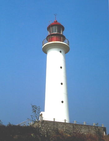
2004 (station established 1871). Active; focal plane 71 m (233 ft); white flash every 5 s. 18 m (59 ft) round tower with lantern and gallery. Lighthouse painted white, lantern red. An MSA photo is above right and Google has a satellite view. The original lighthouse was a 12 m (36 ft) hexagonal stone tower, and this was replaced in 1977 by a 7 m (23 ft) masonry tower. Qīmùjiǎo is the tip of a west-pointing sandy promontory that shelters Lóngkǒu Bay; the end of the peninsula was formerly an island (Qīmùdǎo) that is now connected to the mainland by a sandy isthmus. The area has become well known as a beach resort, with the lighthouse as a tourist attraction. Located at the tip of the peninsula about 12 km (7.5 mi) west of Lóngkǒu. Site open, tower closed. CN-1452; Admiralty P3897; NGA 18532
Huáshíjiāo
Date unknown. Active; focal plane 5.5 m (18 ft); red flash every 3 s. 7 m (23 ft) round masonry tower, probably painted red. No photo available but Google has a satellite view. Located on a reef about 400 m (1/4 mi) south of the waterfront of Sāngdǎo, an island about 2 km (1.25 mi) off the mainland and about 13 km (8 mi) northeast of Lóngkǒu. Accessible only by boat. Site open, tower closed. CN-1453; Admiralty P3896.83.
* Sāngdǎo (Mulberry Island) (2?)
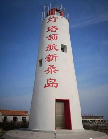
Date unknown. Active; focal plane 21 m (69 ft); two white flashes every 6 s. 10 m (33 ft) round concrete tower with lantern. The lighthouse is white with red trim. A photo is at right and Google has a fuzzy satellite view. This appears to be a historic lighthouse. Located on the southern tip of the island. Site presumably open, tower closed. CN-1454; Admiralty P3896.8.

Information available on lost lighthouses:


Qimujiǎo Light, Lóngkǒu
PRC Maritime Safety Administration Yāntái Office photo


Sāngdǎo (Mulberry Island)
Light, Lóngkǒu
Lóngkǒu Tourist Development photo

Notable faux lighthouses:

Adjoining pages: North: Tiānjīn Area | East: Yāntái Area

Return to the Lighthouse Directory index | Ratings key

Posted March 31, 2008. Checked and revised August 10, 2023. Lighthouses 40. Site copyright 2023 Russ Rowlett and the University of North Carolina at Chapel Hill.