Lighthouses of China: Wēihǎi Area (Eastern Shāndōng)

The People's Republic of China (中华, Zhōnghuá in Chinese) has a lengthy coastline, many large harbors, and a large number of lighthouses. During the colonial period of the late 19th and early 20th centuries Western powers occupied a number of locations in China and built lighthouses, many of which survive. In more recent years the People's Republic has developed modern ports throughout the country and built many lighthouses to serve them.

The country is divided into 23 provinces and 11 other province-level regions of various special types. Shāndōng (formerly spelled Shantung) is a province of northern China lying directly across the Yellow Sea (Huáng Hǎi) from South Korea. The province includes the Shāndōng Peninsula (Shāndōng Bandǎo), which separates the Yellow Sea from the Bohai Sea (Bó Hǎi). As a result the province has long coastlines facing north on the Bohai Sea and southeast on the Yellow Sea.

Shāndōng is divided into sixteen prefectural-level cities. This page includes lighthouses of the prefectural-level city of Wēihǎi, which occupies the eastern end of the peninsula. Also included are lighthouses in the county-level city of Hǎiyáng southwest of Wēihǎi on the south coast of the prefectural-level city of Yāntái.

Because of its strategic location and fine ports, the Shāndōng Peninsula was a target for foreign penetration during the colonial period. The urban area of Wēihǎi was a leased British territory known as Wei-Hai-Wei from 1898 to 1930, and Yāntái also had a large European presence. The entire province was occupied by Japan during World War II (1938-1945).

There are many languages and dialects spoken in China, but Standard Chinese, often called Mandarin, is official. The pīnyīn system for transliterating Chinese into Latin characters is now the international standard but some locations continue to be known also under the spellings of older transliteration systems. The Chinese word for a lighthouse is dēngtǎ (灯塔). In Standard Chinese jiāo (formerly chiao) is a reef or rock, jiǎo is a cape or headland, dǎo (tao) is an island; (tsu) or tuózi ("lump") is a small island, hǎi is a sea, wān is a bay, hǎixiá is a strait, or jiāng is a river, hékǒu ("river mouth") is an estuary, and gǎng (kang) is a harbor.

Lighthouses in China are maintained by the PRC Maritime Safety Administration. The administration is organized in four regional administrations; Shāndōng lighthouses fall under the Tiānjīn MSA and its district office at Yāntái.

ARLHS numbers are from the ARLHS World List of Lights. CN numbers are Chinese light list numbers. Admiralty numbers are from volume P of the Admiralty List of Lights & Fog Signals. U.S. NGA List numbers are from Publication 112.

General Sources
Online List of Lights - China
Photos by various photographers posted by Alexander Trabas.
World of Lighthouses - China
Photos by various photographers available from Lightphotos.net.
Chinese English Pinyin Dictionary
A useful tool for juggling the representations of Chinese names.
Leuchttürme Chinas auf historischen Postkarten
Historic postcard images posted by Klaus Huelse.
Navionics Charts
Navigation chart for Shāndōng.


Chéngshānjiǎo Light, Róngchéng, February 2011
Google Maps photo by Qi Wang

Wēihǎi Prefecture Lighthouses

Wēihǎi City (Huáncuì District) Lighthouses
Wēihǎi is a port near the eastern tip of the Shāndōng Peninsula. In 1898, after Russia occupied Lüshun (Port Arthur) on the other side of the Bohai Gulf, Britain secured a lease of the Wēihǎi area as a competing naval base. The British occupied the territory, known as Wei-hai-wei (Wēihǎi Garrison), until 1930.

Shuāngdǎo Gǎng
Date unknown. Active; focal plane 16 m (52 ft); two white flashes every 6 s. 7 m (23 ft) round stone tower. No photo available but Google has a satellite view. Located on the east side of the entrance to Shuāngdǎo harbor, on the west side of Wēihǎi city. Site status unknown. CN-1512; Admiralty P3877.
Jìngzǐtóu (Jingzi Tou, Ching-tsu t'ou) (2)
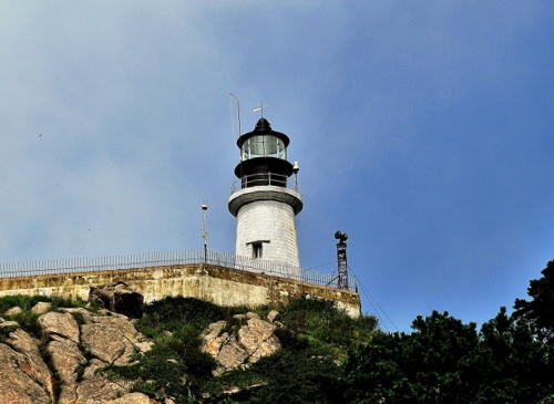
1975 (station established 1953). Active; focal plane 92 m (302 ft); white flash every 15 s. 8 m (26 ft) round cylindrical concrete tower with lantern and gallery. Tower painted white, lantern black. A photo is at the top of this page and Google has a satellite view. Jìngzǐtóu is a sharp, narrow promontory projecting northward into the sea about 8 km (5 mi) north of Wēihǎi. The original lighthouse was a skeletal tower. Located at the tip of the peninsula. Site open, tower closed. CN-1513; Admiralty P3876; NGA 18600.
Yáshídǎo (Yáshí dǎo)
Date unknown. Active; focal plane 14 m (46 ft); green flash every 5 s. 5.5 m (16 ft) round stone tower, painted white. No photo available but Google has a distant satellite view. Located at the end of a rocky reef on the west side of the entrance to Wēihǎi harbor. Accessible only by boat. Site status unknown. CN-1517; Admiralty P3874; NGA 18620.
Wēihǎi Range Front (?)
Date unknown. Active; focal plane 31 m (102 ft); continuous red light. 10 m (33 ft) skeletal tower atop an 8-story building. The tower appears doubled in a Google street view but Google's satellite view suggests that the light has been removed due to ongoing construction in the area. Site status unknown. CN-1528.1; Admiralty P3871.7; NGA 18626.

Jìngzǐtóu Light, Wēihǎi, 2015
kknews.cc tourist development photo
Wēihǎi Range Rear
Date unknown. Active; focal plane 41 m (135 ft); continuous red light. 37 m (121 ft) skeletal tower. No photo available and the tower is hard to see in Google's satellite view (it's between the large white building and the long dark one; turn the labels off). Site status unknown. CN-1528.11; Admiralty P3871.71; NGA 18626.1.
Wēihǎi Pier North Side (2)
Date unknown. Active; focal plane 23 m (75 ft); quick-flashing red light. 19 m (62 ft) robust round post with gallery. The light is at the left in Syon Han's photo, Charles Jong has a distant view, and Google has a satellite view. The original light was on a square skeletal tower. Located at the northeast corner of the main Wēihǎi pier. Site and tower closed. CN-1528.2; Admiralty P3871.63; NGA 18628.
Wēihǎi Pier South Side (2)
Date unknown. Active; focal plane 23 m (75 ft); continuous red light. 19 m (62 ft) square skeletal tower painted with black and white horizontal bands. No photo available but the shadow of the tower is seen in Google's satellite view. The original light was on a square skeletal tower. Located at the southeast corner of the main Wēihǎi pier. Site and tower closed. CN-1528.30; Admiralty P3871.6; NGA 18628.5.
* Wēihǎi Shipyard Pier (2)
Date unknown. Active; focal plane about 14 m (46 ft); continuous red light. Approx. 10 m (33 ft) round white concrete tower with gallery. Shi Jiangchuan has a street view and Google has a satellite view. The 2016 Chinese list describes a much shorter metal tower. The Shipyard Pier is now a public pier; moored alongside is a replica of the battleship Dìngyuǎn, the flagship of the Chinese Navy during the Sino-Japanese War of 1894-95. Site open, tower closed. CN-1530; Admiralty P3871.5.
Qígānzuǐ (Qigan Zui, Flagstaff Point) (3)
1976 (station established 1898). Active; focal plane 23.5 m (77 ft); white flash every 12 s. 11 m (36 ft) round cylindrical concrete tower, attached to a 1-story equipment building. Lighthouse painted white. A photo is at right and Google has a satellite view. This light station replaced an 1890 lighthouse built nearby on Observatory Island; that light had been destroyed in the Sino-Japanese War of 1894-95. The 1898 lighthouse, built by the British for the Chinese Maritime Customs Department, was a short wrought iron tower with a focal plane of 16 m (53 ft). It was destroyed by Japanese naval gunfire in 1945. A skeletal tower replaced it in 1951. It appears that the original keeper's houses of the station survive. Located on a steep-sided rock in an area recently redeveloped. Site status unknown. ARLHS PRC-052; CN-1531; Admiralty P3871; NGA 18624.

Qígānzuǐ (Flagstaff Hill) Light, Wēihǎi, May 2018
photo by Wang Jihua Photography
published by xuehua.us (Snowflake News)
Liúgòngdǎo (Dàhóng East Entrance, Liugong)
Date unknown. Active; focal plane 10 m (33 ft); white flash every 5 s. 7 m (23 ft) round stone tower painted with red and white horizontal bands. The light is visible in the distance right of center in Alex Su's photo (zoom in!) and Google has a satellite view. Located on a rocky shoal off the eastern end of Liúgòngdǎo, a large island that shelters the harbor of Wēihǎi. Accessible only by boat. Site status unknown. CN-1537; Admiralty P3870; NGA 18612.
Liúgòngdǎo Pier
Date unknown. Active; focal plane and light characteristic unknown. Approx. 9 m (30 ft) round hourglass-shaped fiberglass tower colored with red and white horizontal bands. No photo available but Google has a satellite view. Located at the end of a breakwater at the western end of Liúgòngdǎo. Site status unknown. Not listed by the Admiralty.
Rìdǎo (Rì Dǎo)
1953. Active; focal plane 19 m (62 ft); two white flashes every 6 s. 5 m (16 ft) round tower with gallery, painted white. No photo available but Google has a satellite view. Located atop a small island in the center of the entrance to Wēihǎi harbor, about 3 km (1.8 mi) south of the Liúgòngdǎo lighthouse. Accessible only by boat. Site status unknown. CN-1538; Admiralty P3869; NGA 18616.
Zhàoběizuǐ (Zhaobei Zui, Chaopeitsui, Wei-hai-wei)
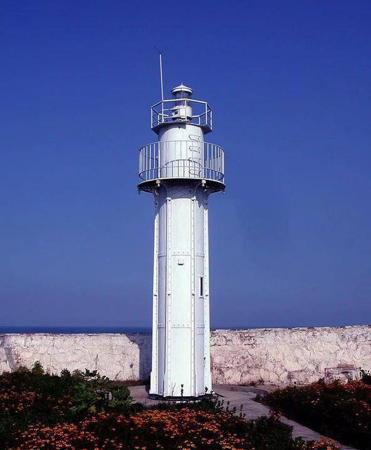
1891 (British). Active; focal plane 29 m (95 ft); white flash every 8 s. 9 m (30 ft) round cylindrical cast iron tower with gallery and eight ribs, painted white. Lantern removed. This small lighthouse, prefabricated in France by Sauter, Lemonnier & Cie., was installed during the British occupation of Wēihǎi. A Wēihǎi Daily photo is at right and Huelse has a historic postcard view. Google's satellite view shows heavy construction of new port facilities in the area surrounding the lighthouse but the lighthouse is protected from this development. It appears that the keeper's house shown in Huelse's view has been demolished. The lighthouse was dismantled during the Sino-Japanese War of 1894-95 and then reassembled. Located at the tip of a promontory on the east side of Wēihǎi Bay, about 11 km (7 mi) east southeast of the city. Site status unknown. CN-1539; Admiralty P3868; NGA 18608.


Zhàoběizuǐ Light, Wēihǎi, 2021
Wēihǎi Daily photo


Róngchéng City (Chéngshānjiǎo Area) Lighthouses
The county-level city of Róngchéng occupies the eastern extremity of the Shāndōng Peninsula. The city has a population of about 700,000.

Jīmíngdǎo (Jīmíng dǎo, Chi-ming Tao) (2?)
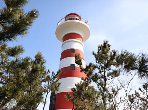
1953. Active; focal plane 77 m (253 ft); white flash every 10. 8 m (26 ft) round cylindrical stone tower with gallery, adjacent or attached to a 1-story stone keeper's house. Tower painted with red and white horizontal bands. Next to the current lighthouse is a shorter stone tower that appears to be an older lighthouse. A photo and a second photo (last photo in the article) are available and Google has a satellite view. In 2020 plans were announced to replace the lighthouse with a 20 m (66 ft) lighthouse. Jīmíngdǎo (Cock-crow Island) is a small island about 3 km (2 mi) off the north coast of the Chéngshānjiǎo cape, about 20 km (13 mi) northwest of JiuRóngchéng. Located on the highest point of the island. Accessible only by boat. Site status unknown. CN-1540; Admiralty P3867; NGA 18634.
* Lóngyǎnwān Range Front
Date unknown. Active; focal plane 18 m (59 ft); continuous red light. Approx. 15 m (49 ft) square concrete tower painted with red and white horizontal bands. No photo available but Google has a satellite view. Located on the beach at a small harbor about 8 km (5 mi) west of Chéngshānjiǎo. There is a parking lot at the lighthouse. Site open, tower closed. CN-1540.6; Admiralty P3866.5.
Lóngyǎnwān Range Rear
Date unknown. Active; focal plane 25 m (82 ft); continuous red light. Approx. 20 m (66 ft) square concrete tower painted with red and white horizontal bands. No photo available but Google has a satellite view. Site status unknown. CN-1540.61; Admiralty P3866.51.
 

Jīmíngdǎo Light, Róngchéng, March 2021
thepapaer.cn travel development photo
 
Hǎilǘdǎo (Hǎilǘ dǎo, Hai-lu Tao, Alceste Island) (3?)
1990 (station established 1953). Active; focal plane 71.5 m (235 ft); white flash every 5 s. 7 m (23 ft) hexagonal cylindrical concrete tower, attached to a small 1-story concrete equipment shelter. Lighthouse painted white. A closeup photo is seen at right, Alan Young has a distant photo, and Google has a satellite view. The original light was on a skeletal tower and NGA describes the 7 m (23 ft) round stone tower built in 1976. Hǎilǘdǎo (Sea-donkey Island) is a small island about 5 km (3 mi) off the coast and and 8 km (5 mi) northwest of Chéngshānjiǎo. Located on the highest point of the island. Accessible only by boat. Site status unknown. CN-1541; Admiralty P3866; NGA 18636.
** Chéngshānjiǎo (Chengshantou, Shantung Promontory Northeast, Cape Shantung) (4)
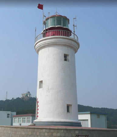
1950 (station established 1821). Active; focal plane 60 m (198 ft); white light, 3 s on, 2.5 s off, 3 s on, 11.5 s off. 16 m (52 ft) round stone tower with lantern and gallery. Lighthouse painted white, lantern red. Qi Wang's closeup photo is at right, Lee Byung Hwan has a 2017 photo, and Google has a satellite view of the station. Chéngshānjiǎo, the easternmost tip of the Shāndōng Peninsula, was often called "Cape Shantung" by Western navigators during the colonial period. The lighthouse here is a well-known tourist destination. The 1874 lighthouse built by the British replaced a 6 m (20 ft) tower built in 1864, but lights had been displayed from masts as early as 1821. The British lighthouse was destroyed during World War II. The clamshell Fresnel lens of the British lighthouse was stored during the war and is on display at the Qínhuángdǎo lighthouse in Héběi province. Naturally the site commands a wide view of the Yellow Sea (Huánghǎi). Accessible by road. Site open; the tower may also be open but we have no details on this. ARLHS PRC-015; CN-1542; Admiralty P3864; NGA 18640.
Cǎodǎo
Date unknown. Active; focal plane 36 m (118 ft); white light, 2 s on, 2 s off. Listed as a 13 m (43 ft) square brick tower, painted white; it appears that the light is now shown from a tall mast atop the tower. No photo available but Google has a satellite view. Located on a promontory in the entrance to a small harbor in northern Róngchéng, about 15 km (9 mi) southwest of Chéngshānjiǎo. Site status unknown. CN-1548; Admiralty P3863.5.
Yāndūnjiǎo North Pier (Outfitting Work Pier)
Date unknown. Active; focal plane 13 m (43 ft) red light, 2 s on, 2 s off. 8 m (26 ft) round tower on a square base. No photo available but Google has a satellite view. Located at the end of an industrial pier in Liánluò Bay. Site and tower closed. CN serial 3510382; Admiralty P3863.4.
Yāndūnjiǎo South Pier
Date unknown. Active; focal plane 10 m (33 ft) 2 s on, 2 s off. 6 m (20 ft) round tower on a square base. No photo available but Google has a satellite view. Located at the end of an industrial pier in Liánluò Bay. Site and tower closed. CN serial 3510383; Admiralty P3863.3.

Hǎilǘdǎo Light, Róngchéng
Qunar.com travel development photo
Jiāyè Pier
Date unknown. Active; focal plane 14 m (46 ft); red light, 2 s on, 2 s off. 9 m (30 ft) steel post light with gallery, painted with black and red horizontal bands. No photo available but Google has a satellite view. Located on an industrial quay at Lǐdǎo, in the lee of the Wàizhèdǎo promontory (next entry). Site status unknown. CN-1554.1; Admiralty P3863.1.
Wàizhèdǎo (Lǐdǎo)
Date unknown. Active; focal plane 49 m (161 ft); white flash every 8 s. 14 m (46 ft) round stone tower with gallery, painted white. The light can be seen atop the headland in Peder Kolbeinshavn's photo of the cape (zoom in) and Google has an indistinct satellite view. Located on a wooded promontory at Lǐdǎo, about 25 km (15 mi) southwest of Chéngshānjiǎo. Site status unknown. CN-1554; Admiralty P3863; NGA 18644.
Mǎtājiǎo
Date unknown. Active; focal plane 20 m (66 ft); two white flashes every 10 s. 7 m (23 ft) round concrete tower. No photo available but Google has an indistinct satellite view. Located on a sharp promontory about 7 km (4.5 mi) southeast of Wàizhèdǎo. Site status unknown. CN-1558.1; Admiralty P3862.1.
* Hǎimāozǐtóu (2)
1980 (station established 1963). Active; focal plane 75 m (246 ft); white flash every 12 s. 14 m (46 ft) round stone tower with lantern and gallery, adjacent or attached to a 1-story stone keeper's house. Lighthouse painted white, lantern black. Google has a good satellite view. This lighthouse marks the northern entrance to Sānggōu Wān, a partially sheltered bay at the eastern end of the Shāndōng Peninsula. Located at the tip of a promontory about 18 km (11 mi) east of Róngchéng. Site status unknown, but the lighthouse should be visible from nearby. ARLHS PRC-030; CN-1559; Admiralty P3862; NGA 18648.
Chǔdǎozuǐ (?)
Date unknown. Active; focal plane 17 m (56 ft); two white flashes every 5 s. Approx. 12 m (39 ft) round white concrete tower. No photo available and no tower is seen in Google's satellite view. Located at the tip of a sharp headland at the southern entrance to Sānggōu Wān. Site status unknown. CN-1560; Admiralty P3861.
Mòyédǎo (Mòye dǎo, Shantung Promontory Southeast) (3)
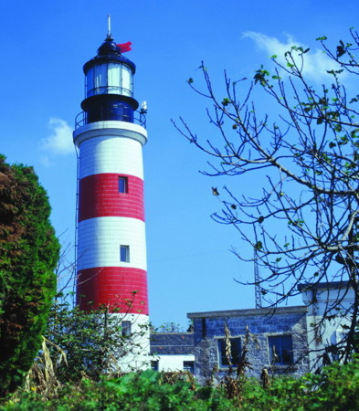
1956 (station established 1883). Active; focal plane 28 m (92 ft); white flash every 15 s. 27 m (89 ft) round stone tower with lantern and gallery, adjacent or attached to a 1-story stone keeper's house. Lighthouse covered with tiles in red and white horizontal bands; lantern painted black. This appears to be a staffed lighthouse. An MSA photo is at right, additional photos are available, and Google has a satellite view. The original lighthouse was a cast iron tower of very similar size and appearance; Klaus Huelse has a historic postcard view. According to MSA that lighthouse was destroyed during World War II. It was replaced with a temporary light until the present lighthouse was built. This light marks the southeastern corner of the blunt eastern end of the Shāndōng Peninsula. Located on an island, now joined to the mainland by fill and causeways, near the town of Dàzhuāng. Site status unknown; the lighthouse appears to be on the grounds of some kind of government institution. ARLHS PRC-042; CN-1561; Admiralty P3860; NGA 18652.
Shídǎo Gǎng
Date unknown. Active; focal plane 13 m (43 ft); red flash every 4 s. 8 m (26 ft) round fiberglass tower colored with red and white horizontal bands. No photo available but Google has a satellite view. Located on a pier on the west side of Shídǎo Bay, a harbor sheltered by Mòyédǎo. This appears to be a coast guard station. Site status unknown. CN-1572; Admiralty P3859.6.
Dàyúdǎo
Date unknown. Active; focal plane 11 m (36 ft); continuous white light. 7 m (23 ft) square stepped stone tower with lantern, painted white. No photo available but Google has a satellite view. Located at a small harbor about 15 km (9 mi) southwest of Mòyédǎo. Site status unknown. CN-1579; Admiralty P3859.5.
Moyedao Light
Mòyédǎo Light, Wánglián District, Róngchéng
PRC Maritime Safety Administration photo
Zhǔkǒu
Date unknown. Active; focal plane 44 m (144 ft); three white flashes every 10 s. 13 m (43 ft) round stone tower, painted white. No photo available but Google has a satellite view. Located on a promontory south of Shídǎo. Site status unknown. CN-1585; Admiralty P3859.
Sūshāndǎo (Sūshān dǎo, Staunton Island) (2)
1982 (station established 1957). Active; focal plane 116 m (381 ft); white flash every 25 s. 10 m (33 ft) round stone tower with lantern and gallery. Lighthouse painted white, lantern black. A photo is at right and Google has a satellite view. Sūshāndǎo is an island about 2 km (1.25 mi) long and 500 m (0.4 mi) wide located about 8 km (5 mi) offshore and 11 km (7 mi) southeast of Jīnghǎiwēi. Located on the highest point of the island. ARLHS PRC-058; CN-1586; Admiralty P3858; NGA 18656.
Fēnghuángwēi
Date unknown. Active; focal plane 26 m (85 ft); two white flashes every 6 s. 11 m (36 ft) round stone tower. No photo available but Google has a satellite view. This light marks the east side of the entrance to Jīnghǎi Bay. Located on a small island off Jīnghǎijiǎo, a sharp promontory about 30 km (19 mi) west of Mòyédǎo. Site status unknown. CN-1587; Admiralty P3857.8.

Wéndēng District Lighthouses
In 2014 the former county-level city of Wéndēng was converted to an urban district of Wēihǎi. The district faces south on the Yellow Sea southwest of Róngchéng.

Wǔgùdùn (Lǎolǘbózi, Donkey Neck)
Date unknown. Active; focal plane 44 m (144 ft); two white flashes every 6 s. 11 m (36 ft) round stone tower, painted white. No photo available but Google has a satellite view. Located on a sharp promontory about 14 km (9 mi) southeast of Zékùzhēn. Site status unknown. CN-1590; Admiralty P3857.6.

Sūshāndǎo Light, Róngchéng, September 2010
anonymous ZOL Forum photo (no longer online)
Niúxīndǎo (2?)
Date unknown. Active; focal plane 40 m (131 ft); white flash every 6 s. Approx. 10 m (33 ft) round white concrete tower. No photo available but Google has a satellite view. The Admiralty lists a 4 m (13 ft) round stone tower, but the satellite view and photo strongly suggest a newer and taller tower. Located on a small island off Nánhǎi harbor. Accessible only by boat. Site status unknown. CN-1597.5; Admiralty P3857.4.

Rǔshān City Lighthouses
The county-level city of Rǔshān is known for its seafood industry. The city has a population of about 600,000.

Làngnuǎnkǒu
Date unknown. Active; focal plane 12.5 m (41 ft); three white flashes every 6 s. 10 m (33 ft) square cylindrical stone tower painted white. No photo available but Google has a very distant satellite view. This inlet was formerly silted up but it has been opened recently as a fishery harbor. Located at the east side of the entrance to Làngnuǎnkǒu. Site status unknown. CN-1598; Admiralty P3857.3.
Fènghuángzuǐ (Phoenix Point)
Date unknown. Active; focal plane 20 m (66 ft); white flash every 4 s. 7 m (23 ft) round stone tower painted white. No photo available and the tower is not seen clearly in Google's indistinct satellite view. Located on a headland about 20 km (13 mi) northeast of Nánhuángdǎo. Site status unknown. CN-1600; Admiralty P3857.2.
Nánhuángdǎo
Date unknown. Active; focal plane and light characteristic unknown. 5 m (17 ft) round white stone tower painted white. No photo available but Google has a satellite view. The Navionics chart shows this lighthouse active. Located at the south end of an island off Tǎdǎo at the southwestern corner of Wéndēng. Site status unknown. CN-1604; not listed by the Admiralty.
Nánhuángdǎo Pier
2017. Active; focal plane 8 m (26 ft); white light, 2 s on, 2 s off. 6 m (20 ft) square concrete tower painted yellow. No photo available but Google has an indistinct satellite view. Located on the pier on the west side of Nánhuángdǎo. Site status unknown. Admiralty P3856.85.
Pǔdǎo (2?)
Date unknown. Active; focal plane 58 m (190 ft); white flash every 3 s. Approx. 7 m (23 ft) round white concrete tower. No photo available but Google has a fuzzy satellite view. The Admiralty lists a 4 m (13 ft) round stone tower but the present light must be taller to be visible above the trees seen in the satellite view. Located on a small island just off the mainland about 8 km (5 mi) west of Nánhuángdǎo. Accessible only by boat. Site status unknown. CN-1606; Admiralty P3856.75.
Qǔjiǎo Shí
Date unknown. Active; focal plane about 10 m (33 ft); white flash every 4 s. 5 m (17 ft) round white stone tower. No photo available but Bing has a satellite view. Located on a rocky reef in the entrance to Rǔshān harbor. Accessible only by boat. Site status unknown. CN-1612; Admiralty P3856.66.
Pípadǎo (2?)
Date unknown. Active; focal plane 11 m (36 ft); red flash every 4 s. Approx. 7 m (23 ft) round white concrete tower. No photo available but Google has a satellite view. The Admiralty lists a 4 m (13 ft) round stone tower but the present light appears taller in the satellite view. Located on a near island (connected to the mainland by a narrow isthmus) marking the west side of the entrance to the Rǔshān estuary. Site status unknown. CN-1611; Admiralty P3856.64.

Yāntái Prefecture South Coast Lighthouses

Hǎiyáng City Lighthouses
Known for its beach resorts, the county-level city of Hǎiyáng is part of the prefectural-level city of Yāntái. The population is about 700,000.

Cǎodǎozuǐ
Date unknown. Active; focal plane 8 m (26 ft); white flash every 3 s. 5 m (17 ft) round cylindrical white concrete tower. No photo available but Google has a satellite view. Located on a former island (now connected to the mainland by a quay) at the southeastern corner of Hǎiyáng. Site status unknown. CN-1613; Admiralty P3856.6.
Lǎolóngtóu (2)
Date unknown. Active; focal plane 16 m (52 ft); white flash every 6 s. Approx. 13 m (43 ft) round stone tower. No photo available but Google has a satellite view. Located at a tank farm on a large pier at Fèngchéngzhèn. Site status unknown. CN-1615; Admiralty P3856.3; NGA 18661.
Fèngchéng Pier
Date unknown. Active; focal plane about 16 m (52 ft); white flash every 6 s. 12 m (39 ft) round red tower. No photo available but Google has a satellite view. Located on the pier at Fèngchéngzhèn. Site status unknown. CN-1616; Admiralty P3856.29; NGA 18661.2.
Jīnshílán
Date unknown. Active; focal plane about 12 m (39 ft); two white flashes every 6 s. 8 m (26 ft) round white concrete tower. No photo available and the light is not shown in Google's fuzzy satellite view of the reef. Located on a rocky reef about 15 km (9 mi) northeast of the Dīngzì estuary entrance. Accessible only by boat. Site status unknown. CN-1619; Admiralty P3856.28.
Dīngzìzuǐ (2?)
Date unknown. Active; focal plane unknown; white light, pattern unknown. Listed as a 7.5 m (25 ft) white masonry tower; it looks at least twice that tall in Google's satellite view. No photo available. Located on the north side of the entrance to the Dīngzì estuary, the border between Yāntái and Qīngdǎo prefectures. Site status unknown. CN-1620; Admiralty P3856.25.
Dīngzì Hé Yá Dǎo (Dīngzì River Duck Island) (2?)
Date unknown. Active; focal plane unknown; white light, pattern unknown. Listed as a 6 m (20 ft) white masonry tower; it looks taller in Google's satellite view. No photo available. Located near the north end of the Dīngzì River Bridge. Site status unknown. CN-1621; Admiralty P3856.22.

Information available on lost lighthouses:

Notable faux lighthouses:

Adjoining pages: Northwest: Yāntái Area | Southwest: Qīngdǎo

Return to the Lighthouse Directory index | Ratings key

Posted March 31, 2008. Checked and revised August 23, 2023. Lighthouses 47. Site copyright 2023 Russ Rowlett and the University of North Carolina at Chapel Hill.