Lighthouses of China: Dàishān Islands, Zhèjiāng

The People's Republic of China (中华, Zhōnghuá in Chinese) has a lengthy coastline, many large harbors, and a large number of lighthouses. The country is divided into 23 provinces and 11 other province-level regions of various special types. The Chinese province of Zhèjiāng (formerly spelled Chekiang) occupies the central coast of the country, south of Shànghǎi and north of the Formosa Strait. The province faces east on the East China Sea. For the most part the coastline is hilly and irregular, with more than 3000 islands of all sizes offshore.

Hángzhōu Bay is a large embayment at the northern end of the province. Spread across the mouth of Hángzhōu Bay, the Zhōushān Islands include well over 1000 islands, although only 103 are large enough to be inhabited. Lighting this maze of islands requires hundreds of beacons of all sizes. The islands are organized as Zhōushān City,, one of the eleven prefectural-level cities of Zhèjiāng Province. This page covers lighthouses of Dàishān County, including the islands of Qúshān, Dàishān, and Chángtúshān, plus the Zhōngjiēshān Islands to the east of Chángtúshān. These islands are in the center of the archipelago, north of the main Zhōushān Island and south of the Shèngsì Islands.

There are many languages and dialects spoken in China, but Standard Chinese, often called Mandarin, is official. The pīnyīn system for transliterating Standard Chinese into Latin characters is now the international standard but some locations continue to be known also under the spellings of older transliteration systems. The Chinese word for a lighthouse is dēngtǎ (灯塔). In Standard Chinese jiāo (formerly chiao) is a reef or rock, jiǎo is a cape or headland, dǎo (tao) is an island; (tsu) or tuózi ("lump") is a small island, hǎi is a sea, wān is a bay, hǎixiá is a strait, or jiāng is a river, hékǒu ("river mouth") is an estuary, and gǎng (kang) is a harbor.

Lighthouses in China are maintained by the PRC Maritime Safety Administration. The administration is organized in four regional administrations, with offices in the major ports. All the lights on this page are maintained by the Zhènhǎi MSA office.

ARLHS numbers are from the ARLHS World List of Lights. CN numbers are Chinese light list numbers. Admiralty numbers are from volume P of the Admiralty List of Lights & Fog Signals. U.S. NGA List numbers are from Publication 112.

General Sources
Online List of Lights - China
Photos by various photographers posted by Alexander Trabas.
Zhōushān Lighthouses
Photos of nineteen of the best-known lighthouses of the islands.
Chinese English Pinyin Dictionary
A useful tool for juggling the representations of Chinese names.
Navionics Charts
Navigation chart for Zhèjiāng


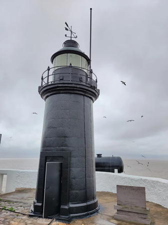
Xiàsānxīng Light, Qúshāndǎo, October 2022
Daishan News photo
Bái Jiéxià Strait (Bonham Strait) Lighthouses
These are the northernmost lighthouses of Dàishān County. The Bái Jiéxià Strait (known to Western navigators historically as the Bonham Strait) is an important entrance to the Hángzhōu gulf passing the south side of Huanglong Shān and Sìjiāo in Shèngsì County. Lighthouses on the eastern portion of the strait are described on the Shèngsì County page.

Cháishān
Date unknown. Active; focal plane 16.5 m (54 ft); white flash every 5 s. 11 m (36 ft) round cylindrical concrete tower, colored with black and white horizontal bands. No photo available but Google has a satellite view. Located at the east end of Cháishān, a small island at the east end of the Chuānshān Islands, on the south side of the strait opposite the Bànyángjiāo lighthouse. Accessible only by boat. Site open, tower closed. CN-2320.05; Admiralty P3718.875.
Chuānmùzhuāngshān (Chuānmùzhuāng shān )
Date unknown. Active; focal plane 15.5 m (50 ft); white flash every 4 s. 11 m (36 ft) round cylindrical white concrete tower. No photo available but Google has a satellite view. Located at the south end of a small island at the southern end of the Chuānshān Islands. Accessible only by boat. Site open, tower closed. CN-2320.07; Admiralty P3718.865.
Huāpíngshān (Huāpíng Shān)
Date unknown. Active; focal plane 14 m (46 ft); two white flashes every 4 s. 11 m (36 ft) round cylindrical concrete tower colored with red and white horizontal bands. No photo available but Google has a satellite view. Located on an islet about 2 km (1.25 mi) northwest of the Cháishān light. Accessible only by boat. Site open, tower closed. CN-2320.03; Admiralty P3718.87.
Bítóujiāo (Bítóu Jiāo) (3)
2005 (station established 1954). Active; focal plane 38 m (125 ft); white flash every 6 s. 12 m (39 ft) round concrete tower with lantern and gallery. Lighthouse painted white with purple trim; lantern painted purple. The lighthouse replaced a smaller 1989 tower. No photo available but Bing has an indistinct satellite view. Located on an isolated rock about 25 km (15 mi) southwest of Sìjiāo. Accessible only by boat. Site open, tower closed. CN-2321; Admiralty P3718.85.

Fēngcháoyán Lighthouse
Fēngcháoyán (Fēngcháo Yán, Honeycomb Rock)
Date unknown. Active; focal plane 26 m (85 ft); white flash every 10 s. 11 m (36 ft) round white concrete tower. No photo available but Bing has an indistinct satellite view. Located on a small and remote island about 35 km (22 mi) west southwest of Zhōngkuídǎo and 16 km (10 mi) east southeast of Xiasanxing. Accessible only by boat. Site and tower closed. CN-2336; Admiralty P3728; NGA 18900.

Sānxīng Islands Lighthouses
The Sānxīng Islands (sometimes called the Hobson Islands by Western navigators) are a group of small islands to the east of Qúshāndǎo.
* Xiàsānxīngdǎo (Hsia-san-hsing Tao, Elgar Island) (2)
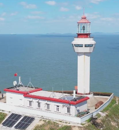
1993 (station established 1912). Active; focal plane 79 m (259 ft); three white flashes every 20 s. 27 m (89 ft) hexagonal cylindrical concrete tower with lantern and gallery, attached to a 1-story concrete keeper's house. A 2022 photo is seen at the top of this page and Google has a satellite view of the station. Xiàsānxīng is an islet an eastern end of the Sānxīng Islands. Located on the highest point of the island. Accessible only by boat, but tours to the island and light station are available. Site open, tower closed. ARLHS PRC-066; CN-2335; Admiralty P3734; NGA 18896.
Sānxīngwūjiāo
Date unknown. Active; focal plane 8 m (26 ft); two white flashes every 5 s. 8 m (26 ft) round concrete tower painted black with one red horizontal band. No photo available and the tower is hard to distinguish in Google's satellite view. Located on a reef at the western end of the Sānxīng Islands. Accessible only by boat. Site open, tower closed. CN-2334.5; Admiralty P3734.3.

Qúshāndǎo (Tsu Shan Tao) Area Lighthouses
Northernmost of the larger islands of the Zhōushān archipelago, Qúshāndǎo is about 15 km (9 mi) long and 3-5 km (2-3 mi) wide.

Guānyīnshān
Date unknown. Active; focal plane 40 m (131 ft); white flash every 2 s. 8 m (26 ft) round white concrete tower. No photo available but Bing has a satellite view. Located on the southwestern tip of Qúshāndǎo. Site status unknown. CN-2330.1; Admiralty P3719.2.
Pípálán (Pípálándǎo) (2?)
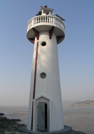
2006(?) (station establishment 2001). Active; focal plane 13 m (43 ft); two white flashes every 6 s. 11 m (36 ft) round concrete tower with gallery, painted white with dark red trim. Shànghǎi MSA's photo is at right and Bing has a satellite view. Located on an island sheltering a fishing port at the west end of Qúshāndǎo. Accessible only by boat. Site status unknown. CN-2330; Admiralty P3719.
Làitóuzhì (2)
1978 (station established 1953). Active; focal plane 37 m (121 ft); three white flashes every 12 s. 9 m (30 ft) round concrete tower with gallery, painted white. No photo available but Bing has a satellite view. Located on a small island off the west coast of Qúshāndǎo. Accessible only by boat. Site status unknown. CN-2329; Admiralty P3718.8; NGA 18893.
Héshàngjǔjiāo
Date unknown. Active; focal plane 10 m (33 ft); white flash every 6 s. 8 m round white concrete tower. No photo available but Google has a satellite view. Located on the northwestern tip of Qúshāndǎo. Site status unknown. CN-2328.54; Admiralty P3718.828.

Pípálán Light, Qúshāndǎo, December 2009
PRC MSA Shànghǎi Office photo
Qiáoliángshān (Qiáoliáng Shān)
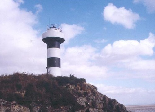
2009(?). Active; focal plane 11 m (36 ft); three white flashes every 6 s. 10 m (30 ft) round cylindrical concrete tower with gallery, mounted on a concrete pier and painted with black and white horizontal bands. No photo available but Bing has a satellite view. Qiáoliángshān is a small island just off the northwestern tip of Qúshāndǎo. Located off the eastern end of the island. Accessible only by boat. Site open, tower closed. CN-2328.535; Admiralty P3718.8275.
Shuǐtǒngjiāo
Date unknown. Active; focal plane 9.5 m (31 ft); flashing white light, period unknown. 7.5 m (25 ft) round white concrete tower. No photo available but Bing has a satellite view. Located on a reef northwest of Qiáoliángshān. Accessible only by boat. Site open, tower closed. CN-2328.53; Admiralty P3718.827.
Xiǎoqúshān
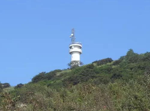
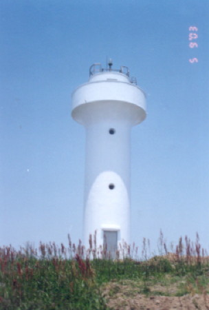
2006(?). Active; focal plane 160 m (525 ft); four white flashes every 15 s. 19 m (62 ft) round cylindrical concrete tower with two galleries. Radar and communications towers are also mounted atop the lighthouse. A photo is at right and Google has a satellite view. According to MSA this lighthouse is staffed by a crew of seven. Xiǎoqúshān (Little Qúshān) is a high island about 5 km (3 mi) northwest of Qúshāndǎo. Located atop the high ridge at the north end of the island. Site status unknown. CN-2328.5; Admiralty P3718.81; NGA 18892.45.
Xiǎohénglēishān (Xiǎohénglēi Shan)
2006(?). Active; focal plane 9 m (30 ft); white flash every 3 s. 8 m (26 ft) round cylindrical concrete tower, painted with red and white horizontal bands. No photo available but Bing has a satellite view. Xiǎohénglēishān is a small island between Huángzéshān and Xiǎoqúshān. Located at the east end of the island. Accessible only by boat. Site status unknown. CN-2328.515; Admiralty P3718.8255.
Huángzéshān (Huangzhe Shan)
2005(?). Active; focal plane 35 m (115 ft); two white flashes every 6 s. 14 m (46 ft) round cylindrical concrete tower, painted with red and white horizontal bands. No photo available but Bing has a satellite view. Huángzéshān is an island about 6 km (3.5 mi) north of Qúshāndǎo. Located on the northern point of the island. Site status unknown. CN-2332.001; Admiralty P3718.84; NGA 18892.4.
Hǎihǔjiāo
Date unknown. Active; focal plane 12 m (39 ft); white flash every 2 s. 11 m (36 ft) round cylindrical white conctere tower. No photo available but Bing has a satellite view. Located on Hǎihǔjiāo (Sea Tiger Reef), a dangerous reef off the east coast of Huángzéshān. Accessible only by boat. Site status unknown. CN-2332.005; Admiralty P3718.838.

Xiǎoqúshān Light, Qúshāndǎo
PRC MSA East China Sea Navigation Center photo
Xiàhǎishān (Xiàhǎi Shan)
2005(?). Active; focal plane 30 m (98 ft); three white flashes every 10 s. 14 m (46 ft) round cylindrical white concrete tower. No photo available but Google has a satellite view. Located on a small island about 4 km (2.5 mi) northeast of Qúshāndǎo. Accessible only by boat. Site status unknown. CN-2332.003; Admiralty P3734.8; NGA 18892.7.
Xiǎopánshān (Xiǎopán Shan)
2006(?). Active; focal plane 9 m (30 ft); white flash every 6 s. 8 m (26 ft) round cylindrical concrete tower, painted with black and white horizontal bands. No photo available but Google has an indistinct satellite view. Located on an island off the eastern end of Qúshāndǎo. Accessible only by boat. Site status unknown. CN-2333.2; Admiralty P3735.5.
Wàisǎoyèjiāo
2006(?). Active; focal plane 13 m (43 ft); two green flashes every 6 s. 10 m (33 ft) round cylindrical concrete tower, painted with green and white horizontal bands. No photo available but Google has a satellite view. Located on a reef off the eastern end of Qúshāndǎo. Accessible only by boat. Site status unknown. CN-2333.3; Admiralty P3736.
Dàqúdōngnánjiǎo (Dàqúdōngnán Jiǎo)
2006(?). Active; focal plane 13 m (43 ft); three white flashes every 8 s. 12.5 m (41 ft) round cylindrical white concrete tower. No photo available but Bing has a satellite view. Located on the extreme southeastern tip of Qúshāndǎo. Accessible only by boat. Site status unknown. CN-2333.5; Admiralty P3736.2.
Xiǎoshǔlàngshān (Xiǎoshǔlàng Shān)
2006. Active; focal plane 16 m (52 ft); two white flashes every 6s. 8 m (26 ft) round cylindrical white concrete tower, painted with black and white horizontal bands. No photo available and the tower is hard to find in Google's satellite view. Located on an island about 3 km (2 mi) east of the southeastern tip of Qúshāndǎo. Accessible only by boat. Site status unknown. CN-2333.7, Admiralty P3736.5.

Zhōngjiēshān Islands Lighthouses
These islands lie at the eastern end of the same chain that includes Dàishāndǎo and Chángtúshāndǎo. The easternmost islands of the chain are administered by the Pǔtuó District of Zhōushān.

Xiǎoguīshān (Xiǎobǎnshān, Steep Island)
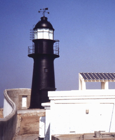
1883. Active; focal plane 75 m (246 ft); two white flashes every 10 s. 11 m (36 ft) round cast iron tower with lantern and gallery, painted black. The MSA photo at right shows the lighthouse after solar power was installed in 2001. Baike.com has another page with a photo and Google has an indistinct satellite view of the station. The lighthouse was damaged in World War II but repaired in 1947. There was a major restoration in 1984. The lighthouse was declared a national cultural monument in 2013. Located atop a small island about 28 km (18 mi) northeast of Zhōushān island. Accessible only by boat, and landing is difficult. Site and tower closed. ARLHS PRC-064; CN-2375; Admiralty P3720; NGA 18904.
Dàmèimèijiāo (Dàmèimèi Jiao, Big Sister Reef)
Date unknown. Active; focal plane 27 m (89 ft); two red flashes every 6 s. 10 m (33 ft) round concrete tower with gallery, colored with red and white horizontal bands. No photo available but Google has a satellite view. Located on a rocky ridge in the passage east of Dōngzhàidǎo. Accessible only by boat. Site status unknown. CN-2374.3; Admiralty P3719.9; NGA 18904.5.
Guāngjiāo (Guāng Jiāo) (2)
Date unknown. Active; focal plane 8 m (26 ft); two white flashes every 6 s. 8 m (26 ft) round white concrete tower. No photo available but Google has a satellite view. NGA lists a skeletal tower at this location. Located on a skerry off the east coast of Dōngzhàidǎo, marking a deep passage between islands in the chain. Accessible only by boat. Site open, tower closed. Admiralty CN-2374.21; P3719.88; NGA 18905.
Dōnggǔzhùjiāo (Dōnggǔzhù Jiāo)
2006. Active; focal plane 10 m (33 ft); white flash every 4 s. 8 m (26 ft) round cylindrical concrete tower with gallery, mounted on a round concrete pier. Lighthouse painted white with one red horizontal band. No photo available but Google has an indistinct satellite view. Located on a rock in the passage west of Dōngzhàidǎo, about 13 km (8 mi) east of Dàchángtúshān. Accessible only by boat. Site open, tower closed. CN-2374.15; Admiralty P3719.82.
Xiaoguishan Light
Xiǎoguīshān Light, Zhōngjiēshān Islands, 2001
PRC MSA Shànghǎi Region photo

Chángtúshān Area Lighthouses
Located just to the east of Dàishāndǎo, Chángtúshān consists of two islands, Dàchángtúshān (Big Chángtúshān) in the east and Xiǎochángtúshān (Little Chángtúshān) in the west. Separated by a narrow channel, the two islands together are about 15 km (9 mi) long from east to west and 4 km (2.5 mi) wide.

Yīngliánshān Northwest (Yīnglián Strait North Entrance)
Date unknown. Active; focal plane 10 m (33 ft); white flash every 6 s. 8.5 m (28 ft) round cylindrical white concrete tower. No photo available but Google has a distant satellite view. Located at the northwestern tip of Yīnglián, marking the north entrance to the passage between that island and Dàchángtúshān. Site status unknown. CN-2373.1; Admiralty P3719.45.
Yīngliánmén Nánkǒu (Yīnglián Strait South Entrance)
Date unknown. Active; focal plane 16 m (52 ft); white flash every 2 s. 13 m (43 ft) round cylindrical white concrete tower. No photo available but Google has a satellite view. Located off the southeastern tip of Dàchángtúshān, marking the south entrance to the passage between that island and Yīnglián. Accessible only by boat. Site status unknown. CN-2373.5; Admiralty P3719.7.
Nánmùzhuāngdǎo (Nánmùzhuāng Dǎo) South
2006. Active; focal plane 11 m (36 ft); two white flashes every 6 s. 9 m (30 ft) round cylindrical concrete tower with gallery, mounted on a round concrete pier. Lighthouse painted white with one red horizontal band. No photo available but Google has a satellite view. Located on an islet off the south end of Nánmùzhuāng island, about 2.5 km (1.5 mi) east of the eastern end of Dàchángtúshān. Accessible only by boat. Site open, tower closed. CN-2373.6, Admiralty P3719.75; NGA 18909.77.
Xiǎojiāobēishān (Xiǎojiāobēi Shān) (2)
1986 (station established 1958). Active; focal plane 18 m (56 ft); white flash every 6 s. 9 m (30 ft) round concrete tower with gallery, covered with white ceramic tile. No closeup photo available but Bing has a satellite view. Located on an isolated reef about 5 km (3 mi) south of Dàchángtúshān. CN-2368; Admiralty P3714.006.
Chángtú Sānkuàishān (Sānkuài Shān) (3)
1992 (station established 1957). Active; focal plane 34 m (112 ft); two white flashes every 6 s. 9 m (30 ft) round concrete tower, covered with white ceramic tile. No closeup photo available but Google has a satellite view. This light guides vessels approaching Chángtúshān from the southwest (from Zhōushān). Located on a small island about 3 km (2 mi) southwest of the southeastern point of Dàishāndǎo and 4 km (2.5 mi) southeast of the southwestern point of Dàchángtúshān. Accessible only by boat. Site open, tower closed. CN-2360, Admiralty P3716.7281.
Chuānbíshānxī (Chuānbí Shān West)
2008. Active; focal plane 19 m (62 ft); nine very quick white flashes every 10 s. 20 m (66 ft) round cylindrical concrete tower, painted yellow with a black horizontal band. No photo available but Google has a satellite view. Located on a reef in the approach to Chángtúshān from the south, about 1.5 km (1mi) south of the Chángtú Fēnshuǐjiāo light (next entry). Accessible only by boat. Site open, tower closed. CN-2365.1, Admiralty P3716.7355.
Chángtú Gǎng Fēnshuǐjiāo (Chángtúshān Fēnshuǐ Jiāo) (3)
1989 (station established 1961). Active; focal plane 12 m (39 ft); four white flashes every 10 s. 10 m (33 ft) round concrete tower with two galleries, covered with white ceramic tile. Google has a satellite view. Not to be confused with the Fēngshuǐjiāo Light off the west end of Dàishāndǎo (see below). Located on a rock in the southwestern entrance to the channel separating the two islands. Accessible only by boat. Site open, tower closed. CN-2363, Admiralty P3716.735.
* Huángníshān (Huángní Shān) (2?)
Date unknown (station established 1956). Active; focal plane 33 m (108 ft); three white flashes every 10 s. The 1997 lighthouse was an 8 m (26 ft) hexagonal cylindrical concrete tower with gallery covered with white ceramic tiles. No current photo available but Bing has a satellite view. Located on Dàchángtúshān at a sharp bend in the channel separating the two islands. Site probably open, tower probably closed. CN-2370.
Xīhèzuǐdǎo (Xīhèzuǐ Dǎo) (3)
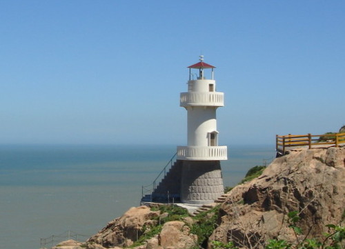
Date unknown (station established 1957). Active; focal plane 44 m (144 ft); white flash every 2 s. 9 m (30 ft) round cylindrical concrete tower with lantern and gallery. Lighthouse painted white; lantern roof is red. A photo is at right and Google has a satellite view. Located atop a small island off the northeastern corner of Xiǎochángtúshān, guiding vessels approaching the channel separating the two islands. Accessible only by boat. Site status unknown. CN-2369, Admiralty P3716.738.
Xihexuidao Light
Xīhèzuǐdǎo Light, Xiǎochángtúshān, July 2006
ex-Panoramio photo copyright 智慧之树; used by permission

Dàishāndǎo Area Lighthouses
Dàishāndǎo (Dàishān Island) is located about 16 km (10 mi) north of Zhoushandǎo in the central part of the Zhōushān archipelago. The island is roughly triangular in shape, about 15 km (9 mi) on each side.

Xiǎozhúyǔ (Xiǎozhú Yǔ)
1994 (station established 1962). Active; focal plane 41 m (135 ft); white flash every 5 s. 8 m (26 ft) hexagonal cylindrical concrete tower with gallery, covered with white ceramic tiles. No photo available but Google has a satellite view. Located atop a small island in the northern entrance to the channel between Dàishāndǎo and Chángtúshāndǎo. Accessible only by boat. Site status unknown. CN-2364, Admiralty P3716.74.
Dàishān Pǔmén Gǎng Dōngkǒu (Dàishān Pǔmén Harbor East Entrance (2)
2003 (station establishment date unknown). Active; focal plane 21 m (62 ft); two white flashes every 6 s. 12 m (39 ft) round cylindrical concrete tower, colored with black and white horizontal bands. MSA's photo is at right and Google has a satellite view. This lighthouse replaced a light on a pyramidal beacon. Located at the southeastern tip of Dàishāndǎo, marking the east entrance to Pumen harbor. Site status unknown. CN-2359, Admiralty P3716.743.
Yādànshān (Yādàn Shān, Yeyadan Shan, Duck Rock)
Date unknown. Active; focal plane 21 m (62 ft); white flash every 6 s.12 m (39 ft) round cylindrical concrete tower with gallery, painted white according to the light lists but green in photos. No photo available but Google has a satellite view. Located on a reef (shaped vaguely like a duck on the water) south of Gāotíng, the principal town of Dàishāndǎo, near the southeastern end of the island. Site open, tower closed. CN-2358, Admiralty P3716.729.
#Guānshān (Guān Shān) (2)
1969 (station established 1953). Replaced. No photo available and Google's satellite view shows that the new Xiùshān Bridge required removing the light. A new light is on a 3 m (10 ft) pole (focal plane 6 m (20 ft); white flash every 4 s, Admiralty P3716.727) was announced in 2016. Located on a reef just off the southern tip of Guānshān, an island south of Dàishān. Accessible only by boat. Site open, tower closed. ex-CN-2356, ex-Admiralty P3716.728.
#Míngjiāo (Míng Jiāo) (2)
1981 (station established 1964). Replaced although still listed by NGA. This was a 16 m (52 ft) hexagonal cylindrical concrete tower with gallery, covered with white ceramic tiles. No photo available. Google's satellite view shows a tower of the Xiùshān Bridge at the listed location, and the light was replaced by a light on the bridge structure. Formerly located on Míngjiāo ("bright reef"), a dangerous reef between the islands of Dàishān and Xiùshān. Site and tower closed. ex-CN-2355; NGA 18909.1; current light: Admiralty P3716.7255.

Dàishān Pumen East Entrance Light, Dàishān
PRC Maritime Safety Administration Shànghǎi Region photo
Dōngshānzuǐ (Dōngshān Zuǐ) (2)
2003 (station established 1953). Active; focal plane 20 m (66 ft); two white flashes every 6 s. 10 m (33 ft) round cylindrical concrete tower with gallery, colored with red and white horizontal bands. No photo available but Google has a satellite view. Located at the east end of a small island about 3 km (2mi) south of Dàishāndǎo and a similar distance north of Xiùshāndǎo. Site status unknown. CN-2350, Admiralty P3716.724.
Nánpǔ Wǔhǔjiāo (Wǔhǔ Jiāo)
Date unknown. Active; focal plane 11 m (36 ft); two white flashes every 5 s. 11 m (36 ft) round concrete tower with gallery, covered with ceramic tile colored black with a red horizontal band. No photo available but Google has a satellite view. Located on a reef just off the south coast of Dàishāndǎo. Accessible only by boat. Site status unknown. CN-2346, Admiralty P3716.707.
Fēngshuǐjiāo (Dàishān Fēngshuǐ Jiāo) (2)
Date unknown. Active; focal plane 10 m (33 ft); flash every 4 s, white or red depending on direction. 10m (33 ft) concrete tower with gallery, painted red. Not to be confused with the Fēnshuǐjiāo light in the Chángtúshān islands (see above). The light is near the right edge in a distant drone view and Google has a satellite view. Located on a rock obstructing the passage around the west end of Dàishāndǎo. Accessible only by boat. Site status unknown. CN-2342, Admiralty P3716.7011.
Huāgǔshān (Huāgǔ Shān) (2)
1996 (station established 1957). Active; focal plane 36 m (118 ft); two white flashes every 6 s. 10 m (33 ft) hexagonal cylindrical concrete tower with gallery, covered with white ceramic tiles. No photo available but Bing has an indistinct satellite view. Located atop a small island about 2.5 km (1.5 mi) off the western tip of Dàishāndǎo. Accessible only by boat. Site status unknown. CN-2341, Admiralty P3716.7; NGA 18908.9.
Yúxīngnǎo (Yúxīngnǎodǎo, Yushingnao, West Volcano Island)
1872. Active; focal plane 27 m (89 ft); two white flashes every 20 s. 10 m (33 ft) round tower with lantern and gallery, painted black. A photo is at right and Bing has a satellite view of the station. Yúxīngnǎo is an isolated islet in the southern part of Hángzhōu Bay, about 15 km (9 mi) northwest of Dàishāndǎo. The lighthouse restored in 2022-23; the photo at right shows the results. Located on the highest point of the island. Accessible only by boat, and landing is difficult. Site and tower closed. ARLHS PRC-074; CN-2337; Admiralty P3716.8; NGA 18908.

Yúxīngnǎo Light, Dàishān, June 2023
Ningbo Maritime Safety Administration photo
Dàzhàizishān (Dàzhài Shān) (3)
Date unknown (station established 1957). Active; focal plane 48 m (157 ft); white flash every 4 s. 8 m (26 ft) round cylindrical concrete tower with gallery, covered with ceramic tiles colored in red and white horizontal bands. No photo available but Google has a satellite view. Located atop a small island about 8 km (5 mi) north northwest of Dàishāndǎo. Accessible only by boat. Site status unknown. CN-2344, Admiralty P3716.77.
Xiǎngpéngshān (Xiǎngpéng Shān) (2)
1993 (station established 1953). Active; focal plane 71 m (233 ft); two white flashes every 6 s. 8 m (26 ft) hexagonal cylindrical concrete tower with gallery, covered with white ceramic tiles. No photo available but Google has a satellite view. Located atop a small island marking the end of an underwater ridge extending from the northern tip of Dàishāndǎo. Accessible only by boat. Site status unknown. CN-2354, Admiralty P3716.76.

Chángtán Islands Lighthouses
The Chángtán Islands include a scattering of small islands at the far western end of Dàishān County, close to the south coast of Hángzhōu Bay.

Dōnghuòshān (Dōnghuò Shān, Tung-ho Shān)
2007. Active; focal plane 55 m (180 ft); two white flashes every 6 s. 8 m (26 ft) round tower with lantern and gallery, painted with red and white horizontal bands. No photo available but Google has a satellite view. This light marks the eastern end of the same reef marked by the Qījiěbāmèi lighthouse. Sibling of the Ménshān Light (see photo above). Located at the eastern end of Dōnghuòshān, an island at the eastern end of the Chángtán Islands about 30 km (19 mi) north of Zhènhǎi. Accessible only by boat. Site status unknown. CN-2337.4; Admiralty P3716.644; NGA 18908.7.
Qījiěbāmèi (Dàchángtán Shān, Tachangtan)
Date unknown. Active; focal plane 39 m (128 ft); white flash every 3 s. 14 m (46 ft) round cylindrical white concrete tower with gallery. An MSA photo is at right and Google has a satellite view. This light marks the west end of a dangerous reef. Located atop the westernmost of the Chángtán Islands, about 32 km (20 mi) north northwest of Zhènhǎi. Accessible only by boat. Site status unknown. CN-2293; Admiralty P3716.64.

Information available on lost lighthouses:

Qizibamei Light
Qījiěbāmèi Light, Chángtán Islands, Cíxī, June 2003
PRC Maritime Safety Administration photo

Notable faux lighthouses:

Adjoining pages: North: Shèngsì Islands | South: Dìnghǎi District

Return to the Lighthouse Directory index | Ratings key

Posted May 12, 2008. Checked and revised October 19, 2023. Lighthouses 48. Site copyright 2023 Russ Rowlett and the University of North Carolina at Chapel Hill.