Lighthouses of China: Shèngsì Islands, Zhèjiāng

The People's Republic of China (中华, Zhōnghuá in Chinese) has a lengthy coastline, many large harbors, and a large number of lighthouses. The country is divided into 23 provinces and 11 other province-level regions of various special types. The province of Zhèjiāng (formerly spelled Chekiang) occupies the central coast of the country, south of Shànghǎi and north of the Formosa Strait. The province faces east on the East China Sea. For the most part the coastline is hilly and irregular, with more than 3000 islands of all sizes offshore.

Hángzhōu Bay is a large embayment at the northern end of the province. Spread across the mouth of Hángzhōu Bay, the Zhōushān Islands include well over 1000 islands, although only 103 are large enough to be inhabited. Lighting this maze of islands requires hundreds of beacons of all sizes. The islands are organized as Zhōushān City, one of the eleven prefectural-level cities of Zhèjiāng Province. This page covers lighthouses of the Shèngsì Islands, the northeasternmost of the Zhōushān Islands. These islands comprise Shèngsì County, one of the four subdivisions of Zhōushān City. China is developing the major deep-water port of Yángshān, a satellite port for Shànghǎi, in the Qíqū Islands in the western end of the Shèngsì archipelago.

Lighthouses in China are maintained by the PRC Maritime Safety Administration. The administration is organized in four regional administrations, with offices in the major ports. All the lights on this page are maintained by the Zhènhǎi MSA office.

There are many languages and dialects spoken in China, but Standard Chinese, often called Mandarin, is official. The pīnyīn system for transliterating Standard Chinese into Latin characters is now the international standard but some locations continue to be known also under the spellings of older transliteration systems. The Chinese word for a lighthouse is dēngtǎ (灯塔). In Standard Chinese jiāo (formerly chiao) is a reef or rock, jiǎo is a cape or headland, dǎo (tao) is an island; (tsu) or tuózi ("lump") is a small island, hǎi is a sea, wān is a bay, hǎixiá is a strait, or jiāng is a river, hékǒu ("river mouth") is an estuary, and gǎng (kang) is a harbor.

ARLHS numbers are from the ARLHS World List of Lights. CN numbers are Chinese light list numbers, where known. Admiralty numbers are from volume P of the Admiralty List of Lights & Fog Signals. U.S. NGA List numbers are from Publication 112.

General Sources
Online List of Lights - China
Photos by various photographers posted by Alexander Trabas.
Zhōushān Lighthouses
Photos of nineteen of the best-known lighthouses of the islands.
Shengsi: Visit the Lighthouses
Photos of lighthouses in the islands.
Chinese English Pinyin Dictionary
A useful tool for juggling the representations of Chinese names.
Navionics Charts
Navigation chart for Zhèjiāng


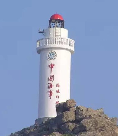
Hǎijiāo Light, Shèngsi
PRC Maritime Safety Administration photo
Hǎijiāo and Lànggǎngshān Islands Lighthouses
These are the most remote of the Shèngsi Islands. Hǎijiāo is an isolated island about 32 km (20 mi) east of the Mǎ'ān group. Zhōngkuídǎo is the largest of the Lànggǎngshān islands, about 30 km (19 mi) southeast of the Mǎ'ān group.
 
Hǎijiāo (2)
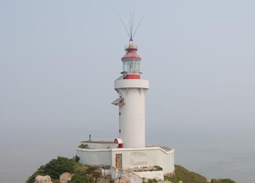
2007 (station established 1977). Active; focal plane 58 m (190 ft); white flash every 6 s. 12.5 m (41 ft) round cylindrical concrete tower with lantern and gallery, painted white; lantern dome painted red. An MSA photo is at the top of this page and Bing has an indistinct satellite view. In 1997 the original lighthouse was repaired after being damaged by a typhoon. This is the easternmost Chinese lighthouse. Located atop an isolated rocky pinnacle far out in the East China Sea, about 100 km (60 mi) east of Cape Yangtze and 50 km (30 mi) east of Huāniǎo Shān. (Hǎijiāo means "sea reef.") Accessible only by boat, and landing is difficult. Site and tower closed. CN-2294; Admiralty P3747.4; NGA 18864.
Zhōngkuídǎo (Langgang Shan, Zhongkui, Lukon Island)
1988. Active; focal plane 107 m (351 ft); four white flashes every 10 s. 15 m (49 ft) round white concrete tower. No photo available but Bing has a satellite view. Zhongkuidǎo is an highest of a small group of islands in the East China Sea about 50 km (30 mi) east of Qúshāndǎo. Located on the highest point of the island. Accessible only by boat. Site and tower closed. CN-2336.1; Admiralty P3730; NGA 18902.

Mǎ'ān Islands Lighthouses
The Mǎ'ān or Saddle Islands are at the far northeastern end of the Zhōushān archipelago.

*
Huāniǎoshān (Huāniǎo Shān, North Saddle Island)
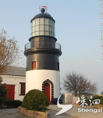
1870. Active; focal plane 89 m (292 ft); white flash every 15 s. 16.5 m (54 ft) round brick tower with lantern and gallery. Lighthouse painted black with a white horizontal band at the base. Fog siren (five blasts every 60 s). This is a staffed station. A photo is at right and Google has a satellite view of the station. Huāniǎo Shān ("Flower and Bird Mountain") is the northernmost of the Mǎ'ān Islands, about 130 km (80 mi) southeast of Shànghǎi. The lighthouse, an important navigational aid for vessels arriving in Shànghǎi from the south, was listed by the provincial government as a cultural monument in 1997. There is ferry transportation to the island, and the lighthouse is accessible by road. Located on the northern tip of the island. Site open, tower closed. ARLHS PRC-033; CN-2295; Admiralty P3746; NGA 18872.
Huaniaoshan Light
Huāniǎoshān Light, Mǎ'ān Islands
Shèngsì County Media Bureau photo
Xiǎodǎojiùyǔ
Date unknown. Active; focal plane 26.5 m (87 ft); three white flashes every 10 s. Approx. 6 m (20 ft) white concrete tower. Nick Freeman has a distant drone view and Google has a satellite view. Located atop an islet off the northeast corner of Gǒuqǐ (Wolfberry) Island, one of two inhabited islands at the southeast end of the Mǎ'ān group. Site status unknown. CN-2303; Admiralty P3747.2.
Zhōngshānjiāo
Date unknown. Active; focal plane 13.5 m (45 ft); two white flashes every 5 s. 13 m (43 ft) concrete tower painted black with one red horizontal band, mounted on a large round pier. Ji Kware has a very distant view (the lighthouse is to the left of the ship) and Google has a satellite view. Located on a shoal northwest of the harbor of Mányútóudǎo. Accessible only by boat. Site open, tower closed. CN-2303.1; Admiralty P3747.17.
* Mányútóudǎo (Mányútóu Dǎo) (2)
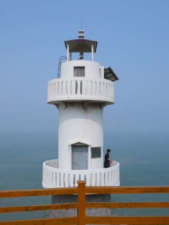
Date unknown. Active; focal plane 52 m (171 ft); flash every 12 s, white or red depending on direction. 7 m (23 ft) round cylindrical white concrete tower with gallery. Jin Yul has a closeup photo (also seen at right) and Google has a street view and an indistinct satellite view. NGA lists a 3 m (10 ft) square stone tower. Mányútóudǎo (Eelhead Island) is at the southeastern end of the Mǎ'ān group, and the lighthouse is on a promontory on the southeastern peninsula of the island. Site open, tower closed. CN-2305; Admiralty P3747.3; NGA 18876.9.
Xiǎogōngjiāo (Xiǎogōngshān, Xiǎogōng Jiāo)
Date unknown. Active; focal plane 27 m (89 ft); green flash every 4 s. 7 m (23 ft) round concrete tower, colored with green and white horizontal bands. No photo available but Bing has a distant satellite view. Located on one of the southernmost islets of the Mǎ'ān Islands. Accessible only by boat. Site open, tower closed. CN-2305.01; Admiralty P3747.28; NGA 18876.3.
Ménqiánjiāo
Date unknown. Active; focal plane 14.5 m (48 ft); two white flashes every 6 s. 12 m (39 ft) round cylindrical concrete tower colored with black and white horizonal bands. Google has an indistinct satellite view. Located on the southernmost islet of the Mǎ'ān Islands. Accessible only by boat. Site open, tower closed. CN-2305.03; Admiralty M3747.26; NGA 18876.7.
Huángshídōngjiāo (Huángshídōng Jiāo)
Date unknown. Active; focal plane 31 m (102 ft); white flash every 4 s. 7 m (23 ft) round white concrete tower. No photo available but Google has an indistinct satellite view and the light is just barely visible atop the smaller island in Cabala Feng's photo. Located on the southwesternmost islet of the Mǎ'ān Islands. Accessible only by boat. Site open, tower closed. CN-2305.02; Admiralty P3747.14; NGA 18876.2.
Péngjiāo (Péng Jiāo)
Date unknown. Active; focal plane 16 m (52 ft); three white flashes every 12 s. 7 m (23 ft) round white concrete tower. No photo available but Bing has a distant satellite view. Located on on a tiny islet on the west side of the Mǎ'ān Islands. Accessible only by boat. Site open, tower closed. CN-2305.1; Admiralty P3747.125.

Mányútóudǎo Light, Mǎ'ān Islands
Google Maps photo by Jin Yul
Dōngkùshān (Dōngkù Shān)
Date unknown. Active; focal plane 21 m (69 m); two white flashes every 6 s. 7 m (23 ft) round cylindrical cancrete tower painted with black and white horizontal bands. No photo available but Bing has a distant satellite view. Located at the northern tip of Dōngkùshān, one of the islands in the group at the western extremity of the Mǎ'ān Islands. Accessible only by boat. Site open, tower closed. CN-2297.2; Admiralty P3747.08.
Guòlàngzuǐtóu
Date unknown. Active; focal plane 25 m (82 m); white flash every 2 s. 7 m (23 ft) round cylindrical cancrete tower painted with black and white horizontal bands. No photo available but Bing has a distant satellite view. Located at the east end of an island group at the western extremity of the Mǎ'ān Islands. Accessible only by boat. Site open, tower closed. CN-2297.1; Admiralty P3747.07.
Mántóushān (Mántóu Shān)
Date unknown. Active; focal plane 27 m (89 ft); white flash every 6 s. 10 m (33 ft) round cylindrical white concrete tower with gallery. No photo available but Google has a satellite view. Located at the south end of an island at the western extremity of the Mǎ'ān Islands. Accessible only by boat. Site open, tower closed. CN-2298.1; Admiralty P3747.05; NGA 18876.1.
Xībànyángjiāo
Date unknown. Active; focal plane 19.5 m (65 ft); two white flashes every 5 s. 10 m (33 ft) hexagonal cylindrical concrete tower colored with red and white horizontal bands. No photo available but Bing has a satellite view. Located on a reef halfway between the Mǎ'ān Islands and Sìjiāo. Accessible only by boat. Site open, tower closed. CN-2305.2; Admiralty P3747.13; NGA 18876.5.

Sìjiāo Area Lighthouses
Sìjiāoshān (Sìjiāo Island) is the largest of the Shèngsì islands and a popular destination for Chinese tourists; there is daily ferry service from Shànghǎi.

Wàimǎlángshān (Wàimǎláng Shān) (3)
1996 (station established 1952). Active; focal plane 69 m (226 ft); white flash every 6 s. 10 m (33 ft) hexagonal cylindrical concrete tower with gallery, covered with white tiles. No photo available but Google has a satellite view. Located on a small island about 2.5 km (1.5 mi) off the south coast of Sìjiāo. CN-2316; Admiralty P3740.03.
Nèimǎtíjāo (Inner Horseshoe Reef)
Date unknown. Active; focal plane 11 m (36 ft); white flash every 1.5 s. 7.5 m (25 ft) round tower, painted white. No photo available but Google has a satellite view. Located on a reef off the southern coast of Sìjiāo. Accessible only by boat. Site status unknown. CN-2315.2; Admiralty P3740.025; NGA 18878.5.
Wàimǎtíjāo (Outer Horseshoe Reef)
Date unknown. Active; focal plane 15 m (49 ft); two white flashes every 8 s. 11 m (36 ft) round cylindrical white concrete tower. No photo available but Google has a satellite view. Located on a reef about 800 m (1/2 mi) south of the Nèimǎtí Light. Accessible only by boat. Site status unknown. CN-2315.25; Admiralty P3740.027; NGA 18878.2.
Tiāoliú Breakwater
Date unknown. Active; focal plane 11 m (36 ft); yellow light, 2 s on, 2 s off. 10 m (33 ft) round concrete tower, colored with red and white horizontal bands. No photo available but Google has a satellite view. Located on the north breakwater of a harbor on the south side of Mǎjìshān, a small island just off the southwestern tip of Sìjiāo. Site and tower closed (industrial area). CN-2315.23; Admiralty P3740.021.
Mǎpìgǔ (Mǎjìshān, Ma-chi Shān)
Date unknown. Active; focal plane 128 m (420 ft); three white flashes every 10 s. 16 m (52 ft) round tower, painted white with narrow red horizontal bands. No photo available but Google has a satellite view. Located on the highest point of Mǎjìshān. Accessible only by boat. Site status unknown. CN-2315.1; Admiralty P3740.02; NGA 18878.
Niu'ējiāo (Niu'ē Jiāo) (2)
Date unknown. Active; focal plane 19.5 m (64 ft); white flash every 6 s. 10 m (33 ft) round cylindrical white concrete tower with gallery. No photo available but Bing has a satellite view. The earlier pyramidal tower was still present as of 2006. Located on an isolated reef about 8 km (5 mi) west southwest of the northwestern point of Sìjiāo. Accessible only by boat. Site and tower closed. CN-2311; Admiralty P3740.5.
Cǎoxiépàjiāo (Cǎoxiépà Jiāo, Nanlong Jiāo) (2?)
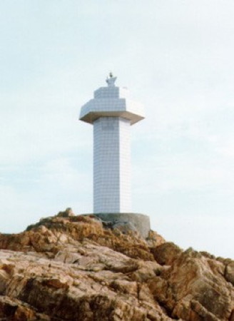
1996 (station established 1957). Active; focal plane 20 m (66 ft); two white flashes every 6 s. 10 m (33 ft) hexagonal cylindrical concrete tower with gallery, covered with white tiles. MSA's photo is at right and Google has a satellite view. Located about 2 km (1.25 mi) off the northwestern point of Sìjiāo. Accessible only by boat. Site and tower closed. CN-2309; Admiralty P3740.7.
Caoxiepajiao Light
Cǎoxiépàjiāo Light, Sìjiāo
PRC Maritime Safety Administration photo
Biàndànjiāo (Biàndàn Jiāo) (Dàmáofēng Dǎo)
2004. Active; focal plane 9 m (30 ft); flash every 3 s, white or red depending on direction. 8 m (26 ft) white concrete tower. No photo available but Google has an indistinct satellite view. Located at the north end of Dàmáofēng Island about 1.2 km (3/4 mi) southwest of Hǔyújiāo. Site status unknown. CN-2307; Admiralty P3740.8; NGA 18877.5.
Hǔyújiāo (Hǔyú Jiāo, Tigerfish Reef)
Date unknown. Active; focal plane 10 m (33 ft); four white flashes every 10 s. 10 m (33 ft) hexagonal skeletal tower with gallery, painted white, mounted on a round concrete pier. No photo available but Google has a satellite view. Located on a reef about 800 m (1/2 mi) west of the Lǐsìjiāo lighthouse. Accessible only by boat. Site and tower closed. CN-2306.1; Admiralty P3740.9; NGA 18877.3.
Lǐsìjiāo (Lǐsì Jiāo)
1955. Active; focal plane 38 m (125 ft); three white flashes every 10 s. 8 m (28 ft) square masonry tower with gallery, covered with white ceramic tiles. No photo available but Google has an indistinct satellite view. Lǐsìjiāo is a reef about 5 km (3 mi) north northeast of the northern point of Sìjiāo. Located atop the reef. Accessible only by boat, and landing is difficult. Site and tower closed. CN-2306; Admiralty P3741; NGA 18877.
Luāndāoshān (Luāndāo Shān)
2007. Active; focal plane 38 m (125 ft); quick-flashing white light. 9 m (30 ft) round concrete tower with lantern and gallery, painted white with red trim, including four narrow red vertical stripes. No photo available but Google has an indistinct satellite view. Located on a small island about 7 km (4 mi) northeast of the northern point of Sìjiāo. Accessible only by boat. Site and tower closed. CN-2306.2; Admiralty P3740.95.
Wàijiāo (Wài Jiāo, Shèngsì Wàijiāo) (2)
Date unknown. Active; focal plane 19 m (62 ft); white flash every 6 s. 12 m (39 ft) round concrete tower with lantern and gallery, mounted on a round concrete pier. Lighthouse painted white, lantern red. No photo available but Bing has a very distant satellite view. Located on an isolated reef about 15 km (9 mi) northeast of Sìjiāo. Accessible only by boat. Site and tower closed. CN-2308; Admiralty P3744.
Xiǎocàiyuán
Date unknown. Inactive since 2010. This was an approx. 12 m (93 ft) round tower with a flared top, colored with red and white horizontal bands. Jie Wan has a 2018 view across the harbor and Google has a satellite view. In January 2010 Shànghǎi MSA issued a notice to mariners mentioning the "removal" of this light but the tower was not removed. Located at the end of a 1.25 km (0.8 mi) long breakwater that extends southward from Jinping, a small island northwest of Sìjiāo; this breakwater creates a large protected harbor on the north side of Sìjiāo. Site status unknown. ex-CN-2312; ex-Admiralty P3742.
* Běicháoyángshān (Huìchéng, Weicheng) (3)
2006 (station established 1952). Active; focal plane 65 m (213 ft); two flashes every 6 s, white, red or green depending on direction. Approx. 12 m (39 ft) round cylindrical concrete tower with lantern and gallery. Lighthouse painted white, lantern roof black. A photo is at right, Rochelle Ran has a nice sunrise photo, a 2017 closeup is available, Tony Feng has a 2018 street view, and Google has a satellite view. This lighthouse replaced a 1984 lighthouse shown in an MSA photo no longer online. The light guides vessels approaching Huìchéng. Located at the eastern tip of Sìjiāo. Site open, tower closed. CN-2313; Admiralty P3743.
Weicheng Light
Běicháoyángshān Light, Sìjiāo, May 2008
Flickr Creative Commons photo by Christopher

Dàhuánglóng Shān Lighthouses
Dàhuánglóng Shān is an inhabited island about 5 km (3 mi) southeast of Sìjiāo.
* Dàqiánzuǐ Tóu (2)
1967 (station established 1957). Active; focal plane 35 m (115 ft); three white flashes every 10 s. 8.5 m (28 ft) hexagonal cylindrical concrete tower with gallery, covered with white ceramic tiles. Jia Zhou has a distant view (lighthouse at lower left) and Google has a satellite view. Located at the northern tip of Dàhuánglóng Shān. MSA says the lighthouse is accessible by a hiking trail. Site open, tower closed. CN-2314; Admiralty P3740.08; NGA 18879.
Dàhuánglóng
Date unknown. Active; focal plane 91 m (299 ft); white flash every 4 s. 16 m (52 ft) round tower, painted with red and white horizontal bands. No photo available but Google has a satellite view. Located at the easternmost point of Dàhuánglóng Shān. Accessible only by boat. Site status unknown. CN-2316.1; Admiralty P3740.06; NGA 18879.1.

Bái Jiéxià Strait (Bonham Strait) Lighthouses
The Bái Jiéxià Strait (known to Western navigators historically as the Bonham Strait) is an important entrance to the Hángzhōu gulf passing the south side of Huanglong Shān and Sìjiāo.

Nándǐngxīng (Nantinghsing)
Date unknown. Active; focal plane 129 m (423 ft); three white flashes, in a 2+1 pattern, every 9 s. 16 m (52 ft) round cylindrical tower covered with tiles colored in red and white horizontal bands. No photo available but Bing has a satellite view. Nándǐngxīng is a small island southwest of Dàhuánglóng Shān. Located on the highest point of the island. Accessible only by boat. Site status unknown. CN-2318.1; Admiralty P3740.055; NGA 18879.5.
Xiǎobànbiānshān (Hsiao-pan-pien) Shān
Date unknown. Active; focal plane 72 m (236 ft); two white flashes every 6 s. 16 m (52 ft) round tower, painted with red and white horizontal bands. No photo available but Google has a satellite view. Xiǎobànbiān Shān (Little Half Mountain) is a rocky pinnacle about 5 km (3 mi) east of Bái Jiéxià Shān. Located on the highest point of the islet. Accessible only by boat. Site status unknown. CN-2318.4; Admiralty P3739; NGA 18879.6.
Báijiéshān (Pai-Chieh Shān, Bonham Island)
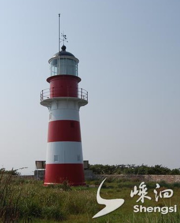
1883. Active; focal plane 75 m (246 ft); flash every 30 s, alternately red and white. 14.5 m (47 ft) round cast iron (?) tower with lantern and gallery. Lighthouse painted with red and white horizontal bands. This is a staffed station. A photo is at right, another photo and aerial view (halfway down the page) are available, and Google has a satellite view. Báijiéshān is a small island in the western portion of the Bái Jiéxià Strait (Bonham Strait). Located at the highest point of the island. Accessible only by boat. Site and tower closed. ARLHS PRC-003; CN-2320; Admiralty P3738; NGA 18884.

Baijieshan Light
Báijiéshān Light, Bái Jiéxià Strait
Shèngsì County Media Bureau photo

Bànyángjiāo (Bànyángshān, Panyangshan, Button Reef)
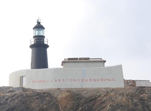
1904. Active; focal plane 19 m (62 ft); white flash every 3 s. 10 m (33 ft) round concrete tower with lantern and gallery, mounted on a white concrete pier. Lighthouse painted black. This is a staffed station. A photo is at right and Google has an indistinct satellite view of the station. Bànyáng is a dangerous reef in the Bái Jiéxià Strait (Bonham Strait). Located about 15 km (9 mi) southwest of the southwestern tip of Huāniǎo Shān. Accessible only by boat, and landing is difficult. Site and tower closed. CN-2319; Admiralty P3740; NGA 18880.

Xúgōngdǎo Area Lighthouse
Xúgōngdǎo is an island about 20 km (13 mi) southwest of Sìjiāo.

Lóngjiāo (Lóng Jiāo)
Date unknown. Active; focal plane 16 m (52 ft); two white flashes every 8 s. 11 m (36 ft) round cylindrical concrete tower colored with black and white horizontal bands. No photo available but Google has a satellite view. Located on an islet off the southeast coast of Xúgōngdǎo. Accessible only by boat. Site open, tower closed. CN-2320.3; Admiralty P3718.895.
Xúgōngdǎo (Xúgōng Dǎo)
Date unknown. Active; focal plane 29 m (95 ft); four white flashes every 10 s. 10 m (33 ft) round white concrete tower with gallery. No photo available but Google has a satellite view. Located on an islet off the south end of Xúgōngdǎo. Accessible only by boat. Site open, tower closed. CN-2323.1; Admiralty P3718.89; NGA 18892.48.

Bànyángjiāo Light, Bái Jiéxià Strait
Shèngsì County Media Bureau photo

Dàjíshān Island Lighthouse
Dàjíshān (Ta-chi Shān, Gutzlaff Island) (4)
1994 (station established 1869). Active; focal plane 92 m (302 ft); two white flashes every 10 s. 24 m (79 ft) octagonal cylindrical tower with lantern and a square vessel traffic control room. The lighthouse is covered with white ceramic tile; lantern dome painted red. This is a staffed coast guard and vessel traffic control station. This lighthouse marks the northern entrance to Hángzhōu Bay. The original lighthouse, a round cast iron tower, was replaced in 1900 by another round 13 m (43 ft) cast iron tower. Probably that tower was damaged or destroyed in World War II, so a brick tower was built in 1958. An MSA photo is at right and Google has a satellite view of the station. Located atop an isolated rocky islet about 25 km (15 mi) east southeast of Nanhuijiao (Cape Yangtze) and 30 km (19 mi) west northwest of Sìjiāo. CN-2322; Admiralty P3748; NGA 18868.

Qíqū Islands (Yángshān Area) Lighthouses
The Qíqū Islands (Qíqū Lièdǎo) lie in the northern part of Hángzhōu Bay about 40 km (25 mi) southwest of Sìjiāo and a similar distance southeast of the mainland. They are administered as part of Shèngsì County. In order to provide better deep-water port facilities for Shànghǎi, construction began in 2001 for a major port facility in the Qíqū Islands capable of berthing the world's largest ships. This port, Yángshān, is connected to the mainland by the 32.5 km (20.2 mi) long Dōnghǎi Bridge, completed in 2005. In 2014 Shànghǎi authorities announced plans to build a second bridge incorporating road and rail.

Xiǎojíshān (Xiǎo Jíshān)
Date unknown. Active; focal plane 51.5 m (169 ft); two white flashes every 8 s. 8 m (26 ft) round white metal tower. No photo available but Google has an indistinct satellite view. Located atop a small island at the northern end of the Qíqū Islands. Accessible only by boat. Site status unknown. CN-2322.01; Admiralty P3747.6; NGA 18867.
Bodāozuǐdǎo (Bodāozuǐ Dǎo)
Date unknown. Active; focal plane 61.5 m (202 ft); two white flashes every 6 s. 4 m (13 ft) round white stone tower. No photo available but Bing has a very distant satellite view. Located at the east end of an island at the eastern end of the Qíqū Islands. Accessible only by boat. Site status unknown. CN-2326; Admiralty P3717.7.
Dajishan Light
Dàjíshān Light, Dàjíshāndǎo
PRC Maritime Safety Administration photo
Hǔxiàoshédǎo (Hǔxiàoshé Dǎo)
2006. Active; focal plane 41 m (135 ft); white flash every 4 s. 14 m (46 ft) round cylindrical white concrete tower with gallery. No photo available but Google has a satellite view. Located on a small island at the east end of the Qíqū group, about 2.5 km (1.5 mi) east of Shaojidǎo. Site status unknown. CN-2326.5; Admiralty P3717.78; NGA 18892.32.
Xīmǎ'āndǎo (Xīmǎ'ān Dǎo, Xīmǎ'ānshān Dǎo)
2006. Active; focal plane 99 m (325 ft); white flash every 5 s. 18 m (59 ft) round cylindrical white concrete tower with lantern and gallery. Lighthouse painted white, lantern red. A closeup photo is at right and Google has a good satellite view. This light serves as a landfall lighthouse for the port of Yángshān. Located atop the small island of Xīmǎ'āndǎo ("West Ma'an Island") about 3 km (2 mi) southeast of Shāojīdǎo and the same distance southwest of Hǔxiàoshédǎo. Accessible only by boat. Site status unknown. CN-2328; Admiralty P3717.8.
Xīmǎ'āndǎo North (Xīmǎ'ān Dǎo North)
Date unknown. Active; focal plane 26 m (85 ft); white flash every 4 s. 10.5 m (34 ft) round white metal tower. No photo available but Google has an indistinct satellite view. Located on the northern tip of Xīmǎ'āndǎo. Accessible only by boat. Site status unknown. CN-2328.01; Admiralty P3717.79; NGA 18892.34.
Shāojīdǎo (Shaoji Dǎo)
2006. Active; focal plane 35 m (115 ft); two white flashes every 6 s. 12 m (39 ft) round cylindrical white concrete tower with gallery and an open lantern. No photo available but Google has a satellite view. Located at the south end of Shāojīdǎo, an island near the east end of Qíqū group. Site status unknown. CN-2326.3; Admiralty P3717.74; NGA 18892.31.
Gōngshān (Qíqū Liedǎo, Gōng Shān)
2005. Active; focal plane 100 m (328 ft); white flash every 10 s. Tall steel tower topped by a round structure with gallery carrying a radar antenna. The lighthouse is silvery metallic. Gāo Xiāngqí has a very distant view and Google has a satellite view. Located atop a steep rocky island on the south side of Yángshān. Site status unknown, probably closed. CN-2325.1; Admiralty P3717.754; NGA 18892.3.

Xīmǎ'āndǎo Light, Qíqū Islands
PRC Maritime Safety Administration photo
Tángnǎoshān (Southwest Horn) (3)
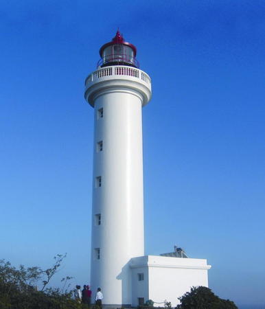
1996 (station established 1907). Active; focal plane 41 m (135 ft); three white flashes every 10 s. 23 m (75 ft) round cylindrical concrete tower with lantern and gallery, centered on a 1-story concrete keeper's cottage. Lighthouse painted white, lantern red. A photo is at right, additional photos (halfway down the page) are available, and Google has a good satellite view. The original lighthouse had a lantern mounted on the roof of a keeper's cottage; it was replaced in 1990 by a similar but larger structure. Tángnǎoshān is an isolated rock in Hángzhōu Bay at the western end of the Qíqū group. Accessible only by boat, and landing is difficult. Site and tower closed. CN-2324; Admiralty P3717; NGA 18892.
Xiǎowūguī (Ziaowugui) (2)
1969 (station established 1955). Inactive since 2018. 11 m (36 ft) round concrete tower with gallery, covered with ceramic tiles in black and white horizontal bands. No photo available but Google has a satellite view. Located on a rock in Hángzhōu Bay just west of the southern end of the main span of the Dōnghǎi Bridge and about 8 km (5 mi) northeast of the Tángnǎoshān lighthouse. Accessible only by boat, and landing is difficult. Site and tower closed. ex-CN-2323; ex-Admiralty P3717.5; NGA 18888.

Tānhǔxiāng Islands Lighthouses
This is a group of small islands near the centerline of the bay west of the Qíqū Islands.

Duìkǒushān
Date unknown. Active; focal plane 28 m (92 ft); white flash every 6 s. 5 m (17 ft) round cylindrical white concrete tower. No photo available but Google has a satellite view. Located on a small island at the southeastern end of the group. Accessible only by boat. Site status unknown. CN-2261; Admiralty P3718.1.
Tangnaoshan Light
Tángnǎoshān Light, Qíqū Islands
Shèngsì County Media Bureau photo
Tānhǔshān (Tanxu Shan)
Date unknown. Active; focal plane 77 m (253 ft); two white flashes every 10 s. 5 m (17 ft) round cylindrical white (?) concrete tower. No photo available but Google has a satellite view. Located on the ridge above Tānhǔxiāng, the only settlement in the group. Accessible only by boat. Site status unknown. CN-2262; Admiralty P3718.2.

Information available on lost lighthouses:

Notable faux lighthouses:

Adjoining pages: North: Shànghǎi | South: Daishān Islands | Northwest: Jiāxīing and Níngbō

Return to the Lighthouse Directory index | Ratings key

Posted May 12, 2008. Checked and revised October 12, 2023. Lighthouses: 48. Site copyright 2023 Russ Rowlett and the University of North Carolina at Chapel Hill.