Lighthouses of China: Níngdé, Fújiàn

China, officially Zhōngguó (中华), has been the largest and most dominant nation of East Asia since it was unified under a single emporer in 221 BCE. However imperial power waned during the nineteenth century, allowing European colonial powers to enter the country. Britain, France, Portugal, Germany, and Russia all established outposts in China. European engineers developed Chinese ports and built the first Western lighthouses, many of which remain in service today. After the imperial government was overthrown in 1912 China entered a long period of instability. The civil war between republican and Communist forces began in 1927. In 1937 Japan invaded, occupying large parts of China and starting a war that merged with World War II. After that war ended in 1945 civil war resumed and by 1949 the Communists achieved control of the entire mainland, the republicans retreating to the island of Taiwan.

Today the People's Republic of China (PRC) has a lengthy coastline, many large harbors, and a large number of lighthouses. The country is divided into 22 provinces and 11 other province-level regions of various special types. The province of Fújiàn (formerly spelled Fukien or Fuchien) is located on the southeastern coast of the country facing Taiwan across the Taiwan Strait. The coastline is rugged and irregular with many islands and reefs threatening unwary navigators. Many bays cut deeply into the mainland; Sānshā Bay is the largest of these embayments.

Fújiàn is divided into nine prefectural-level cities, six of them facing the coast. This page includes lighthouses of the prefectural level city of Níngdé in the northern part of the province adjacent to Zhèjiāng.

There are many languages and dialects spoken in China, but Standard Chinese, often called Mandarin, is official. The pīnyīn system for transliterating Standard Chinese into Latin characters is now the international standard but some locations continue to be known also under the spellings of older transliteration systems. The Chinese word for a lighthouse is dēngtǎ (灯塔). In Standard Chinese jiāo (formerly chiao) is a reef or rock, jiǎo is a cape or headland, dǎo (tao) is an island; (tsu) or tuózi ("lump") is a small island, hǎi is a sea, wān is a bay, hǎixiá is a strait, or jiāng is a river, hékǒu ("river mouth") is an estuary, and gǎng (kang) is a harbor.

Lighthouses in China are maintained by the PRC Maritime Safety Administration. The administration is organized in four regional administrations with district offices in the major ports. All the lights on this page are maintained by the Fúzhōu MSA office, which is part of the Shànghǎi Region.

ARLHS numbers are from the ARLHS World List of Lights. CN numbers are the MSA List of Lights (助航标志表) numbers. Admiralty numbers are from volume P of the Admiralty List of Lights & Fog Signals. U.S. NGA List numbers are from Publication 112.

General Sources
Online List of Lights - China
Photos by various photographers posted by Alexander Trabas.
Chinese English Pinyin Dictionary
A useful tool for juggling the representations of Chinese names.
Navionics Charts
Navigational chart for Fújiàn.


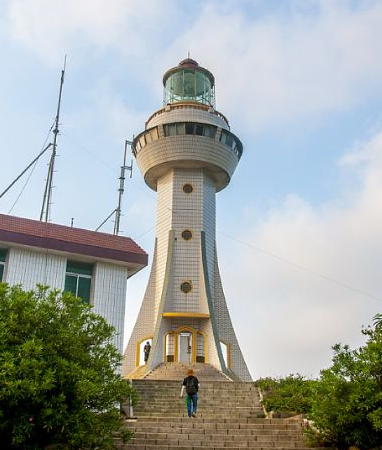
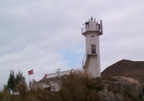
Xītáishān Light, Táishān Islands, Fúdǐng County, September 2019
unattributed Sohu.com photo (no longer online)
Fúdǐng Lighthouses

Fúdǐng is a county-level city with a population of about 300,000. Shāchéng is the only important port in the city.

Táishān Islands Lighthouse
Xītáishān (West Táishān Island) (2)
1992 (station establishment date unknown). Active; focal plane 144 m (472 ft); white flash every 4 s. 24.5 m (80 ft) tower with lantern, six sweeping buttresses, and a circular observation room under the lantern. Lighthouse covered with white ceramic tile; lantern roof painted red. A photo is above and Google has a satellite view. The Táishān Islands are located about 30 km (19 mi) off the mainland precisely on the border between Zhèjiāng and Fújiàn provinces. Prior to 1950 the islands were part of Zhèjiāng but recent maps show that they are now in Fújiàn. Located at the highest point of Xītáishān (West Táishān). Accessible only by boat. Site status unknown. ARLHS PRC-068; CN-2861; Admiralty P3648; NGA 19087.

Shāchéng Bay Area Lighthouses
Lóngmùjiāo ("Dragon's Eye Reef)
Date unknown. Active; focal plane 9 m (30 ft); white flash every 3 s. 12 m (39 ft) black concrete tower. No photo available but Google has a satellite view. Located on a shoal off Shāchéngzhèn, a peninsula opposite Fújiàn Head. Accessible only by boat. Site status unknown. CN-2837; Admiralty P3648.08.
Liánhuā Yǔ (Lotus Islet) (2)
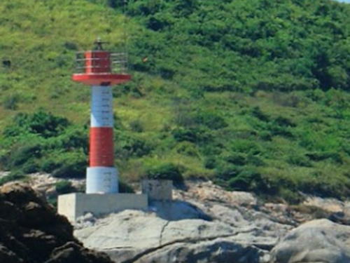
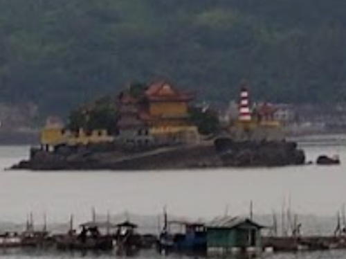
2003 (station established 1955). Active; focal plane 16.5 m (54 ft); three white flashes every 10 s. 10.5 m (34 ft) tapered round fiberglass tower, colored in red and white horizontal bands. 2-story keeper's house with a tile roof. Chen Huang has a distant photo (a protion is seen at right) and Google has a satellite view. The original lighthouse was a white masonry tower. This interesting and probably historic light station is located on a tiny islet in the center of the Shāchéng estuary, about 7 km (4.5 mi) northwest of the Fújiàn Head light. Accessible only by boat. Site and tower closed. CN-2838; Admiralty P3648.1.
Fújiàn Tóu (Fújiàn Head) (2)
1996. Active; focal plane 53 m (174 ft); four white flashes every 12 s. 14 m (46 ft) square cylindrical concrete tower with gallery, covered with white ceramic tile. The stump of the older beacon survives next to the lighthouse. No photo available but Google has a satellite view. Named for the province, this light marks the northernmost point of the Fújiàn coastline. Located on a promontory at the south side of the entrance to Shāchéng harbor. Site status unknown. CN-2835; Admiralty P3648.13.
Wúwěigǎngjiǎo (Guānyīnqí, Wúwěigǎng Jiǎo)
2007. Active; focal plane 43 m (141 ft); white flash every 4 s. 8 m (26 ft) square cylindrical concrete tower with gallery, covered with ceramic tile colored with black and white horizontal bands. No photo available but Google has a distant satellite view. Located on a steep promontory on the south side of the entrance to Shāchéng Bay. Site status unknown. CN-2833.3; Admiralty P3648.125.
 

Liánhuā Yǔ Light, Fúdǐng County, May 2015
Google Maps photo by Chen Huang
 

Huángqí Peninsula Lighthouses
Dōngguāyǔ (Dōngguā Yǔ)
2007. Active; focal plane 58 m (190 ft); two white flashes every 6 s. 8 m (26 ft) square cylindrical concrete tower with gallery, covered with ceramic tile colored with red and white horizontal bands. No photo available but Google has a distant satellite view. Dōngguā is a steep-sided island that extends the ridge of the Huángqí Peninsula. Located at the extreme northeastern tip of the ridge. Site status unknown. CN-2833.5; Admiralty P3648.12.
Huángqí (3)
1995 (station established 1955). Active; focal plane 68 m (223 ft); white flash every 3 s. 14 m (46 ft) hexagonal cylindrical concrete tower with gallery, covered with white ceramic tile. A photo is at right and Google has an indistinct satellite view. Located at the tip of a promontory about 12 km (7.5 mi) north of Dayushan. Land access to this rugged location may be difficult. Site status unknown. CN-2834; Admiralty P3645.
Lǎoyǔ (Lǎo Yǔ)
Date unknown. Active; focal plane 7 m (23 ft); three white flashes every 10 s. 7 m (23 ft) hexagonal concrete tower colored with black and white horizontal bands. No photo available but Google has a distant satellite view. Located at the southern tip of an island off the south coast of the Huángqí Peninsula. Site status unknown. CN-2834.5; Admiralty P3646.

Xīngdǎo Islands Lighthouses
Rìyǔ (Rì Yǔ)
Date unknown. Inactive; charted as a daymark by Navionics. 13 m (43 ft) hexagonal cylindrical concrete tower, painted with black and white horizontal bands. No photo available but Google has a satellite view. Located atop a small island about 8 km (5 mi) south of the Huángqí lighthouse. Accessible only by boat. Site status unknown. CN-2861.3; ex-Admiralty P3644.8.

Huángqí Light, Fúdǐng County
PRC Maritime Safety Administration Shànghǎi Region photo
Xīxīngdǎo
Date unknown. Active; focal plane 48 m (157 ft); three white flashes every 10 s. 12 m (39 ft) hexagonal cylindrical concrete tower, painted with black and white horizontal bands. No photo available but Google has a distant satellite view. Located atop a small island in the Xīngdǎo group about 13 km (8 mi) east northeast of Dàyúshān Island. Accessible only by boat. Site status unknown. CN-2861.5; Admiralty P3644.5.

Fuyao Islands Lighthouses
Yuānyāngdǎojiǎo (Yuānyāngdǎo Jiǎo)
2012. Active; focal plane 26 m (85 ft); white flash every 4 s. 8 m (26 ft) round white concrete tower. No photo available but Google has a satellite view. Located on a cape on an island off the northeast coast of Dàyúshān Island. Site status unknown. CN-2861.9; Admiralty P3643.02; NGA 19088.2.
Xiǎoyánggǔwěi
2012. Active; focal plane 39 m (128 ft); white flash every 4 s. 12 m (39 ft) hexagonal cylindrical concrete tower, colored with red and white horizontal bands. No photo available but Google has a satellite view. Located at the east end of Niǎodǎo (Bird Island), a steep-sided island off the east end of Dàyúshān Island. Accessible only by boat. Site status unknown. CN-2861.92; Admiralty P3643.015.
Guānyīnjiāo
Date unknown. Active; focal plane 18.5 m (60 ft); 8 m (26 ft) concrete tower painted with red and white horizontal bands. No photo available but Google has a distant satellite view. Located atop a small island just off the ferry terminal at Mǎzǔ on the west coast of Dàyúshān. Accessible only by boat. Site status unknown. CN-2861.94; Admiralty P3643.03; NGA19088.3..

Xiápǔ County Lighthouses

Xiápǔ County has an intricate coast and a population of about 355,000. A major feature of the county is the Dōngchōng Peninsula. The peninsula is about 65 km (40 mi) long; it has the form of two large near-islands; the northern island is connected to the southern one and to the mainland by very narrow isthmuses.

Qùpí Pass Area Lighthouses
Běijiānshānbí
Date unknown. Active; focal plane 14.5 m (48 ft); two white flashes every 6 s. 8 m (26 ft) white concrete tower. No photo available but Google has a satellite view. Located at the northwestern tip of Fēnghuǒdǎo, marking the narrow passage between that island and the mainland. Site status unknown. CN-2865; Admiralty P3643.28.
Gēshāndōng (Ge Shan East)
1985. Active; focal plane 37 m (121 ft); three white flashes every 10 s. 10 m (33 ft) square pyramidal concrete tower with gallery, covered with white ceramic tile. No photo available but Google has a satellite view. Located at the east end of a small island about 5 km (3 mi) northeast of Sānshā. Accessible only by boat. Site and tower closed. CN-2864; Admiralty P3643.2.
Xié'ào
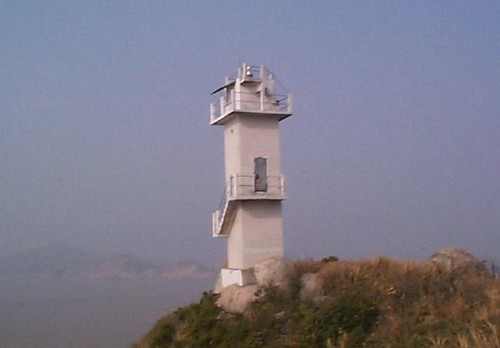
Date unknown. Active; focal plane 16.5 m (54 ft); four white flashes every 10 s. 7 m (23 ft) round concrete tower colored with red and white horizontal bands. Lawrence Li has the photo seen at right and Google has an indistinct satellite view. Located at the northeast end of an island about 1.6 km (1 mi) east of the Gēshāndōng Light. Accessible only by boat. Site and tower closed. CN-2863.5; Admiralty P3643.15.

Xié'ào Light, Xiápǔ County, August 2011
Google Maps photo by Lawrence Li
Xiǎoyúshān (2)
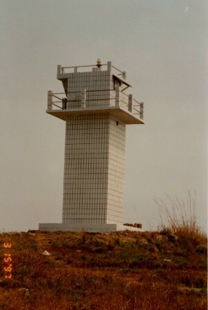
1985 (station established 1955). Active; focal plane 79 m (259 ft); two white flashes every 6 s. 10 m (33 ft) square cylindrical concrete tower with gallery, covered with white ceramic tile. A photo is at right and Google has an indistinct satellite view. Located at the western tip of the island of Xiǎoyúshān, about 8 km (5 mi) east of Sānshā, marking the northern entrance to the Qùpí Pass, a narrow passage around the end of the Sānshā peninsula. Site status unknown. CN-2862; Admiralty P3643.1.
Dàjīlóng (Dàjīlóng Dǎo)
2007. Active; focal plane 16 m (49 ft); two white flashes every 10 s. 8 m (26 ft) square cylindrical concrete tower with gallery, covered with white ceramic tile. No photo available but Google has an indistinct satellite view. Located at the southeastern entrance to the Qùpí Pass. Site status unknown. CN-2862.5; Admiralty P3643.05.
Chūbìménzhúpái (2)
1991 (station established 1955). Active; focal plane 14 m (46 ft); white flash every 4 s. 9.5 m (31 ft) square cylindrical concrete tower with gallery, covered with white ceramic tile. No photo available but Google has a satellite view. Located on a reef at the southern entrance to the Qùpí Pass. Site status unknown. CN-2863; Admiralty P3643.
Yuánjiāoyǔ (Yuánjiāo Yǔ)
2007. Active; focal plane 12 m (49 ft); white flash every 6 s. 8 m (26 ft) square cylindrical concrete tower with gallery, covered with ceramic tile colored with red and white horizontal bands. No photo available but Google has an indistinct satellite view. Located about 500 m (0.3 mi) southwest of the Chubimenzhupai light. Site status unknown. CN-2866.1; Admiralty P3642.9.

Xiǎoyúshān Light, Sānshā Peninsula
PRC Maritime Safety Administration Shànghǎi Region photo
Huánghuājiāo (Huánghuā Jiāo, Yellow Reef)
2007. Active; focal plane 15 m (49 ft); four white flashes every 15 s. 8 m (26 ft) square cylindrical concrete tower with gallery, covered with ceramic tile colored with red and white horizontal bands. No photo available but Google has an indistinct satellite view. Located about 500 m (0.4 mi) west southwest of the Yuanjiaoyu light. Site status unknown. CN-2866.2; Admiralty P3642.85.
Xiàlúdǎo (Xialú Dǎo)
2008. Active; focal plane 45 m (148 ft); two white flashes every 6 s. 7 m (23 ft) hexagonal cylindrical concrete tower, colored with black and white horizontal bands. No photo available but Bing has an indistinct satellite view. Located on a small island off the south coast of the Huángqí Peninsula. Accessible only by boat. Site status unknown. CN-2868.4; Admiralty P3643.5.
Xiǎojiāo ("Little Reef")
Date unknown. Active; focal plane 8 m (26 ft); two white flashes every 6 s. 10 m (33 ft) white concrete tower. No photo available but Google has a satellite view. Located on a reef about 1.5 mi (2.5 km) south of Sānshā. Accessible only by boat. Site status unknown. CN-2867; Admiralty P3643.4.

Dōngchōng Peninsula Lighthouses
Yúyǔ (Fish Island)
Date unknown. Active; focal plane 13 m (43 ft); white flash every 4 s. 8 m (26 ft) concrete tower painted with red and white horizontal bands. No photo available but Google has an indistinct satellite view. Located on an islet off the northeast shoulder of the Dōngchōng peninsula. Accessible only by boat. Site and tower closed. CN-2868.5; Admiralty P3642.8.
Jiàbēi (2)
1998 (station established 1955). Active; focal plane 54 m (177 ft); white flash every 5 s. 12.5 m (41 ft) round concrete tower with gallery, covered with white ceramic tile. MSA's photo is at right and Google has a satellite view. Located on a small island off the northeast shoulder of the Dōngchōng peninsula. Accessible only by boat. Site and tower closed. CN-2869; Admiralty P3642.5.
Lǘtóuwěi
2007. Active; focal plane 19 m (62 ft); two white flashes every 6 s. 8 m (26 ft) square cylindrical concrete tower with gallery, covered with ceramic tile colored with red and white horizontal bands. No photo available but Google has an indistinct satellite view. Located on a sharp promontory on the southeast side of the Dōngchōng peninsula. Site status unknown. CN-2869.3; Admiralty P3642.4; NGA 19090.9.
Chángcǎoyǔ (Chángcǎo Yǔ)
Date unknown. Active; focal plane 27 m (89 ft); white flash every 4 s. 8 m (26 ft) square concrete tower with gallery. Entire lighthouse is white. No photo available but Google has a distant satellite view. This light and the next one frame a passage between the Dōngchōng peninsula and Fúyīng Island. Located on a small island off the south coast of the Dōngchōng peninsula. Accessible only by boat. Site and tower closed. CN-2869.5; Admiralty P3642.3; NGA 19090.7.
Qīngtánjiāo (Qīngtán Jiāo)
2008. Active; focal plane 7 m (23 ft); two white flashes every 6 s. 7 m (23 ft) hexagonal concrete tower colored with black and white horizontal bands. No photo available but Google has an indistinct satellite view. Located on a reef off the southern coast of the Dōngchōng Peninsula. Accessible only by boat. Site status unknown. CN-2869.7; Admiralty P3641.91; NGA 19091.47.

Jiàbēi
Light, Dōngchōng, August 1998
PRC MSA Shànghǎi Region photo
Niújiǎozhi (2?)
Date unknown. Active; focal plane 9 m (30 ft) (?); two green flashes every 6 s. 5 m (17 ft) (?) square pyramidal concrete tower. No photo available but Google has an indistinct satellite view. This light marks the east side of the entrance to Sānshā Bay; in the photo it appears taller than the listed height. Located at the tip of a sharp promontory at the southwestern tip of the Dōngchōng Peninsula. Site status unknown. CN-2873; Admiralty P3641.62.

Fúyīng and Xīyáng Islands Lighthouses
These islands lie off the southeast coast of the Dōngchōng Peninsula.

Liù'ěr (2)
1986 (station established 1955). Active; focal plane 28 m (92 ft); three white flashes every 10 s. 9.5 m (31 ft) hexagonal concrete tower with gallery, painted white. No photo available but Google has an indistinct satellite view. Located on an isolated rocky pinnacle in the channel off the southwestern tip of Fúyīngdǎo. Accessible only by boat. Site and tower closed. CN-2870; Admiralty P3642; NGA 19090.5.
Mǎcìdǎo (Mǎcì Dǎo)
2008. Active; focal plane 32 m (105 ft); two white flashes every 6 s. 7 m (23 ft) hexagonal concrete tower colored with black and white horizontal bands. No photo available but Google has a satellite view. Located at the southwestern tip of Mǎcìdǎo, an island south of Fúyīngdǎo. Accessible only by boat. Site status unknown. CN-2870.07; Admiralty P3641.94; NGA 19091.38.
Kuíshāndǎo (Kuíshān Dǎo)
Date unknown. Active; focal plane 76.5 m (251 ft); white flash every 4 s. 11.5 m (38 ft) round cylindrical concrete tower with gallery, covered with white tile. No photo available but Google has a satellite view. Located on a small island at the southeast corner of the Xīyáng group. Accessible only by boat. Site and tower closed. CN-2870.1; Admiralty P3641.95; NGA 19091.
Wúcǎoyǔ (Wúcǎo Yǔ)
2008. Active; focal plane 15 m (49 ft); two white flashes every 4 s. 7 m (23 ft) hexagonal concrete tower colored with red and white horizontal bands. No photo available but Google has an indistinct satellite view. The name means "No Grass Islet." Located on an islet off the northern tip of Xīyángdǎo. Accessible only by boat. Site status unknown. CN-2870.05; Admiralty P3641.935; NGA 19091.35.
Èrjiānyán (Èrjiān Yán)
2008. Active; focal plane 19 m (62 ft); two white flashes every 6 s. 8 m (26 ft) hexagonal concrete tower colored with black and white horizontal bands. No photo available but Google has a distant satellite view. Located on an islet off the southwestern tip of Xīyángdǎo. Accessible only by boat. Site status unknown. CN-2871.9; Admiralty P3641.88; NGA 19091.28.
Mǎ'ānzǐdǎo (Mǎ'ānzǐ Dǎo)
Date unknown. Active; focal plane 15 m (49 ft); white flash every 6 s. 8 m (26 ft) square white concrete tower. No photo available but Google has an indistinct satellite view. Located on a reef off the western tip of Mǎ'ānzǐdǎo, about 4 km (2.5 mi) northwest of Xīyángdǎo. Accessible only by boat. Site status unknown. CN-2871.5; Admiralty P3641.93; NGA 19091.3.
Xiǎoxīyángdǎo
Date unknown. Active; focal plane 12.5 m (41 ft); three white flashes every 10 s. 8.5 m (28 ft) concrete tower colored with black and white horizontal bands. No photo available but Google has an indistinct satellite view. Located on the south side of the island of Xiǎoxīyáng west of Xīyángdǎo. Accessible only by boat. Site status unknown. CN-2871.2; Admiralty P3641.92; NGA 19091.45.
Wūyǔ (Wū Yǔ, Isthmus Island) (3)
1996 (station established 1954). Active; focal plane 98 m (322 ft); white flash every 4 s. 9 m (30 ft) square cylindrical concrete tower with double gallery, covered with white ceramic tile. A Shànghǎi MSA photo is at right and Bing has a distant satellite view. Located on a small island between Xīyángdǎo and the Dōngchōng peninsula. Accessible only by boat. Site and tower closed. CN-2871; Admiralty P3641.9.
Wuyu Light
Wūyǔ Light, Xīyáng Islands, March 1997
PRC MSA Shànghǎi Region photo
Sìtuǐyǔ (Sìtuǐ Yǔ) (2)
1984 (station established 1954). Active; focal plane 44 m (144 ft); two white flashes every 6 s. 13 m (43 ft) hexagonal concrete tower, painted white. No photo available but Google has a satellite view. The name means "Four-legged Islet." Located on an islet about 7 km (4.5 mi) west of Xīyángdǎo. Accessible only by boat. Site and tower closed. CN-2872; Admiralty P3641.8.

Sānshā Bay Lighthouses

Sānshā Bay (also called Sāndūào) is a complex system of inlets and waterways protected by the Dōngchōng Peninsula. Níngdé City, the capital of the prefecture, is located on one of the western arms of the bay.

Xiápǔ County Lighthouse
Lóngbíchuānjiǎo (Lóngbíchuān Jiǎo)
2012(?). Active; focal plane 16 m (52 ft); two white flashes every 6 s. 7 m (23 ft) round cylindrical concrete tower, covered with ceramic tile colored with red and white horizontal bands. No photo available and the lighthouse is barely visible in Bing's indistinct satellite view. Located at the tip of a promontory in the northeastern section of Sānshā Bay. Site status unknown. CN-2893.7; Admiralty P3641.709.

Fú'ān City Lighthouses
Qīngyǔzǐ
2012(?). Active; focal plane 9 m (30 ft); two white flashes every 6 s. 7 m (23 ft) round white concrete tower. The light is at the far right in a photo of the harbor and Google has a distant satellite view. Located on an islet off the promontory at the east side of the the entrance to Báimǎ Harbor in upper Sānshā Bay. Site status unknown. CN-2899.7; Admiralty P3641.695.
Táijiǎo (Tái Jiǎo)
2012(?). Active; focal plane 9 m (30 ft); two white flashes every 6 s. 7 m (23 ft) round white concrete tower. The light is at the far right in a photo of the harbor entrance and Google has a satellite view. Located on a promontory at the west side of the entrance to Báimǎ Harbor in upper Sānshā Bay. Site status unknown. CN-2899.8; Admiralty P3641.693.
Fúyǔ (Fú Yǔ)
2012(?). Active; focal plane 8 m (26 ft); two white flashes every 6 s. 7 m (23 ft) round white concrete tower. No photo available but Google has a distant satellite view. Located at the tip of a promontory on upper Sānshā Bay, about 3 km (2 mi) north of the Niǎoyǔ lighthouse. Site status unknown. CN serial 6111021 (ex-2910.5); Admiralty P3641.707.

Jiāochéng District Lighthouses
The Jiāochéng District occupies the west and southwest side of Sānshā Bay, including downtown Níngdé.
 
Hóulóngqíjiǎo (Niǎoyǔ, Hóulóngqí Jiǎo)
2012(?). Active; focal plane 9 m (30 ft); two white flashes every 6 s. 9 m (30 ft) round white concrete tower. No photo available but Bing has a satellite view. Located at the eastern tip of Niǎoyǔ (Bird Island), an island about 13 km (8 mi) northeast of Níngdé. Site status unknown. CN serial 6111022 (ex-2909.7); Admiralty P3641.706.
Chángqiāowěi (Sāndōudǎo, Sandu Dao, Chángqiāo Wěi)
2012(?). Active; focal plane 16 m (52 ft); two white flashes every 6 s. 10 m (33 ft) hexagonal cylindrical concrete tower, covered with ceramic tile colored with red and white horizontal bands. No photo available but Google has a satellite view. Located at the eastern end of Sāndōudǎo, a large island in the center of Sānshā Bay. Site status unknown. CN-2898; Admiralty P3641.685.
Báipáodǎo
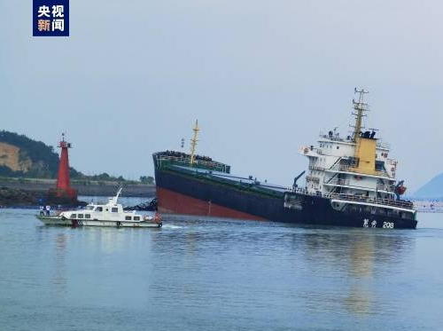
Date unknown. Active; focal plane 10 m (33 ft); three red flashes every 10 s. 11 m (30 ft) red concrete tower. The news photo at right shows the coastal tanker Shinan 208 aground next to the lighthouse on 21 July 2022. Google has a satellite view. Located off the northeastern tip of Báipáodǎo, an island northeast of Sāndōudǎo. Accessible only by boat. Site status unknown. CN-2894.5; Admiralty P3641.71.
Chángyāodǎo
Date unknown. Active; focal plane 10 m (33 ft); three green flashes every 10 s. 11 m (30 ft) green concrete tower. No photo available but Google has a satellite view. Located off the northwestern tip of Báipáodǎo, an island east of Báipáodǎo. Accessible only by boat. Site status unknown. CN-2893.5; Admiralty P3641.74.
Xiàngbítóu (Xiàngbí Tóu, Qīngshāndǎo)
2012(?). Active; focal plane 20 m (66 ft); white flash every 4 s. 10 m (33 ft) hexagonal cylindrical concrete tower, covered with ceramic tile colored with red and white horizontal bands. No photo available and Google has only an indistinct satellite view. Located at eastern end of Qīngshāndǎo, an island in Sānshā Bay. Site status unknown. CN-2889.5; Admiralty P3641.67; NGA 19091.72.
Jīwěijiǎo (Jīgōngshān, Jīwěi Jiǎo)
2012(?). Active; focal plane 12 m (39 ft); three white flashes every 10 s. 10 m (33 ft) hexagonal cylindrical concrete tower, covered with ceramic tile colored with red and white horizontal bands. No photo available but Google has an indistinct satellite view. Located at the tip of a promontory on the northeastern tip of Jīgōngshān, an island in the entrance to Sānshā Bay. Site status unknown. CN-2875.1; Admiralty P3641.635; NGA 19091.75.
Jīgōngshān West
2012(?). Active; focal plane 8 m (26 ft); white flash every 4 s. 7 m (23 ft) round white concrete tower. No photo available but Bing has a distant satellite view. Located at the western tip of Jīgōngshān. Site status unknown. CN-2875.2; Admiralty P3641.63; NGA 19091.7.

Báipáodǎo
Light, Níngdé, July 2022
Sohu.com news photo
Hǔwěijiǎo (Hǔwěi Jiǎo)
2012(?). Active; focal plane 14 m (46 ft); two white flashes every 6 s. 10 m (33 ft) hexagonal cylindrical concrete tower, covered with ceramic tile colored with red and white horizontal bands. No photo available but Google has a distant satellite view. Located at the tip of a promontory on the west side of the entrance to Sānshā Bay. Site status unknown. CN-2874.1; Admiralty P3641.625; 19091.6.

Adjoining pages: North: Ruì'ān Area | South: Fúzhōu

Return to the Lighthouse Directory index | Ratings key

Posted July 7, 2008. Checked and revised January 4, 2024. Lighthouses: 49. Site copyright 2024 Russ Rowlett and the University of North Carolina at Chapel Hill.