Lighthouses of China: Fúzhōu, Fújiàn

China, officially Zhōngguó (中华), has been the largest and most dominant nation of East Asia since it was unified under a single emporer in 221 BCE. However imperial power waned during the nineteenth century, allowing European colonial powers to enter the country. Britain, France, Portugal, Germany, and Russia all established outposts in China. European engineers developed Chinese ports and built the first Western lighthouses, many of which remain in service today. After the imperial government was overthrown in 1912 China entered a long period of instability. The civil war between republican and Communist forces began in 1927. In 1937 Japan invaded, occupying large parts of China and starting a war that merged with World War II. After that war ended in 1945 civil war resumed and by 1949 the Communists achieved control of the entire mainland, the republicans retreating to the island of Taiwan.

Today the People's Republic of China (PRC) has a lengthy coastline, many large harbors, and a large number of lighthouses. The country is divided into 22 provinces and 11 other province-level regions of various special types. The province of Fújiàn (formerly spelled Fukien or Fuchien) is located on the southeastern coast of the country facing Taiwan across the Taiwan Strait. The coastline is rugged and irregular with many islands and reefs threatening unwary navigators. Many bays cut deeply into the mainland.

Fújiàn is divided into nine prefectural-level cities, six of them facing the coast. This page includes lighthouses of the northern 2/3 of the prefectural level city of Fúzhōu in the northern part of the province.

The Matsu (Mǎzǔ) Islands, lying in the Taiwan Strait off the entrance to Fúzhōu, have been under the administration of the Republic of China government on Taiwan since 1949. The two historic lighthouses of Matsu are described on the Matsu and Kinmen page.

There are many languages and dialects spoken in China, but Standard Chinese, often called Mandarin, is official. The pīnyīn system for transliterating Standard Chinese into Latin characters is now the international standard but some locations continue to be known also under the spellings of older transliteration systems. The Chinese word for a lighthouse is dēngtǎ (灯塔). In Standard Chinese jiāo (formerly chiao) is a reef or rock, jiǎo is a cape or headland, dǎo (tao) is an island; (tsu) or tuózi ("lump") is a small island, hǎi is a sea, wān is a bay, hǎixiá is a strait, or jiāng is a river, hékǒu ("river mouth") is an estuary, and gǎng (kang) is a harbor.

Lighthouses in China are maintained by the PRC Maritime Safety Administration. The administration is organized in four regional administrations with district offices in the major ports. All the lights on this page are maintained by the Fúzhōu MSA office, which is part of the Shànghǎi Region.

ARLHS numbers are from the ARLHS World List of Lights. CN numbers are the MSA List of Lights (助航标志表) numbers. Admiralty numbers are from volume P of the Admiralty List of Lights & Fog Signals. U.S. NGA List numbers are from Publication 112.

General Sources
Online List of Lights - China
Photos by various photographers posted by Alexander Trabas.
Chinese English Pinyin Dictionary
A useful tool for juggling the representations of Chinese names.
Navionics Charts
Navigational chart for Fúzhōu

Dalujiao Light
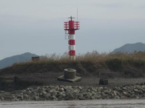
Dàlújiāo Light, Mǐnjiāng, Fúzhōu
PRC Maritime Safety Administration Fúzhōu Office photo
Fèngchéng Area Lighthouses

Luōyuán County Lighthouses
Dōngguīyǔ (Dōngguī Yǔ)
Date unknown. Active; focal plane 13 m (43 ft); three white flashes every 5 s. 7 m (30 ft) hexagonal concrete tower with gallery, painted with red and white horizontal bands. No photo available but Google has a satellite view. Located on the eastern tip of an island marking the west side of the entrance to Sānshā Bay (lighthouses within the bay are described on the Níngdé page). Site status unknown. CN-2872.1; Admiralty P3641.598; NGA 19091.59.
Xiǎohuángjiāo (Xiǎohuáng Jiāo)
Date unknown. Active; focal plane 10 m (33 ft); two white flashes every 5 s. 13 m (43 ft) hexagonal concrete tower, painted black with a red horizontal band. No photo available but Google has a satellite view. Located on a reef on the north side of the entrance to Luōyuán Bay. Accessible only by boat. Site open, tower closed. CN-2924.1; Admiralty P3641.54.
Xiàdānyǔ (Xiàdān Yǔ)
Date unknown. Active; focal plane 28 m (92 ft); two white flashes every 6 s. 10 m (33 ft) hexagonal white concrete tower with gallery. A very distant view is available (light at the far left) and Google has a satellite view. Located on an island in the center of the narrow strait that is the mouth of Luōyuán Bay. Accessible only by boat. Site status unknown. CN-2925; Admiralty P3641.56.
Gǎngyǔ (Gǎng Yǔ)
Date unknown. Active; focal plane 63 m (207 ft); two white flashes every 6 s. 10 m (33 ft) hexagonal white concrete tower with gallery. No photo available but Google has a satellite view. Located on a high island in the southeastern corner of Luōyuán Bay. Accessible only by boat. Site status unknown. CN-2926; Admiralty P3641.575.
Niǎoyǔ (Niǎo Yǔ, Bird Island)
Date unknown. Active; focal plane 20 m (66 ft); white flash every 4 s. 12 m (39 ft) hexagonal white concrete tower with gallery. No photo available but Google has an indistinct satellite view. Located on an island in the southeastern corner of Luōyuán Bay, about 1.5 km (1 mi) northwest of the Gangyu lighthouse. Accessible only by boat. Site status unknown. CN-2926.2; Admiralty P3641.58.

Liánjiāng County Lighthouses
The Matsu Islands are also part of Liánjiāng County; since they are administered by Taiwan their lighthouses are on a separate page.

Gǔdǐngyǔ (Gǔdǐng Yǔ)
Date unknown. Active; focal plane 46 m (151 ft); white flash every 4 s. 9 m (30 ft) hexagonal white concrete tower with gallery. A distant aerial view is available (lighthouse atop the small island in the center) and Google has a satellite view. Located on an island at the western entrance to the narrow strait that is the mouth of Luōyuán Bay. Accessible only by boat. Site status unknown. CN-2925.2; Admiralty P3641.57.
Kěméntóu (Kěmén Tóu)
Date unknown. Active; focal plane 53 m (174 ft); white flash every 4 s. 9 m (30 ft) hexagonal white concrete tower with gallery. No photo available but Google has a satellite view. Located on an island off the north end of the Huángqí Peninsula. Accessible only by boat. Site status unknown. CN-2924.2; Admiralty P3641.55.
Kěménjiǎo
Date unknown. Active; focal plane 87.5 m (287 ft); three white flashes every 10 s. 9 m (30 ft) hexagonal white concrete tower with gallery. No photo available but Google has a satellite view. Located on the point of Kěménjiǎo, the northeastern tip of the Huángqí Peninsula, marking the entrance to Luōyuán Bay. Accessible by road. Site status unknown. CN-2923; Admiralty P3641.5.
Xīluòdǎo (Xīluò Dǎo) (2)
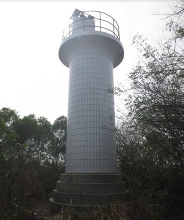
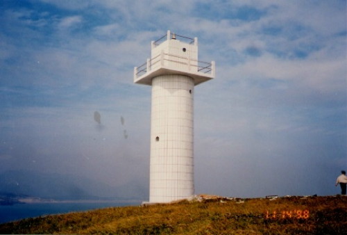
1989 (station established 1957). Active; focal plane 36 m (118 ft); four white flashes every 12 s. 11 m (36 ft) hexagonal concrete tower with gallery, covered with white ceramic tile. An MSA photo is at right and Google has a satellite view. Located on an island about 5 km (3 mi) offshore in the bay north of the Huángqí Peninsula. Accessible only by boat. Site status unknown. CN-2922; Admiralty P3641.4.
Xiluodao Light
Xiluodao Light, Liánjiāng, Fúzhōu, November 1997
PRC Maritime Safety Administration Fúzhōu Office photo
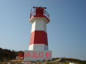
Dōngluòdǎoběi (Dōngluò Dǎo North)
Date unknown. Active; focal plane 58 m (190 ft); three white flashes every 10 s. 7 m (23 ft) hexagonal concrete tower, painted with red and white horizontal bands. MSA's photo is at right and Google has a satellite view. Located on the northeastern tip of an island about 10 km (6 mi) east of Kěménjiǎo. Accessible only by boat. Site status unknown. CN-2921.7; Admiralty P3641.38; NGA 19091.52.
Nánwěiyǔ (Nánwěi Yǔ)
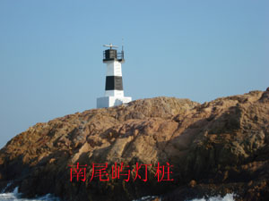
Date unknown. Active; focal plane 18 m (59 ft); white flash every 4 s. 7 m (23 ft) hexagonal concrete tower, painted with black and white horizontal bands. An MSA's photo is at right and Google has a satellite view. Located on the northeastern tip of an island about 7 km (4.5 mi) south of Dōngluòdǎo. Accessible only by boat. Site status unknown. CN-2921.5; Admiralty P3641.35; NGA 19091.51.

Dōngluòdǎoběi Light (left) and Nánwěiyǔ Light
PRC Maritime Safety Administration Fúzhōu Office photos
Xiǎoniújiāo (Calf Reef) (2)
1989 (station established 1954). Active; focal plane 13 m (43 ft); white flash every 10 s. 14 m (46 ft) octagonal concrete tower with gallery, painted black with one red horizontal band. No photo available but Google has a satellite view. Located on a reef about 1.5 km (1 mi) north of the sharp Běijiāo promontory at the end of the Huángqí Peninsula about 10 km (6 mi) northeast of Huángqí. Accessible only by boat. Site and tower closed. CN-2921; Admiralty P3641.3.
Yángyǔ (Yáng Yǔ, Jianyu) (3)
1994 (station established 1954). Active; focal plane 101 m (331 ft); two white flashes every 6 s. 10 m (33 ft) square concrete tower with gallery, covered with white ceramic tile. No photo available but Google has an indistinct satellite view. Located atop a small island just off Běijiāo and about 3 km (2 mi) east of Kěménjiǎo. Accessible only by boat. Site and tower closed. CN-2920; Admiralty P3641.2; NGA 19091.5.
Hēiyándǎo (Hēiyán Dǎo)
Date unknown. Active; focal plane 46 m (151 ft); three white flashes every 10 s. 13.5 m (44 ft) hexagonal concrete tower with gallery, painted with red and white horizontal bands. No photo available and the light is not distinguishable in Google's indistinct satellite view. Located on an isolated skerry about 10 km (6 mi) east of Yángyǔ. Accessible only by boat. Site and tower closed. CN-2919.5; Admiralty P3641.1; NGA 112-19091.2.
Píngniúyǔ (2)
1988 (station established 1955). Active; focal plane 12 m (39 ft); three white flashes every 10 s. 13 m (43 ft) hexagonal pyramidal concrete tower, painted white. MSA's photo is at right and Google has a satellite view. Located atop a reef about 3 km (2 mi) southeast of Huángqízhèn. Accessible only by boat. Site and tower closed. CN-2929; Admiralty P3641; NGA 19091.53.
Dōnggǔyǔ (Dōnggǔ Yǔ)
2011. Active; focal plane 12 m (39 ft); white flash every 4 s. 11 m (36 ft) round concrete tower, colored with red and white horizontal bands. No photo available but Bing has a distant satellite view. Located on a reef about 8 km (5 mi) off the south side of the Huángqí Peninsula. Accessible only by boat. Site and tower closed. CN-2929.1; Admiralty P3641.05; NGA 19091.55.
Lànggǎngniú (Longweng Yu) (2)
1998 (station established 1955). Active; focal plane 26 m (85 ft); two white flashes every 6 s. 14 m (46 ft) round cylindrical concrete tower with gallery, covered with white ceramic tile. No photo available but Google has a distant satellite view. Located on a small island about 12 km (7.5 mi) southwest of Huángqí. Accessible only by boat. Site and tower closed. CN-2931; Admiralty P3640.2.
Guīyǔniú (2)
1997 (station established 1955). Active; focal plane 9 m (30 ft); white flash every 4 s. 11 m (43 ft) round cylindrical white concrete tower. No photo available but Google has a satellite view. Located on a reef just off the south side of the Huángqí Peninsula. Accessible only by boat. Site open, tower closed. CN-2932; Admiralty P3640.4.

Píngniúyǔ Light, Huángqízhèn, January 2000
PRC Maritime Safety Administration Shànghǎi Region photo
Sìmǔyǔ (Sìmǔ Yǔ)
1982. Active; focal plane 40.5 m (133 ft); four white flashes every 12 s. 14 m (46 ft) square concrete tower with gallery, covered with white ceramic tile. No photo available but Google has a satellite view. Located on a small island in the bay about 8 km (5 mi) south of the Huángqí Peninsula. Accessible only by boat. Site and tower closed. CN-2933; Admiralty P3640.
Wūzhū Mén (Wūzhū Entrance)
Date unknown. Active; focal plane 15 m (49 ft); white flash every 4 s. 9 m (30 ft) square cylindrical white concrete tower. No photo available but Google has a satellite view. Located on the north side of the entrance to Wūzhū harbor. Site status unknown. CN-2955; Admiralty P3635.5.
Dōng'àn (East Bank)
Date unknown. Active; focal plane 9 m (30 ft); red flash every 4 s. 8.5 m (28 ft) red concrete tower. No photo available but Google has a satellite view. Located on the northwest point of Cūlú Island, the east bank of Wūzhū harbor. Site status unknown. CN-2956; Admiralty P3635.52.
Hèyǔ
Date unknown. Active; focal plane 7.5 m (25 ft); thre white flashes every 10 s. 8 m (26 ft) concrete tower colored with black and white horizontal bands. Google has a satellite view and the light is left of center in a distant 2013 photo. Located on a small island off the west side of Chuānshí island, on the north side of the entrance to Fúzhōu. Accessible only by boat. Site open, tower closed. CN-2951.3; Admiralty P3635.417; NGA 19114.1.
Hǔzhōu
Date unknown. Active; focal plane 10 m (33 ft); white flash every 4 s. 9.5 m (31 ft) concrete tower colored with black and white horizontal bands. Google has a satellite view and the light can be seen in the left distance (on the far side of the bay) in a distant 2013 photo. Located in a channel on the west side of Chuānshí island. Accessible only by boat. Site open, tower closed. CN-2951.1; Admiralty P3635.415; NGA 19114.25.
Jìnyǔ
Date unknown. Active; focal plane 12.5 m (41 ft); two white flashes every 6 s. 8.5 m (28 ft) concrete tower colored with red and white horizontal bands. Huang Zhiqin has the fuzzy distant view seen at right, the light is just on the left of the rounded island in a distant 2013 photo, and Google has a satellite view. Located on a small island off the northwest side of Chuānshí island. Accessible only by boat. Site open, tower closed. CN-2951.2; Admiralty P3635.416.
 

Jìnyǔ Light, Fúzhōu, October 2016
Google Maps photo by Huang Zhiqin
 

Fúzhōu Metropolitan Area Lighthouses

Fúzhōu (formerly Foochow), the capital of Fújiàn Province, has a metropolitan population of roughly three million people. The city straddles the Mǐnjiāng (Min River) estuary about 50 km (30 mi) from the sea. At its mouth the estuary is divided into northern and southern branches by the large island of Huángqíshān.

Liánjiāng County Lighthouses
Qīxīngjiāo (Qīxīng Jiāo) (2)
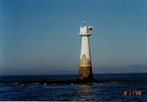
1985 (station establishment date unknown). Active; focal plane 16 m (52 ft); white flash every 6 s. 16 m (52 ft) round concrete tower with gallery, painted white. MSA's photo is at right but the reef is not seen in Google's satellite view. Located on a reef about 15 km (9 mi) east of the Mǐnjiāng estuary entrance. Accessible only by boat. Site and tower closed. CN-2939; Admiralty P3634.4; NGA 19128.
Rìzhuāngjiāo (Lizhuangjiao) (3)
1997 (station established 1957). Active; focal plane 18 m (59 ft); two white flashes every 6 s. 18 m (59 ft) round concrete tower with gallery, covered with white ceramic tile. No photo available and Google has only a fuzzy satellite view. The original light was destroyed by a typhoon in 1983. Located on a reef on the south side of the Mǐnjiāng entrance. Accessible only by boat. Site and tower closed. CN-2940; Admiralty P3634.8; NGA 19092.
Chuānshídǎo South
Date unknown. Active; focal plane 13 m (43 ft); white flash every 4 s. 8.5 m (28 ft) concrete tower colored with red and white horzontal bands. Chen Huang has a distant photo (the light is on the shore left of center) and Google has an indistinct satellite view. Located on the southern tip of Chuānshí island. Accessible only by boat. Site open, tower closed. CN-2951.5; Admiralty P3635.43.
Báiyúnshān Range Front
1974. Active; focal plane 47 m (154 ft); white flash every 1.5 s. 22 m (72 ft) concrete structure, painted white with a red vertical stripe. No photo available but Google has an indistinct satellite view. The light is not a traditional tower but a concrete wall set into the side of Báiyún Mountain. This is the approach range for the Mǐnjiāng estuary, which leads to the major port of Fúzhōu. Located on a mountain at the eastern end of Hòulóngshān, a forested ridge on the island of Huángqíshān, in the center of the Mǐnjiāng delta. Site status unknown. CN-2941; Admiralty P3635; NGA 19096.
Qixingjiao Light
Qīxīngjiāo Light, Fúzhōu, November 1998
PRC Maritime Safety Administration Shànghǎi Region photo
Báiyúnshān Range Rear
1974. Active; focal plane 94 m (308 ft); white light occulting once every 4 s. 22 m (72 ft) concrete tower, painted white with a red vertical stripe. No photo available but Bing has a fuzzy satellite view. Located on the Hòulóngshān ridge about 1290 m (0.8 mi) west of the front light. Site status unknown. CN-2942; Admiralty P3635.1; NGA 19100.
Zhàiwěishān (Fúdòushān Eastbound) Range Rear (4)
2004 (station established 1974). Active; focal plane 42 m (138 ft); white light, 1 s on, 1 s off. 9 m (30 ft) square tower. The front of the tower is faced with a wide concrete wall covered with tile colored red with a white vertical stripe. No photo available but Google has a satellite view. This range guides vessels leaving the Mǐnjiāng estuary. Located on the western tip of an island 2 km (1.25 mi) east of the common front light (next entry). Site status unknown. CN-2951; Admiralty P3635.42; NGA 19114.
Xīfēng Shí (Common Range Front) (3)
2004 (station established 1974). Active; focal plane 15 m (49 ft); white light, 1 s on, 1 s off. 7 m (23 ft) square tower. The front of the tower is faced with a wide concrete wall covered with tile colored red with a white vertical stripe. No photo available but Google has an indistinct satellite view. This is the front light tower for both the outbound Zhaiweishan and inbound Fúdòushān ranges. Located on the southern tip of Hǔchóudǎo, on the north side of the northern branch of the Mǐnjiāng estuary. Site status unknown. CN-2950; Admiralty P3635.4; NGA 19112.
Fúdòushān (Fúdòu Shān) Westbound Range Rear (4)
2004 (station established 1974). Active; focal plane 63 m (207 ft); white light, 2 s on, 2 s off. 15 m (49 ft) tower. The front of the tower is faced with a wide concrete wall covered with tile colored red with a white vertical stripe. No photo available but Google has a satellite view. This is the main entrance range for Fúzhōu. Located atop a ridge on the north side of the northern branch of the Mǐnjiāng estuary. Site status unknown. CN-2952; Admiralty P3635.41; NGA 19116.
Báitǎ (Hújiāng Dǎo)
1953. Active; focal plane 26 m (85 ft); three white flashes every 10 s. 7 m (23 ft) round cylindrical brick tower covered with white tiles. A photo is at right and Google has an indistinct satellite view. Located at the northeast corner of an island marking the south side of the entrance to the Mǐnjiāng estuary. Site status unknown. CN-2948; Admiralty P3635.2; NGA 19104.

Báitǎ Light, Mǐnjiāng, Fúzhōu
Google Maps photo by 海狼王 ("Sea Wolf King")
Wūzhūzhōu West
Date unknown. Active; focal plane 8 m (26 ft); three white flashes every 10 s. 6.5 m (21 ft) round tower painted with red and white horizontal bands. A photo is at right and Bing has a satellite view. Located at the west end of an island on the south side of the entrance to the Mǐnjiāng estuary. Site status unknown. CN-2953.3; Admiralty P3635.48.
Nánguīdǎo
Date unknown. Active; focal plane 12.5 m (41 ft); two white flashes every 6 s. 8.5 m (28 ft) round concrete painted with red and white horizontal bands. A photo is available but the light has not seen in Google's satellite view. Located on an island on the south side of the narrow entrance to the Mǐnjiāng. Accessible only by boat. Site open, tower closed. CN-2953.5; Admiralty P3635.46.
 
Jīnpái Mén
Date unknown. Active; focal plane 10 m (33 ft); white flash every 5 s. 10 m (33 ft) octagonal white concrete tower topped by a skeletal tower. No photo available but Google has a satellite view. Located on a reef on the north side of the narrow entrance to the Mǐnjiāng. Accessible only by boat. Site open, tower closed. CN-2958; Admiralty P3635.45; NGA 19120.
 

Wūzhūzhōu Light, Fúzhōu, November 2013
Google Maps photo by 海狼王
 

Mǎwěi District (Mǐnjiāng Estuary) Lighthouses
Jīnpáishān North
Date unknown. Active; focal plane 8 m (26 ft); three white flashes every 10 s. 9 m (30 ft) concrete tower colored with black and white horizontal bands. A photo and a view from the estuary are available and Google has an indistinct satellite view. Located at the tip of a headland opposite the Jīnpái Mén Light. Site status unknown. CN-2953.7; Admiralty P3635.44; NGA 19120.4.
Wèngyǔ (Wèng Yǔ, Yingsha, Urn Island)
Date unknown. Active; focal plane 15 m (49 ft); white flash every 4 s. 9 m (30 ft) octagonal white concrete tower. A photo is available and Google has a satellite view. Located on a reef on the north side of the Mǐnjiāng channel downstream from the bridge and about 6 km (3.5 mi) southwest of Jīnpái Mén. Accessible only by boat. Site open, tower closed. CN-2962; Admiralty P3635.67.
Dàlújiāo (Dàlú Jiāo)
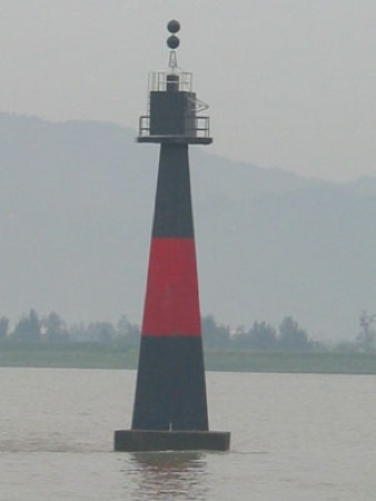
Date unknown. Active; focal plane 8 m (26 ft); two white flashes every 5 s. 13.5 m (44 ft) round tapered concrete tower, painted black with a red horizontal band and mounted on a square concrete pier. The MSA photo is at the top of this page and Google has a satellite view. Located on a shoal of the south side of the Mǐnjiāng channel about 8 km (5 mi) southwest of Jīnpái Mén. Accessible only by boat. Site open, tower closed. CN-2963; Admiralty P3635.65; NGA 19122.
Dōnggāozhài
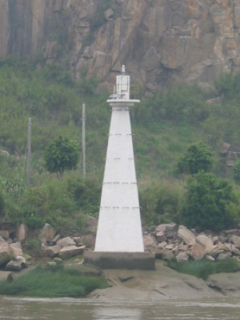
Date unknown. Active; focal plane 12 m (39 ft); white flash every 4 s. 12 m (39 ft) octagonal white concrete tower. The MSA photo is at right, a closeup photo is available, and Google has a satellite view. Located at the water's edge on the west side of a narrow passage of the Mǐnjiāng. Site status unknown, but the light can be seen from the riverside highway. CN-2966; Admiralty P3635.72.
Yanguǎn
Date unknown. Active; focal plane 10.5 m (35 ft); two white flashes every 6 s. 8.5 m (28 ft) concrete tower colored with red and white horizontal bands. A very distant view from across the river is available and Google has an indistinct satellite view. Located on the east side of the Mǐnjiāng about 1 km (0.6 mi) south of the Dōnggāozhài lighthouse. Site status unknown. CN-2966.5; Admiralty P3635.725; NGA 19122.1.
Shímén Xī (Shimen West)
Date unknown. Active; focal plane 10.5 m (35 ft); two white flashes every 6 s. 8.5 m (28 ft) concrete tower colored with red and white horizontal bands. No photo available but Google has a satellite view. Located on the east side of the Mǐnjiāng about 2 km (1.2 mi) south of the Dōnggāozhài lighthouse. Site status unknown. CN-2966.7; Admiralty P3635.723; NGA 19122.2.
 
Donggaozhai Light
Dōnggāozhài Light, Mǐnjiāng, Fúzhōu
PRC Maritime Safety Administration Fúzhōu Office photo
Niúwěi Shān (Oxtail Bluff) (1)
Date unknown. Inactive since 2009. 12 m (39 ft) square white concrete tower. A 2008 photo is available, a December 2009 photo shows both lighthouses, and Google has a satellite view. Located on the east side of the Mǐnjiāng about 3 km (2 mi) south of the Dōnggāozhài lighthouse. Site status unknown, but the light can be seen from the riverside highway.
Niúwěi Shān (Oxtail Bluff) (2)
2009. Active; focal plane 15 m (49 ft); white flash every 4 s. 14 m (46 ft) octagonal white concrete or fiberglass tower mounted on a square concrete pier. A December 2009 photo shows both lighthouses, Lin Jingpai has a view from the nearby Lángqí Mǐnjiāng Bridge, and Google has a satellite view. Located just offshore from the original lighthouse. Site status unknown, but the light can be seen from the riverside highway. CN-2967; Admiralty P3635.73; NGA 19122.25.
Sōngmén (?)
Date unknown. Possibly removed or replaced; listed with focal plane 10 m (33 ft); three white flashes every 10 s. 8.5 m (28 ft) concrete tower colored with red and white horizontal bands. No photo available Bing has an indistinct satellite view. Located on the west side of the Mǐnjiāng opposite the Niúwěi Shān lighthouses. Site status unknown. CN-2967.01; Admiralty P3635.731; NGA 19122.3.
Xiǎomǎjiāo
Date unknown. Active; focal plane 9 m (30 ft); two white flashes every 5 s. 8.5 m (28 ft) concrete tower painted black with one red horizontal band. A distant view taken in 2006 is available and Google has a satellite view. In the 2006 view that tower is painted black on the upper half and yellow on the lower half; this suggests that the preferred channel was switched from the north side to the south side of the shoal. Located on a reef in the Mǐnjiāng just off the China Shipping Heritage Museum in the southern Mǎwěi district. Accessible only by boat. Site open, tower closed. CN-2972; Admiralty P3635.8.

Original Niúwěi Shān Light, Mǎwěi District, Fúzhōu, April 2008
Google Maps photo by 海狼王 ("Sea Wolf King")

Dàmǎjiāo
Date unknown. Active; focal plane 6.5 m (21 ft); green flash every 4 s. 6.5 m (21 ft) green concrete tower. Google has a photo and a satellite view. Located on a reef in the Mǐnjiāng about 1.2 km (3/4 mi) northwest of the Xiǎomǎjiāo light. Accessible only by boat. Site open, tower closed. CN-2974; Admiralty P3635.82.

Chánglè District: Mǐnjiāng Southern Entrance Lighthouses
Jiǔpíngjiāo
Date unknown. Active; focal plane 6 m (20 ft); two red flashes every 6 s. 8 m (26 ft) square red concrete tower mounted on a round concrete pier. A photo is available and Google has a satellite view. Located on the south side of the southern entrance to the Mǐnjiāng about 1 km (0.6 mi) east of the Fúzhōu Ring Expressway Bridge. Accessible only boat. Site status unknown. CN-2981; Admiralty P3635.69; NGA 19110.2.
Mǎjiāo (Sìxìa)
Date unknown. Active; focal plane 8.5 m (28 ft); white flash every 4 s. 8.5 m (28 ft) black concrete tower. No photo available but Google has a satellite view. Located on the south side of the southern entrance to the Mǐnjiāng. Accessible only boat. Site status unknown. CN-2980; Admiralty P3635.68; NGA 19110.
* Shāfēngjiǎo (Shāntǎ Yǔ))
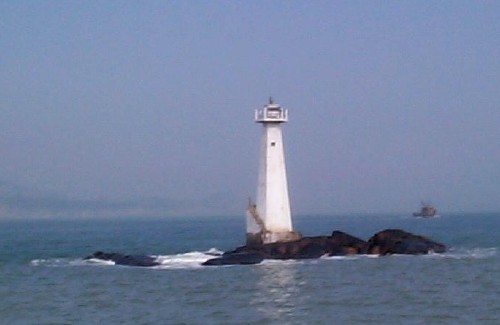
Date unknown. Active; focal plane 15 m (49 ft); white flash every 4 s. Approx. 7 m (23 ft) square pyramidal white concrete tower mounted atop a large stone structure. A photo is at right and Google has a satellite view. Located on a sandy point on the south side of the southernmost entrance to the Mǐnjiāng delta. Site open, tower closed. CN-2977; Admiralty P3634.3.
Bōzhōudǎo (Bōzhōu Dǎo) (2)
1988 (station establishment date unknown). Active; focal plane 21 m (69 ft); three white flashes every 10 s. 11 m (36 ft) square pyramidal concrete tower with gallery, painted white. An external stairway winds around the lower half of the tower. A photo is available and Google has a satellite view. Located on a small island just off the mainland coast about 8 km (5 mi) south of the southern end of the Mǐnjiāng delta. Accessible only by boat. Site and tower closed. CN-2976; Admiralty P3634.2; NGA 19132.5.

Shāfēngjiǎo Light, Chánglè District, Fúzhōu, October 2013
Google Maps photo by 海狼王 ("Sea Wolf King")


Chánglè District: Sōngxià Area Lighthouses
 
Shuāngpí (2)
1985 (station established 1956). Active; focal plane 30 m (98 ft); two white flashes every 6 s. 12 m (39 ft) square concrete tower with gallery, covered with white ceramic tile. No photo available but Google has a satellite view. Located atop a small island about 5 km (3 mi) off the mainland coast and 20 km (12.5 mi) northwest of Haitandao. Accessible only by boat. Site and tower closed. CN-2983; Admiralty P3633.9; NGA 19133.2.
Lì Yǔ
Date unknown. Active; focal plane 25 m (82 ft); three white flashes every 10 s. 11.5 m (38 ft) round concrete tower colored with red and white horizontal bands. No photo available but Google has a distant satellite view. Located on a small island about 15 km (9 mi) east of Shuāngpí. Accessible only by boat. Site and tower closed. CN-2982.1; Admiralty P3633.3; NGA 19133.
Xīluò (Hsi-lo, Sōngxià Gang) (3) (?)
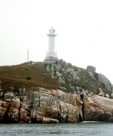
1998 (station established 1956). Probably inactive but listed by NGA with focal plane 54 m (177 ft); red flash every 4 s. 12 m (39 ft) round cylindrical concrete tower with gallery, covered with white ceramic tile. Shànghǎi MSA's photo is at right, a distant aerial view is available, and Google has a satellite view. The 1998 reconstruction may have changed only the top of the tower. This light has been dropped from the Admiralty list. Located on a small island at the south end of the channel, just off Sōngxià harbor. Accessible only by boat. Site and tower closed. ex-CN-2984; ex-Admiralty P3633.8; NGA 19133.4.
Xīluòdǎo Dōng (Xīluò Dǎo Southeast)
Date unknown. Active; focal plane 28 m (92 ft); three white flashes every 10 s. 11 m (36 ft) hexagonal tower, painted with red and white horizontal bands. No photo available but Google has a satellite view. Located on the southeastern tip of Xīluò island. Site status unknown. CN-2983.9; Admiralty P3633.85.
Songxia Gang Light
Sōngxià Gang Light, Sōngxià, November 1998
PRC Maritime Safety Administration Shànghǎi Region photo
Zhūtóujiāo (Zhūtóu Jiāo)
Date unknown. Active; focal plane 7 m (23 ft); nine very quick white flashes every 10 s. 9 m (30 ft) round concrete tower, painted yellow with one black horizontal band. No photo available but Google has an indistinct satellite view. Located on a shoal off the southeastern end of Xīluò. Accessible only by boat. Site and tower closed. CN-2983.3; Admiralty P3633.87; NGA 19133.5.

Adjoining pages: North: Níngdé | East: Matsu and Kinmen | South: Píngtán Area

Return to the Lighthouse Directory index | Ratings key

Posted July 7, 2008. Checked and revised January 11, 2024. Lighthouses: 55. Site copyright 2024 Russ Rowlett and the University of North Carolina at Chapel Hill.