Lighthouses of China: Pútián, Fújiàn

The People's Republic of China (PRC), known officially as Zhōnghuá (中华), has a lengthy coastline, many large harbors, and a large number of lighthouses. The country is divided into 23 provinces and 11 other province-level regions of various special types. The province of Fújiàn (formerly spelled Fukien or Fuchien) is located on the southeastern coast of the country, facing Taiwan across the Taiwan Strait. The coastline is rugged and irregular, with many islands and reefs threatening unwary navigators.

Fújiàn is divided into nine prefectural-level cities, six of them facing the coast. This page covers the prefectural-level city of Pútián on the central coast of the province. Most of the coast of Pútián is in the Xiùyǔ District, which occupies a peninsula between Xīnghuà Bay and Méizhōu Bay and includes the large island of Nánrìdǎo. Except where noted otherwise all the lights on this page are in Xiùyǔ.

The Wūqiū (Wuchiu) Islands off the coast of Pútián have been under the administration of the Republic of China government on Taiwan since 1949. The lighthouse of Wūqiū is described on the Matsu and Kinmen page.

There are many languages and dialects spoken in China, but Standard Chinese, often called Mandarin, is official. The pīnyīn system for transliterating Standard Chinese into Latin characters is now the international standard but some locations continue to be known also under the spellings of older transliteration systems. The Chinese word for a lighthouse is dēngtǎ (灯塔). In Standard Chinese jiāo (formerly chiao) is a reef or rock, jiǎo is a cape or headland, dǎo (tao) is an island; (tsu) or tuózi ("lump") is a small island, hǎi is a sea, wān is a bay, hǎixiá is a strait, or jiāng is a river, hékǒu ("river mouth") is an estuary, and gǎng (kang) is a harbor.

Lighthouses in China are maintained by the PRC Maritime Safety Administration. The administration is organized in four regional administrations with district offices in the major ports. All the lights on this page are maintained by the Xiamen MSA office, which is part of the Shànghǎi Region.

ARLHS numbers are from the ARLHS World List of Lights. CN numbers are the MSA List of Lights (助航标志表) numbers. Admiralty numbers are from volume P of the Admiralty List of Lights & Fog Signals. U.S. NGA List numbers are from Publication 112.

General Sources
Online List of Lights - China
Photos by various photographers posted by Alexander Trabas.
Chinese English Pinyin Dictionary
A useful tool for juggling the representations of Chinese names.
Navionics Charts
Navigation chart for the Pútián area.

Jianyu Light
Jiànyǔ Light, Pútián
PRC MSA Shànghǎi Region photo

Xīnghuà Bay Lighthouses
Xīnghuà Bay is a broad inlet on the east side of Pútián. Lighthouses on the north side of the bay are described on the Píngtán Area page.

Cǎoyǔ (Tǔwěijiǎo)
Date unknown. Active; focal plane 22 m (72 ft); two white flashes every 6 s. 9.5 m (31 ft) square cylindrical concrete tower colored with red and white horizontal bands. A street view from the base of the tower is at right and Google has a satellite view. This lighthouse is in the Líchèng District of Pútián. Located on the northern tip of a small island in the southwest corner of Xīnghuà Bay, just off Pútián. Accessible only by boat. Site status unknown. CN-3039; Admiralty P3627.975.
Xīruobēi (West Ruobēi)
Date unknown. Active; focal plane 14.5 m (48 ft); white flash every 4 s. 10 m (33 ft) square cylindrical white concrete tower. No photo available but Google has a satellite view. Located on the northeastern tip of an island off the south coast of Xīnghuà Bay. Accessible only by boat. Site status unknown. CN-3037; Admiralty P3627.96.
Dōngruobēi (East Ruobēi)
Date unknown. Active; focal plane 24 m (79 ft); two white flashes every 6 s. 8 m (26 ft) square pyramidal white concrete tower. No photo available but Google has a satellite view. Located on the northern tip of an island about 1.25 km (3/4 mi) east of Xīruobēi. Accessible only by boat. Site status unknown. CN-3036; Admiralty P3627.95.
Àiyǔ (Àidǎo)
Date unknown. Active; focal plane 17 m (56 ft); white flash every 4 s. 10 m (33 ft) square cylindrical concrete tower colored with red and white horizontal bands. No photo available but Bing has a satellite view. Located on an islet about 8 km (5 mi) east of Dōnggàobēi in Xīnghuà Bay. Accessible only by boat. Site status unknown. CN-3035; Admiralty P3627.915.

Cǎoyǔ Light, Líchèng, August 2021
Google Maps street view by Henry Wong

Nánrì Strait Lighthouses
These lights guide vessels in the passage between Nánrì Island and the mainland.

Niúyǔ (Niú Yǔ)
Date unknown. Active; focal plane 30.5 m (100 ft); two white flashes every 6 s. 8 m (26 ft) round cylindrical concrete tower colored with red and white horizontal bands. No photo available but Google has a satellite view. Located on a small island in the passage between Nánrìdǎo and the mainland. Accessible only by boat. Site status unknown. CN-3050.4; Admiralty P3627.913.
Shíchéng Dàyǔ
2005. Active; focal plane 21 m (69 ft); three white flashes every 10 s. 8 m (26 ft) hexagonal white concrete tower. No photo available but Google has a satellite view that probably shows the light. Located on a small island in the passage between Nánrìdǎo and the mainland, about 4 km (2.5 mi) south of the Niúyǔ light. Accessible only by boat. Site status unknown. CN-3050.6; Admiralty P3627.911.
Shíchéng Dōngwěijiāo (Dōngwěi Jiāo) (2)
2006 (station establishment date unknown). Active; focal plane 7 m (23 ft); white flash every 4 s. 11.5 m (37 ft) hexagonal cylindrical white concrete tower with gallery. No photo available but Bing has a satellite view. Located just off the eastern tip of the Dàitóu peninsula, at the southern entrance to the passage between Nánrìdǎo and the mainland. Accessible only by boat. Site status unknown. CN-3051; Admiralty P3627.91.

Nánrìdǎo Area Lighthouses
Nánrìdǎo (Nánrì Island) is an inhabited island about 12 km (7.5 mi) long on the south side of the Xīnghuà Channel.

Nánrìdǎo Xī (Nánrì Island West) (2)
1984 (station established 1956). Active; focal plane 16 m (52 ft); four white flashes every 12 s. 8 m (26 ft) round concrete tower, painted white. No photo available but Google has a distant satellite view. Located on the end of a promontory on the western tip of Nánrìdǎo. Accessible only by boat. Site status unknown. CN-3050; Admiralty P3627.92; NGA 19136.3.
Méiyǔ (Méi Yǔ)
2011. Active; focal plane 16 m (52 ft); two white flashes every 4 s. 8 m (26 ft) round concrete tower, colored with black and white horizontal bands. No photo available but Google has a satellite view. Located on a skerry off the northwestern tip of Nánrìdǎo. Accessible only by boat. Site status unknown. CN-3031.6; Admiralty P3627.942.
Jīyǔ (Jī Yǔ, Chicken Island)
2011. Active; focal plane 25 m (82 ft); white flash every 4 s. 8 m (26 ft) round concrete tower, colored white. No photo available but Google has a satellite view. Located on a skerry off the northwestern tip of Nánrìdǎo, about 3.2 km (2 mi) northeast of Méiyǔ. Accessible only by boat. Site status unknown. CN-3031.5; Admiralty P3627.944.
Xiǎorìdǎo Běi (Xiǎorì Dǎo North)
Date unknown. Active; focal plane 10 m (33 ft); four white flashes every 12 s. 8 m (26 ft) round concrete tower colored with red and white horizontal bands. No photo available but Google has a fuzzy satellite view. Located on the northern tip of an island at the northwestern end of the Nánrì Islands. Accessible only by boat. Site status unknown. CN-3031.4; Admiralty P3627.946.
Xiǎoyuèyǔ (Xiǎoyuè Yǔ)
Date unknown. Active; focal plane 29.5 m (97 ft); two white flashes every 6 s. 8 m (26 ft) round concrete tower colored with red and white horizontal bands. No photo available, and the tower has not been found in Google's satellite view. Located on an islet at the northeastern end of the Nánrì Islands. Accessible only by boat. Site status unknown. CN-3022.5; Admiralty P3633.05.
Yángyǔ (Sheep Island)
2005. Active; focal plane 31 m (102 ft); three white flashes every 10 s. 8 m (26 ft) round cylindrical white concrete tower. No photo available, and the light has not been found in Google's satellite view. This light is listed by NGA as "Nanri Dao." Located on an island off the southeastern tip of Nánrìdǎo. Accessible only by boat. Site status unknown. CN-3053.1; Admiralty P3627.908; NGA 19140.1.

Pínghǎi Area Lighthouses
Běidìngyǔ (Běidìng Yǔ)
Date unknown. Active; focal plane 19 m (62 ft); white flash every 4 s. 7 m (23 ft) hexagonal concrete tower, colored with red and white horizontal bands. No photo available but Google has a fuzzy satellite view. Located on an isolated pinnacle about 15 km (9 mi) southeast of the fishing port of Pínghǎi. Accessible only by boat. Site status unknown. CN-3053.2; Admiralty P3627.905; NGA 19139.9.
Jiànyǔ (Pínghǎi Wan) (Arrow Island) (2)
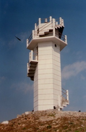
1993 (station established 1964). Active; focal plane 45 m (148 ft); two white flashes every 6 s. 12.5 m (41 ft) hexagonal cylindrical concrete tower with gallery, covered with white ceramic tiles. An external stairway winds around the tower. MSA's photo is at the top of this page, a distant street view from the mainland is available, and Google has a satellite view. Note that there is another Jiànyǔ light in Quánzhōu. Located on a small island off the southeast tip of the Dàitóu peninsula, about 7 km (4 mi) southeast of Pínghǎi. Accessible only by boat. Site status unknown. CN-3052; Admiralty P3627.9; NGA 19139.5.

Méizhōudǎo Area Lighthouses
Méizhōu Bay is the commercial harbor of Pútián. The harbor is sheltered on the east side by the island of Méizhōudǎo and the peninsula of Dōngbùzhèn.

Chìyǔshān (Chìyǔ Shān)
Date unknown. Active; focal plane 33.5 m (110 ft); white flash every 2 s. 8 m (26 ft) round concrete tower, colored with green and white horizontal bands. No closeup photo available but C.P. Wang has a very distant view (light atop island left of center) and Google has an indistinct satellite view. Located on an islet about 800 m (1/2 mi) east of the northern tip of Méizhōudǎo. Accessible only by boat. Site open, tower closed. CN-3056.5; Admiralty P3627.78; NGA 19139.1.
Xiǎodìngyǔ (Xiǎodìng Yǔ)
Date unknown. Active; focal plane 23 m (75 ft); three white flashes every 10 s. 6.5 m (21 ft) round steel tower, colored with black and white horizontal bands. No photo available but Google has an indistinct satellite view. Located on an islet about 2.5 km (1.5 mi) southeast of the northern tip of Méizhōudǎo. accessible only by boat. Site open, tower closed. CN-3056.6; Admiralty P3627.79.
Dàdèngyǔ (Ta-tien Hsu, Sorrel Rock) (3)
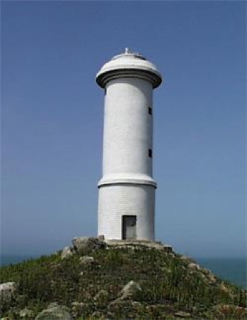
1993 (station established 1961). Active; focal plane 28 m (92 ft); white flash every 5 s. 13 m (43 ft) round cylindrical concrete tower with gallery, covered with white ceramic tiles. MSA's photo is at right but the reef is only a blur in Google's satellite view. Located on an isolated islet in the Formosa Strait about 5 km (3 mi) east of Méizhōudǎo. Accessible only by boat. Site and tower closed. CN-3058; Admiralty P3627.82.
Dadengyu Light
Dàdèngyǔ Light, Pútián
PRC MSA Shànghǎi Region photo
Éguānjiǎo (Goose Head Point, Rogues Point) (1)
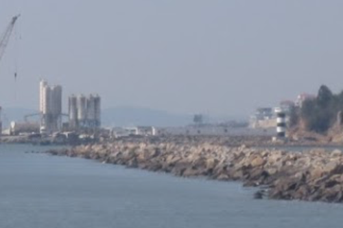
Date unknown. Inactive. Approx. 20 m (66 ft) round tower with lantern and gallery. Henry Wong has a distant view from a nearby beach (a portion is seen at right), Zhang Hongqing has a distant view, and Google has an indistinct satellite view. In colonial times this cape was called Rogues Point because it was the location of a pirate hangout. Located on the heights at the southern tip of Méizhōudǎo. Site status unknown.
Éguānjiǎo (Goose Head Point) (2)
Date unknown. Active; focal plane 22 m (72 ft); three white flashes every 10 s. 6.5 m (22 ft) tower colored with red and white horizontal bands. A very distant view is available (light is above the rocks in the upper right corner) and Google has a satellite view. Located at the southern tip of Méizhōudǎo. Site status unknown. CN-3061.7; Admiralty P3627.77.

Méizhōu Bay Entrance Lighthouses
Liùěrduō
Date unknown. Active; focal plane 8 m (26 ft); two white flashes every 6 s. 6 m (20 ft) round concrete tower, colored white. No photo available and the light is not shown in Google's satellite view. This light and the next one are on the east side of the Méizhōu Bay entrance channel. Located on a reef about 8 km (5 mi) southwest of Méizhōudǎo. Accessible only by boat. Site open, tower closed. CN-3061.8; Admiralty P3627.76.
Píngyǔ (Píng Yǔ)
Date unknown. Active; focal plane 21.5 m (64 ft); three white flashes every 10 s. 8 m (26 ft) round cylindrical concrete tower colored with red and white horizontal bands. No photo available but Google has a satellite view. Located on an islet in the center of the entrance to Méizhōu Bay. Accessible only by boat. Site open, tower closed. CN-3061.5; Admiralty P3627.765.

Éguānjiǎo Light, Pútián, April 2019
Google Maps photo by Henry Wong
Fǎngluóduō
Date unknown. Active; focal plane 9 m (30 ft); white flash every 4 s. 10 m (33 ft) round concrete tower, painted white. No photo available but Bing has a satellite view. Located on a reef about 1 km (0.6 mi) west of the southern tip of Méizhōudǎo. Accessible only by boat. Site open, tower closed. CN-3061.6; Admiralty P3627.767.
Luógōngduō
Date unknown. Active; focal plane 6 m (20 ft); two white flashes every 6 s. 6 m (20 ft) round concrete tower, painted white. No photo available but Bing has a distant satellite view. Located on a reef halfway between Dàzhúdǎo and Méizhōudǎo. Accessible only by boat. Site open, tower closed. CN-3060.06; Admiralty P3627.624.

Dōngbùzhèn Lighthouses
Pányǔ Běi (Pán Yǔ North)
Date unknown. Active; focal plane 15 m (49 ft); three white flashes every 10 s. 6 m (20 ft) round concrete tower, colored white. No photo available but Google has a distant satellite view. Located on the northeastern tip of an island just off the southern tip of the Dōngbùzhèn peninsula. Accessible only by boat. Site open, tower closed. CN-3059.6; Admiralty P3627.644.
Ménxiáyǔ (Ménxiá Yǔ)
Date unknown. Active; focal plane 12 m (39 ft); white flash every 4 s. 8.5 m (28 ft) round cylindrical concrete tower painted with black and white horizontal bands. A distant view is at right and Google has a satellite view. Located on an island in a harbor at the southern tip of the Dōngbùzhèn peninsula. Accessible only by boat. Site and tower closed. CN-3059.55; Admiralty P3627.65.
#Yāndūnshānxī (Yāndūn Shān West)
Date unknown. Apparently removed. 6 m (20 ft) round concrete tower, colored white. No photo available and the light is not seen in Google's satellite view. Located on a skerry off the harbor of Dōngbùzhèn. Accessible only by boat. Site open, tower closed. ex-CN-3059.5; ex-Admiralty P3627.645.

Upper Méizhōu Bay Lighthouses
Xīwūshíduō (Xīwūdǎo, Wushi Reef) (2)
1969 (station established 1956). Active; focal plane 12 m (39 ft); white flash every 4 s. 11 m (36 ft) hexagonal cylindrical tower covered with white tile. (The light appears to rise from a the remains of an older tower, probably the base of the original lighthouse). No photo available but Google has a satellite view. Located on a rocky reef north of the harbor of Dōngbùzhèn. Accessible only by boat. Site and tower closed. CN-3059; Admiralty P3627.66.

Ménxiáyǔ Light, Pútián, January 2014
Google Maps photo by 海狼王 (Sea Wolf King)
Dàshāndǐng (?)
Date unknown. Active; focal plane 6 m (20 ft); white flash every 4 s. 6 m (20 ft) round concrete tower, colored white. No photo available and the light is not seen in Google's satellite view. Recent development suggests this light may have been removed or relocated. Located on the northeastern tip of an island east of Huìyǔ. Accessible only by boat. Site open, tower closed. CN-3056.2; Admiralty P3627.695.
Xiùyǔ LNG East Pier
Date unknown. Active; focal plane 16 m (52 ft); green light, 1 s on, 1 so off. 10 m (33 ft) round barbell-shaped fiberglass tower colored with red and white horizontal bands. This light is at the far left in Sū Jiànfā's photo and Google has an indistinct satellite view. Located at the east end of the Xiùyǔ LNG terminal. Site and tower closed. CN-3055.01; Admiralty P3627.751.
Xiùyǔ LNG West Pier
Date unknown. Active; focal plane 16 m (52 ft); green light, 2 s on, 2 so off. 10 m (33 ft) round barbell-shaped fiberglass tower colored with red and white horizontal bands. This light is in the foreground in Sū Jiànfā's photo and Google has an indistinct satellite view. Located at the west end of the Xiùyǔ LNG terminal. Site and tower closed. CN-3055.02; Admiralty P3627.7515.

Information available on lost lighthouses:

Notable faux lighthouses:

Adjoining pages: North: Píngtán Area | East: Matsu and Kinmen | South: Quánzhōu

Return to the Lighthouse Directory index | Ratings key

Posted July 28, 2008. Checked and revised January 26, 2024. Lighthouses: 27. Site copyright 2024 Russ Rowlett and the University of North Carolina at Chapel Hill.