Lighthouses of China: Píngtán Area, Fújiàn

China, officially Zhōngguó (中华), has been the largest and most dominant nation of East Asia since it was unified under a single emporer in 221 BCE. However imperial power waned during the nineteenth century, allowing European colonial powers to enter the country. Britain, France, Portugal, Germany, and Russia all established outposts in China. European engineers developed Chinese ports and built the first Western lighthouses, many of which remain in service today. After the imperial government was overthrown in 1912 China entered a long period of instability. The civil war between republican and Communist forces began in 1927. In 1937 Japan invaded, occupying large parts of China and starting a war that merged with World War II. After that war ended in 1945 civil war resumed and by 1949 the Communists achieved control of the entire mainland, the republicans retreating to the island of Taiwan.

Today the People's Republic of China (PRC) has a lengthy coastline, many large harbors, and a large number of lighthouses. The country is divided into 22 provinces and 11 other province-level regions of various special types. The province of Fújiàn (formerly spelled Fukien or Fuchien) is located on the southeastern coast of the country facing Taiwan across the Taiwan Strait. The coastline is rugged and irregular with many islands and reefs threatening unwary navigators. Many bays cut deeply into the mainland.

Fújiàn is divided into nine prefectural-level cities, six of them facing the coast. This page includes lighthouses of Píngtán County and Fúqīng City in the southern part of the prefectural level city of Fúzhōu. Píngtán County includes the large island of Hǎitándǎo (also called Píngtán Island) and many smaller islands off the Fújiàn coast.

There are many languages and dialects spoken in China, but Standard Chinese, often called Mandarin, is official. The pīnyīn system for transliterating Standard Chinese into Latin characters is now the international standard but some locations continue to be known also under the spellings of older transliteration systems. The Chinese word for a lighthouse is dēngtǎ (灯塔). In Standard Chinese jiāo (formerly chiao) is a reef or rock, jiǎo is a cape or headland, dǎo (tao) is an island; (tsu) or tuózi ("lump") is a small island, hǎi is a sea, wān is a bay, hǎixiá is a strait, or jiāng is a river, hékǒu ("river mouth") is an estuary, and gǎng (kang) is a harbor.

Lighthouses in China are maintained by the PRC Maritime Safety Administration. The administration is organized in four regional administrations, with district offices in the major ports. All the lights on this page are maintained by the Fúzhōu MSA office, which is part of the Shànghǎi Region.

ARLHS numbers are from the ARLHS World List of Lights. CN numbers are the MSA List of Lights (助航标志表) numbers. Admiralty numbers are from volume P of the Admiralty List of Lights & Fog Signals. U.S. NGA List numbers are from Publication 112.

General Sources
Online List of Lights - China
Photos by various photographers posted by Alexander Trabas.
Chinese English Pinyin Dictionary
A useful tool for juggling the representations of Chinese names.
Navionics Charts
Navigation chart for the Píngtán area.
 

Niushandao Light
Niúshāndǎo Light, Píngtán County
photo posted by Píngtán County government

Píngtán County East Side Lighthouses

Northeast Coast (Taiwan Strait Entrance) Lighthouses

Zhúpǎiyǔ
Date unknown. Active; focal plane 17 m (56 ft); two white flashes every 6 s. 8 m (26 ft) round concrete tower colored with red and white horizontal bands. No photo available but Google has an indistinct satellite view. Located on a small island about 13 km (8 mi) northwest of the northernmost peninsula of Hǎitándǎo. Accessible only by boat. Site and tower closed. CN-2985.1; Admiralty P3633.32.
Báitóudǎo (Báitóu Dǎo, Bald Island, Waif Rock)
2009. Active; focal plane 22 m (72 ft); white flash every 4 s. 8 m (26 ft) round concrete tower colored with red and white horizontal bands. No photo available but Google has an indistinct satellite view. Located on a small island about 8 km (5 mi) off the northernmost peninsula of Hǎitándǎo. Accessible only by boat. Site and tower closed. CN-2985.3; Admiralty P3633.315.
Shānbaídǎo (White Mountain Island)
Date unknown. Active; focal plane 38 m (126 ft); two white flashes every 6 s. 8 m (26 ft) round concrete tower colored with red and white horizontal bands. No photo available but Google has an indistinct satellite view. Located on a small island about 15 km (9 mi) northeast of the northernmost peninsula of Hǎitándǎo. Accessible only by boat. Site and tower closed. CN-2985.5; Admiralty P3633.29.
Jùnshāndǎo (Jùnshān Dǎo)
Date unknown. Active; focal plane 41 m (135 ft); two white flashes every 6 s. 8 m (26 ft) round concrete tower, colored with red and white horizontal bands. No photo available but Google has a satellite view. Located on a small island about 1 km (0.6 mi) off the northernmost peninsula of Hǎitándǎo. Accessible only by boat. Site and tower closed. CN-2987.1; Admiralty P3633.31.
Xiángjiǎo (Xiáng Jiǎo)
Date unknown. Active; focal plane 63 m (207 ft); two white flashes every 6 s. 11 m (36 ft) hexagonal concrete tower colored with red and white horizontal bands. No photo available but Google has a satellite view. Located on the northern tip of Hǎitándǎo. Site status unknown. CN-2986.5; Admiralty P3633.305.
Dōngxiángdǎo (Dōngxiáng Dǎo, Tung-hsiang Tao)
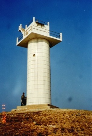
1989 (heightened in 1998). Active; focal plane 49 m (161 ft); three white flashes every 10 s. 17 m (56 ft) round cylindrical concrete tower with gallery, covered with ceramic tile in black and white horizontal bands. A photo is at right and Bing has a satellite view. Located on the northeastern tip of Dōngxiáng Dǎo, an inhabited island off the east coast of Hǎitándǎo. Site status unknown, possibly accessible. CN-2988; Admiralty P3632.5; NGA 19134.
Xiǎoxiàlǐjiāo (Xiǎoxiàlǐ Jiāo)
2012. Active; focal plane 8 m (26 ft); white flash every 4 s. 9 m (30 ft) round cylindrical concrete tower, covered with white ceramic tile. No photo available but Google has a satellite view. Located on a shoal between Dongxiangdao and the east coast of Hǎitándǎo. Accessible only by boat. Site status unknown. CN-2988.01; Admiralty P3632.6.

Dōngxiángdǎo Light, Píngtán County
unattributed photo formerly posted by sinaimg.cn

Southeast Coast (Taiwan Strait) Lighthouses
Xiǎoshāyǔ (Xiǎoshā Yǔ)
Date unknown. Active; focal plane 30 m (98 ft); white flash every 4 s. 8 m (26 ft) square cylindrical concrete tower, colored with black and white horizontal bands. No photo available but Bing has an indistinct satellite view. Located on a small island just off the southeastern tip of Hǎitándǎo. Accessible only by boat. Site status unknown. CN-2989.5; Admiralty P3632.3; NGA 19135.
Niúshāndǎo (Niúshān Dǎo, Turnabout Island) (4?)
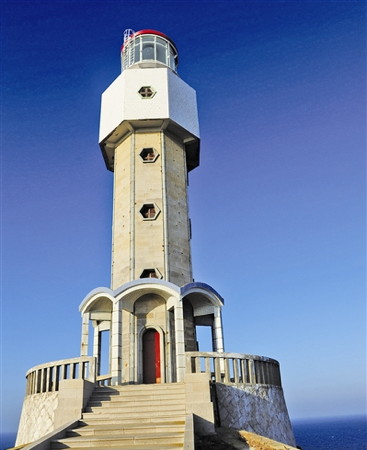
1987 (station established 1873). Active; focal plane 90 m (295 ft); two white flashes every 12 s. 23.5 m (77 ft) octagonal cylindrical stone tower with lantern and gallery. The tower is covered with ceramic tile, described as white in the light lists, but in the photo at the top of this page the tower is light brown and the gallery white. Lantern dome painted red. The county government formerly had a page for the lighthouse that included the photo at the top of this page, there's another page for the lighthouse, the Fujian TV network has a story on the lighthouse, and Google has a satellite view of the station. The original lighthouse was a 16.5 m (54 ft) stone tower designed by British engineers; the University of Bristol has a historic photo. The lighthouse was destroyed in the Sino-Japanese War of 1894-95. The second (1899) lighthouse, probably similar and described as a "circular black tower," was destroyed during World War II. A temporary light was installed in 1947. The lighthouse was rebuilt or replaced in December 1982, five years before the current lighthouse was built. Historically this light station is an important guide for ships passing through the Taiwan (Formosa) Strait, marking the west side of the northern entrance to the strait. Located on Niúshān Island about 10 km (6 mi) southeast of Hǎitándǎo. Accessible only by boat. Site status unknown. CN-2989; Admiralty P3632; NGA 19136.
Báijiāngdǎo (Báijiāng Dǎo)
Date unknown. Active; focal plane 22 m (72 ft); two white flashes every 6 s. 9 m (30 ft) round concrete tower, colored with red and white horizontal bands. No photo available but Google has a distant satellite view. Located on a small island about 8 km (5 mi) northeast of the southern tip of Hǎitándǎo. Accessible only by boat. Site status unknown. CN-2991.1; Admiralty P3632.9.
* Hǎitánjiǎo Xīnán (Hǎitánjiǎo Southwest)
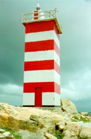
1989. Active; focal plane 36 m (118 ft); three white flashes every 10 s. 10.5 m (35 ft) square stone tower with gallery. Lighthouse covered with ceramic tile colored with red and white horizontal bands. MSA's photo is at right and Google has an indistinct satellite view. Located at the southern tip of Hǎitándǎo. This location is probably accessible by road. Site may be open, tower closed. CN-2992; Admiralty P3633.
Dàizhōngjiāoyǔ (Dàizhōngjiāo Yǔ)
Date unknown. Active; focal plane 13 m (43 ft); two white flashes every 6 s. 8 m (26 ft) square concrete tower colored with black and white horizontal bands. No photo available but Google has an indistinct satellite view. Located on an islet off the southern tip of Hǎitándǎo. Accessible only by boat. Site open, tower closed. CN-2992.5; Admiralty P3633.02.
Haitanjiaoxinan Light
Hǎitánjiǎo Xīnán Light
PRC MSA Shànghǎi Region photo

Píngtán County West Side (Hǎitán Strait) Lighthouses

Hǎitán (Píngtán) Island is about 30 km (19 mi) long north to south and roughly 15 km (9 mi) wide. It is separated from the mainland by the Hǎitán Strait (Hǎitánxiá), an irregular waterway 6-10 km (4-6 mi) wide. Since 2010 a bridge has connected the island to the mainland. A second bridge carrying both road and rail traffic was completed in late 2020.

Hǎitán Strait Northern Entrance Lighthouses
Dàliàndǎo Dōng (Dalian Dao East)
Date unknown. Active; focal plane 17 m (56 ft); white flash every 4 s. 8 m (26 ft) concrete tower painted with black and white horizontal bands. No photo available but Google has an indistinct satellite view. Located on the southeastern tip of Dàliàndǎo on the north side of the Hǎitán Strait. Site status unknown. CN-3002.3; Admiralty P3633.395.
Zhōngyǔ (Zhōng Yǔ, Bell Island) (2)
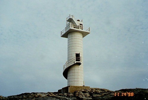
1998 (station established 1958). Active; focal plane 27.5 m (90 ft); red flash every 4 s. 12 m (39 ft) round cylindrical concrete tower with gallery, covered with white ceramic tile. An MSA photo is at right and Google has a satellite view. Located on an island in the narrow channel between the islands of Dàliàndǎo and Hǎitándǎo. Accessible only by boat. Site and tower closed. CN-3003.
Lǎoniújiāo (Lǎoniú Jiāo)
Date unknown. Active; focal plane 7 m (23 ft); two white flashes every 6 s. 8 m (26 ft) hexagonal concrete tower painted with red and white horizontal bands. No photo available but Bing has a distant satellite view. Located on a reef about 3 km (2 mi) southwest of Dàliàndǎo. Accessible only by boat. Site open, tower closed. CN-3004.7; Admiralty P3633.392.
Gǔyǔ (Gǔ Yǔ, Ku Hsu, Drum Island) (2)
1995 (station established 1954). Active; focal plane 33 m (108 ft); two white flashes every 4 s. 12.5 m (41 ft) square cylindrical concrete tower with gallery, covered with white ceramic tile. No photo available but Google has a satellite view. Located on a small island at the northern end of the Hǎitán Strait. Accessible only by boat. Site and tower closed. CN-2996; Admiralty P3633.4; NGA 19133.6.
Qījiěmèijiāo (Qījiěmèi Jiāo, Seven Sisters Reef) (2)
1995 (station established 1954). Active; focal plane 11 m (36 ft); four white flashes every 10 s. 15 m (49 ft) hexagonal cylindrical concrete tower with gallery, covered with red ceramic tile. No photo available but Bing has a satellite view. Located on a dangerous reef in the northern Hǎitán Strait, about 3 km (2 mi) east of the island of Yǔtóudǎo. Accessible only by boat. Site and tower closed. CN-2997; Admiralty P3633.38.
Dàliàndǎo Xījiāo (Dàliàndǎo West Reef, Dinggai Jiao)
Date unknown. Active; focal plane 9 m (30 ft); white flash every 4 s. 10 m (33 ft) square concrete tower painted with red and white horizontal bands. No photo available but Google has a satellite view. Located on a reef about 1.6 km (1 mi) west of Dàliàndǎo. Accessible only by boat. Site open, tower closed. CN-2998; Admiralty P3633.39.
Qīngjiāoyǔ (Green Reef Island) (2)
Date unknown. Active; focal plane 18.5 m (61 ft); two white flashes every 6 s. 8.5 m (28 ft) concrete tower colored with red and white horizontal bands. No photo available but Bing has a fuzzy satellite view. Located on an island about 500 m (1/3 mi) southeast of the Dàliàndǎo Xījiāo lighthouse. Accessible only by boat. Site and tower closed. CN-3004.5: Admiralty P3633.393.

Zhōngyǔ Light, November 1998
PRC MSA Shànghǎi Region photo

Northern Hǎitán Strait Lighthouses
Tǎyán Xījiāo (Chijiao Yu) (2)
1998 (station establishment date unknown). Active; focal plane 13 m (43 ft); white flash every 3 s. 15 m (49 ft) square cylindrical concrete tower with gallery, covered with white ceramic tile. No photo available but Bing has a fuzzy satellite view. Located on a reef in the middle of the Hǎitán Strait, about 8 km (5 mi) southwest of Dàliàndǎo. Accessible only by boat. Site and tower closed. CN-3005; Admiralty P3633.391.
[Shíbēicǎoyǔ (Shíbēicǎo Yǔ, Shipaicao Yu, Standing Stone Island)]
Date unknown. Active; focal plane 13 m (43 ft); white flash every 4 s. 8 m (26 ft) post painted with red and white horizontal bands. This reef is famous for a large stone that stands upright. The light is in the left distance in a photo of the stone and Google has an indistinct satellite view. Located on a reef about 800 m (1/2 mi) off the northwestern corner of Hǎitándǎo. Accessible only by boat. Site status unknown. CN-3005.5; Admiralty P3633.399.
Cuìyán (Panyang Jiao) (2)
1993 (station establishment date unknown). Active; focal plane 11 m (36 ft); three white flashes every 6 s. 12.5 m (41 ft) square cylindrical concrete tower with gallery, covered with red ceramic tile. No photo available but Bing has a satellite view. Located on a reef in the middle of the Hǎitán Strait, about 8 km (5 mi) off the west coast of Hǎitándǎo. Accessible only by boat. Site and tower closed. CN-3006; Admiralty P3633.397.
Luóhòubíyǔ (Luóhòubí Yǔ)
Date unknown. Active; focal plane 31.5 m (103 ft); two white flashes every 6 s. 8.5 m (28 ft) round cylindrical concrete tower covered with tile colored in black and white horizontal bands. No photo available but Bing has a satellite view. Located on an islet off the southwest coast of Hǎitándǎo. Accessible only by boat. Site and tower closed. CN-3015.5; Admiralty P3633.285.
Hǎitán Hóuyǔ (Hóu Yǔ, Monkey Island)
Date unknown. Active; focal plane 44 m (144 ft); white flash every 5 s. 8.5 m (28 ft) round cylindrical concrete tower, colored with red and white horizontal bands. No photo available but Google has an indistinct satellite view. Located on the west side of an island off the southwest coast of Hǎitándǎo. Accessible only by boat. Site status unknown. CN-3016.5; Admiralty P3633.283.
Wūtáiyǔ (Wūtái Yǔ) (2)
2001 (station established 1956). Active; focal plane 12 m (39 ft); three white flashes every 10 s. 11 m (36 ft) round cylindrical concrete tower with gallery, covered with ceramic tile colored white with red trim. No photo available but Google has an indistinct satellite view. The original lighthouse was an 8 m (26 ft) pyramidal tower. Located on a reef about 1 km (0.6 mi) southwest of the Hóuyǔ lighthouse. Accessible only by boat. Site and tower closed. CN-3017; Admiralty P3633.282.
Fēnliúwěi (2)
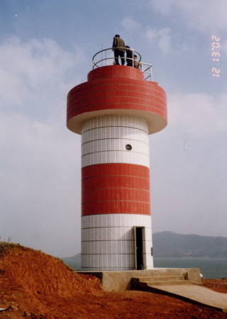
2002 (station established 1956). Active; focal plane 25 m (82 ft); white flash every 4 s. 9.5 m (31 ft) round cylindrical concrete tower with gallery, covered with ceramic tile colored with red and white horizontal bands. The MSA photo is at right and Google has a satellite view. The original lighthouse was an 8 m (26 ft) tower. Located on an islet in the center of the Hǎitán Strait about 3 km (2 mi) south of the Wūtáiyǔ Light. Accessible only by boat. Site and tower closed. CN-3018; Admiralty P3633.28.
Fenliuwei Light
Fēnliúwěi Light, Píngtán, December 2002
PRC MSA Shànghǎi Region photo

Southern Hǎitán Strait Lighthouses
Niánggōng
Date unknown.Active; focal plane 11.5 m (38 ft); four white flashes every 12 s. 7 m (23 ft) concrete tower colored with black and white horizontal bands. No photo available but Google has a satellite view. Located on a short pier just south of the eastern end of the Píngtán Bridge. Site status unknown. CN-3018.03; Admiralty P3633.278.
Jīnxúnjiāo (Jīnxún Jiāo, Wángjǐngjiāo) (3)
1992 (station established 1956). Active; focal plane 10 m (33 ft); two white flashes every 5 s. 12 m (39 ft) hexagonal cylindrical concrete tower with gallery, painted black with one red horizontal band. No photo available but Google has a satellite view. Located on a reef in the Hǎitán Strait, about 400 m (1/4 mi) northeast of Dà Yǔ (next entry). Accessible only by boat. Site and tower closed. CN-3019; Admiralty P3632.7.
Dà Yǔ
Date unknown. Active; focal plane 27 m (89 ft); three white flashes every 10 s. 7 m (23 ft) round concrete tower colored with red and white horizontal bands. No photo available but Google has a satellite view. Located on an island about 2 km (1.25 mi) south of the Píngtán Bridge. Accessible only by boat. Site status unknown. CN-3019.1; Admiralty P3632.8.
Dāojiàyǔ (Dāojià Yǔ)
Date unknown. Active; focal plane 9 m (30 ft); white flash every 6 s. 7 m (23 ft) hexagonal concrete tower colored with red and white horizontal bands. No photo available but Google has an indistinct satellite view. Located on a rock off the southwest coast of Hǎitándǎo. Accessible only by boat. Site open, tower closed. CN-3019.5; Admiralty P3632.85.

Southern Islands Lighthouses
Cǎoyǔ (Cǎo Yǔ, Grass Island)
Date unknown. Active; focal plane 48 m (158 ft); two white flashes every 8 s. 14 m (46 ft) round cylindrical concrete tower colored with red and white horizontal bands. No photo available but Google has a satellite view. Located on a headland at the eastern tip of Cǎoyǔ island, an island about 6 km (3.5 mi) south of Hǎitándǎo. Accessible only by boat. Site status unknown. CN-3020.43; Admiralty P3633.185; NGA 19136.2.
Gāoyǔ (Gāo Yǔ, High Island) (2?)
Date unknown. Active; focal plane 20 m (66 ft); white flash every 4 s. 8 m (26 ft) round concrete tower, colored with red and white horizontal bands. No photo available but Google has a distant satellite view. Located at the northwest end of an island at the south end of the Hǎitán Strait. Accessible only by boat. Site and tower closed. CN-3020.4; Admiralty P3633.19.
Běiguānyǔ (Běiguān Yǔ)
Date unknown. Active; focal plane 13 m (43 ft); two white flashes every 6 s. 7 m (23 ft) hexagonal concrete tower colored with black and white horizontal bands. No photo available and the tower is hard to find in Google's satellite view. Located on the northern point of an island off the northwest side of Tángyǔ. Accessible only by boat. Site status unknown. CN-3020.6; Admiralty P3633.12.
Nánlùsī (2)
1998 (station established 1956). Active; focal plane 18 m (59 ft); three white flashes every 10 s. 14.5 m (48 ft) round cylindrical concrete tower with gallery, covered with white ceramic tile. MSA's photo is at right and Bing has a fuzzy satellite view. Located on an islet off the west coast of the island of Tángyǔ, at the southern entrance to the Hǎitán Strait. Accessible only by boat. Site and tower closed. CN-3021; Admiralty P3633.1.
Nanlusi Light
Nánlùsī Light, Píngtán, November 1998
PRC MSA Shànghǎi Region photo
Xiǎojiǎdǎo
Date unknown. Active; focal plane 22 m (72 ft); two white flashes every 6 s. 8 m (26 ft) square concrete tower colored with black and white horizontal bands. No photo available but Bing has an indistinct satellite view. Located on an islet about 7 km (4 mi) southeast of Cǎoyǔ. Accessible only by boat. Site status unknown. CN-3022.05; Admiralty P3633.025; NGA 19136.7.
Nánhéngdǎo (Nánhéng Dǎo, Southern Cross Island)
Date unknown. Active; focal plane 13 m (43 ft); white flash every 4 s. 7 m (23 ft) hexagonal concrete tower colored with red and white horizontal bands. No photo available but Google has an indistinct satellite view. Located on an islet about 6 km (3.5 mi) southeast of Tángyǔ. Accessible only by boat. Site status unknown. CN-3022.02; Admiralty P3633.03; NGA 19136.8.

Fúqīng City (Xīnghuà Bay Area) Lighthouses

Hǎitán Strait West Side Lighthouses
Xiǎoshāndōng (Xiaoshan East)
Date unknown. Active; focal plane 8 m (26 ft); two white flashes every 8 s. 7 m (23 ft) hexagonal concrete tower colored with red and white horizontal bands. Chen Huang has a photo (a portion is seen at right) and Google has a satellite view. Located at the end of the former ferry pier at Xiǎoshān, on the Hǎitán Strait just south of the Hǎixiǎ bridge to Hǎitándǎo. Site status unknown. CN-3018.05; Admiralty P3633.275.
Dōngjìndǎo (Dōngjìn Dǎo) (2)
1996 (station established 1956). Active; focal plane 23 m (85 ft); two white flashes every 4 s. 10 m (33 ft) square cylindrical concrete tower with gallery, covered with white ceramic tile. No photo available but Google has a satellite view. Located on a small island on the west side of the southern entrance to the Hǎitán Strait. Accessible only by boat. Site and tower closed. CN-3020; Admiralty P3633.27.
Fǎngchējiāo (Fǎngchē Jiāo, Fangshejiao)
Date unknown. Active; focal plane 10 m (33 ft); white flash every 4 s. 7 m (23 ft) hexagonal concrete tower colored with black and white horizontal bands. No photo available but Google has a satellite view. Located on a reef off the southeastern corner of the Xīnghuà Peninsula. Accessible only by boat. Site status unknown. CN-3020.5; Admiralty P3633.13.
Dōngjiànyǔ (Dōngjiàn Yǔ)
2011. Active; focal plane 20 m (66 ft); two white flashes every 6 s. 8 m (26 ft) round concrete tower. Lighthouse covered with ceramic tile colored with red and white horizontal bands. No photo available but Google has an indistinct satellite view. Located on a skerry on the north side of the entrance to the Xīnghuà Channel, which leads into Xīnghuà Bay. Accessible only by boat. Site status unknown. CN-3020.51; Admiralty P3633.14.

Xiǎoshāndōng Light, Fúqīng, October 2009
Google Maps photo by Chen Huang

Xīnghuà Bay Lighthouses
Liánlǐng
Date unknown. Active; focal plane 32 m (105 ft); white flash every 3 s. 6 m (20 ft) round stone tower, painted white. No photo available but Google has a satellite view. Located at the southwestern tip of the Xīnghuà Peninsula. Site status unknown. CN-3030; Admiralty P3633.18.
Báiyǔ (Bái Yǔ, Báifú, White Rock) (2)
1990 (station established 1956). Active; focal plane 36 m (118 ft); two white flashes every 6 s. 9 m (30 ft) round concrete tower, painted white. No photo available but Google has a satellite view. Located on a small island on the north side of the Xīnghuà Channel. Accessible only by boat. Site status unknown. CN-3031; Admiralty P3633.15; NGA 19136.4.
Shānyǔ (Shān Yǔ)
Date unknown. Active; focal plane 13 m (43 ft); white flash every 3 s. 8 m (26 ft) round white concrete tower. No photo available but Google has a satellite view. Located on a small island off the southwest end of the island of Guòyǔ. Accessible only by boat. Site status unknown. CN-3034; Admiralty P3633.1725.
Chìshānyǔ (Chìshān Yǔ)
Date unknown. Active; focal plane 18 m (59 ft); three white flashes every 10 s. 7 m (23 ft) hexagonal concrete tower colored with black and white horizontal bands. No photo available and the tower is hard to see in Google's satellite view. Located on a reef about halfway between Shanyu and Mùyǔ. Accessible only by boat. Site status unknown. CN-3034.5; Admiralty P3633.172.
Báijiāoyǔ (Báijiāo Yǔ)
Date unknown. Active; focal plane 23 m (75 ft); two white flashes every 6 s. 7 m (23 ft) hexagonal concrete tower colored white. No photo available but Google has a satellite view. Located on a skerry about 1.2 km (3/4 mi) west of Chishanyu. Accessible only by boat. Site status unknown. CN-3034.505; Admiralty P3633.171.
Mùyǔběi (Mu Yu North)
Date unknown. Active; focal plane 20 m (66 ft); four white flashes every 12 s. 8 m (26 ft) white concrete tower. The light is barely visible in Zhiqing Yang's distant view (on the island right of center) and Google has an indistinct satellite view. Located at the northeastern tip of Mùyǔ, an island off the southwestern tip of the Xīnghuà Peninsula. Accessible only by boat. Site status unknown. CN-3034.605; Admiralty P3633.173.
Xīnghuà Wān Zhōngyǔ (Zhong Yǔ, Jīdàn Dǎo) (3)
1996 (station established 1954). Active; focal plane 34.5 m (113 ft); three white flashes every 10 s. 9.5 m (31 ft) hexagonal cylindrical concrete tower with gallery, covered with white ceramic tiles. An external stairway winds around the tower. No photo available but Google has a satellite view. Located on a small island on the south side of the Xīnghuà Channel. Accessible only by boat. Site status unknown. CN-3032; Admiralty P3633.16.
Lùyǔ Nánjiāo (Lù Yǔ South Reef, Lùdǎo South Reef)
Date unknown. Active; focal plane 10 m (33 ft); white flash every 6 s. 11 m (36 ft) round cylindrical concrete tower with gallery, covered with ceramic tiles colored in red and white horizontal bands. An MSA photo is at right and Google has a satellite view. Located on a rocky reef on the south side of the island of Mùyǔ, about 2 km (1.25 mi) northwest of the Xīnghuà Wān Zhōngyǔ light. Accessible only by boat. Site status unknown. CN-3033; Admiralty P3633.17; NGA 19136.5.
Tuǐyǔ (Tuǐ Yǔ)
2010(?). Active; focal plane 25 m (82 ft); three white flashes every 10 s. 8 m (26 ft) round white concrete tower. No photo available but Bing has an indistinct satellite view. Located on a small island about 1 km (0.6 mi) northwest of Mùyǔ. Accessible only by boat. Site status unknown. CN-3034.705; Admiralty P3633.1735.
Niú'ěryǔ (Niú'ěr Yǔ)
Date unknown. Active; focal plane 20 m (66 ft); two white flashes every 6 s. 7 m (23 ft) hexagonal concrete tower colored with black and white horizontal bands. No photo available and the light is not seen in Google's satellite view. Located on a reef about 1.2 km (3/4 mi) north of the Tuiyu light. Accessible only by boat. Site status unknown. CN-3034.7; Admiralty P3633.174.

Information available on lost lighthouses:

Notable faux lighthouses:


Lùyǔ Nánjiāo Light, Fúqīng
PRC MSA Shànghǎi Region photo

Adjoining pages: North: Fúzhōu | East: Matsu and Kinmen | South: Pútián

Return to the Lighthouse Directory index | Ratings key

Posted July 7, 2008. Checked and revised January 19, 2024. Lighthouses: 51. Site copyright 2024 Russ Rowlett and the University of North Carolina at Chapel Hill.