Lighthouses of Northern Mozambique

The Republic of Mozambique (Moçambique in Portuguese) is located on the southeastern coast of Africa bordering Tanzania to the north and South Africa to the south. The country was a Portuguese colony from the early sixteenth century until it achieved independence in 1975. Independence was followed by a long and bitter civil war that ended in 1992. Since then increased stability has improved the country's economic situation and opened it to foreign visitors.

Mozambique has the longest coastline of any continental African country, more than 2500 km (1565 mi) in length, facing the island of Madagascar across the Mozambique Channel. The major ports are Pemba in the north, Quelimane and Beira in the center, and Maputo (the capital) in the far south. Mozambique is divided into 10 provinces plus the capital district. This page includes lighthouse in the northern half of the country in the provinces of Cabo Delgado, Nampula, and Zambezia. The Zambezi River provides a natural border between northern and southern halves of Mozambique.

Portuguese continues as the language of government and trade in Mozambique. The Portuguese word for a lighthouse is farol, plural faróis; a small lightbeacon is often called a farolim. In Portuguese ilha is an island, ilhéu is an islet, cabo is a cape, ponta is a promontory or point of land, rocha is a rock, recife is a reef, baía is a bay, estreito is a strait, rio is a river, and porto is a port or harbor.

Aids to navigation in Mozambique are the responsibility of the National Institute of Hydrography and Navigation (INAHINA).

ARLHS numbers are from the ARLHS World List of Lights. Admiralty numbers are from volume D of the Admiralty List of Lights & Fog Signals. U.S. NGA List numbers are from Publication 112.

General Sources
Lighthouse Development in Mozambique, 1908-1931
The late Michel Forand contributed this resource. It includes a translation of a 1931 account of the development of coastal lights in Mozambique, with maps and photos of the lighthouses, plus additional images from Mr. Forand's collection.
Online List of Lights - Mozambique
Photos by various photographers posted by Alexander Trabas.
INAHINA - Faróis
No longer online, this site had pages for each light providing brief descriptions and historical information.
Lighthouses in Mozambique
Photos by various photographers available from Wikimedia.
World of Lighthouses - Mozambique
Photos by various photographers available from Lightphotos.net.
Afrikanische Leuchttürme auf historischen Postkarten
Postcards from the collection of Klaus Huelse.
Navionics Charts
Navigational chart information for Mozambique.

Ilha de Mafamede Light, Angoche, 2018
INAHINA photo
Cabo Delgado Province Lighthouses

Cabo Delgado Lighthouse
Cabo Delgado (2)
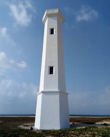
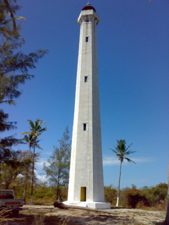
1931 (station established 1889). Active; focal plane 42 m (138 ft); two white flashes every 12 s. 36 m (118 ft) hexagonal concrete tower with lantern and gallery. Several 1-story keeper's houses. A photo is at right, Erich Koch has a closeup photo and a more distant view, and Google has a satellite view. The original lighthouse was a wood tower. The present lighthouse was rehabilitated and reactivated in 1994. Located on the cape, which is at the end of a long peninsula about 40 km (25 mi) northeast of Palma and a similar distance southeast of the Tanzanian border. Site status unknown. ARLHS MOZ-004; Admiralty D6648; NGA 31536.

Quirimbas Islands Lighthouse
The Quirimbas Islands is a string of islands along the northern coast of Mozambique extending southward from Cabo Delgada to Pemba. The islands provided trading bases, first for Arab sultanates and then for the Portuguese. Several of the islands are now locations for beach resorts.

Ilha Vamizi
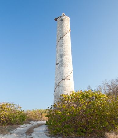
Date unknown. Inactive but listed by NGA with focal plane 13 m (43 ft); two white flashes every 6 s. 9 m (30 ft) round strongly conical white concrete tower. Endangered. A photo is available showing a lens in place but no solar panels, and the light appears completely abandoned in a November 2018 street view by Chris du Plessis. Google has a satellite view. Vamizi is a a narrow island about 15 km (9 mi) long, about 40 km (25 mi) south of Cabo Delgado. Located near the east end of the island. Accessible only by boat. Site open, tower closed. Admiralty D6647; NGA 31540.
Ilha Tambuzi (2)
1953 (station established 1934). Active; focal plane 35 m (115 ft); two white flashes every 10 s. 26 m (85 ft) round concrete tower, painted with black and white horizontal bands. Keeper's house in ruins. No photo available but Google has a good satellite view. The Admiralty reported this light to be in service in 2008. The privately-owned island was for sale in 2013. The original lighthouse was a square 18.5 m (58 ft) concrete tower, reported to be in ruins by the 1950s. Located on a small island in the Indian Ocean about 37 km (23 mi) due east of Mocímbao da Praia. Accessible only by boat. Site and tower closed. ARLHS MOZ-008; Admiralty D6642; NGA 31556.
Ilheu Quero-Niuni
Date unknown. Presumably inactive (not on INAHINA's list); listed by NGA with focal plane 9 m (30 ft); white flash every 4 s. 9 m (30 ft) square white concrete tower. No photo available and no tower is seen in Google's satellite view of the listed location. Located on a small island about 18 km (11 mi) north of Ilha Medjumbe. Accessible only by boat. Site status unknown. Admiralty D6641; NGA 31560.
Cabo Delgado Light
Cabo Delgado Light, Palma, undated
INAHINA photo
* Ilha Medjumbe (Mdjumbe) (2)
1963 (station established 1934). Apparently inactive at least since the 1980s but listed with focal plane 32 m (105 ft); two white flashes every 15 s. 26 m (85 ft) white round concrete tower. Lantern removed. Endangered by beach erosion. Although this lighthouse is listed as active by NGA and the Admiralty, Chris Chilton's May 2007 photo shows it abandoned by that time, with no lamp or other evidence of a light. Ewald De Korte's 2012 photo is at right, a 2013 photo is available, and Google has a satellite view. Medjumbe is a small island in the Quirimbas Islands about 55 km (35 mi) north of Ilha do Ibo. Located on the eastern point of the island, an easy walk from the Medjumbe Island Resort. Site open, tower closed. ARLHS MOZ-024; Admiralty D6640; NGA 31564.
Ilha do Ibo (Mujaca, Ibo Island) (3)
Date unknown (station established 1873). Inactive but listed with focal plane 18 m (59 ft); white flash every 12 s. 15 m (49 ft) square skeletal tower, mounted on a square stone base. 1-story keeper's house. Carlos Lopes Bento posted a 1971 aerial photo (no longer online); at that time there was a white round tower on top of the square base. Endangered. The present tower is dilapidated and abandoned. No photo available but Google has a satellite view of the ruined station. Ibo was a fortified Portuguese settlement during the 16th and 17th centuries. Much of the island is now included in Quirimbas National Park. Located on the northern point of the island. Site status unknown. ARLHS MOZ-007; Admiralty D6636; NGA 31568.
* Porto do Ibo
Date unknown. Active (?); focal plane 6 m (20 ft); red flash every 3 s. 6 m (20 ft) concrete post mounted on one corner of a square 1-story equipment shelter. Post painted with red and white horizontal bands, equipment shelter painted white. Marcello Spadoni has a 2011 photo; the light was not active at that time. Google has a satellite view. Located at the base of the pier at Ibo village, on the west side of the island. Site open, tower closed. Admiralty D6637; NGA 31572.
Ponta do Diabo (2)
1997. Active; focal plane 8 m (26 ft); two white flashes every 10 s. 6 m (20 ft) square cylindrical masonry tower. No photo available but Google has a satellite view. This light replaced an older and similar light toppled by strong winds and poor maintenance, according to INAHINA. Located on a low promontory about 19 km (12 mi) north of Pemba Bay. Probably accessible only by boat. Site open, tower closed. Admiralty D6634; NGA 31576.

Medjumbe Light, Cabo Delgado Province, September 2012
Wikimedia Creative Commons photo by Ewald De Korte

Pemba Area Lighthouse
Pemba, the capital of Cabo Delgado Province, is a seaport founded by Portugal in 1904 as Porto Amélia. It has a population of about 200,000.

Ponta Said Ali (2)
1930 (station established 1900). Active; focal plane 10 m (33 ft); green flash every 4 s. 8 m (26 ft) short round cylindrical tower centered on a massive square masonry base. Round tower painted red with one white horizontal band; base painted white. Lightphotos.net has a photo and a Google satellite view shows a likely keeper's house in ruins behind the lighthouse. The base is from the 1930 lighthouse; the present light tower was installed in 1994. Located on the point marking the north side of the entrance to Pemba Bay. Accessible only by boat (no roads seen in the area). Site open, tower closed. Admiralty D6628; NGA 31580.
* Ponta Mepira (Pemba, Paquitete) (3)
1994 (station established 1913). Active; focal plane 7 m (23 ft); red flash every 2 s. 6.5 m (21 ft) post centered on a square concrete equipment building. Post painted red, building white. Lightphotos.net has Ed Merritt's closeup photo and Google has a satellite view. The older and shorter tower built in 1930 stands next to the modern tower. The original light was on a wood tower. Located on the westernmost point of land in Pemba. Site open, tower closed. Admiralty D6632; NGA 31588.
* Ponta Romero
1994 (station established 1930). Active; focal plane 8 m (26 ft); red flash every 2 s. 5 m (17 ft) square pyramidal white concrete tower. A distant view is available and Google has a satellite view. The original light was a pyramidal iron tower. Located on the beachfront road in Pemba, marking the south side of the entrance to Pemba Bay. Site open, tower closed. Admiralty D6630; NGA 31584.
Ponta Maunhane (Pemba Bay, Mecúfi) (2)
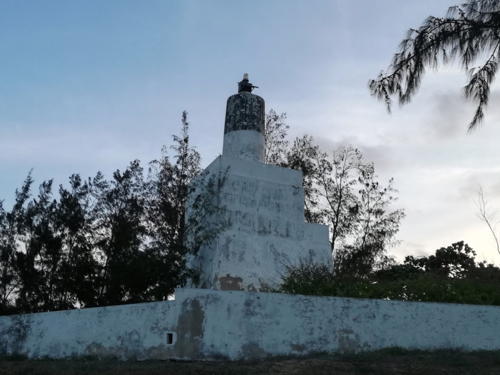
1932 (?) (station established 1915). Active; focal plane 23 m (75 ft); white flash every 5 s. 12 m (39 ft) concrete post centered on a square masonry tower. Lighthouse painted white with a black band at the top of the post. Keeper's house nearby. Antonio Brito has a 2017 closeup photo (also seen at right), Thibaut Marcilllou has a 2019 photo, another photo is available, and Google has a satellite view. Note: Lighthouse Digest has a photo of a large lighthouse; this is an error. Located on a headland marking the south side of the entrance to Pemba Bay, about 10 km (6 mi) east of Pemba. Site status unknown. ARLHS MOZ-016; Admiralty D6624; NGA 31592.
Ponta Uifundo (?)
1944. Inactive but listed with focal plane 34 m (112 ft); two white flashes every 16 s. 21 m (69 ft) square skeletal tower painted red. No photo available and the tower is not seen in Google's satellite view of the listed location. Located on a headland south of Mecúfi and about 48 km (30 mi) south of Pemba. Site status unknown. Admiralty D6622; NGA 31596.

Ponta Maunhane Light, Pemba, January 2017
Google Maps photo by Antonio Brito

Nampula Province Lighthouses

Nacala Area Lighthouses
Nacala is a seaport city of about 225,000 residents located on the Bay of Nacala, a southern branch of the broader Bay of Fernão Veloso, considered to be the best natural harbor on Africa's east coast. A railroad has been built in recent years connecting Nacala to the landlocked nation of Malawi.
* Pinda (Memba Bay, Cabo Couni)
1923. Active; focal plane 64 m (210 ft); two white flashes every 10 s. 31 m (102 ft) round masonry tower with lantern and gallery, rising through the center of a 1-story hexagonal keeper's house. Lighthouse painted with black and white horizontal bands; lantern painted red. Erik Kristensen's 2007 photo appears at right, Stig Nygaard also has a good photo, Wikimedia has photos, Ivarsen Romao has a 2022 closeup, and Google has a satellite view. The lighthouse was reported out of service in 1983, but it was restored and reactivated in 1994. Located on a headland at the southern entrance to Memba Bay, about 25 km (15 mi) east southeast of Memba; said to be an easy walk from the Wimbe beach (Praia do Wimbe). Site open, tower closed. ARLHS MOZ-011; Admiralty D6618; NGA 31604.
Nacala Approach
Date unknown. Active; focal plane 11 m (36 ft); three flashes every 9 s, white, red or green depending on direction. 6 m (20 ft) square pyramidal skeletal tower mounted on a square base. Lighthouse painted white with a black top. No photo available but Google has a satellite view. This leading light guides vessels into the Bay of Fernão Veloso. Located just behind the beach about 3 km (2 mi) northwest of the entrance to the Bay of Nacala, one of the best harbors on the East African coast. Site status unknown. Admiralty D6611.3; NGA 31616.
Ponta Sacamulo (2)
1993 (station established 1949). Active; focal plane 8 m (26 ft); green flash every 2 s. 7 m (23 ft) triangular skeletal tower mounted on a square concrete base. Lighthouse painted white. No photo available but Google has a satellite view. Located at the end of a spit on the west side of the entrance to the Bay of Nacala. Site status unknown. Admiralty D6612; NGA 31612.
* Fernão Veloso (Ponta Narenque) (2)
1993 (station established 1949). Active; focal plane 8 m (26 ft); red flash every 3 s. 5 m (17 ft) square skeletal tower enclosing a fuel tank, centered on a square 1-story white concrete equipment building. Skeletal tower painted red. Lightphotos.net has a closeup photo and Google has a satellite view. This light marks the east side of the entrance to the Bay of Nacala. Located on the point at Fernão Veloso, north of Nacala. Site open, tower closed. Admiralty D6611.6; NGA 31628.
Cabo Melamo (Cabo Columulomo)
1993 (station established 1949). Active; focal plane 10 m (33 ft) (?); white light, 2 s on, 2 s off. 12 m (39 ft) skeletal tower. No photo available but Google has a satellite view of the light station. Located on a promontory east of the entrance to the Bay of Nacala. Accessible by road from Fernão Veloso. Site status unknown. Admiralty D6611; NGA 31608.
Ponta Onlugune (Onlungune)
Date unknown. Active(?); focal plane 14 m (46 ft); three white flashes every 13.5 s. 12 m (39 ft) square concrete skeletal tower painted with black and white horizontal bands. No photo available, but Google has a satellite view. Located on a remote headland about 32 km (20 mi) south of Cabo Melamo. Site status unknown. Admiralty D6610; NGA 31640.

Pinda Light, Memba, November 2007
Flickr Creative Commons photo by Erik Kristensen

Moçambique Area Lighthouses
Moçambique is a historic island city off the coast of Nampula Province, connected to the mainland by a 3 km (2 mi) long bridge. The Portuguese established a base and fortress here in 1507 and the city served as the capital of Portguguese East Africa until 1898. It was named for the Arab sultan Ali Musa Mbiki who ruled here when Vasco da Gama's expedition arrived in 1498. The name Moçambique was later applied to the Portuguese colony that became todays' Nampula Province, finally becoming the national name when the several colonies of Portuguese East Africa were united in 1942. The city retains the original Portuguese spelling Moçambique. The island has a permanent population of about 14,000.
Ilha de Goa (Range Rear)
1876. Active; focal plane 30 m (98 ft); two white flashes every 12 s. 31 m (102 ft) square brick tower with lantern and gallery, rising from the center of a 1-story keeper's house. Lighthouse painted with red and white horizontal bands. The lantern is abandoned and the light is shown from a short mast atop the tower. Margarida Ferreira's 2010 photo, Eric Lafforgue has a 2013 closeup, Ricardo Barradas has a view from the sea, a 2012 view from the sea is available, Marco Oliveira has a street view from atop the tower and Google has a good satellite view. This is Mozambique's oldest surviving lighthouse and a national treasure. The 12 m (40 ft) top section was added in 1923, and the tower was rehabilitated in 1994. The lighthouse is a landfall light, but it also serves as the rear light of an exit range guiding departing vessels. The lighthouse stands on a small island about 5 km (3 mi) east southeast of Moçambique. Accessible only by boat; there should be a distant view from the Moçambique waterfront. Site status unknown. . ARLHS MOZ-005; Admiralty D6598.1; NGA 31661.
Ilha de Goa Range Front
Date unknown. Active; focal plane 14 m (46 ft); quick-flashing white light. 14 m (46 ft) square pyramidal skeletal tower with gallery and an enclosed base. Lighthouse painted white. Ricardo Barradas has a view from the sea showing both range lights and Google has a satellite view. This is the front light of the exit range guiding departing vessels. Located on the beach on north side of the Ilha de Goa. Site status unknown. Admiralty D6598; NGA 31660.
* Moçambique Capitania do Porto (?)
Date unknown. Active (?); listed with focal plane 15.5 m (50 ft); continuous green light. 15 m (49 ft) square cylindrical masonry tower, painted white. No photo available and the light has not been found in Google's satellite view. This light has apparently been moved; since 2015 NGA has described it as a white hut on piles. The new location is unknown. Located on the waterfront of the Ilha de Moçambique. Site open, tower status unknown. Admiralty D6604; NGA 31680.
Ilhéu de São Lourenço (Moçambique Range Front)
Date unknown. Active; focal plane about 10 m (33 ft); white flash every 3.4 s. Light atop an approx. 5 m (16 ft) square white equipment building. A photo is available and Google has an indistinct satellite view. NGA lists the focal plane as 10 ft and the tower height as 7 ft; probably 10 m and 7 m were intended. This is the approach range for Moçambique. Located adjacent to the ruins of the Fortim de São Lourenço on an islaet just off the southern tip of the Island of Moçambique. Accessible only by boat. Site open, tower closed. Admiralty D6602; NGA 31652.

Ilha de Goa Light, Moçambique, October 2022
Google Maps photo by Rejoy
Sancul (Moçambique Range Rear)
Date unknown. Active; focal plane 21 m (69 ft); white flash every 4 s. 16 m (52 ft) "tower on pyramid," according to NGA. No photo available but Google has a satellite view. This is the rear light of the approach range for Moçambique. Located at Sancul, on the mainland southwest of the Ilha de Moçambique. Site status unknown. Admiralty D6602.1; NGA 31656.

Angoche Area Lighthouses
Angoche (called António Enes under Portuguese rule) is a historic port founded by Arab traders in the 1490s. Recently Chinese investors have been developing modern port facilities. It has a population of about 90,000.

Ponta Namalungo
1937. Inactive but listed with focal plane 84 m (276 ft); four white flashes every 15 s. 19 m (62 ft) square white concrete skeletal tower. Keeper's house in ruins. No photo available, but Bing has a satellite view. This lighthouse replaced the 1926 Infusse Light. Located on a headland about 75 km (46 mi) south southwest of Moçambique. Site status unknown. ARLHS MOZ-031; Admiralty D6596; NGA 31684.
Sangage
1925. Inactive but listed with focal plane 93 m (305 ft); white flash every 5 s. 26 m (85 ft) hexagonal concrete tower with lantern and gallery, painted red with white horizontal bands. No current photo available but Silva Pais has a historic photo and Google has a good satellite view. Nate Johnson visited this site in late 2006 and found the lighthouse was not operating. Located on a headland about 35 km (22 mi) northeast of Angoche. Site status unknown. ARLHS MOZ-021; Admiralty D6592; NGA 31688.
Monte Parapato (Angoche) (2?)
Date unknown. Active; focal plane 67 m (220 ft); quick-flashing white light. Described as an 8 m (26 ft) white truncated conical tower mounted on a building, but Google's satellite view reveals a tall skeletal tower, probably a radar tower, at this location. Located atop a ridge on the south side of Angoche. Site status unknown but probably open. Admiralty D6591; NGA 31692.
* Angoche Port Office (2?)
Date unknown. Active; focal plane 11 m (36 ft) (?); two green flashes every 6 s. Listed as an 8 m (26 ft) white masonry tower atop the port office. Google's satellite view reveals a square white skeletal tower roughly 20 m (66 ft) tall that is more likely to carry the light; Shanaya Santos has a photo. More information needed! Located on the waterfront of Angoche. Site probably open, tower closed. Admiralty D6591.4; NGA 31700.
Ilha de Mafamede (2)
Date unknown (station established 1924). Reactivated(?); focal plane 24 m (78 ft); two red flashes every 10 s. 25 m (82 ft) hexagonal concrete tower with gallery, painted white. An INAHINA photo is at the top of this page, Gilberto Alvaro has a 2018 closeup photo and Google has a satellite view. The Admiralty reported this light in service in 2011 but it did not appear active in Henry Dowling's 2017 closeup photo. Alvaro's photo shows that the lighthouse was at least repainted, and possibly reactivated, in 2018. Silva Pais has a historic photo of the original lighthouse. Located on an island off the entrance to the estuary leading to Angoche, about 20 km (13 mi) southeast of the town. Accessible only by boat. Site open, tower closed. ARLHS MOZ-006; Admiralty D6590; NGA 31704.
Ponta Caldeira
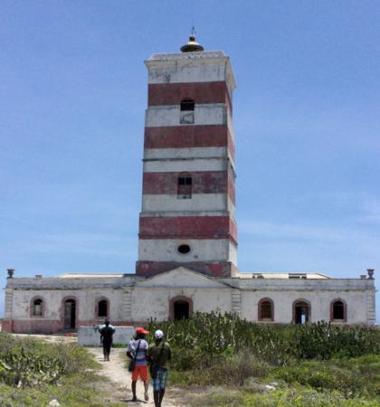
1926. Active (?); listed with focal plane 50 m (164 ft); three white flashes every 10 s. 26 m (86 ft) octagonal concrete tower with lantern and gallery, painted with red and white horizontal bands. INAHINA's photo is at right, Albertino Silva has a 2007 photo, the lighthouse appears on a 1989 postage stamp, and Google has a satellite view. For most of its life the lighthouse was painted white; the red bands and a new lantern were added when the lighthouse was rehabilitated and reactivated in 2007. However, the INAHINA page described it as inactive. Silva Pais has a historic photo. Located near Namorre, 65 km (40 mi) southwest of Angoche. Site status unknown. ARLHS MOZ-012; Admiralty D6586; NGA 31708.
Ponta Caldeira Light
Ponta Caldeira Light, Angoche, 2007
INAHINA photo

Zambezia Province Lighthouses

Pebane Area Lighthouses
Ilha Epidendron (Epidendro) (2)
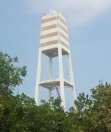
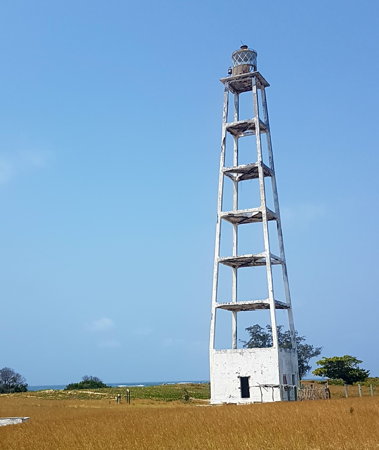
1953 (station established 1932). Active; focal plane 31 m (102 ft); two flashes every 5 s, white or red depending on direction. 24 m (79 ft) square white concrete skeletal tower rising from a square white concrete equipment building. The upper portion of the tower is surrounded by a daymark painted with red and white horizonal bands. Henry Dowling has the 2017 photo seen at right, an undated photo (second photo on the page) is available, the light is visible in an aerial photo of the island, and Google has a satellite view. The original lighthouse was an iron skeletal tower; the present one was restored in 1996. Located on an island off the coast south of Moma. Accessible only by boat. Admiralty D6582; NGA 31712.
Ilha do Fogo (2)
1954 (station established 1926). Active; focal plane 35 m (115 ft); white flash every 12 s. 34 m (111 ft) square white concrete skeletal tower with lantern. Henry Dowling's photo is also seen below right and Bing has a satellite view. Silva Pais has a historic photo of the original lighthouse, a 37 m (121 ft) octagonal skeletal tower. Located on an island off the coast southwest of Moma; the island is now the site of an adventure resort. Accessible only by boat. Admiralty D6580; NGA 31716.
Ponta Matirre (2)
1913. Inactive but planned to be restored and reactivated, according to INAHINA. Listed with focal plane 50 m (164 ft); three white flashes, in a 2+1 pattern, every 12 s. Described as a 13 m (43 ft) square skeletal tower with lantern and gallery, painted with red and white horizontal bands. The present tower may be taller. Keeper's house, formerly described in NGA as a signal station but now in ruins. No current photo available but Bing has a satellite view. Silva Pais has a historic photo of the original tower. The Admiralty reported the light in service in 2010. Located on a headland on the east side of the entrance to the bay of Pebane; accessible from the nearby beach. Site status unknown. ARLHS MOZ-030; ex-Admiralty D6576; NGA 31720.

Quelimane Area Lighthouses
Quelimane, the capital of Zambezia Province, is a historic seaport founded by Arab traders. The city has a population is about 350,000.

Macuse (Macuze) (2)
1962 (station established 1934). Inactive at least since 2017 but listed by NGA with focal plane 21 m (69 ft); white flash every 3 s. 20 m (66 ft) square concrete skeletal tower. No photo available but Google has a satellite view. This light is likely to be reactivated in the future. Located about 4 km (2.5 mi) southwest of the entrance to the Macuse River. Site status unknown. ex-Admiralty D6575; NGA 31724.
Quelimane First Range (Marca I) Rear (?)
Date unknown. Active; focal plane and light characteristic unknown. Approx. 12 m (39 ft) round white concrete tower. No photo available but the light is not seen in Google's satellite view. This is the first of five ranges leading vessels up the Rio dos Bons Sinais to Quelimane. Located on the south side of the entrance to the river. Site status unknown. Admiralty D6571.1.
Vilhena (2)
1997 (station established 1909). Active; focal plane 31 m (102 ft); two white flashes, separated by 4.5 s, every 12 s. 27 m (89 ft) square skeletal tower with lantern and gallery, painted with red and white horizontal bands. No current photo available but Bing has a satellite view. Although the historic lighthouse appears on a 1989 postage stamp the satellite view shows only the present tower. It appears to be built inside the foundation square of the original. Located at Mucupia, southeast of Quelimane, guiding vessels toward the southern entrance to the Quelimane estuary. Site status unknown. ARLHS MOZ-032; Admiralty D6570; NGA 31740.
Ponta Inhamiara (?)
1913. Inactive but listed with focal plane 22 m (72 ft); white flash every 5 s. 10 m (33 ft) square skeletal tower. No photo available but no tower is seen in Google's satellite view. The light was relocated several times due to changes in the configuration of the coast. Located on a hill on the north side of the delta of the Zambezi River. Site status unknown. Admiralty D6566; NGA 31744.
#Ilha Timbué (Ilha Timbwé, Bôcas de Zambeze) (2) (?)
1961 (station established 1924). Destroyed but still listed with focal plane 41 m (135 ft); white flash every 8 s. This was a 39 m (128 ft) square skeletal tower, painted with red and white horizontal bands. No photo available. Bing formerly had a satellite view of the ruins of the station, but they have now disappeared into the rising sea. Ilha Timbué is an island in the delta of the Zambezi River. The location of the station was on the beach and the buildings were probably destroyed by the tropical cyclones that occur fairly often along this coast. The original lighthouse was a 40 m (131 ft) hexagonal concrete tower with lantern and gallery. Site status unknown. ARLHS MOZ-025; Admiralty D6564; NGA 31752.


Ilha Epidendron Light, Zambezia, September 2017
Google Maps photo by Henry Dowling


Ilha do Fogo Light, Zambezia, September 2017
Google Maps photo by Henry Dowling


Information available on lost lighthouses:

Notable faux lighthouses:

Adjoining pages: North: Tanzania | East: Comoros, Madagascar | South: Southern Mozambique

Return to the Lighthouse Directory index | Ratings key

Posted June 21, 2005. Checked and revised January 23, 2024. Lighthouses: 38. Site copyright 2024 Russ Rowlett and the University of North Carolina at Chapel Hill.