Lighthouses of Germany: Flensburg to Lübeck

The Federal Republic of Germany (Bundesrepublik Deutschland in German) occupies a central location in northern Europe with two coastlines, one facing northwest on the North Sea (Nordsee) and the other facing northeast on the Baltic Sea (Ostsee, East Sea in German). The country's history is long and complex. The large number of historically independent German regions came together in 1871 to form the German Empire. The Empire became a republic after World War I (1914-18). After World War II (1939-45) Germany was divided into two countries, the German Federal Republic in the west, usually called West Germany, and the Communist-led German Democratic Republic in the east, usually called East Germany. After the Communist government collapsed the Federal Republic reunified the nation in October 1990.

Germany is a federation of 16 member states called Bundesländer, and the states are divided into districts (Kreise). This page lists lighthouses of the Baltic coast from Flensburg at the Danish border southeastward to Lübeck. This area comprises all of the eastern coast of the state of Schleswig-Holstein. Lighthouses of the west coast of the state are described on the North Frisia page.

The 19th-century history of Schleswig-Holstein is also complex. From 1815 to 1864 the Duchy of Schleswig (including the coast north of Kiel) was under Danish control, and the Duchy of Holstein (Kiel and southeastward) shared its sovereign with Denmark but was also a member of the German Confederation. The two duchies were combined as a single province of Prussia in 1866 and thus entered the German Empire when it was formed in 1871. As a result of this history several of the light stations in the region were established by Denmark, and one Danish lighthouse survives, at Marienleuchte on the island of Fehmarn.

Interest in lighthouses is strong in Germany and most of the towers are in good condition. A federal law provides blanket protection to historic lighthouses. There is concern, however, that many of the lights may be deactivated in the coming years as navigators depend less and less on them.

In German, a lighthouse is a Leuchtturm ("light tower"), plural Leuchttürme. The front light of a range is the Unterfeuer and the rear light is the Oberfeuer. Modern range lighthouses are crowned by a topmark: a large, distinctive structure that serves to mark the range clearly in the daytime. In German Insel is an island, Riff is a reef, Kap is a cape, Bucht is a bay, and Hafen is a harbor.

Lighthouses in Germany are operated by the regional maritime authority, called the WSA (Wasserstraßen- und Schifffahrtsamt). Recently the two WSA's for the Baltic coast, WSA Lübeck and WSA Stralsund, have been merged to form the WSA Ostsee. Two lighthouses at the northern entrance to the Kiel Canal (Nord-Ostsee Kanal) are operated by WSA Nord-Ostsee Kanal, which operates the canal and other northern inland waterways. The WSA's are linked to and regulated by a federal agency, the Wasserstraßen-und Schifffahrtsverwaltung des Bundes (WSV).

ARLHS numbers are from the ARLHS World List of Lights. DE numbers are the German light list (Leuchtfeuerverzeichnis) numbers as noted on Erich Hartmann's website. Admiralty numbers are from volume C of the Admiralty List of Lights & Fog Signals. U.S. NGA List numbers are from NGA Publication 116.

General Sources
Leuchttürme und Leuchtfeuer an der Ostsee
Photos and information posted by Erich Hartmann, a contributor to the Online List of Lights.
Online List of Lights - Deutschland Ostsee
Photos by various photographers posted by Alexander Trabas. Some of the photos are by Hartmann, Eckhard Meyer, Rainer Arndt, Klaus Potschien, or Capt. Peter Mosselberger ("Capt. Peter").
Leuchtturm-Atlas
A large site with excellent photos and information on nearly all German lighthouses, maintained by Frank and Birgit Toussaint.
Leuchttürme.net - Deutschland
Outstanding photos by Malte Werning.
Leuchtturmseiten von Anke und Jens - Germany Baltic Sea
This site has photos and information on many of the lights.
Germany Lighthouses
Photos posted to Flickr.com by Larry Myhre
Deutsche Leuchttürme an der Ostsee
Photos by Bernd Claußen.
Lighthouses in Schleswig-Holstein
Photos by various photographers available from Wikimedia.
World of Lighthouses - Germany
Photos by various photographers available from Lightphotos.net.
Germany Lighthouses
Aerial photos posted by Marinas.com.
Deutsche Leuchttürme und Seezeichen
Photos posted by Klause Huelse, who also has a page of historic postcard views.
Interessengemeinschaft Seezeichen e.V.
Germany's national lighthouse preservation organization.
GPSNauticalCharts
Navigational chart information for Germany.
Navionics Charts
Navigational chart for Germany.


 Dahmeshöved Light, Dahme, summer 2004
Wikimedia Creative Common photo by Malte Tychsen
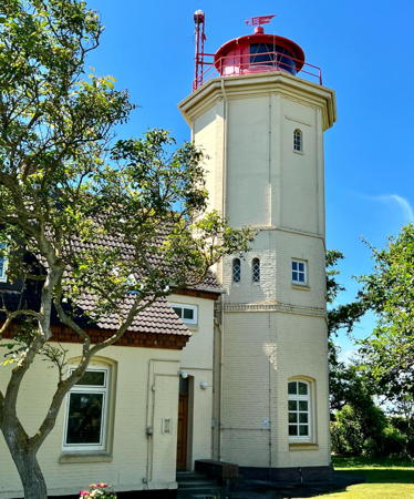

Westermarkelsdorf Light, Fehmarn, November 2022
Instagram photo by seammonkey
Schleswig - Flensburg District Lighthouses

Flensburger Förde (Flensburg Fjord) Lighthouses
The Flensburger Förde (Flensborg Fjord in Danish or Flensburg Firth in English) forms part of the boundary between Germany and Denmark. Lighthouses on the Danish side are listed on the Denmark: Southeast Jylland page.
* Holnis (2)
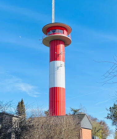
1967 (station established 1896). Active; focal plane 32 m (105 ft); white, red, or green light, depending on direction, 3 s on, 3 s off. 26 m (85 ft) round cylindrical steel and concrete tower with a large round lantern and gallery. Tower covered with hard fiberboard panels forming red and white horizontal bands; lantern and upper galleries painted red. A 2024 photo is at right, Werning has a good page for the lighthouse, Trabas has Potschien's closeup photo, Udo Schweda has a 2017 closeup, Andreas Köhler has a 2015 photo,Marinas.com has aerial photos, and Google has a satellite view. This modern lighthouse stands on the west side of the Schausende, a low peninsula projecting northward into the Flensburger Förde (Flensborg Fjord). The lighthouse displays three directional lights: one for westbound ships approaching from the Baltic, one for westbound ships that have rounded the end of the peninsula, and one for eastbound ships departing Flensburg. A major project restored the lighthouse in 2019. The original lighthouse had a focal plane height of 20 m (65 ft). The old lighthouse stood until it was demolished in 1980. Located southwest of Holnis and about 30 km (19 mi) northeast of Flensburg. Accessible by road, but parking is limited. Site open, tower closed. Operator: WSA Ostsee. . ARLHS FED-111; DE 200600; Admiralty C1134; NGA 2928.
* Neukirchen (2)
1969 (station established 1927). Inactive since 1996. 2-story brick building with a semicircular control room projecting from the upper story. Hartmann has a page for the lighthouse, Werning has a photo and Google has a satellite view. Apparently this was a ship traffic control tower for the approaches to Flensburg; it also carried a directional light in a lantern that has been removed. Sold into private ownership, the building is now a residence. The original Neukirchen lighthouse was relocated to Mönkeberg, near Kiel (see below). Located on on the south shore of the Flensburger Förde (Flensborg Fjord) just west of the village of Neukirchen. Site and tower closed. Owner/site manager: private. ARLHS FED-163.
* Strukkamphuk Unterfeuer (2) (lantern, relocated to Wackerballig)
1896. Inactive since 1935. The original lighthouse, on the island of Fehmarn, was replaced by a new concrete tower (see below). The lantern's subsequent history is unknown but presently it stands at the elbow of the long breakwater mole of the yacht harbor of Wackerballig, at the southwestern base of the Gelting Peninsula. U. Walli has a photo and the lantern can be seen in Google's satellite view of the marina. Marinas.com has aerial photos of the marina but the tiny lantern is hard to see (click on the first photo to zoom). Used as a shelter, the lantern does not appear to be in very good condition. Site and lantern open. Owner/site manager: Jachthafen Wackerballig.

Holnis Light, Holnis, March 2024
Google Maps photo by Peter Pan

Angeln Lighthouses
Angeln (Anglia) is a semicircular peninsula between the deep indentations of the Eckernförde and the Flensburger Förde. People from this area, known as Angles, settled in Britain during the Dark Ages and England is named for them.
Kalkgrund
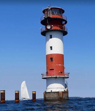
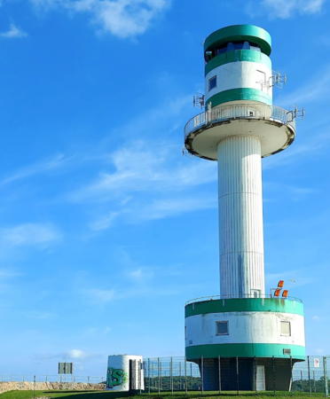
1963 (lightship station established 1876). Active; focal plane 22 m (72 ft); white, red, or green light, depending on direction, 4 s on, 4 s off. 24 m (79 ft) round cylindrical tower with lantern and three galleries, one near the bottom and two at the top of the tower. Lighthouse painted with red and white horizontal bands and floodlit at night. Fog horn (Morse code "FS": two short blasts, a long blast, a short blast, a pause, and three short blasts, every 30 s). A 2021 photo is at right, Trabas has a photo by Hans-Albert Liebetrau, a 2019 photo is available, and Google has a satellite view. This lighthouse replaced the lightship Flensburg (Kalkgrund). Wikimedia has Holger Ellgaard's 1961 photo of the lightship (the ship has been converted to the schooner Noorderlicht, based at Muiden, Netherlands). Originally an artificial island was planned; instead, the lighthouse stands on 30 steel pilings 30 m (100 ft) long. Located in the middle of the entrance to the Flensburger Förde (Flensborg Fjord) about 8 km (5 mi) north of Birk-Nack, the northern tip of the Gelting Peninsula. Accessible only by boat; Udo Schweda's photo shows that the lighthouse is distantly visible from Birk-Nack. Site and tower closed. Operator: WSA Ostsee. . ARLHS FED-123; DE 200300; Admiralty C1113; NGA 2900.
*** Falshöft
1910. Inactive since 2002. 24 m (79 ft) round cast iron tower with lantern and double gallery, painted with red and white horizontal bands. Leuchtturm-Atlas has a good page for the lighthouse, Werning's page for the lighthouse has a fine photo, Hartmann also has a page with a great photo, Rainer Jost has a photo, Michael Arnhold has a 2021 photo, Huelse has a historic postcard view, Richard Hovorka has a street view, and Google has a satellite view. This light guided coastwise traffic bound to and from Flensburg. WSA Lübeck decided to deactivate the light in 2002, despite public protests, after the radio link with its central office failed and it was judged too expensive to restore it. In 2003 the tower was sold to the nearby town of Pommerby, which has opened a registrar's office in the tower for the convenience of citizens who want to get married at the lighthouse (something very popular in Germany). The tower continues to serve as a daybeacon. Located about 8 km (5 mi) southeast of Birk-Nack and 2 km (1.2 mi) east of Pommerby. Accessible by road, but parking is limited. Site open, tower open Tuesday, Wednesday, Friday, plus Saturday and Sunday of the first four weekends of the month, April through October. Owner: Municipality of Pommerby. Site manager: Förderverein Leuchtturm Falshöft . ARLHS FED-005; ex-Admiralty C1108.

Kalkgrund Light, Flensburger Förde, July 2021
Google Maps photo by E K
* Schleimünde Mole (2)
1871 (station established 1841). Active; focal plane 14 m (46 ft); three long (2 s) flashes every 20 s, white or red depending on direction. Fog horn (Morse code "SN": three short blasts, a pause, 1 long blast, and one short blast, every 30 s). 14 m (46 ft) round tile-covered brick tower with lantern and gallery. In 2015 the lighthouse was restored and painted with green and white horizontal bands; previously it was covered with fiberboard panels forming black and white horizontal bands. Trabas has a closeup photo, Frank Schreiber has a 2018 closeup, a 2021 photo is available, Marinas.com has aerial photos, Heinrich Gerzen has a 2021 street view, and Google has a satellite view. Danish authorities built moles to stabilize the entrance to the Schlei estuary in 1842 and German authorities added this lighthouse in 1871, shortly after Schleswig reverted to German control. WSA Lübeck began a thorough restoration of the tower, lantern room, and lens in the summer of 2014 and the work was completed in the spring of 2015. Located at the end of the north mole at the entrance to the Schlei. Accessible only by boat; transportation to the mole and adjoining barrier island is available from Maasholm or Kappeln, but only brief visits to the lighthouse are possible. Site open, tower closed. Operator: WSA Ostsee. . ARLHS FED-217; DE 201700; Admiralty C1186; NGA 3000.

Rendsburg - Eckernförde District Lighthouses

Eckernförde Lighthouses
* Eckernförde Hafen (1) (relocated)
1907. Inactive since 1981. 12 m (40 ft) round cast iron tower with lantern and gallery, painted with horizontal navy blue and yellow bands (the colors of the city's flag). The Anke/Jens site has a good photo, Matthias Kohrt and Helena Clemens-Kohrt have a closeup, Philip Kersten has a street view, and Google has a satellite view. Huelse has a historic postcard view of the light when it was active. After deactivation this tower was sold or donated to the city of Eckernförde. Repainted in the city's colors, it is located in a city market area on the waterfront a little southwest of the original site. Site open, tower closed. Owner/site manager: Stadt Eckernförde. ARLHS FED-074.
* Eckernförde Hafen (2)
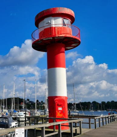
1981 (station established 1907). Active; focal plane 11 m (36 ft); white, red, or green light, depending on direction, 3 s on, 1 s off. 10 m (33 ft) round cylindrical fiberglass tower with lantern and gallery, painted red with one white horizontal band. Andreas Knopf has the 2021 photo sen at right, Harald Hinnerichs has a similar photo, Hartmann has a page for the lighthouse, a 2008 closeup photo is available, Werning's page has a great photo, Trabas has a closeup, and Google has a street view and a satellite view. Located just inside the breakwater of the small boat harbor of Eckernförde. Site open, tower closed. Operator: WSA Ostsee. . ARLHS FED-076; DE 202300; Admiralty C1210; NGA 3072.
* Eckernförde (2)
1986 (station established 1907). Active; focal plane 36 m (118 ft); directional light displayed to the east northeast: white, red, or green light, depending on direction, 3 s on, 1 s off; two white flashes every 9 s displayed to the east; continuous red or white light displayed to the northeast. 27 m (89 ft) square cylindrical concrete and steel tower carrying a square lantern structure with two large square galleries. The tower is unpainted gray concrete; lantern and platforms colored red. Werning's page has a good photo, Bernd Claußen has a 2007 photo, Trabas also has a good photo by Stephan Hix, Udo Schweda has a photo, a distant street view is available, and Google has a satellite view. The lighthouse strongly resembles an air traffic control tower. Its directional light guides ships down the 25 km (15 mi) length of the Eckernförde estuary from the Kieler Bucht (Kiel Bay). Located off the Berlinerstraße in Eckernförde, about 4 km (2.5 mi) south of the harbor entrance light. Site open, tower closed. Operator: WSA Ostsee. ARLHS FED-073; DE 202200; Admiralty C1206; NGA 3068.
* Eckernförde (1)
1907. Inactive since 1986. 17 m (56 ft) square 4-story keeper's house with a pyramidal roof and a gallery around three sides of the top floor. Evidently the light was shown through windows of the top floor. The Anke/Jens site has a good photo, Werning's page has a good closeup, and Google has a satellite view. Like the present light, the purpose of this lighthouse was to shine a directional light up the length of the Eckernförder Bucht. Located about 600 m (1/3 mi) southeast of the modern light. Site and tower closed (private property). Owner/site manager: private. ARLHS FED-075.

1981 Eckernförde Hafen Light, Eckernförde, September 2021
Google Maps photo by Andreas Knopf

Strande Area Lighthouses
Kiel
1967. Active; focal plane 29 m (96 ft); white, red, or green light, depending on direction, 3 s on, 3 s off. 33.5 m (110 ft) round cylindrical aluminum-clad tower rising from a circular 2-story building and supporting a large circular control room and lantern structure. Lighthouse colored red above and below; the cylindrical center section is white. The lighthouse is built on an L-shaped concrete pier. Fog horn (Morse code "KI": short blast, long blast, short blast, pause, two more shore blasts, every 30 s). Trabas has a photo by Pauline and Wim de Kleine, Frank Long has a 2022 photo, Werning has a good page with a distant photo, Leuchtturm-Atlas also has a good photo, and Bing has a satellite view. This lighthouse replaced the lightship Kiel. It guides ships into Kiel and the Nord-Ostsee Kanal; some 90,000 ships a year are said to pass the tower. Located off the entrance to Kieler Förde, about 8 km (5 mi) northeast of the Bülk lighthouse. Accessible only by boat. Site and tower closed. Operator: WSA Ostsee. . ARLHS FED-011; DE 202400; Admiralty C1215; NGA 3080.
**** Bülk (3)
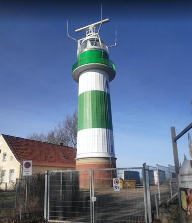
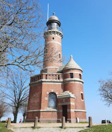
1865 (station established 1807). Active; focal plane 29 m (95 ft); flash every 3 s, white, red, or green depending on direction. 25 m (82 ft) round brick tower with lantern and double gallery adjacent to 1-1/2 story brick keeper's house. Since 1970 the tower has been covered with hard fiberboard panels originally colored so that the tower was white with a broad black horizontal band. In 2020-21 the exterior of the lighthouse was restored and it now has green and white horizontal bands; the lantern is white. Michael Witt's 2021 photo is at right, Hartmann has a page for the lighthouse, Trabas has a great photo, Brigitte Koehrsen also has a good photo, Hans Jürgen Groß has a 2021 photo, and Google has a 2014 street view and a satellite view. The lighthouse is the third built by Danish authorities at this station, but it was completed and placed in service after Schleswig-Holstein was ceded to Germany. Huelse has a historic postcard view showing the original (smaller) lantern and the older daymark with a red horizontal band. The lighthouse was restored in 1970 (when the fiberboard panels were added), changing its appearance significantly; since then it has been open to the public under the care of a lessee. The original lantern came into private hands; Ronald Wöhrn found it in use as a storage shed at a marina in Wentorf. Located at the western entrance to the Kieler Förde, about 5 km (3 mi) northeast of Strande. Site open, tower open daily except Mondays. Operator: WSA Ostsee. Site manager: Leuchttürm Bülk. . ARLHS FED-003; DE 202600; Admiralty C1216; NGA 3084.

Bülk Light, Strande, February 2021
Google Maps photo by Michael Witt

Kiel City Lighthouses

Kiel is the capital of Schleswig-Holstein and a major port, naval base, and sailing center. The population of the city proper is about 250,000 and the metropolitan population is nerly 650,000.

Kieler Förde (Kiel Fjord) Lighthouses
Kiel's harbor, the Kieler Förde (Kiel Firth or Kiel Fjord) is an inlet of the Baltic Sea approximately 17 km (11 mi) long and 1-3 km (0.6-1.8 mi) wide. The city's harbor area is on the west side of the fjord.

* Friedrichsort (3)
1866 (station established 1807). Inactive since 1971. Cast iron lantern, gallery, and watch room from the former Friedrichsort lighthouse, now mounted on a steel mast. Structure painted gray; lantern roof is black. Werning has a good photo, Michael Knaust has a 2020 photo, and Google has a 2023 street view and a satellite view. This is the lantern and watch room installed in 1889 on the 1866 lighthouse, an 11 m (36 ft) brick tower. Friedrichsort is on a promentory projecting into the west side of the Kieler Förde about 20 km (13 mi) north of Kiel, narrowing the estuary to a width of only 1 km (0.6 mi). Winter storms force waves and ice into the estuary, causing severe shoreline erosion on the point. The first two lighthouse were destroyed in this way, and the 1866 lighthouse was demolished in 1971 when it was about to collapse into the water. The lantern and watch room were saved and displayed in 1975 at the inner harbor of Kiel; in 2003 they were moved to their present location on Friedrichsorter Straße at the Heinrich-Rixen-Platz about 1 km (0.6 mi) north of the Friedrichsort waterfront. Site open, tower closed. Owner/site manager: unknown. ARLHS FED-126.
* Friedrichsort (4)
1971 (station established 1807). Active; focal plane 32 m (105 ft); white, red, or green light, depending on direction, 2 s on, 2 s off; also a continuous white light displayed at a focal plane of 6 m (18 ft). The tower is also floodlit at night. 32 m (105 ft) round cylindrical reinforced concrete tower with a large drum-shaped lantern structure and gallery at the top and a circular equipment room near the bottom. Lighthouse painted white with four narrow green horizontal bands, two on the lantern and two on the equipment room. Elfi Bagnep's 2022 photo is at right, Thore Siebrands has a good photo, Trabas has a photo, Leuchtturm-Atlas also has a photo, Rüdiger Schmedemann has a 2021 photo, Björn Staac has a street view, Marinas.com has aerial photos, and Google has a good satellite view. The former WSA Lübeck escaped continuing beach erosion at Freidrichsort by moving the lighthouse offshore. Its main purpose is to shine directional lights both up and down the Kieler Förde, defining the safe channel for both inbound and outbound shipping. Huelse has a postcard view of the 1866 lighthouse (see the previous entry). Located on an artificial island north of the tip of the Friedrichsort peninsula; the island is joined to the mainland by a sandbar, making the lighthouse accessible at low tide. Site and tower closed. Operator: WSA Ostsee. . DE 202640; ARLHS FED-125; Admiralty C1230; NGA 3112.

Friedrichsort Light, Kiel, October 2022
Google Maps photo by Elfi Bagnep
** Holtenau Nord
1895. Active; focal plane 22 m (72 ft); white or green light, depending on direction, occulting three times, separated by 2 s, every 12 s. 20 m (66 ft) round cylindrical brick tower with lantern and gallery rising from the front of a 2-story brick Imperial-style building. Lighthouse unpainted, lantern is black. A 2023 photo is at right, Harald Hinnerichs has an excellent 2008 photo, Hartmann has a good page for the lighthouse, Werning also has a page for the lighthouse, Trabas has a closeup photo by Ulrich Bode, another excellent photo is available, Hans Jürgen Groß has a 2021 photo, Huelse has a historic postcard view, and Google has a street view and a good satellite view. This lighthouse stands at the northeastern entrance of the Nord-Ostsee Kanal (Kiel Canal). Since 1895 this 98.7 km (61.3 mi) canal has provided a shortcut between the North Sea and the Baltic Sea via Kiel. The building includes a memorial hall, the Drei-Kaiser-Gedächtnishalle, in remembrance of the emperors Wilhelm I, who inaugurated construction of the canal in 1887; Friedrich III, who turned the first shovel of dirt here in 1888, and Wilhelm II, who laid the cornerstone of the lighthouse in 1895. It also houses a registrar's office where weddings are performed. Located at the end of the Thiessenkai, the quay on the north side of the canal in Holtenau, about 12 km (7.5 mi) north of Kiel. Site open, building open daily; it is not known if the tower can be climbed. Operator: WSA Nord-Ostsee Kanal. . ARLHS FED-112; DE 203440; Admiralty C1246; NGA 3116.
Holtenau Süd (2)
2014 (station established 1895). Active; focal plane 23 m (75 ft); white or red light, depending on direction, occulting two times, separated by 2 s, every 9 s. 20 m (66 ft) round cylindrical tower carrying a large octagonal lantern structure and a radar antenna. Tower painted with red and white horizontal bands. Trabas has a good photo of the new lighthouse by Hartmann, Thomas Mekota has a 2015 photo, Bernd Claußen has photos of its construction in late 2013, and Google has a satellite view. Werning's page for the lighthouse depicts the original lighthouse, a slender octagonal skeletal tower with round lantern and gallery. Hartmann's page has photos of both towers. The lighthouse marks the south side of the entrance to the Nord-Ostsee Kanal; it had to be relocated in 1914 when new, larger locks were built. The original lantern, replaced in 1998, is now on display at the Schifffahrts- und Meeresmuseum Peter Tamm in Hamburg. Located at the end of the south mole at the canal entrance in Holtenau. Site and tower closed. Operator: WSA Nord-Ostsee Kanal. ARLHS FED-113; DE 203450; Admiralty C1248; NGA 3120.
* [Lightship Reserve Sonderburg (Kiel III) (light tower)]
1906. Decommissioned 1986. This 53.3 m (175 ft) steel lightship was sold to a sail training institute in Bremerhaven and converted to a 3-masted sailing ship. The light tower was saved and is on display outside the maritime museum in Kiel. A 2016 photo is available, Manfred Morwinski has a closeup, Harald Guenther has a street view and Google has a satellite view. Located on the Kiel waterfront adjacent to the museum. Site open, tower closed. Owner/site manager: Kieler Schifffahrtsmuseum.

Holtenau Nord Light, Holtenau, April 2023
Google Maps photo by Annett

Plön District Lighthouses

Kieler Förde (Kiel Fjord) Lighthouses
[Mönkeberg Deviationsbake]
1886. Inactive since 1988. 72.5 m (238 ft) square skeletal tower with two galleries; the upper gallery displays a triangular slatted daymark and the lower gallery displays a square slatted daymark. A page for the beacon has a photo and describes its history. Google has a satellite view. This beacon was used in connection with a series of small beacons in the Kieler Förde; by sighting from one of these small beacons to the main beacon ships could calibrate their compasses. It's not clear if the beacon ever carried a light. Located on a hilltop off the Dorfstraße in western Mönkeberg. Site status unknown.
* Neukirchen (1) (relocated to Mönkeberg)
1929. Inactive since 1969. Approx. 5 m (17 ft) round cast iron tower with lantern and gallery. Lighthouse painted white, lantern roof red. Werning has a good photo, Ayad Deab has a 2018 photo, Claußen has photos, and Google has a street view and a satellite view. This little lighthouse originally stood at Neukirchen near Flensburg (see above). It serves now as the harbormaster's office of the yacht harbor of Mönkeberg, on the east side of the Kieler Bucht about 5 km (3 mi) northeast of Kiel. Located on the south pier of the harbor. Site open, tower status unknown. Owner/site manager: Wassersport Vereinigung Mönkeberg. ARLHS FED-162.
* Danish Lightship XV Læsø Rende
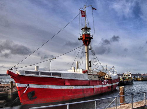
1888. Decommissioned 1971. 30 m (98 ft) wood lightship with lantern mounted on a tall mast. Hull painted red with a narrow white horizontal band; mast painted white, lantern red. A 2022 photo is at right, Graf Kinsky also has a 2022 photo, a 2021 photo is available, and Google has a street view and a satellite view. The ship served many stations; although it is often called Læsø Rende it served that station only for short periods. In 1974 it was sold to the city of Hadersleben with the idea that it would be maintained by youth organizations. This did not work out well and in 1986 it was sold to the Heikendorfer Yacht Club. Since then it has served as the organization's clubhouse. Moored at the club at Heikendorf, on the east side of Kiel Fjord. Site open, ship open to club members and guests. Owner/site manager: Heikendorfer Yacht Club. .

Lightship XV Læsø Rende, Heikendorf, January 2022
Instagram photo by Annett

Kieler Bucht Naval Warning Lights
Kiel is the traditional home port of the German Navy (Deutschemarine) and the navy's premier training area is the Kieler Bucht (Kiel Bay) between Kiel and Fehmarn. The six lights in this group, maintained by the Navy and located on the shore of Kieler Bucht, are not aids to navigation in the usual sense; they serve to delimit the offshore training areas and warn civilian ships away from training in progress.
* Heidkate
1986. Active; focal plane about 30 m (98 ft); flash every 5 s, yellow or red depending on direction. Approx. 27.5 m (90 ft) round cylindrical tower with large round lantern and gallery. Tower painted white, lantern and gallery red. Hartmann has a page for the lighthouse, Axel Hansen has a 2021 photo, Werning also has a photo, Trabas has a photo by Ulrich Bode, Thorsten Schulz has a street view, and Google has a satellite view. Located just behind the dike at the eastern entrance to the Kieler Förde at Heidkate. Site and tower closed (restricted military facility) but the tower can be viewed from nearby. Operator: Bundeswehr Marine. . ARLHS FED-100; DE 204560; Admiralty C1276.2.
* Hubertsberg
1986. Active; focal plane about 25 m (82 ft); flash every 5 s, yellow or red depending on direction. Approx. 9 m (30 ft) round cylindrical tower with large round lantern and gallery. Tower painted white, lantern and gallery red. Hartmann has a page for the lighthouse, Werning has a good closeup, Trabas has a photo by Ulrich Bode, and Google has a satellite view. Located on a bluff above the Kieler Bucht near Hubertsberg, about 20 km (13 mi) east of Schönberg. Site and tower closed (restricted military facility) but the tower can be viewed from nearby. Operator: Bundeswehr Marine. ARLHS FED-299; DE 204580; Admiralty C1276.1.
* Neuland
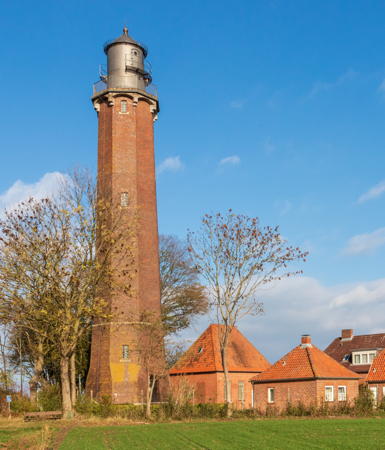
1918. Inactive as a general aid to navigation since 1996 but still active as a warning tower; focal plane 40 m (131 ft); flash every 5 s, yellow or red depending on direction. 40 m (131 ft) octagonal brick tower with lantern and double gallery. Several keeper's houses in use by the Navy. Formerly the lighthouse had red and white horizontal bands, but the paint was removed in 1986. Today the tower is a handsome red-brown brick, the lantern and gallery metallic gray. A photo by Matthias Süßen is at right, Wikimedia has photos, Trabas has a photo by Ulrich Bode, Isabell Klosek has a 2021 photo, Wolfgang Gottschalk has a photo and a closeup of the lantern, Werning has a fine page for the lighthouse, Leuchtturm-Atlas also has a fine photo, Huelse has a historic postcard view, and Google has a satellite view. This historic tower was completed in 1916 but could not be placed in service until the end of World War I. It formerly guided ships into the Hohwachter Bucht to the small port of Hohwachter. It was deactivated in 1996 and transferred to the Navy as a warning tower. Located near the shore about 5 km (3 mi) east of Behrendsdorf. Site and tower generally closed (restricted military facility) but the tower can be viewed from nearby and the Navy opens the lighthouse to visitors several times each summer. Accessible by road but parking is limited. Operator: Bundeswehr Marine. ARLHS FED-164; DE 204600; Admiralty C1276; NGA 3136.

Neuland Light, Behrensdorf, October 2018
Wikimedia Creative Commons photo by Matthias Süßen

Ostholstein (East Holstein) District Lighthouses

Kieler Bucht Naval Warning Lights
* Wessek
1980s. Active; focal plane about 15 m (50 ft); flash every 5 s, yellow or red depending on direction. 8 m (27 ft) lantern and gallery on a very short round cylindrical tower rising from a 1-story brick observation and command center. The lantern and gallery, painted gold previously, are now painted red as seen in Werning's photo and Hartmann's photo posted by Trabas. Hartmann also has a page for the lighthouse, Markus Prinzhorn has a distant street view down the beach, and Google has a satellite view. Located just above the beach on the east side of Hohwachter Bucht northeast of Weißenhäuser Strand. Site and tower closed (restricted military facility) but the tower can be viewed from nearby. Operator: Bundeswehr Marine. ARLHS FED-317; DE 204680; Admiralty C1328.1.
* Blankeck
1980s. Active; focal plane about 25 m (82 ft); flash every 5 s, yellow or red depending on direction. 12 m (40 ft) round cylindrical tower with large round lantern and gallery. Tower painted white, lantern and gallery red, or perhaps orange as seen in Werning's photo. Hartmann has a page for the lighthouse, Trabas has Hartmann's photo, another photo is available, and Google has a satellite view. Located just off the beach near Johannistal, about 13 km (8 mi) west of Heiligenhafen. Site and tower closed (restricted military facility) but the tower can be viewed from nearby. Operator: Bundeswehr Marine. ARLHS FED-284;DE 204780; Admiralty C1328.2.
* Heiligenhafen Warnfeuer
1980s. Active; focal plane about 27 m (89 ft); flash every 5 s, yellow or red depending on direction. 20 m (66 ft) round cylindrical tower with large round lantern and gallery. Tower painted white, lantern and gallery red. Hartmann has a page for the lighthouse, Werning has a distant photo, Trabas has Klaus Potschien's photo, Milan Ramske has a 2018 photo, and Google has a street view and a satellite view. Located just off the beach about 5 km (3 mi) west of Heiligenhafen. Site and tower closed (restricted military facility) but the tower can be viewed from nearby. Operator: Bundeswehr Marine. ARLHS FED-106; DE 204790; Admiralty C1328.3.

Heiligenhafen and Fehmarn Lighthouses
Fehmarn is an island in the Baltic north of Heiligenhafen, separated from the mainland by the narrow Fehmarnsund on the south and from the Danish island of Lolland by the Fehmarn Belt on the north. Germany completed a bridge over the Fehmarnsund in 1963. Denmark and Germany plan to build a tunnel under the Belt, which is 18 km (11 mi) wide. Construction began in 2021 but the link cannot be completed before 2029. When completed it will put Fehmarn on a main auto (E47) and rail route between western Europe and Scandinavia.

*
Heiligenhafen (3)
1938 (station established 1885). Active; focal plane 16 m (52 ft); white, red, or green light, depending on direction, occulting twice every 9 s. 13 m (42 ft) square cylindrical brick tower with lantern and gallery, attached to 1-story brick keeper's house. Tower unpainted; lantern and gallery painted white. A photo is at right, Trabas has closeup photo, Werning also has a good photo, Claußen has a page with several photos, and Google has a street view and a satellite view. Heiligenhafen is on the mainland shore of the Fehmarnsund, with its harbor protected by the long Graswarder sand spit. This lighthouse guides ships as they round the end of the spit to enter the harbor. The original light was mounted on a fish packing house; after that building burned, a 10 m (33 ft) round stone tower was built in 1907. Huelse has a rare postcard view showing both the 1907 and present lighthouses. Located just off the coastal road about 5 km (3 mi) east of the center of Heiligenhafen. Site open, tower closed. Operator: WSA Ostsee. . ARLHS FED-105; DE 205200; Admiralty C1328; NGA 3156.

Heiligenhafen Light, Heiligenhafen, August 2015
Wikimedia Creative Commons photo by Ein Dahmer
* Strukkamphuk (Unterfeuer) (3)
1935 (station established 1872). Active; focal plane 7 m (23 ft); white or red light, depending on direction, 1.5 s on, 1.5 s off, intensified on the range line. 5 m (17 ft) round cylindrical concrete tower with lantern, painted white. Werning has an excellent page for this little lighthouse, Leuchtturm-Atlas also has a closeup photo, Trabas has a closeup by Klaus Potschien, Marinas.com has aerial photos, and Google has a street view and a satellite view. In addition to serving general navigation, this little lighthouse has served since 1977 as the front light of a range that guides westbound ships entering the Fehmarnsund. The rear light is on the Flügge lighthouse (next entry). The first light here, mounted on a wood post, was replaced in 1896 by a round cast iron tower. The lantern from the 1896 lighthouse is now at the yacht harbor in Wackerballig, near Flensburg (see above). Located on a point of land on the south side of Fehmarn about 2.5 km (1.5 mi) west of the Fehmarnsund bridge (E47); Site open, tower closed. Operator: WSA Ostsee. . ARLHS FED-234; DE 204900; Admiralty C1288; NGA 3216.
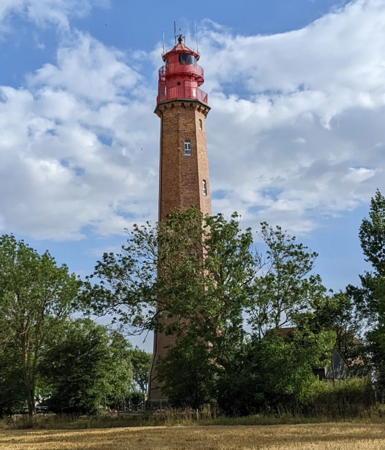
**** Flügge (Oberfeuer) (2)
1916 (station established 1872). Active; focal plane 38 m (125 ft); white light, occulting four times every 20 s (2.5 s on, 1.5 s off but with every fifth occultation omitted); also a continuous white light is shown along the Strukkamphuk range line at a focal plane of 37 m (122 ft). 37 m (122 ft) octagonal brick tower with lantern and double gallery; Fresnel lens in use. The tower is unpainted red-brown brick; lantern, watch room, and galleries painted red. This is an unusually complete light station, with several keeper's houses and other buildings preserved. A 2023 photo is at right, Wikimedia has photos, Trabas has a second photo by Hix, Mario Blessing has a 2021 closeup, Stefan Walter has a street view, and Google has a satellite view. During a renovation in 1976-77 the tower was covered with hard fiberboard panels colored with red and white horizontal bands. The range light was also added in 1977. Leuchtturm-Atlas has excellent photos and Marinas.com has aerial photos showing the lighthouse covered by the fiberboard. In 2010-11 there was a complete restoration of the lighthouse; the fiberboard was removed and the brickwork repaired. The lighthouse is Fehmarn's best known and most visited historic landmark. Located at the southwestern tip of the island, near the village of Flügge, marking the western entrance to the Fehmarnsund. Site open daily, tower open daily except Mondays from April 1 through October 31. Operator: WSA Ostsee. Site manager: Leuchturm-Flügge . ARLHS FED-085; DE 204901; Admiralty C1288.1; NGA 3220.

Flügge Light, Fehmarn, July 2023
Instagram photo by mauritius3000
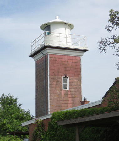
* Westermarkelsdorf (1)
1881 (heightened in 1902). Inactive since 2021. 18 m (58 ft) octagonal brick tower with lantern and gallery, attached to 2-story keeper's house. Tower is painted beige or pale yellow; lantern and gallery painted red. The lighthouse was heightened from 10 m (33 ft) in 1902; the seam between the two sections is clearly visible. The keeper's house is in use as a residence. A 2022 photo is at the top of this page, Werning also has a good photo, Larry Myhre has a photo, Leuchturm-Atlas has a photo, Marinas.com has distant aerial photos, Huelse has a historic postcard view, Andre Brocki has a street view, and Google has a satellite view. The lighthouse was renovated in the fall of 2020. Located just behind the dike on the Markersdorfer Huk, the northwestern point of Fehmarn, marking the western entrance to the Fehmarn Belt. Parking is available nearby. Site open, tower closed. Operator: WSA Ostsee. ARLHS FED-261.
* Westermarkelsdorf (2)
2021. Active; focal plane about 25 m (82 ft); white or red light, depending on direction, 2.5 s on, 7.5 s off. 24 m (79 ft) round tower carrying a 2-story watch room. Tower painted white; lower story of the watch room painted red. Trabas has a photo by Eckhard Meyer, Hartmann has a June 2021 photo, and Esther Hahn has a January 2021 view showing the new and old lighthouses, and Google has a street view. Site open, tower closed. DE 205320; Admiralty C1280; NGA 3164.
* Marienleuchte (2)
1967 (station established 1832). Active; focal plane 39.5 m (130 ft); four short flashes, separated by 2.8 s, every 15 s, white or red depending on direction. 33 m (108 ft) round cylindrical reinforced concrete tower with round lantern and gallery. Tower covered with hard fiberboard panels colored with red and white horizontal bands; lantern painted red. Trabas has a photo, Udo Schweda has a 2017 photo, Edgar Huwe has a 2021 photo, a closeup is available, and Google has a satellite view. Located a short distance north of the historic lighthouse (next entry) southeast of the ferry terminal at Puttgarden, where ferries link Fehmarn to Denmark. Site appears open, tower closed. Operator: WSA Ostsee. ARLHS FED-016; DE 205500; Admiralty C1284; NGA 3188.
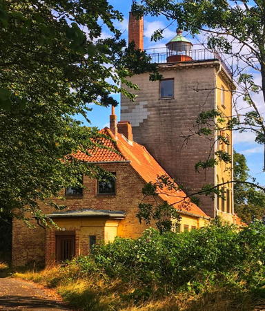
* Marienleuchte (1)
1832 (Danish). Inactive since 1964. 18 m (60 ft) square 4-story brick tower with lantern and chimney on its flat roof, rising from the center of 2-story brick keeper's house. The keeper's house and first story of the tower are built with red brick painted yellow, and the keeper's house has a steeply pitched roof covered by orange tile. The upper three stories of the tower are built with unpainted yellow brick, all except the front side covered with fiberboard panels. The lantern is red with a white roof. Siegfried Bernhard's photo is at right, Werning's page has an excellent photo, Hartmann's page has photos, Wikimedia has photos, Edgar Huwe has a 2021 photo, Larry Myhre has a distant view of both lighthouses, Huelse has a historic postcard view, and Google has a satellite view. Built by Denmark, this historic lighthouse is called Marienleuchte (Maria's Light) because it was inaugurated by the Danish Queen Maria Sophie Friederike on her 61st birthday, 28 October 1832. According to WSA Lübeck the lighthouse was closed in 1964 because it was in poor structural condition and could not be heightened to meet the needs of shipping. Apparently it was sold into private ownership. Clearly endangered: it is not known whether there has been any restoration work done on the building and it does not appear to be in good condition. German Wikipedia's article says it is verfällt zusehends (rapidly disappearing). Located on the Fehmarn Belt at Ohlensburgs Huk, a point about 1.5 km (1 mi) southeast of the ferry terminal at Puttgarden, where ferries link Fehmarn to Denmark. Site possibly open, tower closed. Owner/site manager: private. . ARLHS FED-151.

1832 Marienleuchte Light, Fehmarn, August 2020
Instagram photo by Siegfried Bernhard
Staberhuk
1904. Active; focal plane 25.5 m (84 ft); white or green light, depending on direction, occulting twice, separated by 3 s, every 20 s. 22.5 m (74 ft) round brick tower with lantern and gallery. Tower unpainted, lantern and gallery painted red. A complete light station, with 1-1/2 story keeper's house and other buildings. Werning has a page for the lighthouse, Trabas has a good photo by Stephan Hix, Christoph Heckel has a 2022 photo, Leuchtturm-Atlas also has a photo, Huelse has a historic postcard view, Marinas.com has aerial photos, and Google has a 2021 street view and a satellite view. This lighthouse has two unique features. First, the original yellow brick of the tower did not stand up to the harsh weather of Baltic winters, so it was replaced by red brick, but only on the north and west sides of the tower. As a result, the tower appears from the distance to have a yellow vertical stripe on its seaward (southeast) side. Second, Staberhuk's lantern room and Fresnel lens were originally installed by the English lighthouse agency Trinity House on the Helgoland Light in 1870, while Britain administered that North Sea island (see the North Frisia page); they became available for this tower when the lighthouse on Helgoland was replaced by a taller tower in 1901. Located on the southeastern point of Fehmarn about 5 km (3 mi) southeast of Staberdorf. Site and tower closed (station occupied as a private residence), but there is a good view from the beach; according to the Anke/Jens site one can walk the beach from an army post to the north. Operator: WSA Ostsee. . ARLHS FED-226; DE 205540; Admiralty C1286; NGA 3192.

Lübecker Bucht (Lübeck Bay) Lighthouses
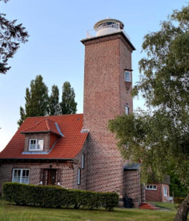
*** Dahmeshöved
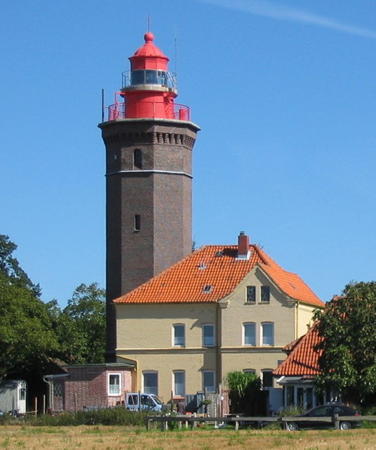
1880 (L. A. Veitmeyer). Active; focal plane 33.5 m (110 ft); three white flashes, separated by 2.2 s, every 12 s. 29 m (95 ft) octagonal cylindrical brown brick tower with iron lantern and watch room and double gallery, attached to one side of a 2-story brick keeper's house. Tower unpainted; lantern and watch room painted red. Keeper's house is currently painted yellow. Malte Tychsen's photo is at the top of this page, Leuchtturm-Atlas has a fine photo of the station, Trabas has Rainer Arndt's closeup photo, Werning's page has a photo, Wikimedia has many photos, Huelse has a historic postcard view, Marinas.com has aerial photos, Tobias Rohde has a street view, and Google has a satellite view. A fine example of German Imperial architecture, this handsome lighthouse is the landfall light for Lübeck, marking the northern entrance to the Lübecker Bucht. In 1939 the Nazi regime added to the station an 18 m (60 ft) octagonal brick watchtower with gallery and a pyramidal tile roof in a style echoing the architecture of the lighthouse. The lighthouse carried red and white horizontal bands for many years; the paint was removed in 1982. The keeper's house is occupied by resident caretakers, and the lighthouse is protected as a historic site. Its name includes an interesting appearance in German of the Danish word høvd for a promentory. Located in the village of Dahmeshöved, about 400 m (1/4 mi) north of the cape of that name, about 6 km (4.5 mi) south of Dahme and 70 km (45 mi) northeast of Lübeck. Site open, tower closed for renovations in 2023 but normally open to guided tours in the afternoons Sunday through Thursday, April through October; on Saturdays the lighthouse is a popular site for weddings. Operator: WSA Ostsee. Site manager: Leuchtturm Dahmeshöved . ARLHS FED-069; DE 205900; Admiralty C1342; NGA 3244.
* Pelzerhaken
1937 (extensively rebuilt 1842 lighthouse). Active; focal plane 21 m (69 ft); white, red, or green light, depending on direction, 3 s on, 4 s off, 3 s on, 10 s off. 19.5 m (64 ft) square cylindrical red brick tower with lantern and gallery, attached to one side of a 2-story brick keeper's house. Tower unpainted; lantern and gallery painted white. The present lighthouse encases the original Danish lighthouse, a 12 m (40 ft) square stone tower. Affixed to the front face of the tower is a bronze eagle with the construction date 1936. A 2020 photo is at right, Werning's page has a good photo, Trabas has a photo by Manfred Schüler, a 2020 photo is available, Wikimedia has photos, Huelse has a historic postcard view of the original lighthouse, Marinas.com has aerial photos, and Google has a satellite view and a street view from the beach. Located on a promentory about 8 km (5 mi) southeast of Neustadt in Holstein, marking the entrance to the Neustädter Bucht. Site and tower closed, but the lighthouse can be seen from nearby. Operator: WSA Ostsee. Site manager: private. . ARLHS FED-188; DE 206100; Admiralty C1346; NGA 3248.

Pelzerhaken Light, Neustadt, August 2020
Google Maps photo by C.

Hansestadt Lübeck Lighthouses

Lübeck is a Hansestadt (Hanseatic city) because it was a leading city of the Hanseatic League, the network of cities that dominated trade in northern Europe in late Medieval and Renaissance times. The city has a population of about 225,000. Travemünde ("mouth of the Trave") is the borough of Lübeck that includes the port district.

Travemünde Lighthouses
**** Travemünde (2)
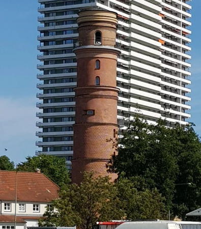
1539 (station established at least by 1316). Inactive since 1972. 31 m (101 ft) round six-stage brick tower with a full gallery at the fifth stage and a half gallery at the third. Apparently the light was shown through a window and there was never a lantern. A photo is at right, Werning has a page with a good photo, Wikimedia has photos, a good 2018 photo is available, Huelse has a historic postcard view, and Google has a good satellite view and a closeup street view. This is (easily) Germany's oldest lighthouse. There is evidence of a light being displayed at Travemünde as early as 1226 and definite record of a lightkeeper being employed from 1316. The original lighthouse was destroyed by Danish troops in 1534. Open fires were displayed for centuries; a lens was added in 1827. The lighthouse remained in service until the construction of a high-rise hotel made it obsolete; the light was then moved to the roof of the hotel and the old light station became a museum. A restoration of the tower was completed in 2003. Located in downtown Travemünde on the north side of the entrance to the river Trave, the inner harbor of Lübeck. Site open; museum and tower open daily April through October. Site manager: Alter Leuchtturm Travemünde. ARLHS FED-241. .
* Travemünde (3)
1974. Active; focal plane 114.5 m (376 ft); flash every 5 s, white or red depending on direction. 113 m (371 ft) high-rise hotel building; the light is displayed from the northernmost corner of the roof. Germany's highest light. Leuchtturm-Atlas has a nice photo showing the hotel looming over the old lighthouse, Werning has a photo, Lightphotos.net has a closeup photo of the light, Trabas has a photo, and Google has a satellite view. Located on the waterfront in Travemünde. Site and building open, light enclosure closed. Operator: WSA Ostsee. Owner/site manager: Maritim Strandhotel Travemünde. ARLHS FED-276; DE 206500; Admiralty C1360; NGA 3304.
#Travemünde Nordmole (1)
1967 (station established 1952). Demolished in 2012. This was a 9 m (30 ft) round masonry tower with lantern and gallery. Jan Koch has a photo, Werning has a photo, and a history of the station is available. By day, the tower presented black and white horizontal bands. The two white bands were translucent glass panels; with light shining through these panels the tower displayed two brightly and continuously illuminated white bands in addition to the red and green directional lights. A round rubblestone beacon with a ball topmark was built on the pier in 1925 and a light was added to this tower in 1952. In 1961 the mole was extended and a "temporary" light placed at its end; the old beacon was removed in 1964. The 1967 lighthouse was demolished and replaced with a temporary post light on 6 December 2012; Anke and Jens have a photo (third photo on the page) of that light. Formerly located at the end of the north mole at the mouth of the river Trave in Travemünde.

Travemünde Alter Leuchtturm, Travemünde, 2021
Instagram photo by a&efotoblog
* Travemünde Nordmole (3)
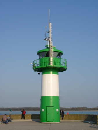
2013. Active; focal plane 10 m (33 ft); light occulting once every 4 s, red or green depending on direction. 9 m (30 ft) round cylindrical steel tower, painted green with one broad white horizontal band. Rosa-Maria Rinkl's photo is at right, Trabas has a closeup photo by Capt. Peter Mosselberger, Lightphotos.net has a photo, René Dickelt has a 2022 photo, and Google has a street view and a satellite view. Rainer Lott and Steffi Esch also have a closeup photo taken in June 2013; the temporary light was still standing at that time. Located at the end of the north mole at the mouth of the river Trave in Travemünde; accessible by walking the mole. Site open, tower closed. Operator: WSA Ostsee. . ARLHS FED-240; DE 206680; Admiralty C1362; NGA 3308.
* Feuerschiff (Lightship) Fehmarnbelt
1908. Decommissioned 1984. 45.4 m (149 ft) steel lightship; light displayed from a four-legged tower with lantern and gallery amidships. 5th order Fresnel lens. Hull painted red, superstructure white, light tower gold. A page for the ship has a good photo, a 2021 photo is available, Christian Schlichte has a street view, and Bing has a satellite view. The ship served most of its career on various stations in the North Sea, but it ended on the Fehmarnbelt station off Fehmarn. After its retirement, the ship appeared in a movie Das Feuerschiff; then it was sold at a bargain price to a preservation society that had formed in Lübeck. The ship is operational; during the summer it sails among the ports of Germany's Baltic coast appearing at various harbor festivals and other special events. When not at sea it is moored on the Museumshafen waterfront in downtown Lübeck. Site open, ship open to group tours by reservation. Owner/site manager: Feuerschiff für Lübeck e.V. Site manager: Museumshafen Lübeck. . ARLHS FED-141.
* Priwall Oberfeuer
1966. Active; focal plane 24 m (79 ft); white light, 2 s on, 1 s off, 5 s on, 1 s off. 21 m (69 ft) square skeletal tower painted white and carrying a triangular white daymark, point down. Trabas has a closeup photo and Google has a satellite view. This is an approach range for the Trave entrance. The front light is on a 13 m (43 ft) mast. Located on the east side of the river Trave, on the Mecklenburger Landstraße east of the Pötenitzer Weg. Site open, tower closed. DE 207021; Admiralty C1370.1; NGA 3300.

Information available on lost lighthouses:

  • Travemünde Südmole (1959-1967). A small lighthouse replaced a post light established in 1936. Trabas has a photo of the slender post light currently on the mole. Admiralty C1363.1.

Notable faux lighthouses:


Nordmole Light, Travemünde, May 2016
Wikimedia Creative Commons photo by Rosa-Maria Rinkl

Adjoining pages: North: Southeast Jylland | Northeast: Sjælland | East: Mecklenburg

Return to the Lighthouse Directory index | Ratings key

Posted April 9, 2005. Checked and revised May 10, 2024. Lighthouses: 38; lightships: 3. Site copyright 2024 Russ Rowlett and the University of North Carolina at Chapel Hill.