Lighthouses of Denmark: Southeast Jylland

The Kingdom of Denmark (Danmark in Danish), located at the mouth of the Baltic Sea, includes the north-pointing peninsula of Jylland (Jutland) in the west and a large number of islands to the east. The capital, Copenhagen, is on the island of Sjælland. Other major Danish islands include Fyn (between Sjælland and Jylland), Lolland and Falster (south of Sjælland) and Bornholm (farther east in the Baltic). The Skaggerak is a sound separating Jylland from Norway to the northwest, while the Kattegat separates Jylland from Sweden to the northeast.

This page covers lighthouses of the southeast coast of Jylland in the Syddanmark (South Denmark) Region. This coast faces a series of narrow sounds and channels known collectively as the Lille Bælt (Little Belt), separating Jylland from the island of Fyn. The Syddanmark Region has many other lighthouses described on the West Coast and Fyn and Langeland pages.

For many years Denmark and Germany struggled over the control of Schleswig-Holstein, the region at the base of the Jylland peninsula. Danish Slesvig or Sønderjylland (South Jylland) was under German control from 1864 until 1920. As a result, many lighthouses on the east side of Jylland, from Årosund southward, are of German origin. The German names for these lighthouses, if known, are in curly brackets {}.

The Danish word for a lighthouse is fyr. The front light of a range is the forfyr and the rear light is the bagfyr. Næs is a cape, odde a narrow promontory or isthmus, ø is an island, bælt ("belt") is a strait, and havn is a harbor.

Danish aids to navigation are maintained by the Danish Maritime Authority (Søfartsstyrelsen).

ARLHS numbers are from the ARLHS World List of Lights. DFL numbers are from the Dansk Fyrliste. Admiralty numbers are from volume C of the Admiralty List of Lights & Fog Signals. U.S. NGA List numbers are from Publication 116.

General Sources
Danske Fyrtårne
A comprehensive site on Danish lighthouses by Ole Henrik Lemvigh, with many photos; the text is entirely in Danish.
Online List of Lights - Denmark Baltic Sea
Photos of active aids to navigation maintained by Alexander Trabas.
Leuchttürme.net - Dänemark
A fine web site by Malte Werning, with excellent photos.
Leuchtturmseiten von Anke und Jens - Denmark
Photos of more than 100 Danish lighthouses, with notes in English.
Dänische Leuchttürme
Photos of more than 175 Danish lighthouses posted by Klaus Huelse.
Denmark Lighthouses
Photos by Larry Myhre.
Lighthouses in Denmark
Photos by various photographers available from Wikimedia.
World of Lighthouses - Denmark
Photos by various photographers available from Lightphotos.net.
Lighthouses in Denmark
Aerial photos posted by Marinas.com.
Dänische Leuchttürme auf historischen Postkarten
Historic postcard views posted by Klaus Huelse.
Danske Fyrskibe og deres Historie
Comprehensive information on Danish lightships (in Danish), posted by the group managing the Horns-Rev.
Dansk Fyrliste 2022
Official Danish light list (in .pdf format); the list also includes lights of Greenland and Faroes.
OpenSeaMap
Navigational chart for Denmark.


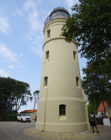
Nordborg Light, Als, August 2018
photo copyright Heather Craven; used by permission
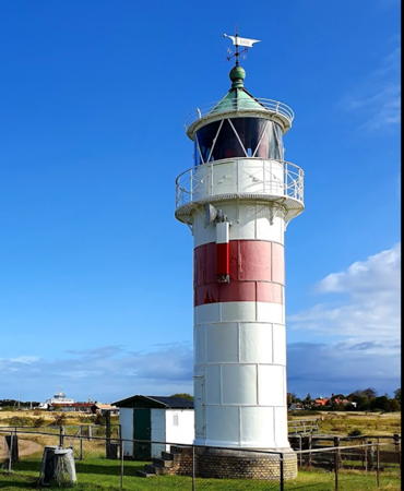

Årø Light, Årø, September 2019
Google Maps photo by Kenn Madsen
Lille Bælt (Little Belt) Lighthouses

Fredericia Lighthouses
Between Fredericia on the mainland and Middelfart on the island of Fyn the Lille Bælt (Little Belt) is a narrow and twisting but busy waterway crossed by two bridges including the Nye Lillebæltsbro (New Little Belt Bridge) on the E20 motorway.

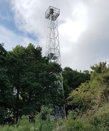
* Vejle Range Rear (2)
Date unknown (station established 1901). Active; focal plane 25 m (82 ft); red light, 2 s on, 2 s off. 28 m (92 ft) square skeletal mast carrying a red triangular daymark, point down. Trabas has Eckhard Meyer's photo and Google has a street view but the slender tower is hard to see in Google's satellite view. Huelse has a historic postcard view of the original lighthouse. Vejle, a city of nearly 60,000 residents at the head of the Vejle Fjord, is the council seat of the Syddanmark region. The front light is on an 18 m (59 ft) skeletal mast. Located at the head of the main harbor basin in Vejle. Site open, tower closed. DFL-3930a; Admiralty C0900.1; NGA 2468.
Trelde Næs
1990 (station established 1916). Active; focal plane 26 m (85 ft); white, red or green light depending on direction, 1 s on, 1 s off. 21 m (69 ft) square skeletal tower with gallery, painted white. Beate Broscheit's photo is at right, Anke and Jens have a page for the light, Trabas has Eckhard Meyer's closeup photo, Iben Nymand Boesen has a 2018 photo, Isak Skovgaard Nielsen has a 2023 photo, and Google has a satellite view. The lighthouse replaced a series of small beacons that have stood on this cape; it was built on a German cannon foundation from World War II. A historic photo of a 1930s-era beacon is available. Located on a sharp promontory at the south side of the entrance to Velje Fjord and the north side of the entrance to the Lille Bælt, about 15 km (9 mi) northeast of Snoghøj. Site status unknown (the site appears to be private property). ARLHS DEN-097; DFL-3942; Admiralty C0894; NGA 2460.
* Snoghøj (2)
1946 (station established 1935). Active; focal plane 6 m (20 ft); white, red or green light, depending on direction, occulting once every 5 s. 4 m (13 ft) square brick building, painted white with a red horizontal bar on the seaward side. The light is displayed through a rectangular window. Peter Kromann has a 2022 photo, Huelse has a photo, Trabas has a similar photo, and Google has a satellite view. This light guides ships northbound in the Lille Bælt approaching the narrows at Snoghøj, where two bridges connect Fyn to the mainland. A photo of the original light is available. Located near the shore in a residential neighborhood on the west side of Snoghøj. Site open, tower closed. ARLHS DEN-098; DFL-4094; Admiralty C0936; NGA 2540.
* Børup Nord (2)
1945 (station established 1900). Inactive since 2003. 7 m (23 ft) 2-story masonry keeper's house; the lights were displayed through a rectangular second floor window at the east end of the house. House painted white with a red tile roof; there is also a red horizontal bar under the window that displayed the light. Google has a satellite view. In 2003 the active light (focal plane 9 m (30 ft); white, red or green light, depending on direction, 2 s on, 2 s off) was moved to a short post about 30 m (100 ft) east of the house; this was required by a minor change in the line of the range. Northbound ships follow the line of this light and then turn to starboard to follow the line of the Snoghøj light. Trabas has Ina Rendtel's photo of the new light. Located on the shore at the end of the Røjborgvej, about 1.8 km (1.1 mi) west of Snoghøj. Site and tower closed (private property). ARLHS DEN-211. Active light: DFL-4100; Admiralty C0934; NGA 2544.

Trelde Næs Light, Fredericia, September 2018
Google Maps photo by Beate Broscheit
Børup West (3)
1946 (station established 1900). Active; focal plane 5 m (16 ft); white, red or green light, depending on direction, 2 s on, 2 s off. 6 m (20 ft) square 2-story tower; the lights are displayed through a rectangular second floor window. Lighthouse painted white with a red horizontal bar under the window displaying the light. Trabas has a photo and Google has a satellite view. This light guides southbound ships as they pass under the older Lille Bælt bridge at Snoghøj. The original light was replaced by a mast light in 1935; that light was sabotaged by resistance forces during World War II to hamper German shipping in the channel. Located about 250 m (820 ft) west of the Børup Nord lighthouse and 300 m (660 ft) northeast of the Damgård light. Site and tower closed (private property). ARLHS DEN-212; DFL-4080; Admiralty C0938; NGA 2548.
Damgård (2)
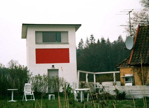
1946 (station established 1935). Active; focal plane 7 m (23 ft); white, red or green light, depending on direction, occulting once every 5 s. 7 m (23 ft) square 2-story tower; the lights are displayed through a rectangular second floor window. Lighthouse painted white with a red horizontal bar under the window displaying the light. A 1-1/2 story keeper's house, painted yellow with a brown tile roof, stands adjacent to the lighthouse. Trabas has a photo, Huelse also has a photo (seen at right), Peter Aaroe has a 2007 photo, and Google has a satellite view. This directional light guides southbound ships as they pass under the older Lille Bælt bridge at Snoghøj. The original lighthouse was destroyed in World War II. Located next to the Børup West light. Site and tower closed (private property). ARLHS DEN-166; DFL-4086; Admiralty C0944; NGA 2552.

Damgård Light, Fredericia
photo copyright Klaus Huelse; used by permission

Kolding Lighthouse
* Drejensodde
Date unknown (station established 1900). Active; focal plane 4 m (14 ft); white, red or green light, depending on direction, occulting once every 5 s. 4 m (13 ft) square wood building, painted green with white trim. The lights are displayed through a small window. Trabas has a photo and Google has a street view and a satellite view. This directional light guides ships approaching the harbor of Kolding, on the west side of the Lille Bælt. Located on a point of land at the end of the Drejensvej, about 6 km (3.5 mi) east of Kolding on the north side of the entrance to Kolding Fjord. Site open, tower closed. ARLHS DEN-099; DFL-4140; Admiralty C0956; NGA 2572.

Haderslev Lighthouses
* Årøsund (3)
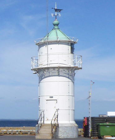
1905 (German) (station established 1777). Active; focal plane 9 m (30 ft); white, red or green light, depending on direction, occulting once every 5 s. 10 m (33 ft) round cylindrical cast iron tower with lantern and gallery. Lighthouse painted white; lantern roof painted green. Wolfgang Pehlemann's photo is at right, Werning has a page for the lighthouse, Anke and Jens also have a page with photos, Trabas also has a good photo, Peter Holmboe has a 2016 closeup, Huelse has a historic postcard view, and Google has a street view and a satellite view. One of a series of small cast iron towers prefabricated by the German firm Pintsch in Fürstenwalde. Located on the south mole at Årøsund. Accessible by walking the mole. Site open, tower closed. . ARLHS DEN-100; DFL-4274; Admiralty C0970; NGA 2620.
* Årø {Aarö}
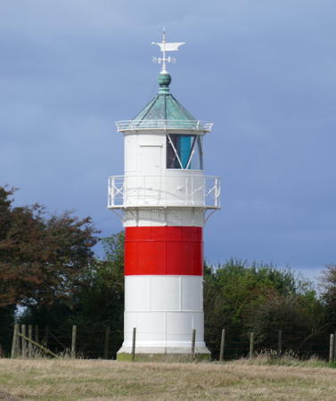
1905 (German). Active; focal plane 12 m (39 ft); white, red or green light, depending on direction, 1 s on, 1 s off. 13 m (43 ft) round cylindrical cast iron tower with lantern and gallery. Lighthouse painted white with a single red horizontal band; lantern roof painted green.Kenn Madsen's 2019 photo is at the top of the page, Thorkild Sørensen has a good 2009 photo, Anke and Jens have a page for the lighthouse, Trabas also has a good photo, Huelse has a postcard view, and Google has a satellite view. One of a series of small cast iron towers prefabricated by the German firm Pintsch in Fürstenwalde. Årø is an island off Årøsund, separated from the mainland by a channel 500 m (0.3 mi) wide. Located on the west side of the island, guiding ships through the channel. Site open, tower closed. . ARLHS DEN-072; DFL-4285; Admiralty C0969; NGA 2628.

Årøsund Light, Haderslev, 2018
Wikimedia Creative Commons photo by Wolfgang Pehlemann

Åbenrå Lighthouse
* Åbenrå (Sønderstrand)
1927. Inactive since 2017. 4 m (13 ft) square cylindrical wood tower on a brick foundation; the lights were displayed through a square window. Trabas also has a good photo and Google has a street view and a satellite view. The light guided ships entering the harbor of Åbenrå from the Lille Bælt. It was repainted in 2018. Located on the Kystvej at the foot of the Flensborgvej in Åbenrå. Site open, tower closed. ex-DFL-4310; ex-Admiralty C1048; ex-NGA 2656.

Sønderborg Municipality Lighthouses

Als Area Lighthouses
Als (Alsen in German) is an island just off the eastern base of the Jylland peninsula. The island is about 30 km (20 mi) long from northwest to southeast, and it has a population of about 60,000. At its south end, at Sønderborg, it is separated from the mainland by a narrow strait crossed by two bridges. The northwestern end of the island is also accessible by ferry from Blans, and another ferry crosses the Lille Bælt to Bøjden on the island of Fyn. Als was annexed by Germany in 1864 but it was returned to Denmark following a referendum in 1920.

*
Ballebro
1904 (German). Active; focal plane 11 m (36 ft); white, red or green light, depending on direction, 1 s on, 1 s off. 6 m (20 ft) round cast iron tower with lantern and gallery. Lighthouse painted white with one red horizontal band under the gallery; the lantern dome is dark gray metallic. Werning has a fine photo, Trabas also has a good photo, Anke and Jens have a page with photos, Dorte Asbæk Hansen has a 2020 closeup, Marinas.com has aerial photos, Huelse has a closeup and a historic postcard view, and Google has a satellite view. One of a series of small cast iron towers prefabricated by the German firm Pintsch in Fürstenwalde. The light guides ferries crossing the Als Fjord from Hardeshøj on Als to Blans on the mainland. Located on the Ballebrovej about 200 m (660 ft) east of the ferry terminal at Blans. Site open, tower closed. . ARLHS DEN-101; DFL-4500; Admiralty C1066; NGA 2704.
* Nordborg {Augustenhof}
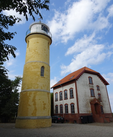
1902 (German). Active; focal plane 27 m (89 ft); white, red or green light, depending on direction, occulting once every 5 s. 20 m (66 ft) round cylindrical masonry tower with lantern and gallery. Lighthouse painted yellow; lantern roof is gray metallic. The station has a large 2-1/2 story hipped-roof keeper's house. Heather Craven's photo is at the top of this page, Jan Lillebæk has a 2021 photo, Myhre has a 2008 photo, Lemvigh has a page with photos, Trabas has Eckhard Meyer's closeup, Werning also has a photo, Marinas.com has aerial photos, Huelse has a closeup and a historic postcard view, and Google has a street view and a satellite view. Located off the Augustenhofvej at the northwestern end of Als, on the west side of Købingsmark and about 4 km (2.5 mi) northwest of Nordborg. Site open; Anke/Jens report that that lighthouse is open for climbing, but if so no schedule information is available. . ARLHS DEN-029; DFL-4300; Admiralty C1030; NGA 2652.
* Tranerodde (Traner Odde)
1905 (German). Active; focal plane 12 m (39 ft); white, red or green light, depending on direction, 1 s on, 1 s off. 10 m (33 ft) round cylindrical cast iron tower with lantern and gallery. Lighthouse painted white with a single red horizontal band; lantern roof is gray metallic. Jens Bludau's photo is at right, Werning's page has a good photo, Myhre has a good photo, Rikarda Schulz has a 2021 photo, Trabas has Eckhard Meyer's closeup, Huelse also has a closeup, Lemvigh has a page with photos, Marinas.com has aerial photos, and Google has a satellite view. One of a series of small cast iron towers prefabricated by the German firm Pintsch in Fürstenwalde. Located on a promontory on the northeast side of Als, at the end of the Skærveagervej about 3 km (2 mi) east of Danfoss. Site open, tower closed. . ARLHS DEN-106; DFL-4415; Admiralty C1032; NGA 2712.
* Taksensand (2)
1953 (station established 1905). Active; focal plane 15 m (49 ft); white, red or green light, depending on direction, occulting twice every 12 s. 19 m (62 ft) round stone tower with lantern and gallery, mounted on a rubblestone pier. The lighthouse stands on a beach and is often surrounded by water; access to the tower is by a footbridge from a low bluff behind the beach. Lighthouse painted white; the lantern roof is greenish metallic. Anke and Jens have a page with photos, Dennis Lind has a 2021 photo, Bjarne Nielsen has a 2007 photo, Werning has a photo, Trabas has Eckhard Meyer's photo, Marinas.com has aerial photos, and Google has a satellite view. The original German lighthouse was 32 m (105 ft) tall; Huelse has a historic postcard view of that tower. It was probably damaged during World War II, but in any case it was replaced by the shorter tower in 1953. Located on the beach about 1 km (0.6 mi) west northwest of Fynshav, the terminal for ferries to Fyn. Site open, tower closed. . ARLHS DEN-107; DFL-4420; Admiralty C1034; NGA 2716.

Tranerodde Light, Als, September 2017
Wikimedia Creative Commons photo by Jens Bludau
* Mommark Vestmole (1)
1904 (German). Inactive. 7 m (23 ft) tapered concrete tower with gallery; lantern removed. Lighthouse painted white. The light has been replaced by small post light (focal plane 9 m (30 ft); continuous red light). Abandoned for years, the lighthouse has been refurbished and repainted recently. Thomas Fischer has a photo of the two Mommark lighthouses, Werning has a photo, Huelse has a photo, Birgit Weller has a distant 2023 photo, and Google has a street view and a satellite view. Mommark's small harbor is the terminal of a ferry to the island of Æro; Huelse has a postcard view of a ferry sailing between the two lighthouses. Located at the end of the short west mole at Mommark; Site open, tower closed. Active light: DFL-4451; Admiralty C1042; NGA 2852.
* Mommark Havn (Ostmole) (1)
1904 (German). Inactive. 7 m (23 ft) tapered concrete tower with gallery; lantern removed. Lighthouse painted white. The light has been replaced by small post light (focal plane 9 m (30 ft); red flash every 3 s). Abandoned for years, the lighthouse has been refurbished and repainted recently. Roland Schneider has a 2021 photo, Thomas Fischer has a photo of the two Mommark lighthouses, Werning has a photo, Huelse has a photo, and Google has a street view and a satellite view. Located at the end of the east mole at Mommark. Site open, tower closed. . Active light: DFL-4453; Admiralty C1046; NGA 2856.
* Gammel-Pøl {Polshuk}
1906 (German). Active; focal plane 20 m (66 ft); white, red or green light, depending on direction, occulting three times every 15 s. 10 m (33 ft) round cylindrical cast iron tower with lantern and gallery. Lighthouse painted white with a single red horizontal band; lantern roof is gray metallic. Werning has an excellent photo, Myhre has a closeup photo, Trabas has Eckhard Meyer's photo, Anke and Jens have a page with photos, a 2021 photo is available, Marinas.com has aerial photos, and Google has a satellite view. One of a series of small cast iron towers prefabricated by the German firm Julius Pintsch in Fürstenwalde. Polshuk is the German name for the cape. The lighthouse originally carried the front light of a range; it was converted to a directional light in 1975. Located at the southeastern tip of Als, 3 km (1.8 mi) east of Neder Lysabild. Site open, tower closed. . ARLHS DEN-108; DFL-4475; Admiralty C1100; NGA 2872.
**** Kegnæs {Kegnäs} (2)
1896 (German) (station established 1845). Active; focal plane 32 m (105 ft); white, red or green light, depending on direction, occulting once every 5 s. 18 m (59 ft) round masonry tower with lantern and gallery. Lighthouse painted pale yellow, lantern dome black. Two 1-1/2 story keeper's houses, painted yellow with red tile roofs, are occupied by teams of six keepers. Heather Craven's photo is at right, Myhre has a 2008 photo, Trabas has a good closeup by Eckhard Meyer, Werning has a fine photo, the Anke/Jens site also has good photos, Oliver Tisemann has a 2021 photo, Mette Lienhøft has a 2022 photo, Marinas.com has aerial photos, and Google has a satellite view. The lighthouse was restored in 1973 and again in 1995; it was in 1995 that the tower was painted for the first time. Kegnæs is an island just south of Als, connected to Als by a causeway. The lighthouse is built on the southernmost tip of Kegnæs, close to the south end of the causeway; it marks the north side of the entrance to the Flensborg Fjord. Site open; tower open daily May through September. Owner/site manager: Sønderborg Municipality (Kegnæs Fyr). . ARLHS DEN-019; DFL-4570; Admiralty C1104; NGA 2876.

Kegnæs Light, Kegnæs, August 2018
photo copyright Heather Craven; used by permission

Flensborg Fjord Lighthouses
The Flensborg Fjord (Flensburger Förde in German and Flensburg Firth in English) forms part of the border of Denmark and Germany. Lighthouses on the German side are listed on the Germany: Flensburg to Lübeck page. These three cast iron range lighthouses on what is now the Danish side were prefabricated by Sohns Maschinen Fabrik.

Skodsbøl Forfyr
1896 (German). Active; focal plane 11 m (36 ft); white light, 1 s on, 1 s off. 8 m (26 ft) round cylindrical cast iron tower with lantern and gallery. Lighthouse painted white with one red horizontal band; the lantern dome is also painted red. Lemvigh has a page with good photos, Werning has a fine photo, Trabas has a closeup, a 2022 photo is available, Marinas.com has aerial photos, and Google has a satellite view. The range guides westbound ships on a northward reach around the peninsula of Schausende on the German side. The rear light is on a skeletal mast. Located just off the Brovej (highway 8) between Skodsbøl and Røndbjerg. The lighthouse is in a farm field; it can be seen easily from a walking track of the Egeskovvej. Site and tower closed. ARLHS DEN-104; DFL-4585b; Admiralty C1136; NGA 2932.
* Lågemade Forfyr
1896 (German). Active; focal plane 13 m (43 ft); red light, 1 s on, 1 s off. 8 m (26 ft) round cylindrical cast iron tower with lantern and gallery. Lighthouse painted white with one red horizontal band; the lantern dome is also painted red. Lemvigh has a page with good photos, Andreas Köhler has a 2022 photo, Trabas has Rainer Arndt's photo, Myhre has a photo, Marinas.com has aerial photos, and Google has a street view and a satellite view. The range guides westbound ships as they make their turn around the peninsula of Schausende on the German side. The rear light is on a skeletal mast. Located on the waterfront near the intersection of the Sundgade and the Fjordvej in Egernsund about 2 km (1.2 mi) west of the Skodsbøl Forfyr. Site open, tower closed. ARLHS DEN-109; DFL-4596b; Admiralty C1140; NGA 2952.
* Rinkenæs {Rinkenäs} Forfyr
1896 (German). Active; focal plane 10 m (33 ft); white or green light, depending on direction, light, 1 s on, 1 s off. 8.5 m (28 ft) round cylindrical cast iron tower with lantern and gallery. Lighthouse painted white with one red horizontal band; the lantern dome is also painted red. Helge Lassen Holm's 2022 photo is at right, Lemvigh has a page with good photos, Trabas has Rainer Arndt's photo, Chris Kunz has a closeup photo, Sten Hartmann has a 2021 photo, Werning also has a photo, and Google has a satellite view. The range guides westbound ships as they make their turn around the peninsula of Schausende on the German side. The rear light is on a skeletal mast. Located about 1.2 km (3/4 mi) southeast of Rinkenæs, halfway between Dalsgård and Sandager. Site open, tower closed. . ARLHS DEN-102; DFL-4590b; Admiralty C1166; NGA 2944.

Lågemade Forfyr, Egernsund, May 2022
Google Maps photo by Helge Lassen Holm

Information available on lost lighthouses

Notable faux lighthouses:

Adjoining pages: North: East Central Jylland | East: Fyn and Langeland | South: Flensburg to Lübeck | West: Jylland West Coast

Return to the Lighthouse Directory index | Ratings key

Posted December 16, 2006. Checked and revised April 6, 2024. Lighthouses: 21. Site copyright 2024 Russ Rowlett and the University of North Carolina at Chapel Hill.