Lighthouses of Germany: Mecklenburg

The Federal Republic of Germany (Bundesrepublik Deutschland in German) occupies a central location in northern Europe with two coastlines, one facing northwest on the North Sea and the other facing northeast on the Baltic Sea. The country's history is long and complex. The large number of historically independent German regions came together in 1871 to form the German Empire. The Empire became a republic after World War I (1914-18). After World War II (1939-45) Germany was divided into two countries, the German Federal Republic in the west, usually called West Germany, and the Communist-led German Democratic Republic in the east, usually called East Germany. After the Communist government collapsed the Federal Republic reunified the nation in October 1990.

This page lists lighthouses of the Baltic coast in Mecklenburg, part of the state of Mecklenburg-Vorpommern. Before the creation of the German Empire in 1871 all of this region was part of the Kingdom of Prussia. From the end of World War II until the reunification of Germany in 1991 it was part of the German Democratic Republic (East Germany). Mecklenburg includes the western portion of Mecklenburg-Vorpommern (the Wismar, Warnemünde, and Rostock areas), while Vorpommern (Lower or Western Pomerania) includes the eastern section from the Stralsund area to the Polish border.

Interest in lighthouses is strong in Germany and most of the towers are in good condition. A federal law provides blanket protection to historic lighthouses. There is concern, however, that many of the lights may be deactivated in the coming years as navigators depend less and less on them.

In German, a lighthouse is a Leuchtturm ("light tower"), plural Leuchttürme. The front light of a range is the Unterfeuer and the rear light is the Oberfeuer. Modern range lighthouses are crowned by a topmark: a large, distinctive structure that serves to mark the range clearly in the daytime. In German Insel is an island, Riff is a reef, Kap is a cape, Bucht is a bay, and Hafen is a harbor. The Baltic Sea is known in Germany as the Ostsee (East Sea).

Lighthouses in Germany are operated by the regional harbor authority, called the WSA (Wasserstraßen- und Schifffahrtsamt). Recently the two WSA's for the Baltic coast, WSA Lübeck and WSA Stralsund, were merged to form the WSA Ostsee. The WSA's are linked to and regulated by a federal agency, the Wasserstraßen- und Schifffahrtsverwaltung des Bundes (WSV).

ARLHS numbers are from the ARLHS World List of Lights. DE numbers are the German light list (Leuchtfeuerverzeichnis) numbers as noted on Erich Hartmann's website. Admiralty numbers are from volume C of the Admiralty List of Lights & Fog Signals. U.S. NGA List numbers are from NGA Publication 116.
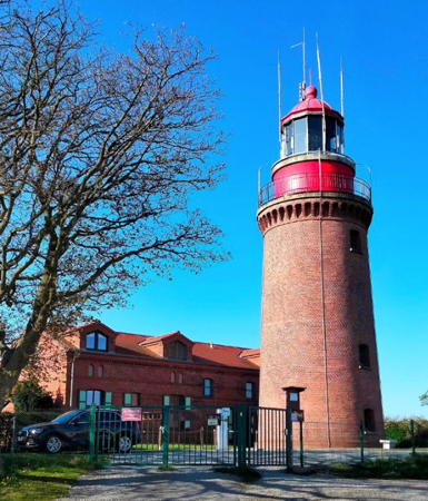

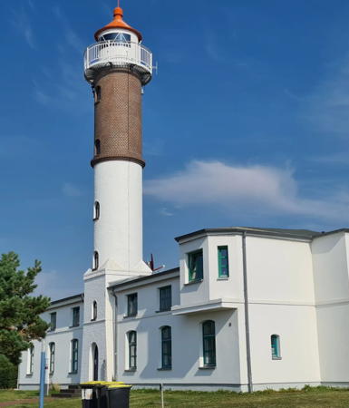
Buk Light, Bastorf, June 2023
Instagram photo by Edda Stern
General Sources
Online List of Lights - Germany - Central Baltic Sea
Photos by various photographers posted by Alexander Trabas.
Leuchttürme und Leuchtfeuer an der Ostsee
Photos and information posted by Erich Hartmann, a contributor to the Online List of Lights.
Leuchtturm-Atlas
A large site with excellent photos and information on nearly all German lighthouses, maintained by Frank and Birgit Toussaint.
Leuchttürme.net - Deutschland
Photos and notes by Malte Werning.
Leuchtturmseiten von Anke und Jens - Germany Baltic Sea
This site has photos and information on many of the lights.
Germany Lighthouses
Photos by Larry Myhre.
Lighthouses in Mecklenburg-Vorpommern
Photos by various photographers available from Wikimedia.
World of Lighthouses - Germany
Photos by various photographers available from Lightphotos.net.
Lighthouses in Germany
Aerial photos posted by Marinas.com.
Deutsche Leuchttürme/Feuerschiffe
Photos posted by Klause Huelse, who also has a page of historic postcard views.
Interessengemeinschaft Seezeichen e.V.
Germany's national lighthouse preservation organization.
GPSNauticalCharts
Navigational chart information for Germany.
Navionics Charts
Navigational chart for Germany.

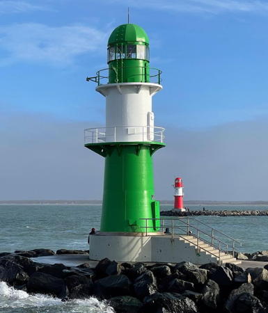
Westmole (left) and Ostmole Lights, Warnemünde, January 2024
Instagram photo by Annette Boll

Nordvestmecklenburg District Lighthouses

Western Schönberger Land Lighthouses
These lighthouses are on the east bank of the Trave River opposite Lübeck.

[Teschow Range Front]
Date unknown. Active; focal plane 32 m (105 ft); white light, 2 s on, 2 s off. Approx. 25 m (82 ft) white mast carrying a triangular daymark, point up. Trabas has Capt. Peter Mosselberger's photo and Google has a satellite view. The range guides vessels on the north-south reach in the Trave between Travemünde and Lübeck. Located in a forest on the northwest coast of the Teschow Peninsula. Site open, tower closed. Admiralty C1366.5.
Teschow Range Rear
Date unknown. Active; focal plane 42 m (138 ft); white light, 2 s on, 2 s off. Approx. 25 m (82 ft) white skeletal mast carrying a white rectangular daymark. Trabas has Hartmann's photo, another photo is available, and Google has a satellite view. Located in a farm field about 300 m (0.2 mi) southeast of the front light. Site open, tower closed. Admiralty C1366.51.

Mecklenburg Bay (Wismar Area) Lighthouses
Wismar is a historic seaport, a former member of the Hanseatic League, about 45 km (28 mi) east of Lübeck. The capital of the Nordvestmecklenburg district, it has a population of about 45,000. The approach to the port is through a series of ranges guiding vessels in the shallow Wismar Bay.

Hohen Wieschendorf Unterfeuer (3?)
Date unknown (station established 1938). Active; focal plane 19 m (62 ft); white light, 3 s on, 1 s off, synchronized with the rear light. 16 m (52 ft) square skeletal tower carrying a white triangular daymark, point up. Trabas has Gerd Liedtke's photo but Google's satellite view seems consistent with the June 2009 photo of a skeletal mast on Hartmann's site. This is an approach range for Wismar. Located on a point of land at Hohen Wieschendorf, about 15 km (9 mi) northwest of Wismar. Accessible by road and a short walk. Site open, tower closed. Site manager: Golfclub Hohen Wieschendorf. ARLHS FED- 356; DE 209860; Admiralty C1382; NGA 3316.
* Hohen Wieschendorf Oberfeuer (2)
1971 (station established 1938). Active; focal plane 39 m (138 ft); white light, 3 s on, 1 s off, synchronized with the front light. 19 m (62 ft) square skeletal tower carrying a white triangular daymark, point down. Trabas has Gerd Liedtke's photo and Google has a satellite view. Located in the village of Hohen Wieschendorf, about 15 km (9 mi) northwest of Wismar. Site open, tower closed. DE 209861; Admiralty C1382.1; NGA 3320.
Wismar Unterfeuer
Date unknown. Active; focal plane 28 m (92 ft); red light, 3 s on, 1 s off. 26 m (85 ft) slender square skeletal tower. Trabas has a photo and the shadow of the tower is seen in Google's satellite view. Located on the west side of the entrance to the Westhafen, an inner harbor basin of Wismar. Site and tower closed by the light can be seen from the neighboring Alter Hafen area. DE 210800; Admiralty C1392; NGA 3372.
* Wismar Oberfeuer
Date unknown. Active; focal plane 46 m (151 ft); red light, 3 s on, 1 s off, synchronized with the front light.43 m (141 ft) slender skeletal tower. Trabas has a photo and the shadow of the tower is seen in Google's satellite view. Located at the rear of the Westhafen. Site open, tower closed; the tower is also easy to see from nearby streets, including the Schiffbauerdamm. DE 210801; Admiralty C1392.1; NGA 3376.
* Walfisch Unterfeuer (relocated to Wismar)
1938 (station established 1906). Inactive since 2000. 14 m (46 ft) cast iron lantern, watch room, and double gallery mounted on a short square skeletal tower; Fresnel lens mounted in the lantern. Lighthouse painted white; lantern roof is green. Hartmann has photos and notes (bottom of the page), Werning also has a good photo, Martin Kalis has a 2020 photo, and Google has a satellite view. This lighthouse formerly stood in the Wismar Bucht south of Poel Island, carrying the front range lights for the inbound Walfisch range and the outbound Poel range. It was replaced and restored for display on the lawn outside the WSA Ostsee district office in Wismar, a port on the southeast side of the Lübecker Bucht in the former East Germany. Trabas has a photo of the current Walfisch Unterfeuer. Located at the end of the Tonnenhofstraße, on the east side of the harbor entrance. Site open, tower closed. Owner/site manager: WSA Ostsee. ARLHS FED-250; ex-DE 210400; ex-Admiralty C1387.8; ex-NGA 3344.
* Timmendorf (Timmendorf-Poel)
1872. Active; focal plane 21 m (69 ft); white, red, or green light, depending on direction, 3 s on, 3 s off. 21 m (69 ft) round cylindrical brick tower with lantern and gallery, rising from the center of the front of a 2-story brick pilot house. Building painted white, except that the upper 1/3 of the tower is unpainted brown brick; lantern painted white with a red roof. 3rd order Fresnel lens in use since 1931. Bernd-Andreas Müller's photo is at right, Werning has a good photo, Trabas has a closeup photo by Stephan Hix, Wikimedia has several photos, Andreas Lieske has a 2021 photo, Marinas.com has aerial photos, Thomas Schwebel has a 2017 street view, and Google has a satellite view. The tower was heightened in 1931 by the addition of an additional section, which was not painted and remains unpainted today, so that from the sea the lighthouse presents itself as white with a single broad brown horizontal band. Huelse has a historic postcard view of the tower at its original height. After the reunification of Germany WSA carried out an extensive restoration of the building in 1996-97; it was necessary to replace much of the brickwork in the tower. The lighthouse was also recognized as a protected historic site. The lighthouse was repainted and refurbished in 2011, as seen in a photo by Rainer Lott and Steffanie Esch. Located on the waterfront in Timmendorf, a fishing port on the west side of the island of Poel. Site open, tower closed. Operator: WSA Ostsee. ARLHS FED-236; DE 209700; Admiralty C1386; NGA 3328.

Timmendorf Light, Timmendorf, August 2022
Instagram photo by Bernd-Andreas Müller
* Gollwitz West
1995. Active; focal plane 23 m (75 ft); white, red, or green light, depending on direction, occulting once every 5 s. 21 m (62 ft) triangular skeletal tower with gallery, painted white. Trabas has a photo by Ulrich Bode and Google has a street view and a satellite view. This directional light guides vessels leaving Wismar on a west to east jog in the channel. Located about 200 m (220 yd) west of the historic lighthouse (previous entry). Site open, tower closed. Operator: WSA Ostsee. DE 209200; Admiralty C1398; NGA 3330.
* Gollwitz Nord (Unterfeuer) (2)
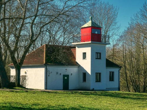
1953 (station established 1929). Reactivated (1996); focal plane 13 m (42 ft); white, red, or green light, depending on direction, 2 s on, 2 s off. 7.5 m (25 ft) square cylindrical concrete tower with square lantern and gallery centered at the front of a 1-story concrete keeper's house. The building is unpainted white concrete; lantern painted red. A 2022 photo is at right, Leuchtturm-Atlas has a good closeup photo, Trabas also has a good closeup, Patrick Scholl has a 2011 photo, Werning has a good photo, Larry Myhre has a photo, and Google has a street view and a satellite view. The lighthouse shines a directional light over a very narrow arc to the north northwest defining the proper approach to Poel Island and Wismar for ships arriving from the Baltic. The DDR (East German) government built this rather plain lighthouse to replace the 1929 skeletal tower. In 1956 a skeletal tower behind the lighthouse carried the front light of a range. Finding the building in poor repair after reunification, WSA Lübeck renovated it in 1996, removed the mast and daymarker and replaced the range with a directional light in the lantern. Located about 800 m (1/2 mi) west of the village of Gollwitz, near the northeastern end of the island of Poel. Site open, tower closed. Operator: WSA Ostsee. . ARLHS FED-092; DE 209230; Admiralty C1398.5; NGA 3331.

Gollwitz Nord Light, Gollwitz, March 2022
Google Maps photo by Peter A.

Rostock District and City Lighthouses

**** Buk (Bastorf)
1878. Active; focal plane 95.5 m (313 ft); four long (2 s) flashes, white or red depending on direction, separated by 7 s, every 45 s. 21 m (69 ft) round brown brick tower with lantern and gallery, connected by a covered passageway to the 2-story brick keeper's house. Original 2nd order Fresnel lens in use. Buildings unpainted; lantern painted red. Edda Stern's 2023 photo is at the top of this page, a 2021 photo is available, Werning has a photo, Leuchtturm-Atlas has a great photo, Wikimedia has numerous photos, Trabas has a closeup photo of the tower by Capt. Peter Mosselberger, Huelse has a historic postcard view, Mike Henniger has a street view, and Google has a satellite view. Built by the former Grand Duchy of Mecklenburg-Schwerin, this lighthouse is a beautiful example of German Imperial lighthouse architecture and is recognized as a protected historic site. On Germany's generally low Baltic coastline this lighthouse is elevated above the sea higher than any other. Marking the eastern entrance to the broad Mecklenburger Bucht, it was built as the landfall light for Wismar and a guide for ships westbound for Lübeck. The tower was formerly painted red with a white horizontal stripe, but the paint was removed in 1993. WSA Lübeck restored the station in several projects completed in 1999 and has recently opened this historic lighthouse to the public for the first time. Located on a bluff about 1 km (0.6 mi) from the Baltic at Bastorf, near Ostseebad Kühlingsborn, about 65 km (40 mi) northeast of Wismar. Site open, tower open daily year round. Operator:WSA Ostsee. Site manager: Leuchturm Bastorf . ARLHS FED-058; DE 212000; Admiralty C1400; NGA 3412.
Nienhagen
2010 (tower built 1998). Active; focal plane 9 m (30 ft); five yellow flashes every 20 s. 9 m (30 ft) scientific station mounted on a platform supported by three piles. Entire structure painted yellow. Trabas has Hartmann's photo and Google has a satellite view. Operated by the state environmental agency, the station monitors an artificial reef created to improve fishing in the area. Located 1100 m (2/3 mi) off the beach at the resort town of Nienhagen, about 10 km (6 mi) west of Warnemünde. Accessible only by boat. Site open, tower closed. Owner/site manager: Staatliches Amt für Landwirtschaft und Umwelt Mittleres Mecklenburg. DE 212200; Admiralty C1403.

Warnemünde Lighthouses
Warnemünde is a former fishing port and seaport for the city of Rostock 20 km (13 mi) to the south. Today it is primarily a resort town and ferry port; it also has Baltic Germany's main cruise ship terminal.
**** Warnemünde (2)
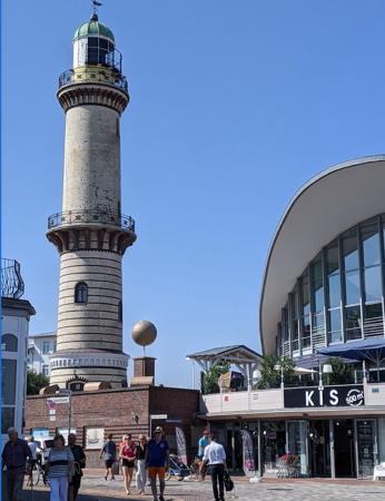
1898 (station established 1836). Active; focal plane 34 m (112 ft); four white flashes every 24 s in a 3+1 pattern, the flashes occuring at 0, 3, 6, and 15 s in the cycle. 31 m (102 ft) round tapered brick tower with lantern and two galleries, one at the top and one in the center of the tower. Tne tower is unpainted very light gray brick but darker brick was used to create a dark band on the lower half of the tower; lantern dome is unpainted green copper. Original 2nd order Fresnel lens in use. Torsten Liederwald's 2020 photo is at right, Trabas has a good photo, Werning also has a good photo, Uwe Seidel has a 2016 street view, an article on the history of the station is available, Wikimedia has numerous photos, and Google has a satellite view. Huelse has a historic postcard view in which the lower half of the tower is painted white. Lights are said to have been displayed at Warnemünde as early as 1348. In 1836 a light was shown from a scaffold atop a waterfront building. The present lighthouse is one of the best known landmarks of the Rostock area. After reunification the lighthouse was leased to a preservation organization for restoration and development as a tourist attraction. Located in a public square in downtown Warnemünde, about 200 m (220 yd) from the west bank of the river Warnow just inside the entrance. Site open; tower open daily Easter Saturday through October 1. Operator:WSA Ostsee Site manager: Förderverein Leuchtturm Warnemünde . ARLHS FED-022; DE 212300; Admiralty C1404; NGA 3428.
* Warnemünde Westmole (3?)
1985 (station established 1877). Active; focal plane 14 m (46 ft); green light, 2 s on, 2 s off. 12 m (40 ft) round metal tower with lantern and double gallery, painted green with a white horizontal band between the galleries. Fog horn (Morse code "WN" every 30 s: short blast, two longs, pause, long, short.) Annette Boll's 2024 photo is at the top of this page, Hartmann has a page for the mole lights, Werning has an excellent photo, Trabas has a closeup, Wikimedia has a photo of the two mole lights in action, a 2020 photo is available, Heinz-Willi Knechten has a street view, and Google has a satellite view. The lighthouse was relocated in 1998 onto a new arm of the west mole extending slightly to the east of the original mole ending. This lighthouse and its sibling on the east mole are known locally as Die Zwillinge (the twins). The 1963 lighthouse was relocated to a park in Rostock (see below). The history of the mole lights of Warnemünde is quite complex; both moles have been extended several times and there have been several lights on each mole. Michel Forand has a postcard photo showing the situation in 1959, shortly before the 1963 lights were installed, and another postcard view of the older beacons on the west mole. Located at the end of the west mole at the entrance to the river Warnow in Warnemünde. Accessible in good weather by walking the mole. Site open, tower closed. Operator: WSA Ostsee. . ARLHS FED-258; DE 214310; Admiralty C1405; NGA 3452.

Warnemünde Light, Warnemünde, August 2020
Google Maps photo
by Torsten Liederwald
* Warnemünde Westmole (2?)
1963. Inactive since 1985. 12 m (40 ft) round metal tower with lantern and double gallery, painted black with a white horizontal band between the galleries. J. Schildwach has a 2020 photo, Wikimedia has a 2015 photo and a 2013 photo, Hartmann has a photo (second photo on the page), and Google has a satellite view. Originally located at the end of the west mole at the entrance to the river Warnow in Warnemünde; it's not clear why this tower was replaced by an almost identical tower in 1985. Huelse has a historic postcard view of the light on its original station. The older lighthouse was relocated for display in a riverside theme park just off the 105 expressway at Rostock-Schmarl, about 5 km (3 mi) south of Warnemünde. Site open, tower closed. Site manager: IGA Park Rostock.
* Schmarl Unterfeuer
Date unknown. Active; focal plane 20 m (66 ft); white light, 2 s on, 1 s off, 5 s on, 1 s off. 18 m (59 ft) square skeletal tower painted white and carrying a red triangular daymark, point up. Trabas has Eckhard Meyer's photo, Michel Lazar has a street view, and Google has a satellite view. This range guides vessels up the river Warnow. Located on the west side of the river just south of the Schifffahrtsmuseum Rostok. Site open, tower closed. DE 214700; Admiralty C1424.6.
* Schmarl Oberfeuer
Date unknown. Active; focal plane 26 m (85 ft); white light, 2 s on, 1 s off, 5 s on, 1 s off. 23 m (75 ft) square skeletal tower painted white and carrying a red triangular daymark, point up. Trabas has Eckhard Meyer's photo and Google has a satellite view. Located in IGA Park, 220 m (240 yd) southwest of the front light and 150 m (165 yd) south of the relocated Westmole lighthouse. Site open, tower closed. DE 214701; Admiralty C1424.61.
Warnemünde Ostmole (2?)
1903. Inactive since 1963(?). Approx. 6 m (20 ft) round cast iron tower with lantern. Removed in 1998, the tower long stood derelict at the site of a former rail yard on the west side of the inner harbor. Wikimedia has a 2015 photo. The abandoned and unprotected lighthouse was critically endangered. When Andreas Köhler visited in August 2017 he found that the lighthouse had been removed. In May 2019 Manfred Schmidt found that the Schifffahrtsmuseum in Rostock has restored the lighthouse and repainted it with red and white horizontal bands. The lighthouse was placed atop the Deck 9 Bistro in front of the city train station. Carlos Benjamín Zegarra Moretti has a September 2019 video showing the restored lighthouse, Olaf Ebert has a photo, Hartmann has before-and-after photos (bottom of the page) and Google has a satellite view. Site open, tower closed. Site manager: Deck 9 Bistro . ARLHS FED-256.
* Warnemünde Ostmole (3?)
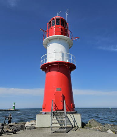
1983 (station established 1877). Active; focal plane 14 m (46 ft); red light, 2 s on, 2 s off. 12 m (40 ft) round metal tower with lantern and double gallery, painted red with a white horizontal band between the galleries. A 2024 closeup is at right, Hartmann has a page for the mole lights, Trabas has a closeup, Werning has a more distant view, Markus Birth has a street view, and Google has a satellite view. The lighthouse was relocated in 1998 when the east mole, originally quite short, was extended to the same length as the west mole. This lighthouse and its sibling on the west mole are known locally as Die Zwillinge (the twins). Located at the end of the east mole at the entrance to the river Warnow in Warnemünde. Accessible in good weather by walking the mole. Site open, tower closed. Operator:WSA Ostsee. . ARLHS FED-257; DE 214330; Admiralty C1405.1.

Ostmole Light (right), Warnemünde, May 2024
Google Maps photo by Alex WPunkt
* Petersdorf Unterfeuer (2)
1999 (station establishment date not known). Active; focal plane 24 m (79 ft); red light occulting once every 4 s, synchronized with the rear light. 21 m (69 ft) round cylindrical tower with lantern and gallery arranged in a large funnel-shaped topmark. Lighthouse painted with red and white horizontal bands. Werning's photo is at right, Trabas has a photo and Google has a satellite view and a distant street view from the waterfront. The Petersdorf range guides ships across the wide portion of the Warnow estuary to Rostock's new international port; ferries leave here for Gedser, Denmark; Trelleborg, Sweden; and various locations on the upper Baltic including St. Petersburg, Russia. Located at the head of Becken (Basin) B in Petersdorf, on the east side of the Warnow north of Rostock. Site open, tower closed. Operator: WSA Ostsee. ARLHS FED-309; DE 212400; Admiralty C1415; NGA 3432.
* Krummendorf (Petersdorf Oberfeuer) (2)
1999 (station establishment date not known). Active; focal plane 45 m (148 ft); red light occulting once every 4 s, synchronized with the front light. 33 m (108 ft) round cylindrical tower with lantern and gallery arranged in a large funnel-shaped topmark. Lighthouse painted with red and white horizontal bands. Trabas has a photo, Werning has a distant view, and Google has a 2022 street view and a satellite view. This lighthouse is similar to the large range light towers built on the Jade, Weser, and Elbe estuaries on Germany's North Sea coast. Located near Krummendorf 1250 m (3/4 mi) south southeast of the front light. Site open, tower closed. Operator: WSA Ostsee. ARLHS FED-310; DE 212401; Admiralty C1415.1; NGA 3436.
Peez Unterfeuer
1984. Active; focal plane 25 m (82 ft); white light, 2 s on, 2 s off. 24 m (79 ft) square skeletal tower painted white and carrying a red triangular daymark, point up. Trabas has Capt. Peter Mosselberger's photo and Google has a satellite view. This range guides vessels into an industrial harbor on the east side of the Warnow. Located in a field east of the Peez chemical complex. Site status unknown. DE 214600; Admiralty C1421.6.
Petersdorf Unterfeuer
Petersdorf Unterfeuer, Petersdorf
photo copyright Malte Werning; used by permission
Peez Oberfeuer
1984. Active; focal plane 35 m (115 ft); white light, 2 s on, 2 s off. 33 m (108 ft) square skeletal tower painted white and carrying a red triangular daymark, point down. Trabas has a photo and Google has a satellite view. Located in a field 450 m (1/4 mi) east of the front light. Site status unknown. DE 214601; Admiralty C1421.61.

Inland Lighthouses

Rathenow Lighthouse
* Warnemünde Mittelmole (2) (relocated from Warnemünde)
1990 (station established 1903). Inactive since 1998. 9 m (30 ft) hexagonal metal tower with gallery, colored with red and white horizontal bands. Stefan Nitsche has a good 2019 photo, a more distant view is available, Michell Regell has a distant street view, and Google has a street view and a satellite view. This light was prefabricated in Rathenow, a town in Brandenburg west of Berlin, and installed on the middle mole of Warnemünde. Deactivated and removed in 1998, the tower was stored by WSA Stralsund. In 2009 it was returned to Rathenow, where it has been placed in a quiet oxbow loop of the Havel River adjacent to the downtown area. Huelse has a good postcard view of the original Mittelmole lighthouse, and Michel Forand has a second postcard view. Accessible only by boat, but easily seen from every angle. Site open, tower closed. ARLHS FED-255.

Plauer See Lighthouse
*** Plau am See
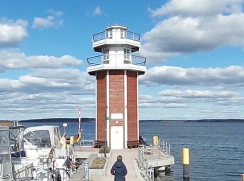
2012. Active (unofficial but charted by Navionics); focal plane 12.5 m (41 ft); white, red or green light, depending on direction, occulting once every 4 s. 13.5 m (44 ft) octagonal wood lighthouse with lantern and double gallery. Gerhard Knöchel has a 2021 photo, Jürgen Treiber also has a photo, and Google has a street view (a portion is at right) and a satellite view. The lighthouse was built as part of a project to reconstuct the town pier. The Plauer See is a lake about 14 km (9 mi) long and up to 5 km (3 mi) wide; Plau am See is a resort town on the west side of the lake. Located at the end of the town pier. Site open and visitors can climb to the lower gallery.
 

Plau am See Light, Plau am See, April 2021
Google Maps street view by THW
 

Information available on lost lighthouses:

Notable faux lighthouses:

Adjoining pages: North: Denmark: Sjælland Region | East: Vorpommern | West: Flensburg to Lübeck

Return to the Lighthouse Directory index | Ratings key

Posted April 9, 2005. Checked and revised May 17, 2024. Lighthouses: 25. Site copyright 2024 Russ Rowlett and the University of North Carolina at Chapel Hill.