Lighthouses of Denmark: East Central Jylland

The Kingdom of Denmark (Danmark in Danish), located at the mouth of the Baltic Sea, includes the north-pointing peninsula of Jylland (Jutland) in the west and a large number of islands to the east. The capital, Copenhagen, is on the island of Sjælland. Other major Danish islands include Fyn (between Sjælland and Jylland), Lolland and Falster (south of Sjælland) and Bornholm (farther east in the Baltic). The Skaggerak is a sound separating Jylland from Norway to the northwest, while the Kattegat separates Jylland from Sweden to the northeast.

This page covers lighthouses of the eastern coast of Jylland in the Midtjylland (Central Jutland) Region. This coast faces the waters of the Kattegat sound. Midtjylland has additional lighthouses on the North Sea coast described on the Denmark West Coast page.

The Danish word for a lighthouse is fyr or fyrtårn. The front light of a range is the forfyr and the rear light is the bagfyr. Næs is a cape, odde a narrow promontory or isthmus, ø is an island, bugt is a bay, rev is a reef, fjord is an inlet, and havn is a harbor.

Danish aids to navigation are maintained by the Danish Maritime Authority (Søfartsstyrelsen).

ARLHS numbers are from the ARLHS World List of Lights. DFL numbers are from the Dansk Fyrliste. Admiralty numbers are from volume C of the Admiralty List of Lights & Fog Signals. U.S. NGA List numbers are from Publication 116.

General Sources
Danske Fyrtårne
A comprehensive site on Danish lighthouses by Ole Henrik Lemvigh, with many photos; the text is entirely in Danish.
Online List of Lights - Denmark East
Photos by various photographers posted by Alexander Trabas.
Leuchttürme.net - Dänemark
A fine web site by Malte Werning, with excellent photos.
Leuchtturmseiten von Anke und Jens - Denmark
Photos of more than 100 Danish lighthouses, with notes in English.
Dänische Leuchttürme
Photos of more than 175 Danish lighthouses posted by Klaus Huelse.
Denmark Lighthouses
Photos by Larry Myhre.
Lighthouses in Denmark
Photos by various photographers available from Wikimedia.
World of Lighthouses - Denmark
Photos by various photographers available from Lightphotos.net.
Lighthouses in Denmark
Aerial photos posted by Marinas.com.
Dänische Leuchttürme auf historischen Postkarten
Historic postcard views posted by Klaus Huelse.
Danske Fyrskibe og deres Historie
Comprehensive information on Danish lightships (in Danish), posted by the group managing the Horns-Rev.
Dansk Fyrliste 2022
Official Danish light list (in .pdf format); the list also includes lights of Greenland and Faroes.
OpenSeaMap
Navigational chart information for Denmark.


Sletterhage Light, Helgenæs, February 2021
Google Maps photo
by Jørgen Jacobsen

Norddjurs: Mainland Lighthouses
The municipality of Norddjurs occupies the northern half of the Djurs Peninsula, a region projecting eastward about 35 km (22 mi) into the Kattegat.

Udbyhøj (1)
1894. Inactive since 2003. 6 m (20 ft) 1-1/2 story keeper's house; the light was displayed from a "bay window" lantern on the second floor level. House painted yellow, lantern roof red. Anke and Jens have a page with photos, a historic photo is available, and Huelse also has a photo. After deactivation the lighthouse was sold as a private residence. Site and tower closed (private property). ARLHS DEN-088.
Udbyhoj (2)
2003 (station established 1894). Active; focal plane 33 m (108 ft); white, red or green light, depending on direction, occulting once every 5 s. 4.5 m (15 ft) round cylindrical tower; the light is shown through a slit-style window at the top. The upper half of the tower is painted red, the lower half white. Trabas has Huelse's photo. In Google's satellite view it appears that the light may become obscured by surrounding trees. This directional light guides ships approaching the entrance to the Randers Fjord. Located adjacent to the historic lighthouse, at the end of a lane off highway 531, about 800 m (1/2 mi) south of Udbyhoj. Site and tower closed (private property). DFL-1640; Admiralty C0176; NGA 1936.
* Gjerrild (2)
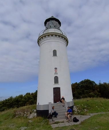
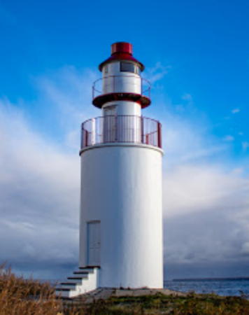
1946 (station established 1895). Active; focal plane 27 m (89 ft); four flashes every 20 s, white or green depending on direction. 11 m (36 ft) rectangular cylindrical tower with lantern and gallery, painted white. Ove Christensen's 2020 photo is at right, Myhre has a photo, Trabas has a good photo by Eckhard Meyer, Anke and Jens have a page with photos, Huelse has a photo, Steen Møller Laursen has a 2020 view across a field of flowers, and Google has a street view and a satellite view. This lighthouse also guides southbound ships around the end of the Djurs peninsula. Located on the Teglværksvej, on the east side of Nordstrand, near Gjerrild. Site and tower closed but the light can be seen from the road. . ARLHS DEN-089; DFL-1865; Admiralty C0200; NGA 2008.
Gjerrild (1) (?)
1895. Inactive since 1946. Approx. 4 m (13 ft) wood building with a rounded front; the light was shown theorugh a window. A historic photo is available. The lighthouse was sold and in 1985 it was acquired by the Gjerrild and Omegns Borgerforening, a social club in the area. It was relocated and used as an ice cream parlor for outdoor parties. A photo from the early 1990s is available. It is not known if the light survives.

Gjerrild Light, Norddjurs, February 2020
Instagram photo by Ove Christensen
* Fornæs (2)
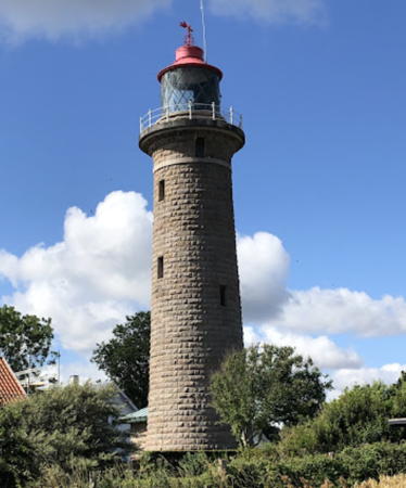
1892 (station established 1839). Active; focal plane 32 m (105 ft); white flash every 20 s. 27 m (89 ft) round granite tower with lantern and gallery. The tower is unpainted; lantern painted red. 1-1/2 story keeper's house and other light station buildings. Olav Sejeroe's 2023 photo is at right, Laila Pilgaard Plesner has a 2021 photo, Trabas has a photo by Klaus Kern, Anke and Jens have a page with photos, Myhre has a photo, Wikimedia has a 1980 photo by Jens Bludau, Huelse has a historic postcard view, and Google has a satellite view. This seems to be one of the least well known major lighthouses of Denmark, perhaps because it's a bit difficult to find. Fornæs is the easternmost point of Jylland, at the end of the Djurs peninsula. The light station is now occupied by an architecture and engineering firm. Located on the point of the cape, at the end of the Fornæsvej, about 4 km (2.5 mi) northeast of the Grenå waterfront. There's no marking at the entrance to the Fornæsvej from the Stenmarksvej. Site open during business hours, tower closed. Site manager: Arkikon. . ARLHS DEN-008; DFL-1870; Admiralty C0204; NGA 2012.
* Grenå Havn Vest (relocated)
1933. Inactive. 7 m (23 ft) round cast iron cylindrical tower, painted white with two red horizontal bands. The light was shown through a window at the top of the tower. Huelse has a photo and a second photo. The light was still in service in 1965; we don't know when it was deactivated. An identical light on the east pier has disappeared. The light was first relocated from its original location on the west breakwater to stand at the yacht harbor on the south side of Grenå. In 2012 it was relocated again; it now stands on the Rolshojvej north of the harbor area. Lightphotos.net has a photo of the lighthouse at its current location and Google has a street view and a satellite view. Site open, tower closed. ex-Admiralty C0212.
[Grenå Bagfyr]
Date unknown. Active; focal plane 33 m (108 ft); green light, 1 s on, 1 s off. 30 m (98 ft) triangular skeletal mast. Trabas has Eckhard Meyer's photo and Google has a satellite view and a distant street view. This is the entrance range for the harbor; the front light is on an 11 m (36 ft) skeletal mast. Located in a commercial area adjacent to the harbor. Site status unknown. DFL-1875a; Admiralty C0207.1.
* Grenå Havn
Date unknown. Active; focal plane 20 m (66 ft); white, red or green light depending on direction, 2 s on, 2 s off. 18 m (59 ft) square skeletal tower. Trabas has a photo and Google has a street view and a satellite view. Located on the waterfront in Grenå harbor. Site open, tower closed. DFL-1877; Admiralty C0209; NGA 2020.

Fornæs Light, Grenå, July 2023
Google Maps photo by Olav Sejeroe

Norddjurs: Anholt Lighthouses
Anholt is a small island in the center of the Kattegat, roughly halfway between the Danish and Swedish shores. Due to its strategic location it has often been the object of military action; during the Napoleonic Wars it was occupied by Britain from 1808 to 1814. The island has a permanent population of about 150 and is accessible by passenger ferry from Grenå. It is attached administratively to the Norddjurs municipality.

* Anholt
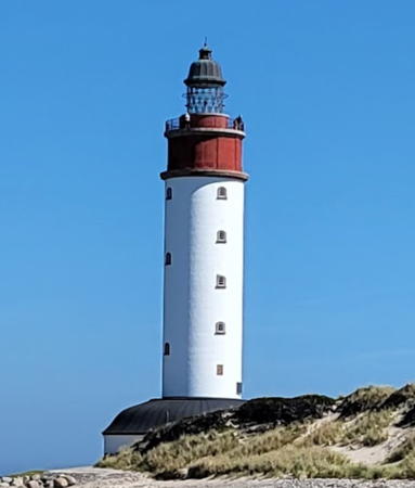
1788. Active; focal plane 40 m (131 ft); white flash every 15 s. 42 m (138 ft) round cylindrical masonry tower with lantern and gallery. Tower painted white; watch room and lantern base painted red; lantern dome is black. Claus Hansen's 2022 photo is at right, Robert Jacobsen has a photo, Huelse has a good photo, Trabas has a photo by Karl-Heinz Wellm, a sunset photo is available, Vivian Hansen has a 2021 closeup, and Huelse has a historic postcard view. This historic lighthouse guides ships approaching the Sound and entering the Baltic. Unfortunately, it is probably endangered: Google's satellite view shows that it is almost in the water. The brickwork, windows and doors of the lighthouse were restored in a major project in 2017; Jacobsen has a photo showing this work in progress. Located at the eastern end of the island, a desert region known for its unusual plant and animal life. Access to this ecologically sensitive area is restricted, but it appears that tours to the lighthouse are available. Site open with restrictions, tower closed. . ARLHS DEN-068; DFL-1020; Admiralty C0164; NGA 1976.
* Anholt Havn (1) (relocated)
1903. Inactive since 2016. 8 m (26 ft) round cast iron tower with lantern and gallery, painted red. This lighthouse was built on the main breakwater of Anholt. A photo of the light the light in its original location is available, Huelse has a historic postcard view, and Google has a distant 2010 street view. In February 2016 the lighthouse was lifted by a crane and placed beside a restaurant on the quay. Jakob Kjærgaard has a 2017 photo, John Boes has a 2021 photo, and Google has a satellite view. Located on the waterfront at Anholt Havn. Site open, tower closed.
[Anholt Havn (2)]
2016. Active; focal plane 8 m (26 ft); red flash every 3 s. 7 m (23 ft) round cylindrical red fiberglass tower. Trabas has Eckhard Meyer's photo and Google has a satellite view. Located at the end of the north outer breakwater at Anholt Havn. Site status unknown. DFL-1840; Admiralty C0166; NGA 1980.

Anholt Light, Anholt, August 2022
Google Maps photo by Claus Hansen

Syddjurs Lighthouses
As its name suggests the municipality of Syddjurs occupies the southern half of the Djurs Peninsula.

Hjelm
1856. Active; focal plane 61 m (200 ft); white, red or green light, depending on direction, 4 s on, 4 s off. 18 m (59 ft) round brick tower with lantern and gallery, attached by covered passageways to two 1-1/2 story brick keeper's houses. Lighthouse painted white, lantern dome red. A photo from a 2018 Google street view is at right, Trabas has a photo, Anke and Jens have a page with distant views, Huelse has a closeup photo and a historic postcard view, Marinas.com has aerial photos, and Google has a satellite view. Hjelm is an uninhabited island in the southwestern Kattegat about 5 km (3 mi) southeast of Elsegårde and 10 km (6 mi) southeast of Ebeltoft. The word hjelm means helmet, referring to the shape of the island. Located at the highest point of the island. Accessible only by boat. Site status unknown. ARLHS DEN-070; DFL-1900; Admiralty C0262; NGA 2208.
[Ebeltoft Havn West Mole]
Date unknown. Active; focal plane 6 m (20 ft); green flash every 5 s. 4 m (13 ft) hexagonal wood tower painted white with a narrow green horizontal band. Alexander Grütter's photo shows both breakwater lights, Andreas Köhler has a closeup, Trabas has a photo, and Google has a satellite view. Located at the end of the west (really south) breakwater of Ebeltoft harbor. The end of the breakwater does not appear walkable. Site open, tower closed. DFL-2084; Admiralty C0776.4; NGA 2244.
* [Ebeltoft Havn North Mole]
Date unknown. Active; focal plane 6 m (20 ft); red flash every 5 s. 4 m (13 ft) hexagonal wood tower painted white with a narrow red horizontal band. Alexander Grütter's photo shows both breakwater lights, Kent Jakobsen has a 2021 photo, Trabas has a photo, and Google has a satellite view. Located at the end of the north breakwater of Ebeltoft harbor. Accessible by walking the pier. Site open, tower closed. DFL-2083; Admiralty C0776.3; NGA 2248.
* Ebeltoft Vig (2)
1921 (station established 1883). Active; focal plane 13 m (43 ft); white, red or green light, depending on direction, occulting once every 5 s. 6 m (20 ft) square wood tower; the lights are displayed through a square window. Trabas has a photo by Eckhard Meyer, Huelse also has a photo, and Google has a satellite view. Tower painted white with one narrow red horizontal band; the roof is gray. Located on a low hill off Sænkningen in Lyngsbæk Strand, at the north end of Ebeltoft Vig (bay) about 7 km (4.5 mi) west of Ebeltoft. Site open, tower closed. ARLHS DEN-005; DFL-2060; Admiralty C0772; NGA 2220.

Hjelm Light, Hjelm, September 2018
Google Maps street view
by M L
*** Sletterhage (2)
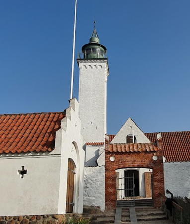
1894 (station established 1872). Active; focal plane 17 m (56 ft); white, red or green light, depending on direction, 7.5 s on, 2.5 s off. 16 m (52 ft) round cylindrical tower with lantern and gallery, attached to a 1-story keeper's house. Lighthouse painted white, lantern white with red horizontal bands. Jørgen Jacobsen's 2021 photo is at the top of this page, Wikimedia has Nils Jepsen's photo, The Sletterhage Fyrs Venner has a 2011 photo, Anke and Jens have a page with photos, Huelse has a closeup photo and a historic postcard view, Trabas has a photo by Eckhard Meyer, Marinas.com has aerial photos, Klaus Hall has a closeup street view, and Google has a satellite view. The original lighthouse, a wood tower, was built by the city of Århus. In 2009 a preservation group Sletterhage Fyrs Venner was formed to work for preservation of the lighthouse and to open it to the public. The lighthouse marks the end of the Helgenæs peninsula about 20 km (13 mi) east of Århus. (The word hage means "hook.") Located on the point of the cape in Slettervang. Site open, tower open daily in July and August and weekends in June, September, and early October. Site manager: Sletterhage Fyrs Venner (Sletterhagefyr). . ARLHS DEN-043; DFL-2090; Admiralty C0786; NGA 2252.

Århus Lighthouses
Århus (now spelled Aarhus officially) is the second-largest city of Denmark with a population around 300,000. It is a major industrial port including Denmark's largest container terminal.

* Århus Havn Forfyr (Range Front)
Date unknown. Active; focal plane 37 m (121 ft); green light, 1 s on, 1 s off. Triangular skeletal mast atop a waterfront apartment building. Trabas has a photo and Google has a street view and a satellite view. This is the approach range for Århus. Located at the foot of Thit Jensens Gade o the Århus waterfront. Site open, tower closed. DFL-2131c; Admiralty C0802.05; NGA 2275.
* Århus Havn Mellumfyr (Range Middle)
Date unknown. Active; focal plane 48 m (157 ft); green light, 1 s on, 1 s off. Light on a 4.5 m (15 ft) skeletal mast atop a 13-story building. Trabas has a photo and Google has a street view and a satellite view. Located on Pier 4 on the northwest side of Århus harbor. Site open, tower closed. DFL-2131b; Admiralty C0803; NGA 2275.1.
* Århus Havn Bagfyr (Range Rear)
Date unknown. Active; focal plane 73 m (240 ft); green light, 1 s on, 1 s off. Light on the steeple of the Sankt Johannes Kirke (St. John's Church). The light is above the clock in Eddy Hansen's closeup photo of the tower, Trabas has Eckhard Meyer's photo, and Google has a street view and a satellite view. Located on Peter Sabroes Gade 1130 m (0.7 mi) northwest of the middle light. Site open, tower closed. DFL-2131a; Admiralty C0804; NGA 2275.2.
* Århus Vestmole
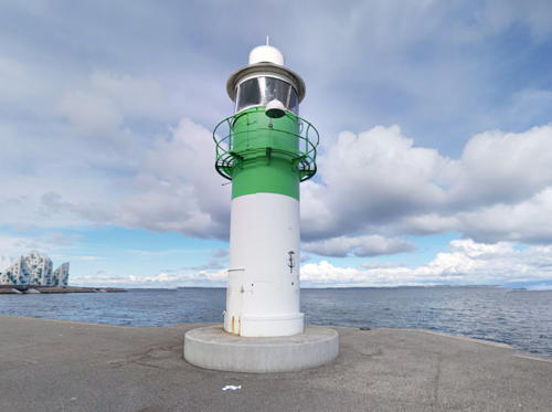
1935. Active; focal plane 8 m (26 ft); green flash every 5 s. 6 m (20 ft) round cylindrical cast iron tower with lantern and gallery, painted white with a broad green horizontal band. Trabas has a photo, a 2022 closeup is available, Christian Witting has a closeup street view (a portion is seen at right), and Google has a street view and a satellite view. Located at the end of the west mole enclosing the traditional inner harbor of Århus. Accessible by walking the pier. Site open, tower closed. DFL-2151; Admiralty C0793; NGA 2282.
Århus Østmole
1935. Active; focal plane 16 m (52 ft); red flash every 5 s. 8 m (26 ft) round cylindrical tower with lantern and gallery, painted white with a single red horizontal band, mounted atop a round stone pier. Trabas has Eckhard Meyer's photo, Huelse has a view from the harbor, Christian Witting has a street view, and Google has a satellite view. Located off the end of the east mole enclosing the traditional inner harbor of Århus. Site and tower closed. Site status unknown. DFL-2150; Admiralty C0792; NGA 2280.
Århus Østhavn (Nordmole)
Date unknown. Active; focal plane 8 m (26 ft); red flash every 3 s. 5 m (17 ft) round metal tower painted white with a red horizontal band. Trabas has a photo and Google has a satellite view. Located on a short breakwater at the tip of the east harbor, which includes the container terminal. Site and tower closed. DFL-2134; Admiralty C0793.5; NGA 2281.

Vestmol Light, Århus, April 2016
Google Maps street view by Christian Witting
Århus Østhavn Østre Bølgebryder
Date unknown. Active; focal plane 8 m (26 ft); red flash every 5 s. 5 m (17 ft) round metal tower painted white with a red horizontal band. Trabas has a distant photo, Michael Tønder Christiansen has a 2021 drone view, and Google has a satellite view. Located on a short breakwater in the inner east harbor. Site and tower closed. DFL-2146; Admiralty C0795; NGA 2289.
Århus Østhavn Forfyr
Date unknown. Active; focal plane 18 m (59 ft); white light, 1 s on, 1 s off. 16 m (52 ft) square skeletal mast with gallery. Trabas has a photo and Google has a satellite view and a street view of the two range lights. Located on the waterfront at the base of the east harbor. Site and tower closed. DFL-2136b; Admiralty C0796; NGA 2286.
Århus Østhavn Bagfyr
Date unknown. Active; focal plane 26 m (85 ft); white light, 1 s on, 1 s off. 23 m (75 ft) square skeletal mast with gallery. Trabas has Eckhard Meyer's photo and Google has a street view and a satellite view. Located besside the Østhavnsvej 207 m (679 ft) southwest of the front light. Site and tower closed. DFL-2136a; Admiralty C0796.1; NGA 2286.1.

Skanderborg Lighthouse
* Grenå Havn Øst (relocated)
1906. Inactive. 7 m (23 ft) round cast iron cylindrical tower, painted with red and white horizontal bands. The light was shown through a window at the top of the tower. Formerly located on the east breakwater at Grenå, the lighthouse was relocated to the grounds of the Skanderborg Music Festival on Skanderborg Lake, south of Skanderborg and west of Århus. We do not know the exact location and the tower has not been found in Google's satellite view. Site open, tower closed. ex-Admiralty C0208.

Odder Lighthouses
* Hov Lystbådehavn (relocated)
1900. Active; focal plane 7 m (23 ft); continuous red light. 5 m (17 ft) round cylindrical cast iron tower, painted red. Red, white and green directional lights were formerly displayed through slit-style window at the top of the tower, but they appear to have been replaced by a lens at the top of the tower. Huelse has a photo, Trabas has a second photo by Huelse, Justas Che has a 2014 photo, and Google has a street view and a satellite view. This light, formerly called Hov Havn, has been relocated from the ferry dock to the nearby yacht harbor. Huelse also has a photo of the light when it was painted white with a red horizontal band, as it was still described by the 2014 NGA List. Note: there is a much better known Hov Fyr on Langeland; see the Fyn and Langeland page. Located on the breakwater of Hov's yacht harbor (lystbådehavn means "pleasure boat harbor"), on the west side of the entrance. Accessible only by boat, although there must be good views from shore. Site open, tower closed. ARLHS DEN-093; DFL-2250; Admiralty C0830.5; ex-NGA 2308.
** Tunø
1801. Active; focal plane 31 m (102 ft); white, red or green light, depending on direction, occulting once every 5 s. 18 m (59 ft) square cylindrical church tower with lantern and gallery. Church and tower painted white, lantern and gallery rail painted green. Josua Walther's 2021 photo is at right, Wikimedia has a photo, Huelse has a good photo of the building, Trabas has a second photo also by Huelse, Vilius Tolsgaard has a photo, Marinas.com has aerial photos, and Google has a street view and a satellite view. Tunø is a small island located between the mainland and the northern part of Samsø; it has a permanent population of about 120 and is accessible by passenger ferry from Hov. The church tower was increased in height in 1820 and again in 1906 to improve visibility of the light. The church caretaker doubles as keeper of the lighthouse and provides guided tours by arrangement, as his time allows. Located in the village of Tunø, at the eastern end of the island. Site open; tower open for an hour each morning late June through mid August and at other times by arrangement with the keeper. . ARLHS DEN-071; DFL-2185; Admiralty C0822; NGA 2300.

Tunø Light, Tunø, September 2021
Google Maps photo by Josua Walther

Samsø Lighthouses
Samsø, one of the two largest islands of the Kattegat, is located about 25 km (15 mi) southeast of Århus. The island is about 15 km (9 mi) in length and has a permanent population of about 4000. It is accessible by ferries from Hov on the mainland south of Århus and from Kalundborg on Sjælland.
*** Vesborg
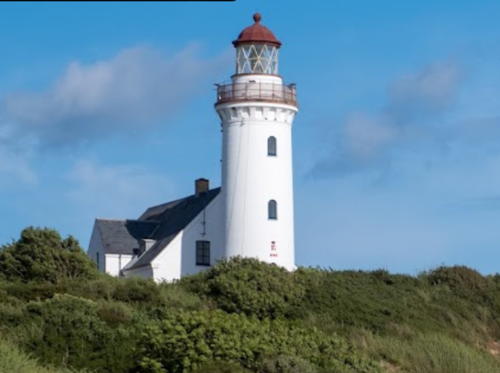
1858. Active; focal plane 36 m (118 ft); white light, with two 2 s occultations every 12 s. 19 m (62 ft) round masonry tower with lantern and gallery, connected by a covered passageway to a 1-1/2 story brick keeper's house. Lighthouse painted white; lantern dome painted red. Morten Øder Hinrichsen's 2023 photo is at right, Huelse has a photo, Trabas has the same photo, Marianne Kjølner has a fine closeup, Søs Nygaard has a view from the sea, Wikimedia has several photos, Frode Marker has a street view, and Google has a satellite view. The keeper's house is available for weekly vacation rentals. Located at Vesborg, near the southwestern corner of Samsø, about 2 km (1.2 mi) south of Kolby. Accessible by road. Site open, tower open April to October. . ARLHS DEN-046; DFL-2230; Admiralty C0842; NGA 2340.
Hatterrev
Date unknown. Active; focal plane 9 m (30 ft); yellow flash every 3 s. 11 m (36 ft) post carrying a lantern and gallery. Entire lighthouse painted yellow. Trabas has a photo by Capt. Peter Mosselberger but the light is not shown in Google's satellite view. This light and the next one guide vessels in the Samsø Belt, the strait separating Samsø from Sjælland. Located about 10 km (6 mi) east of the northeastern tip of Samsø. Accessible only by boat. Site open, tower closed. DFL-1980; Admiralty C1497; NGA 3548.
Hatter Barn
Date unknown. Active; focal plane 9 m (30 ft); four yellow flashes every 10 s. 9 m (30 ft) post carrying a lantern and gallery. Entire lighthouse painted yellow. Trabas has a photo by Capt. Peter Mosselberger but the light is not shown in Google's satellite view. Located about 5 km (3 mi) southwest of the Hatterrev light. Accessible only by boat. Site open, tower closed. DFL-1985; Admiralty C1497.4; NGA 3552.

Vesborg Light, Vesborg, June 2023
Google Maps photo by Morten Øder Hinrichsen

Horsens Lighthouses
Horsens is a city of about 65,000 residents located at the end of a narrow inlet known as the Horsens Fjord.

*
Haldrup Forfyr
1902. Active; focal plane 8 m (26 ft); continuous red light. 8 m (26 ft) square cylindrical 3-story wood tower; the light is shown through a square window on the top floor. Lighthouse painted white; there are three groups of three vertical red bars on the seaward face. Trabas has a photo, Huelse also has a photo, and Google has a satellite view. The range guides ships into the Horsens Fjord. Located in a farm field about 1.25 km (3/4 mi) southeast of the village of Haldrup, on the north side of the fjord. Site open, tower closed. ARLHS DEN-094; DFL-2276b; Admiralty C0866; NGA 2384.
* Haldrup Bagfyr
1902. Active; focal plane 18 m (59 ft); continuous red light. 10 m (33 ft) square cylindrical 3-story wood tower; the light is shown through a square window on the top floor. Lighthouse painted white; there are three groups of three vertical red bars on the seaward face. Trabas has a photo, Huelse also has a photo, and Google has a street view and a satellite view. Located in a farm field about 700 m (0.4 mi) southeast of Haldrup, on the north side of the fjord, 600 m (3/8 mi) northwest of the front light. Site open, tower closed. ARLHS DEN-095; DFL-2276a; Admiralty C0866.1; NGA 2388.
* Horsens Bagfyr
Date unknown. Active; focal plane 22 m (72 ft); red light, 2 s on, 2 s off. 26 m (85 ft) square skeletal tower carrying a red triangular daymark, point down. Trabas has a photo and Google has a street view and a satellite view. The front light is on a slender skeletal mast. Located on Neils Gyldings Gade near Ove Jensens Allé in downtown Horsens. Site status unknown. DFL-2288a; Admiralty C0876.1; NGA 2404.
* Sejet Forfyr
1902. Active; focal plane 3 m (10 ft); continuous green light. 3.5 m (11 ft) square wood building; previously shown through a window, the light is now on the outside of the structure. Lighthouse painted white; there are two vertical red bars on the seaward face. Trabas has a photo, Huelse also has a photo, and Google has a satellite view. Heather Craven and Ian Yarde found the building in poor condition in 2018. Located on the south side of Horsens Fjord 2 km (1.2 mi) northeast of Sejet. Site open, tower closed. ARLHS DEN-168; DFL-2282b; Admiralty C0870; NGA 2392.
* Sejet Bagfyr
1902. Active; focal plane 10 m (33 ft); continuous green light. 5 m (17 ft) square wood building; the light is shown through a window. Lighthouse painted white; there are three vertical red bars on the seaward face. Trabas has a photo, Huelse also has a photo, and Google has a street view and a satellite view. This light was repainted and restored in 2018. Located beside the Nørremarksvej 410 m (1350 ft) southwest of the front light. Site open, tower closed. ARLHS DEN-169; DFL-2282a; Admiralty C0870.1; NGA 2396.

Hedensted Lighthouses
* Hjarnø Forfyr
1902. Active; focal plane 6 m (20 ft); continuous green light. 6 m (20 ft) square cylindrical wood tower; the light is mounted on the outside of the tower near the top. Lighthouse painted white with three vertical red bars on the seaward face. Trabas has Huelse's photo and Google has a distant satellite view. The range guides ships into the Horsens Fjord. The rear light is on a tall communications tower. Located on the northwest side of the island of Hjarnø, which lies in the south side of the entrance to the fjord. The island is accessible by ferry from Snaptun. Site open, tower closed. ARLHS DEN-167; DFL-2270b; Admiralty C0860; NGA 2376.
* Træskohage
1904. Inactive since 1982. 16 m (52 ft) 2-stage round cylindrical tower with lantern and double gallery. Lighthouse painted white; lantern dome painted red. Johannes Laursen's 2018 photo is at right, Huelse has a photo, Marinas.com has aerial photos, and Google has a satellite view. The upper stage was added sometime after 1920. The lighthouse was restored in 2017 by area residents and foundations; Laursen's photo shows the results. Located on a point of land on the north side of the Velje Fjord about 1.6 km (1 mi) west of Fakkegrav. Site open; Craven and Yarde found the tower open in 2018. Owner/site manager: Naturstyrelsen (Danish Nature Agency). ARLHS DEN-096; ex-Admiralty C0898.

Træskohage Light, Fakkegrav, October 2018
Google Maps photo by Johannes Laursen

Information available on lost lighthouses

Notable faux lighthouses:

Adjoining pages: North: Northeast Jylland | South: Southeast Jylland | West: Jylland West Coast

Return to the Lighthouse Directory index | Ratings key

Posted December 16, 2006. Checked and revised March 30, 2024. Lighthouses: 34. Site copyright 2024 Russ Rowlett and the University of North Carolina at Chapel Hill.