Lighthouses of the Dominican Republic

The Dominican Republic (República Dominicana in Spanish) occupies the eastern 2/3 of the Caribbean island of Hispaniola. One of the islands of the Greater Antilles, Hispaniola is east of Jamaica, southeast of Cuba, and west of Puerto Rico. A former Spanish colony, the country was conquered twice by Haiti in the early 1800s but has been independent since 1844. Santo Domingo, the capital and major port of the republic, is also the oldest European settlement in the Western Hemisphere, founded in 1496.

The first lighthouse in the Dominican Republic was at Santo Domingo in 1853, and this was the only lighthouse until the Puerto Plata lighthouse was installed in 1879. Most of the light stations date from the early 1900s but their histories remain poorly known. Many stations are described as established in 1915, but this may be simply the date when they became known in the international light lists.

The Dominican Rpublic is divided into 31 provinces (provincias) plus the National District including the capital of Santo Domingo.

In Spanish the word for a lighthouse is faro, baliza is a beacon, isla is an island, cabo is a cape, punta is a promontory or point of land, péñon is a rock, arrecife is a reef, bahía is a bay, ría is an estuary or inlet, estrecho is a strait, río is a river, and puerto is a port or harbor.

Aids to navigation in the republic are maintained by the General Directorate of Dredging, Dams and Beaconing, a unit of the Dominican Navy.

ARLHS numbers are from the ARLHS World List of Lights. Admiralty numbers are from Volume J of the Admiralty List of Lights & Fog Signals. U.S. NGA numbers are from Publication 110.

General Sources
Online List of Lights - Dominican Republic
Photos by various photographers posted by Alexander Trabas. Some of the photos are by Capt. Peter Mosselberger ("Capt. Peter").
World of Lighthouses - Dominican Republic
Photos by various photographers posted by Lightphotos.net.
Lighthouses in the Dominican Republic
Photos by various photographers available from Wikimedia.
Leuchttürme Mittelamerikas und der Karibik auf historischen Postkarten
Historic postcard views posted by Klaus Huelse.
Lighthouses of the Bahamas and the West Indies
Historic postcard views posted by Michel Forand.
Navionics Charts
Navigation chart for the Dominican Republic.

Faro de Punta Torrecilla
Punta Torrecilla Light, Santo Domingo, September 2009
ex-Flickr Creative Commons photo by Olivier Royer

North Coast Lighthouses

Monte Cristi Province Lighthouses
Puerto Libertador (Pepillo Salcedo) (2)
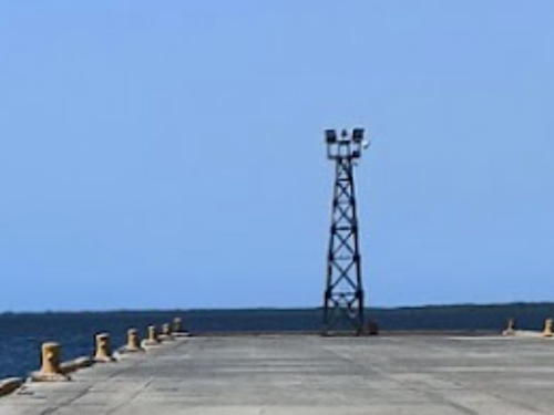
Date unknown (station established 1948). Active; focal plane 15 m (49 ft); one long white flash every 6 s. Approx. 12 m (39 ft) square skeletal tower, painted black. Lisardo Medina has a 2020 view along the pier (a portion is seen at right), Trabas has Capt. Romeo Lucero's photo, Francisco Veloso has a sunset photo of the lighthouse in action, Agustin Jaime Esteban has a distant street view, and Google has a satellite view. The Admiralty reported the light destroyed in 1992, but obviously it has been replaced. Located at the end of the pier at Pepillo Salcedo, a town close to the Haitian border. Site status unknown. Admiralty J5424; NGA 14244.
Cayo Arenas (?)
Date unknown (station established late 1940s(?)). Probably inactive but listed with focal plane 20 m (66 ft); white light, 2 s on, 4 s off. Approx. 17 m (56 ft) "red tower, black lantern," according to NGA. Trabas has Capt. Peter's photo showing the tower overturned, probably by hurricane waves, but Google's fuzzy satellite view suggests that the tower may have been restored. This light was included on international lists as early as 1952. Located on the outermost islet of the Cayos de los Siete Hermanos about 10 km (6 mi) off Punta Rusia, the northwestern corner of the Dominican Republic. Accessible only by boat; transportation is available from Punta Rusia. Site status unknown. Admiralty J5422; NGA 14240.
Isla Cabra (Cayo Pablillo, Isla Cabrita) (1)
Date unknown. Inactive for many years. Approx. 23 m (75 ft) square masonry tower, now collapsing into ruins. A closeup photo is available, Arístides Morán Jiménez has a photo, Tomofumi Masuoka has a drone view, Oniel Acevedo has a street view from atop the new tower, and Google has a satellite view. The island is just northwest of Monte Cristi at the northwestern corner of the country. Located atop a steep bluff on the northwest side of the island. Site open, tower closed. Site manager: Parque National Monte Cristi. ARLHS DOM-004.

Puerto Libertador Light, Pepillo Salcedo, August 2020
Google Maps photo by Lisardo Medina
Isla Cabra (Cayo Pablillo, Isla Cabrita) (2)
Date unknown. Active; focal plane 33.5 m (110 ft); white light, 3 s on, 9 s off. 15 m (49 ft) square skeletal tower. No closeup photo available but Tomofumi Masuoka has a drone view (light to the right of the historic tower), Oniel Acevedo has a street view taken from the top of the tower, and Google has a satellite view. Located atop a forested dune about 100 m (110 yd) southwest of the ruined tower. Site open, and apparently the tower can be climbed. Site manager: Parque National Monte Cristi. Admiralty J5426; NGA 14248.
El Morro de Monte Cristi (?)
Date unknown (1970s?). Inactive at least since 2013. This was a 34 m (111 ft) "white metal" tower on a square base. No photo available but Bing has an indistinct satellite view that may show the tower. This light was dropped from the Admiralty and NGA lists in 2013. Monte Cristi is a steep mountain ridge on a peninsula at the northwestern corner of the Dominican Republic. The lighthouse was on the summit ridge of Monte Cristi. Site manager: Parque National Monte Cristi. ARLHS DOM-002; ex-Admiralty J5427; ex-NGA 14252.

Puerto Plata Province Lighthouses
Puerto Plata is the only major port on the north coast of the Republic. Founded by Spanish explorers in or soon after 1500, the city has a population today of about 350,000.
[Puerto Maimon (Amber Cove)]
2016. Active (privately maintained); focal plane 11 m (36 ft); continuous red, white or green light depending on direction; at the edges of the white sector alternating white and green or white and red lights are seen. 11 m (36 ft) post with a platform holding the lights. Trabas has a closeup photo, Steven Proto has a distant street view and Google has a satellite view. This is the leading light for Amber Cove, a cruise ship terminal and resort operated by Carnival Cruises. Located in the small harbor about 8 km (5 mi) west of Puerto Plata. Accessible only by boat but easily seen from shore. Admiralty J5429.
[Puerto Plata Sector]
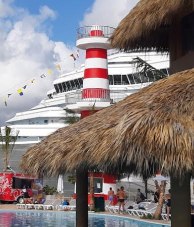
Date unknown. Active; focal plane 11 m (36 ft); red, white, or green light depending on direction. 10 m (33 ft) square concrete pillar painted with narrow red and white horizontal bands. Trabas has a photo by Capt. Theo Hinrichs and Google has a satellite view. This is the leading light for the harbor of Puerto Plata. Located on the waterfront of Puerto Plata about 200 m (220 yd) west of the main pier. Site status unknown. Admiralty J5431.1; NGA 14265.
* Puerto Plata
1879. Reactivated (inactive ?-2002); focal plane 42 m (138 ft); white light, 2 s on, 4 s off. 24 m (80 ft) cast iron skeletal tower with lantern and gallery. Lighthouse painted gold. Access to the lantern is by an exposed spiral stairway. A 2020 photo is at right, Wenceslao Lobato Verdes has a 2018 photo, Carlos Quintanar has a 2022 photo, Trabas has a photo by Capt. Theo Hinrichs, Wikimedia has Juan Espaillat's 2010 photo, William Jenkins has a 2018 street view, and Google has a satellite view. The lighthouse was prefabricated in New York. Gravely endangered by rust and decay, the lighthouse was placed on the World Monuments Fund's 100-most-endangered list in 2000. In 2001 the fund granted $65,000 for restoration of the tower. Additional grants were made by American Express, Metaldom, and the Dominican government. The lighthouse was reactivated on 13 September 2002. The lighthouse appeared to be in good condition in Bash's 2012 photo, but when Rosalie Beasley visited in 2016 she found it in poor condition with much of the stairway missing and no glass or lens in the lantern. The more recent photos indicate that the lighthouse has been repaired and is once again in good condition. Located on the east side of the entrance to the harbor of Puerto Plata on the north coast of the country. Site open, tower closed. Owner/site manager: Ayuntamiento Municipal de Puerto Plata. . ARLHS DOM-003; Admiralty J5430; NGA 14260.

Puerto Plata Light, Puerto Plata, January 2020
Instagram photo by rumbaviajera

Maria Trinidad Sánchez Province Lighthouses
Cabo Francés Viejo (1)
1915. Inactive at least since 1946, probably since the 1930s. Approx. 10 m (33 ft) square concrete tower falling rapidly into ruin. Shiara Ramos has a closeup photo, a 2016 closeup is available, Edwin Rodriguez-Ubinas has a 2023 closeup, and Bing has a satellite view. According to Forand early 20th century light lists have this as a skeletal tower; this might be an error, or the skeletal tower might have been encased in concrete. The cape is a prominent headland at Cabrera, north of Nagua on the north coast of the country. Site open, tower condition unknown. Site manager: Parque National Cabo Francés Viejo.
Cabo Francés Viejo (2)
1930s(?). Inactive, perhaps since 1946. Ruined 24 m (79 ft) white pyramidal concrete tower falling rapidly into ruin. José Nazario Hernandez Mesa's photo of lighthouses two and three is at right, Marvin Noriega has a 2017 photo, Luis Eduardo Gonzalez has a photo, Lubrigomas De Leon has a street view, Nadia de la Rosa's photo and Capt. Peter's photo posted by Trabas show the first two lighthouses, and Bing has a satellite view. This lighthouse was built during the administration of the dictator Rafael Trujillo, who was in power from 1930 until 1961. The Samaná earthquake of 4 August 1946 probably caused the heavy damage to the first two lighthouses, although Forand found that this tower was listed as late as 1952. It was replaced by a 26 m (85 ft) concrete tower that apparently was demolished when the modern tower was built. Site open, tower condition unknown. Site manager: Parque National Cabo Francés Viejo.
#Cabo Francés Viejo (4)
Date unknown. Removed about 2012 but still listed by NGA with focal plane 50 m (164 ft); white light, 2 s on, 8 s off. 26 m (85 ft) square cylindrical skeletal tower, painted white. No lantern. José Nazario Hernandez Mesa's photo of lighthouses two and four is at right, but the street view of Lubrigomas De Leon and J.C. Terrero's 2023 drone view confirm the removal. The lighthouse was built during the administration of President Hipólito Mejía Domínguez (2000-2004). Site open, tower closed. Site manager: Parque National Cabo Francés Viejo. ARLHS DOM-001; ex-Admiralty J5434; NGA 14272.

Samaná Province Lighthouses
Cabo Samaná (2?)
Date unknown (station established 1915). Inactive but listed by NGA with focal plane 141 m (463 ft); white flash every 5 s. 19 m (62 ft) square skeletal tower, painted white. The lighthouse is clearly abandoned in Capt. Peter's photo posted by Trabas, the tip of the tower is seen in Juan Sangiovanni's photo and Google has a satellite view. Cabo Samaná is the tip of the thumb-shaped Samaná Peninsula, which projects eastward parallel to the northeastern coast of the Dominican Republic. The area has been quite remote but a new highway, completed in 2008, has opened it to tourism for the first time. Located atop a very steep bluff at the northeastern tip of the cape; a rugged track reaches the site. Site status unknown. ex-Admiralty J5438; NGA 14280.
Faros de Cabo Frances Viejo
Second and third Cabo Frances Viejo Lights, January 2010
ex-Picasaweb Creative Commons photo
by José Nazario Hernandez Mesa
Punta Balandra
Date unknown. Active; focal plane 47 m (154 ft); white flash every 4 s. "White framework tower," according to NGA, "on bluff," according to the Admiralty. No photo available but Google has a distant satellite view. Located on a promontory on the north side of the entrance to the Bahía de Samaná. Site status unknown. Admiralty J5440; NGA 14284.

La Altagracia Province: North Coast Lighthouse
Punta Nisibon
Date unknown. Active; focal plane 15 m (49 ft); two white flashes every 10 s. 11 m (36 ft) white skeletal tower. No photo available and the tower is not seen in Google's indistinct satellite view. Located on a cape about 65 km (40 mi) northwest of Cabo Engaño, the eastern tip of Hispaniola. Site open, tower closed. Admiralty J5442; NGA 14292.

South Coast (Caribbean Sea) Lighthouses

La Altagracia Province: Cape Engaño Lighthouses
#Cabo Engaño (3?)
1990s (?) (station established 1915). Collapsed cometime between 2007 and 2012. 20 m (66 ft) square steel skeletal tower with gallery. A 2007 distant view is available. Jeff Climie visited the cape in June 2012 and reported that the tower had collapsed. Google's satellite view shows the square concrete foundation of the tower. The original light was on a 46 m (150 ft) skeletal tower. There is a postcard view showing an earlier skeletal tower collapsed and replaced by the second light, a 38 m (125 ft) slender concrete tower. The lighthouse marked the easternmost point of the island, overlooking the Mona Passage. Located on the beach about 2.5 km (1.5 mi) north of the cape. Site open, tower closed.
* Cabo Engaño (4?)
2015 (?). Inactive as of 2021; still listed with focal plane about 9 m (30 ft); white flash every 5 s. Approx. 8 m (26 ft) round fiberglass tower mounted a square skeletal base. Lighthouse painted with brown and white horizontal bands. Serhii Lapchynskiy has a November 2021 photo showing the light largely destroyed. Milvio Nuñez has a 2017 photo of the light, Junior Rafael Ubiera Solano also has a 2017 photo, Trabas has Capt. Peter's very distant view, and the light is barely visible in Google's indistinct satellite view. Located on the very point of the cape. Site open, tower closed. ARLHS DOM-005; Admiralty J5444; NGA 14296.
* Punta Barrachana
Date unknown. Active; focal plane about 40 m (131 ft); red light, 1 s on, 1 s off. Approx. 40 m (131 ft) square skeletal communications tower. Trabas has Capt. Peter's photo and Google has a satellite view. This is primarily an aircraft warning light but it now serves as the navigational marker for Cabo Engaño now that only a small tower is on the point of the cape. Located about 6 km (3.5 mi) southwest of the cape. Accessible by road. Site open, tower closed. Admiralty J5444.5; NGA 14298.
#Boca de Yuma
Date unknown. Listed as active and described by NGA as a "red pyramidal metal tower," but it is clear from many photos and YunChen Liang's 2023 drone view that there is no light at Boca de Yuma. The town faces a sheltered bay about 40 km (25 mi) southwest of Cabo Engaño. Admiralty J5445; NGA 14300.
 

La Altagracia Province: Isla Saona Lighthouses
Isla Saona is an island just off the southeastern tip of Hispaniola. Known for its beaches, the island is popular with vacationers, but much of it is set aside as a nature preserve.
Punta Cana (Isla Saona) (2?)
Date unknown. Active (?); focal plane 32 m (105 ft); white flash every 10 s. Approx. 12 m (39 ft) white concrete tower. Trabas has a photo by Capt. Peter showing the tip of a tower hidden by trees in the center of the photo. A ruined tower is seen in Google's satellite view but the active tower has not been found among the trees. Located at the southeastern tip of the island. Site status unknown. ARLHS DOM-009; Admiralty J5446; NGA 14304.
Punta Laguna
Date unknown. Active; focal plane 14 m (46 ft); white flash every 4 s. Approx. 8 m (26 ft) round concrete tower painted red with a white horizontal band. Trabas has Capt. Peter's photo and Google has a very distant satellite view. Located on a promontory on the south coast of Isla Saona. Site status unknown. ARLHS DOM-010; Admiralty J5447; NGA 14308.

La Romana Province Lighthouses
La Romana is a city of about 150,000 residents and a popular resort area on the far southeast coast of the Republic about 40 km (25 mi) northwest of Isla Saona.

Casa de Campo Breakwater
Date unknown. Active (privately maintained); focal plane about 9 m (30 ft); white light, characteristic unknown. Approx. 7 m (23 ft) square concrete tower on an octagonal base, painted with red and white horizontal bands. John B. Kalla has a 2013 photo, a 2022 closeup is available, Cindy Murillo has a view from the sea, and Google has a satellite view. Located at the end of the breakwater of the Casa de Campo Marina, on the east side of La Romana. Site status unknown. Not listed by the Admiralty.
* La Romana (5?)
Date unknown (late 1960s (?); station established 1913). Active(?); focal plane 27 m (89 ft); red (formerly white) flash every 6 s. Until 2022 this was a 21 m (69 ft) square steel skeletal tower with gallery. Trabas has Capt. Peter's photo, a 2018 drone view is available, and Bing has a satellite view. A major cruise terminal has been built on the point and Google's 2019 street view shows the skeletal tower adjoining the new facilities. Winfried Bremer's January 2023 photo (at right) shows that the skeletal tower is being replaced by a round concrete tower painted with red and white horizontal bands; it was not yet active at that time. Google's satellite view shows the new tower. Located adjacent to the cruise ship terminal on the east side of the entrance to the Río Dulce and the city of La Romana. Site open, tower closed. ARLHS DOM-011; Admiralty J5448; NGA 14312.

La Romana Light, La Romana, January 2023
Google Maps photo by Winfried Bremer
Punta Berroa (Isla Catalina)
Date unknown. Inactive. Approx. 6 m (20 ft) ruined octagonal tower. Capt. Peter Mosselberger's view from the sea is at right and Google has a satellite view. We need information on this abandoned lighthouse. Isla Catalina, an island about 5 km (3 mi) southwest of La Romana, is a popular national park. Located at the southeastern tip of the island. Accessible only by boat. Site status unknown.

San Pedro de Macorís Province Lighthouse
* San Pedro de Macorís (Punta Pescadero) (3?)
Date unknown (station established 1894). Reactivated (?) (reported deactivated in 2013). Approx. 11 m (36 ft) square pyramidal concrete tower. NGA listed the lighthouse as having red and white horizontal bands but it is all white in Alberto Nicanor Rosario's 2012 photo. Aristides Moran has a 2018 photo showing traces of a black spiral band. and Cristopfery González has a 2023 photo showing the light apparently active and painted yellow with a black spiral band (like the Punta Torrecilla lighthouse at Santo Domingo). Bing has a satellite view. Forand found a 1904 listing for the original lighthouse, which was on the west side of the harbor entrance. The light on the east side was established in 1915 and had a height of 7.5 m (25 ft). Located on a promontory on the east side of the entrance to San Pedro de Macorís, a city of nearly 200,000 residents about 40 km (25 mi) west of La Romana. Site open, tower closed. ex-Admiralty J5450; ex-NGA 14316.

Santo Domingo Province: Andrés Lighthouses
* Puerto de Andrés (Leading Light)
Date unknown. Active (?); focal plane about 15 m (49 ft); light characteristic unknown. Approx. 12 m square cylindrical tower painted with red and white horizontal bands. The tower seems to lack a lens in Google's 2019 street view. The light is at the right edge of Nellys del Orbe's photo of the waterfront and Google has an indistinct satellite view. Located on the waterfront of Puerto de Andrés. Site open, tower closed. Admiralty J5455.

Punta Berroa Light, La Romana, May 2019
photo copyright Capt. Peter Mosselberger; used by permission
Cabo Caucedo
Date unknown. Active (privately maintained); focal plane about 25 m (82 ft); continuous red light. Light mounted atop a large fuel tank. Trabas has Capt. Peter's photo and Google has a satellite view. Located at the entrance to the harbor of Andrés. Site and tower closed. Owner/site manager: AES Dominicana. Admiralty J5456.8; NGA 14333.

Santo Domingo City (Distrito Nacional) Lighthouses
The national capital of Santo Domingo, founded by Bartholomew Columbus in 1496, is the oldest city in the Americas and by far the largest city of the Dominican Republic with a metropolitan population of more than 3 million.

*
Punta Torrecilla (Santo Domingo, San Souci, Sans Souci) (3)
Date unknown (1950s?) (station established 1853). Reactivated (reported to have been inactive 1967-1986); focal plane 41 m (135 ft); white light, 2 s on, 2 s off, 2 s on, 4 s off. 38 m (125 ft) square pyramidal concrete tower painted in a black and yellow spiral pattern. The lighthouse has also been painted with orange and dark blue spirals and a USCG photo, taken about 2000, shows black and white spirals. Olivier Royer's photo is at the top of this page, Edwin Rodriguez has a 2019 closeup, Elena Sinalias has a 2009 photo, Trabas has Capt. Peter's photo, Bernd Claußen has a 2003 photo, and Google has a satellite view. Forand has posted an engraving and a postcard view of the original lighthouse, a skeletal tower with lantern and gallery that was of great architectural interest at the time it was built. Huelse also has a postcard view of the first lighthouse. The second light was a 26 m (85 ft) skeletal tower built in 1926. There is a photo of the present tower dated 1959. Located on a promontory east of the entrance to the harbor of Santo Domingo, on the south coast of the country. Site open (the lighthouse is in a city park), tower closed. . ARLHS DOM-006; Admiralty J5457; NGA 14336.
Santo Domingo Range Front
Date unknown. Active; focal plane unknown; continuous green light. Approx. 20 m (66 ft) square white concrete tower carrying a large rectangular daymark colored red with a white vertical stripe. Trabas has Capt. Theo Hinrichs's photo of the two range lights (also seen at right), Google has a street view from the rear and a satellite view. Located off the Avenida España behind the Sans Souci Convention Center. Site status unknown. Admiralty J5458; NGA 14344.
Santo Domingo Range Rear
Date unknown. Active; focal plane unknown; continuous green light. Approx. 25 m (82 ft) square white concrete tower carrying a large rectangular daymark colored red with a white vertical stripe. Trabas has Capt. Theo Hinrichs's photo of the two range lights (also seen at right) and Google has a street view and a satellite view. Located across the Avenida España, 155 m (500 ft) northeast of the front light. Site status unknown. Admiralty J5458.1; NGA 14348.

Santo Domingo Range Lights, Santo Domingo
photo copyright Capt. Theo Hinrichs; used by permission

Santo Domingo Province: Haina Lighthouses
Puerto de Haina (Leading) (1 and 2)
Date unknown. Active; focal plane about 15 m (49 ft); continuous light, white, red or green depending on direction. Approx. 8 m (26 ft) yellow tower. NGA describes a yellow skeletal tower but Trabas has Capt. Peter's photo of the active light on a square yellow concrete post. In Google's satellite view it appears that both towers are present, the skeletal tower to the right of the post light. Río Haina is a busy commercial and industrial port on the west edge of Santo Domingo. Located on the west side of the estuary. Site and tower closed. Admiralty J5463; NGA 14352.

San Cristóbal Province Lighthouse
Punta Palenque
Date unknown. Active; focal plane 14 m (46 ft); white flash every 7 s. 9 m (30 ft) white concrete tower. No photo available Google has an indistinct satellite view. Located on a prominent cape about 8 km (5 mi) east of Nizao. Site status unknown. Admiralty J5466; NGA 14360.

Peravia Province Lighthouse
Punta Salinas
Date unknown. Active; focal plane 30 m (98 ft); white flash every 3 s. 12 m (39 ft) square pyramidal skeletal tower painted with red and white horizontal bands. No closeup photo available but Victor Eduardo Gomez Victoria has a distant street view from the beach and a second street view from atop the tower. Google has a satellite view. Located on a peninsula sheltering the entrance to the Bahía de Ocoa. Site open and apparently the tower can be climbed. Admiralty J5470; NGA 14368.

Barahona Province Lighthouse
#Puerto Viejo de Azua (3?)
Date unknown (around 1990(?); station established 1915). Apparently destroyed. Approx. 15 m (49 ft) square skeletal tower, painted black. The Admiralty listed this light as "destroyed" in 1997, but Michel Forand located a 2005 photo (no longer online). The shadow of the tower is no longer seen in Google's satellite view. The original skeletal tower had a height of 11 m (36 ft), and in the 1970s and 1980s a shorter concrete tower was listed. The modern Port of Azua, built in 1959, is located on the Bahía de las Calderas, about 100 km (60 mi) west of Santo Domingo. Located at the east end of a barrier island that protects the harbor entrance. Accessible only by boat. Site status unknown. ex-Admiralty J5475; ex-NGA 14376.

Pedernales Province Lighthouses
Cabo Beata (?)
Date unknown. Active (?); focal plane 24 m (79 ft); white flash every 9 s. Described by NGA as a concrete tower. No photo available and the tower is not seen in Google's satellite view of the cape. Cabo Beata is the southernmost point of Hispaniola. Site status unknown. Admiralty J5480; NGA 14392.
Isla Alto Velo
Date unknown (station established 1915). Inactive, apparently since the late 1980s, but still listed with focal plane 163 m (535 ft). Approx. 6 m (20 ft) square cylindrical white concrete tower with gallery. Trabas has Capt. Peter's photo (also seen at right), a distant photo is available, and Bing has a satellite view. NGA notes the light was reported extinguished in 1992, and a page on the Jaragua National Park states that the lighthouse is "disused and in ruins." The lighthouse crowns a small island about 30 km (20 mi) southwest of Cabo Beata; this is the southernmost point of the country and of Hispaniola. Accessible only by boat. Site status unknown. Site manager: Parque Nacional Jaragua. ARLHS DOM-007; Admiralty J5482; NGA 14388.
* Pedernales
Date unknown. Active; focal plane 12.5 m (40 ft); white light, 5 s on, 7 s off. 12 m (39 ft) square pyramidal skeletal tower,upper half painted yellow and lower half black. Miloslav Simkova has a 2023 photo, Roman Castillo has a photo, Ariel Batista has a drone view, and Google has an indistinct satellite view. Located on the beach at Pedernales, a town that adjoins the Haitian border. Site open, tower closed. Admiralty J5484; NGA 14404.

Isla Alto Velo Light
photo copyright Capt. Peter Mosselberger; used by permission

A famous faux lighthouse:

[Faro de Colón (Columbus Lighthouse)]
1992 (begun in the 1930s). Active. A monumental 203.5 m (668 ft) pharos built as a memorial to Columbus (Cristoforo Colón in Spanish). The huge building, designed by the British architect J.L. Gleave, is shaped like a cross, its wings stepped back with increasing height like a pyramid. Another photo is available, Steve Risenmay has a street view, and Google has a satellite view. There is no navigational beacon in the usual sense; the building has 149 searchlights that project a giant cross in the sky overhead. Located in downtown Santo Domingo. Site and tower open.

Other notable faux lighthouses:

Information available on lost lighthouses:

Adjoining pages: North: Turks and Caicos Islands | East: Puerto Rico | West: Haiti

Return to the Lighthouse Directory index | Ratings key

Created March 2005. Checked and revised December 25, 2023. Lighthouses: 33. Site copyright 2023 Russ Rowlett and the University of North Carolina at Chapel Hill.