Lighthouses of the United Kingdom: Northeastern England

The United Kingdom (officially the United Kingdom of Great Britain and Northern Ireland) includes England, Scotland, Wales, and Northern Ireland. England is the largest and most populous of the four, occupying more than 62% of the island of Great Britain and with a population of more than 57 million. Separated from the European mainland by the North Sea on the east and the English Channel on the south, it also has coasts facing the Celtic Sea on the southwest and the Irish Sea on the northwest.

Historically England was divided into 39 counties. The Directory pages are organized by the modern division of England into 48 ceremonial counties, also called lieutenancy areas because each one has a Lord Lieutenant representing the monarch in that area. For local government the ceremonial counties are subdivided in various ways into council areas.

This page covers lighthouses of the northeastern coast of England, north of Flamborough Head, including the ceremonial counties of Northumberland, Tyne and Wear, Durham, and North Yorkshire. Facing the North Sea, this is a busy coastline with many harbors, especially along the estuaries of the Tyne and the Tees.

The British system of lighthouse administration is decentralized, with the major towers under the management of Trinity House (a corporation chartered by the Crown under Henry VIII in 1514) and smaller towers generally under the control of local port authorities. This system has assisted lighthouse preservation and so has the British custom of building very sturdy brick or stone lighthouses at most of the stations. Most of the onshore lighthouses are accessible to visitors and several of them are major tourist attractions.

ARLHS numbers are from the ARLHS World List of Lights. Admiralty numbers are from Volume A of the Admiralty List of Lights & Fog Signals. U.S. NGA numbers are from Publication 114.

General Sources
Trinity House
Chartered by Henry VIII in 1514, Trinity House has built and operated lighthouses in Britain for more than 500 years. Six of the lighthouses have Visitor Centres.
Online List of Lights - England - East Coast
Photos by various photographers posted by Alexander Trabas.
Photographers Resource - Lighthouses
Photos and articles on lighthouses of the British Isles.
Lighthouses of North East England
Photos and information from the Lighthouse Accomodations website.
Lighthouses in England
Photos by various photographers available from Wikimedia; many of these photos were first posted on Geograph.org.uk.
United Kingdom Lighthouses
Aerial photos posted by Marinas.com.
Britische Leuchttürme auf historischen Postkarten
Historic postcard images posted by Klaus Huelse.
Association of Lighthouse Keepers
Founded by serving and retired keepers, this lighthouse association is open to everyone.
GPSNauticalCharts
Navigational chart for England.
Navionics Charts
Navigational chart for England.


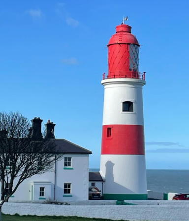
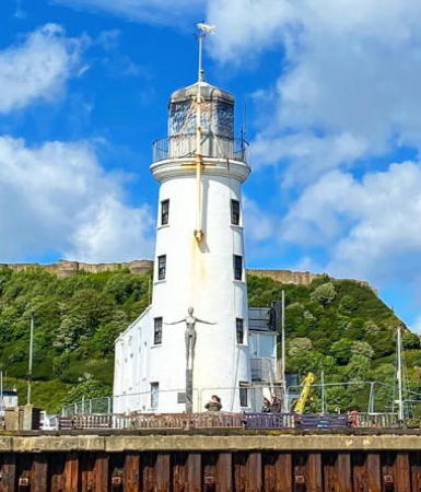
Souter Light, South Tyneside, March 2024
Instagram photo by Vicky Jeffries
Northumberland Lighthouses

Northumberland is the northernmost county of England, bordering Scotland to the north. Mostly rural, the ceremonial county has a population of about 320,000. Since 2009 Northumberland has been a unitary council area governed by the Northumberland County Council.

Berwick-Upon-Tweed Lighthouse
* Berwick-upon-Tweed Breakwater
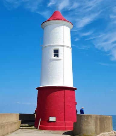
1826. Active; focal plane 15 m (49 ft); white flash every 5 s visible seaward; a continuous green light at a focal plane of 8 m (26 ft) is shown through the window on the rear of the tower. 13 m (43 ft) round stone tower with a conical stone roof; the light is displayed through a window. The roof and lowest 1/4 of the tower are painted red; the rest of the tower is painted white. David Yeaman's 2021 photo is at right, Barbara Carr has a 2013 photo, Trabas has a closeup photo, Grahame Dunbar has a 2008 photo, Christopher Tait has a 2007 photo, Wikimedia has several photos, Huelse has a historic postcard view, Marinas.com has aerial photos, Richy Hypno has a street view and Google has a satellite view. In 2011 local contractor Iain Grieve contributed his services to repaint and refurbish the lighthouse. The lighthouse was repainted again in 2020 with funds from the Harbour Commissioners and local contributions. Berwick-upon-Tweed is the northernmost town in England, right on the border of Scotland. Located at the end of the breakwater on the north side of the entrance to the River Tweed. Accessible by walking the breakwater. Site open, tower closed. Operator: Berwick Harbour Commissioners. . ARLHS ENG-173; Admiralty A2818; NGA 2264.

Holy Island Beacons
* [Lindisfarne (Emmanuel Head, Holy Island)]
Around 1800-1810. Unlit daybeacon. Approx 12 m (39 ft) square pyramidal stone tower, painted white. Rick Crowley has an excellent closeup, Darren Hall has a 2022 photo, and Google has a satellite view. Lindisfarne, properly called the Holy Island of Lindisfarne or simply Holy Island, is the site of a 7th century monastery that served as the base for Christian evangelizing in northern England during the Dark Ages. This historic daybeacon is located on Emmanuel Point at the northeast corner of the island. Accessible by hiking across the sand from the village. Site open.
Old Law (Guile Point) East
1829 (station established 1799; unlit until about 1992). Active; focal plane 9 m (29 ft); white, red, or green light, depending on direction, 4 s on 2 s off. 21 m (69 ft) square pyramidal stone obelisk; the light is mounted about 1/3 of the way up the tower. Photographers Resource has a page for the beacons, Ian Capper has a photo of both beacons, Trabas has a photo, and Google has a satellite view. This is a leading light for entrance to the harbor of Holy Island. Originally the two historic beacons formed a dayrange for the entrance. The light was established about 1992, and in 1995 Trinity House assumed responsibility for maintaining the light. Located at the tip of a long sand spit about 5 km (3 mi) northeast of Detchant. Site open, but there doesn't appear to be any road access to this site. Operator: Trinity House. ARLHS ENG-222; Admiralty A2816; NGA 2262.

Breakwater Light, Berwick-upon-Tweed , May 2021
Google Maps photo by Barbara Carr
[Old Law (Guile Point) West (2)]
1829 (station established 1799). Never lit. 25 m (82 ft) square pyramidal stone obelisk. Walter Baxter has a closeup photo, Ian Capper has a photo of both beacons, and Google has a satellite view. This is the rear beacon of the historic dayrange for the harbor of Holy Island. The original beacons were wooden towers. Located on the beach about 110 m (120 ft) west of the east beacon. Site open.

Bamburgh and North Sunderland Lighthouses
* Bamburgh (Black Rock Point) (2)
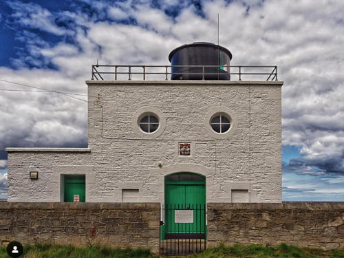
1975 (station established 1910). Active; focal plane 12 m (39 ft); white, red, or green light, depending on direction, occulting twice every 8 s. 10 m (29 ft) square building with lantern mounted on the roof. Lighthouse painted white, lantern black. No keeper's house, as this was never a staffed station. Monique Röling's 2023 photo is at right, Mark Dodds has a photo, Trabas has an excellent closeup photo by Jack Dryden, Photographers Resource has a page for the lighthouse, Rick Ford has a 2021 photo, Graham Robson has a 2013 photo, Marinas.com has aerial photos, and Google has a street view and a satellite view. The white sectors of this light guide ships around either the north or south sides of the Farne Islands. Photographer's Resource has a postcard view of the original lighthouse, a round iron skeletal tower. It was demolished in 1975 and the light moved to the roof of the original service building. Located on the rocky shore at Black Rock Point about 1.6 km (1 mi) northwest of Bamburgh. Site open, tower closed. Operator: Trinity House. . ARLHS ENG-004; Admiralty A2810; NGA 2252.
* North Sunderland (Seahouses)
1900. Active; focal plane 11 m (36 ft); continuous green light. 8 m (26 ft) hexagonal cylindrical brick tower with a domed roof, painted white; the light is shown through a window. A closeup photo is available, Trabas also has a closeup, Stephen Hamby has a photo also showing a distant view of the Inner Farne lighthouse (see below), Marinas.com has aerial photos of the harbor, and Google has a street view and a satellite view. Located at the end of the breakwater pier on the north side of the entrance to Seahouses Harbour in North Sunderland, about 20 km (12 mi) north of Alnwick. Parking is available on the pier. Site open, tower closed. Operator: North Sunderland Harbour Commissioners. ARLHS ENG-258; Admiralty A2804; NGA 2244.

Bamburgh Light, Bamburgh, March 2023
Instagram photo by Monique Röling

Farne Islands Lighthouses
The Farne Islands are a group of small islands extending perpendicular to the coast and 2.5-8 km (1.5-5 miles) offshore near Bamburgh. Famous as the refuge for St. Aiden and St. Cuthbert during the 7th century, the islands today are one of Britain's most important bird sanctuaries.
**** Longstone
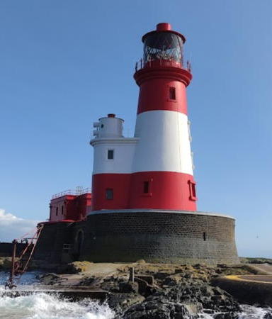
1826 (Joseph Nelson). Active; focal plane 28 m (92 ft); white flash every 20 s. 26 m (85 ft) round stone tower with lantern and gallery, painted red with a broad white horizontal band. Fog horn (2 blasts every 60 s). 1-story keeper's house. JRichard Smith's 2023 photo is at right, Photographers Resource has a page for the lighthouse, Steve Tomkins has a good closeup, Trabas has Ronald Wöhrn's view from the sea, Wikimedia has several photos, Marinas.com has aerial photos, Huelse has a historic postcard view with a 1903 inscription, Andrew Bryson has a street view, and Google has a satellite view. The lighthouse is famous for the wreck of the steamship Forfarshire in 1838; keeper William Darling and his daughter Grace heroically rescued 9 survivors of the wreck. In 2013 Trinity House considered replacing the station's diesel generator with a wind turbine; this plan was scrapped following protests. Instead, solar panels were added with the diesel as a backup. The lighthouse was closed during the 2015 season for this modernization, reopening in April 2016 with an upgraded visitor center. The lighthouse was repainted in September 2021 and Elliott John Barry's photo shows the results. Located on a tiny island at the outer end of the Farne Islands. Site of a Trinity House Visitor Centre, tower open to guided tours (reservations needed) from Seahouses (North Sunderland) daily April through October if weather and sea conditions permit. Operator: Trinity House. . ARLHS ENG-070; Admiralty A2814; NGA 2260.
Brownsman Island
1800. Inactive since 1811. Approx. 12 m (39 ft) square rubblestone tower, unroofed. A photo is available, James Furniss has a photo, and Google has a satellite view. This lighthouse replaced the earlier lights on Staple Island and was then replaced by the Inner Farne High and Low Lights. Brownsman Island is just to the north of Staple Island and about 3.2 km (2 mi) northeast of Inner Farne. Accessible only by boat. Site open, tower open but not climbable.
Staple Island (Peel Tower) (2?)
1784 (station established 1778). Inactive. Ruins, about 4 m (13 ft) high, of a square rubblestone tower. A photo is available and Google has a satellite view. According to Trinity House the first lighthouse was blown over by a storm. This is presumably the second lighthouse built on Staple and not (as Trinity Houses suggests) on Brownsman Island. Located at the southern tip of Staple Island, about 3 km (1.8 mi) northeast of Inner Farne. Accessible only by boat. Site open.

Longstone Light, Farne Islands, August 2023
Google Maps photo by Richard Smith
Inner Farne (1) (Prior Castell's Tower)
1673. Inactive since 1811. Light tower built atop a 4-story castle, now partially in ruins. Phil Champion has a photo, another photo is available, and Google has a satellite view. Inner Farne is famous as the site of an ancient monastery dating from St. Cuthbert's residence on the island in the late seventh century. The lighthouse was authorized by King Charles II. Trinity House says merchants refused to pay dues for the light and it was not lit, but there is other evidence that it was in use at least sporadically for many years and continuously starting in 1784. Located at the north end of Inner Farne. Site open, tower status unknown. ARLHS ENG-040.
Inner Farne (High) (Farne Island) (2)
1811 (Daniel Alexander). Station established 1776. Active; focal plane 27 m (89 ft); two flashes every 15 s, white or red depending on direction. 13 m (43 ft) round brick tower with lantern and gallery, painted white, attached to 1-story keeper's houses. David John Atkinson's photo is at right, Photographers Resource has a page for the station, Martin Brewster has another good photo, Trabas has a view from the sea by Ronald Wöhrn, Antonio Pistore has nice view from the sea, Marinas.com has aerial photos, and Google has a satellite view. This light guides coastwise traffic in the passage between the Farne Islands and the mainland. The former low light was demolished in 1910. In 2005 the National Trust paid £132,000 to purchase the lighthouse from Trinity House. In November 2021 Trinity House announced plans to convert the light to an LED beacon. Located on Inner Farne, the island closest to the mainland, about 3 km (2 mi) north of North Sunderland and a similar distance east of Bamburgh. Normally accessible by boat tours from Seahouses (North Sunderland), although the island was closed in 2023 due to avian flu concerns; also visible from the beach in North Sunderland or Bamburgh. Site open, tower closed. Operator: Trinity House. Owner/site manager: National Trust (Farne Islands National Nature Reserve). . ARLHS ENG-060; Admiralty A2812; NGA 2256.

Inner Farne Light, Farne Islands, September 2018
Instagram photo by David John Atkinson
 

Amble Area Lighthouses
Amble is a town of about 6000 residents adjoining the village of Warkworth a few miles southeast of Alnwick. Its port, originally developed to ship coal, now serves fishing and recreational vessels.

[Warkworth North Pier (Amble North Pier) (2)]
Date unknown (station established 1848). Active; focal plane about 20 m (66 ft); green flash every 6 s. Approx. 16 m (52 ft) steel post, painted green. David O'Rafferty has a 2022 photo and Google has an indistinct satellite view and a distant street view from the south pier. This light replaced a square skeletal tower with gallery and enclosed upper portion. Trabas has a photo of the original light and Walter Hall has a 2005 view from the south pier. Located at the end of the north pier; may be accessible by walking the pier. Site status unknown. ARLHS ENG-178; Admiralty A2785; NGA 2236.
Warkworth South Pier (Amble South Pier)
Date unknown (station established 1848). Active; focal plane 9 m (30 ft); red flash every 5 s. 8.5 m (28 ft) round cast iron post with gallery mounted on a round concrete base. Tower painted with red and white horizontal bands. A concrete catwalk leads to the lighthouse. A closeup is available, Trabas has a photo by Jack Dryden, Ray Byrne has a nice sunset photo, Wikimedia has a photo, Tim Lowrey has a street view, and Google has a satellite view. The light marks the entrance to the River Coquet at Amble; Warkworth is a town about 2.5 km (1.5 mi) upstream. Located at the end of the south pier; Lowrey's street view shows that the end of the pier has been gated to prevent close approach to the light. Site and tower closed. ARLHS ENG-179; Admiralty A2784; NGA 2232.
Coquet Island
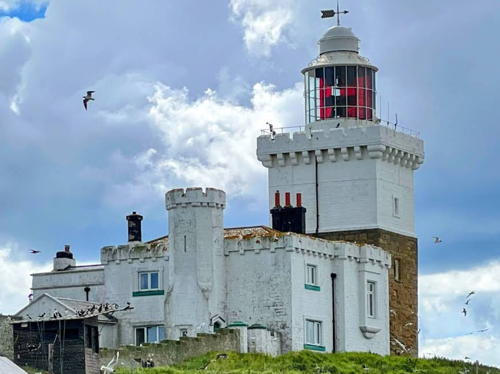
1841 (James Walker). Active; focal plane 25 m (82 ft); four flashes, red or white depending on direction, separated by 2.5 s, every 30 s. 22 m (72 ft) square cylindrical sandstone tower with lantern and castellated stone gallery, attached to a 2-story keeper's house. Lantern and upper third of tower painted white; lower 2/3 of tower is unpainted reddish-gray stone. Fog horn (blast every 30 s). A photo is at right, Trabas has a view from the sea by Jack Dryden, a 2009 closeup is available, Andrew Wilson has a 2021 view from the sea, Marinas.com has aerial photos, and Google has a satellite view. The light station is designed so that the keeper's house incorporates the surviving portion of a medieval monastery. Coquet Island is a small island, owned by the Duke of Northumberland, located about 2 km (1.2 mi) off Amble; it is an important bird sanctuary. Site (entire island) and tower closed to the public, but the lighthouse can be viewed from birding cruises from Amble. Operator: Trinity House. Site manager: Royal Society for the Protection of Birds (Coquet Island Preserve). . ARLHS ENG-025; Admiralty A2780; NGA 2228.
Coquet Island Light
Coquet Island Light, Amble
Trinity House photo

Blyth Lighthouses
Blyth is a historic city of about 40,000 residents located in the southeastern corner of Northumberland about 16 km (10 mi) north of North Shields. It has a modern and busy commercial port.
Blyth East Pier (Blyth Harbour)
1884. Active; focal plane 19 m (62 ft); four white flashes every 10 s. Fog horn (3 blasts every 30 s). 14 m (46 ft) round brick tower with lantern and gallery, painted white, mounted on a cylindrical concrete base. 3rd (?) order Fresnel lens. The lighthouse is accessed by a long catwalk. Narada Balasooriya's photo is at right, Steve Fareham has a 2007 photo, Trabas has a photo, Photographers Resource has both recent and historic photos, Huelse has a historic postcard view, Marinas.com has aerial photos, and Google has a satellite view and a distant street view from the west pier. The pier also carries a series of large wind turbines. A £20,000 project restored the exterior and repainted the lighthouse in 2016. Located at the end of the long breakwater pier at Blyth, about 20 km (13 mi) northeast of Newcastle Upon Tyne. Site and tower closed. Operator: Port of Blyth. . ARLHS ENG-013; Admiralty A2754; NGA 2180.
* [Blyth Snook Range Front]
Date unknown (the range dates from around 1900 or earlier). Active; focal plane 4.5 m (15 ft); continuous blue light. 4 m (13 ft) hexagonal wooden tower, painted white. The light is shown through a small square opening. Dan Tarbit has a closeup photo, Trabas also has a photo, and Google has a satellite view. This is the second range for the Blyth River. The rear light is on a mast. Located on the north side of the Blyth estuary opposite Low Quay. Site open, tower closed. Operator: Port of Blyth. ARLHS ENG-210; Admiralty A2770; NGA 2200.
* Blyth High (1)
1788. Inactive since 1985. 18 m (58 ft) 3-stage round brick tower, painted white. No lantern; the light was shown through a square window near the top of the tower. The tower was originally only 12.5 m (41 ft) high; its height was increased with new stages in 1888 and again in 1900. Christine Westerback has a closeup photo, a 2021 photo and another good closeup photo are available, and Google has a street view and a satellite view. The low light was on an 8 m (26 ft) hexagonal stone tower that does not seem to have survived. Located on Bath Terrace, just above the Quay in downtown Blyth. Site open, tower closed. Owner/site manager: unknown. ARLHS ENG-186.

Blyth East Pier Light, Blyth, January 2023
Google Maps photo by Narada Balasooriya
#Blyth High (Range Rear) (2)
1985. Removed about 2020. This was a 17 m (56 ft) square cylindrical skeletal tower carrying a large diamond-shaped daymark; the light is shone through a hole in the daymark. Daymark painted orange. Grant Nixon has a 2018 street view. The light was moved across the street (apparently on the same range line) between 2009 and 2013; Trabas has Arno Siering's photo of the light at the former location and Google has a 2009 street view. This was the entrance range for the River Blyth. The front light was on a similar but shorter tower. Trabas has Andreas Köhler's photo of the present directional light, shown from a post. Located at East Park View and Quay Drive in Blyth. Site open, tower closed. Operator: Port of Blyth. Admiralty A2766.1; NGA 2176.
** Trinity House Lightship 50 H.Y. Tyne III
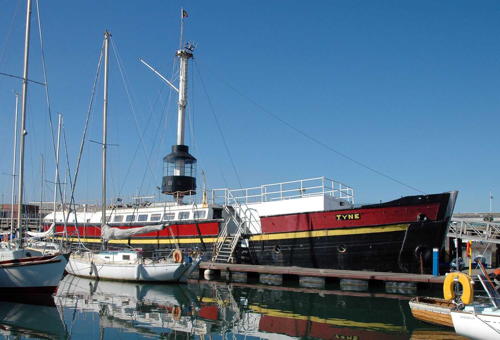
1879. Decommissioned 1950. 30.5 m (100 ft) wood lightship. A lantern on the tall mainmast is probably not the original. Ship originally painted black with a white band and white trim; recently it has been repainted with a red band along the rail above a narrow yellow band. A photo is at right, Stuart Webber has a photo, Richy Hypno has a street view, and Google has a satellite view. This was the last wooden lightship built for Trinity House. Over its long career it served numerous stations; its last assignment was as the Calshot Spit at Southampton. Since 1952 the ship has been a club ship for the Royal Northumberland Yacht Club. The Friends of LV50 organization was formed in 2014 to work for preservation and restoration of the ship. The club has a page detailing the restoration work. A plaque honoring the service of the ship was unveiled in February 2023. Moored at the club on the south side of Blyth Harbour. Site open, vessel open on the last Thursday of each month April through September and during Heritage Open Weekends in September. Owner/site manager: Royal Northumberland Yacht Club.

Lightship LV50, Blyth, 2018
photo posted by Friends of LV50

Tyne and Wear Lighthouses

The ceremonial county of Tyne and Wear was formed in 1974; as its name indicates it includes the metropolitan area surrounding the lower Rivers Tyne and Wear. Previously the North Tyneside communities were in Northumberland and the South Tyneside communities were in County Durham. The population of the county is more than 1.1 million. For local government Tyne and Wear is subdivided into two cities and three metropolitan boroughs.

North Tyneside Borough (North Shields) Lighthouses
**** St. Mary's
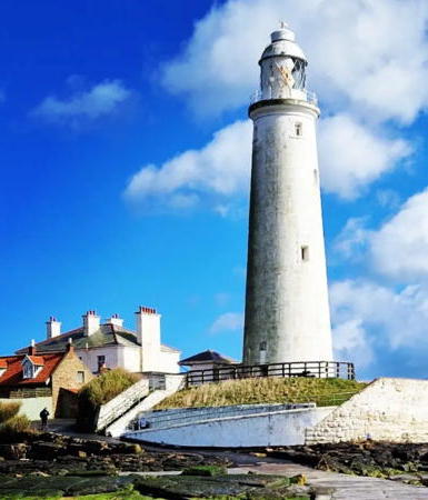
1888. Inactive since 1984. 46 m (150 ft) brick tower with lantern and gallery, painted white. The original Fresnel lens was sent to the lighthouse museum in Penzance (now closed), and the current lens was transferred from Withernsea Light (see Eastern England). A complete light station, with keeper's houses and other buildings. Max Penkethman's 2024 photo is at right, Paul Murphy's photo shows that the lighthouse is floodlit at night, Wikipedia's article has a photo by Colin Eberhardt, Photographers Resource has a page with many photos, Huelse has a historic postcard view, Marinas.com has aerial photos, and Google has a street view and a satellite view. Trinity House built this lighthouse to replace a 17th century tower at Tynemouth Castle. The light station is located on a rocky reef linked to the mainland at low tide by a walkway. After deactivation it was transferred to the local government as a tourist attraction. In July 2007 the North Tyneside Council announced £130,000 in repairs and repainting for the lighthouse. A master plan for the future of the island and light station was being prepared. The original Fresnel lens will be returned from Penzance to be displayed in the base of the tower. In May 2012 the light station was listed as a Grade II historic site. In July 2015 the North Tyneside Council announced a £2.5 million plan to restore the lighthouse and improve visitor access. In May 2016 the project received £164,300 in lottery funds for planning and engineering studies. In early 2017 the Council was seeking citizens interested in starting a lighthouse friends group. In April 2018 the Council approved a £2.1 restoration and renovation project, but the project was abandoned when funding was rejected by the Heritage Lottery Fund. In 2023 there were increasing calls for action to address the needs of the lighthouse, and North Tyneside Council agreed to fund the most needed repairs as well as new windows beginning in spring 2024. Located on a rocky point north of Whitley Bay, about 5 km (3 mi) north of North Shields. Accessible by road, parking provided. Site open; tower open to guided tours on days when the time of low tide permits (check the web site or Facebook page for a schedule) April through November and on weekends and school holidays November through March. Note: the site may be closed without notice due to bad weather or unusual tidal conditions. Owner: North Tyneside Council. Site manager: St Mary's Lighthouse and Visitor Centre . ARLHS ENG-145; ex-Admiralty A2748.
* Tynemouth (Tyne North Pier)
1903 (station established 1864(?)). Active; focal plane 26 m (85 ft; 3 white flashes every 10 s. 23 m (75 ft) round tapered stone tower with lantern and gallery, unpainted; lantern painted white. Fog horn (blast every 10 s). Janet Wales has a 2019 closeup photo, a 2007 photo is available, Trabas has Arno Siering's photo, Marinas.com has aerial photos, Sandy McArthur has a street view, and Google has a satellite view. Located at the end of the north pier at the entrance to the River Tyne in North Shields. Accessible in good weather by walking the pier. Site open, tower generally closed but open for tours during Heritage Open Days (second weekend of September). Operator: Port of Tyne. . ARLHS ENG-159; Admiralty A2700; NGA 2104.

St. Mary's Light, Whitley Bay, April 2024
Instagram photo by Max Penkethman
*** Fish Quay Old Low (Fish Quay Range Front (1))
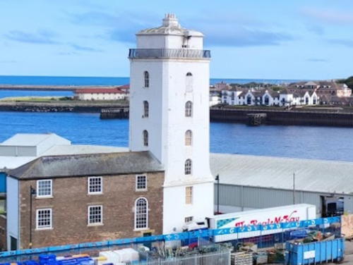
Early 1600s. Inactive since 1807. 3-story brick building. Google has a satellite view and a street view of the rear of the building. The light was apparently shown from a light tower that was removed long ago. In 1830 the deactivated lighthouse was reopened as an almshouse and the pitched roof was added at that time. In the 20th century the building was used by the Deep Sea Fisheries Association and later the Maritime Volunteer Service. Restored in 2012-14, the building now houses exhibition spaces, a café, and a gift shop; visitors can climb to a balcony for views of the harbor. Located off Union Quay in Clifford's Fort, a 17th century fortification. Site open, building open daily. Owner:North Tyneside Council. Site manager: Old Low Light Heritage Centre .
* Fish Quay Low (Fish Quay Range Front (2))
1807. Inactive since the late 1990s but recognized as a daybeacon. 26 m (85 ft) square cylindrical stone building, painted white, with a small lantern on the roof. Steven Haswell's photo is at right, Alex Perry has a good 2007 photo, David Christie has a 2018 photo, Andreas Köhler has a 2023 photo, and Google has a street view and a satellite view. This was an entrance range for the Tyne. Located on the Fish Quay on the waterfront of North Shields. Site open, tower closed. Owner/site manager: private. ARLHS ENG-300; ex-Admiralty A2703.
* Fish Quay Old Light (Fish Quay Range Rear (2))
1727. Inactive since 1807. Square brick tower with lantern, attached to a dwelling. Steve Fareham has a good 2007 photo, Jack Oliver has a 2021 photo, and Google has a street view and a satellite view. Located at the intersection of Beacon and Tyne Streets just above Fish Quay in North Shields. Site open, tower closed (private residence). Owner/site manager: private. ARLHS ENG-299.
* Fish Quay High (Range Rear)
1807. Inactive since the late 1990s but recognized as a daybeacon. 17.5 m (58 ft) square cylindrical stone building, painted white, with a small lantern on the roof, attached to neighboring building. Alex Perry has a good 2007 photo and Google has a street view and a satellite view. Located on Tyne Street behind what is now called Union Quay on the waterfront of North Shields. Site open, tower closed. Owner/site manager: private. ARLHS ENG-301; ex-Admiralty A2703.1.

Fish Quay Low Light, North Shields, August 2020
Google Maps photo by Steven Haswell

Newcastle upon Tyne City Lighthouse
* Tyne Swing Bridge
1876. Inactive. Round lantern centered on an octagonal control room atop the arched bridge. Lantern painted dark blue, control room white with a dark blue roof. An excellent photo is available, a 2008 photo is also available, Wikipedia's article has a photo, and Google has a street view and a satellite view. The Tyne Swing Bridge, designed by John Ute and built by Sir W.G. Armstrong and Company, was an engineering triumph of Victorian Britain. The bridge is still very much in use and the swing span is still operated, but the light has not been listed as an aid to navigation for many years. Many night time photos are available, but I've found none showing a light in the lantern. The bridge was restored in 2018. Located on Bridge Street in downtown Newcastle upon Tyne. Site open, tower generally closed but open for tours during Heritage Open Days (second weekend of September). Owner/site manager: Newcastle City Council. .

South Tyneside Borough (South Shields) Lighthouses
* Herd Groyne
1882. Active; focal plane 15 m (49 ft); directional light, 8 s on, 2 s off, showing white, red or green depending on direction. 15 m (49 ft) octagonal corrugated iron lantern and watch room mounted on skeletal legs. Tower painted red; lantern painted with red and white vertical stripes. Trabas has a photo by Arno Siering, Trevor Hanson has a 2022 photo, Marinas.com has aerial photos, Christopher Riddell has a street view, and Google has a satellite view. Since the late 1990s this historic lighthouse has held the leading light for the entrance to the Tyne, replacing the former range lights described above. Located at the end of the groin, off River Drive, on the south side of the Tyne in South Shields. Accessible in good weather by walking the groin. Site open, tower closed. Operator: Port of Tyne. . ARLHS ENG-330; Admiralty A2702.5; NGA Light 2112.
* Tyne South Pier (South Shields)
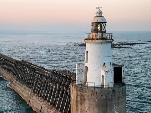
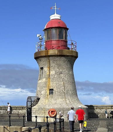
1895. Active; focal plane 15 m (49 ft); directional light, 8 s on, 2 s off, showing white over the entrance channel, red or green to the sides. 12 m (39 ft) round tapered stone tower with lantern and gallery, unpainted; lantern painted white. Fog bell (stroke every 10 s). A photo is at right, Trabas also has an excellent photo by Arno Siering, Konstantin Stoyanov has a 2019 closeup, Philippa Tooms has a 2021 photo, Marinas.com has aerial photos, Alan Rodmell has a street view, and Google has a satellite view. In October 2023 Storm Babet blew off the dome of the lantern. Located at the end of the mile-long south pier at the entrance to the River Tyne in South Shields. Accessible in good weather by walking the pier. Site open, tower closed. Operator: Port of Tyne. ARLHS ENG-158; Admiralty A2702; NGA Light 2108.

Tyne South Pier Light, South Tyneside, June 2018
Wikimedia Creative Commons photo by Chabe01
**** Souter (Marsden Head)
1871. Inactive since 1989. 23.5 m (77 ft) brick tower with lantern and gallery, attached to keeper's house. Lighthouse painted with red and white horizontal bands. Rare "biform" 1st order Fresnel lens (two sets of prisms, one atop the other), installed in 1915. The keeper's quarters house a museum, tea room, and gift shop. Original fog signal building; the working diaphone fog horns are operated on special occasions. Vicky Jeffries's photo is at the top of this page, Photographers Resource has a good page for the lighthouse with many photos, Paul Featherstone has a nice 2008 photo, Wikimedia has an excellent photo by Glenn Scott, Huelse has a historic postcard view, and Google has a street view and a satellite view. This is an unusually complete and well preserved light station; now operated by the National Trust, it is one of the most visited lighthouses of England. The exterior of the lighthouse was restored and repainted in a £65,000 project in the fall of 2013 and the lantern was restored by a £120,000 project in the fall of 2015. Two keeper's apartments are available for overnight accommodations. The station has well-tended gardens as well as a picnic area. The Whitburn Coastal Conservation Centre opened next to the lighthouse in January 2024. Located adjacent to the Whitburn Coastal Park, off the coastal road (A183) in Whitburn about 5 km (3 mi) north of Sunderland. Parking provided. Site open; tower open to guided tours daily February through November. Owner/site manager: National Trust (Souter Lighthouse and the Leas) . ARLHS ENG-127; ex-Admiralty A2694.

Sunderland City Lighthouses
Sunderland is a city of about 175,000 residents at the mouth of the River Wear about 15 km (9 mi) south of the Tyne.

* Sunderland Old South Pier (Seaburn) (relocated)
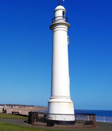
1856 (Thomas Meik). Inactive since 1903. 15 m (50 ft) round cast iron tower with lantern and gallery, painted white. Laurence Hill's photo is at right, Steve Fareham has a good 2007 photo, Michelle Simmons has a good photo, Mel Thirtle has a 2021 photo, and Google has a street view and a satellite view. When the South Pier was shortened in 1983 the lighthouse was relocated to a site overlooking the sea in Roker Cliffe Park. In October 2015 the lighthouse was listed as "At Risk" by Historic England. The city commissioned an engineering study and allocated funds for restoration; the work was carried out in late summer and fall 2016. Located in Roker Cliff Park, off Whitburn Road at the foot of Chichester Road in Seaburn, on the north side of Sunderland. Limited on-street parking nearby. Site open, tower closed. Owner/site manager: City of Sunderland. ARLHS ENG-117.

South Pier Light, Sunderland, March 2022
Google Maps photo by Laurence Hill
*** Roker Pier (Sunderland North Pier)
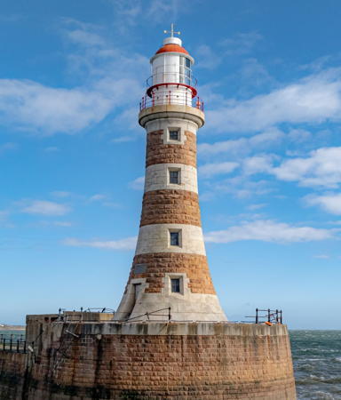
1903. Active; focal plane 25 m (82 ft); white flash every 5 s. 23 m (75 ft) round tapered granite tower with red and white horizontal bands, lantern and gallery. Tower unpainted; the bands are formed of natural red and white colored granite. Lantern painted white with a black dome. Fog signal (siren blast every 20 s). A 2024 photo is at right, John Kirkwood has a good photo, Saman Momeni has a 2022 photo, Photographers Resource has a page with photos, Trabas has a closeup, Wikipedia has the history of the lighthouse, Marinas.com has aerial photos, Uy Hoang has a street view, and Google has a satellite view and a distant street view across the harbor. Designed by Henry Hay Wake, the Roker Pier was a major project of Victorian Britain during its construction from 1885 to 1895. The pier is 610 m (2000 ft) long. A tunnel runs through its entire length to provide protected access to the lighthouse, which was described originally as Britain's most powerful port lighthouse. In 2013 the city began a major project to restore both the pier and the lighthouse. In 2014 the pier was resurfaced and restored and the lantern room of the lighthouse was replaced. In March 2015 city council allocated £136,000 to restore the light tower. Following completion of the restoration, the pier and lighthouse opened for tours on a regular basis in August 2018. Located at the end of the pier on the north side of the entrance to the River Wear in Sunderland. Normally accessible by walking the pier. Site, pier and tower open for tours weather permitting (reservations required). Operator: Port of Sunderland. Site manager: Roker Pier and Lighthouse . ARLHS ENG-116; Admiralty A2681; NGA 2084.
Sunderland Tidal Basin Entrance
Date unknown. Active; focal plane about 18 m (59 ft); red flash every 2.5 s. Approx. 15 m (49 ft) octagonal cylindrical tower rising from a 1-story building. Building and tower painted a light brown, lantern black. Trabas has a photo, Andreas Köhler has a 2023 photo, Uy Hoang has a street view across the harbor, and Google has a satellite view. Located on a quay on the south side of the River Wear harbor. Site and tower closed. Operator: Port of Sunderland. Admiralty A2691.
#Roker New South Pier (1)
Date unknown. Replaced around 2022. This was a 10 m (33 ft) round cylindrical metal tower painted white. No photo available. The original plan was to build a twin of the north pier lighthouse on the south pier, but these plans were abandoned during World War I. Trabas has Andreas Köhler's 2023 photo of the active light (focal plane 14 m (46 ft); white flash every 10 s), now on a simple post, and Google has a satellite view. Located at the end of the pier on the south side of the entrance to the River Wear. Site status unknown. Operator: Port of Sunderland. Site and tower closed. ARLHS ENG-117. Active light: Admiralty A2682; NGA 2080.

Roker Pier Light, Sunderland, April 2024
Instagram photo by Peace Drone

County Durham Lighthouses

Historically County Durham included the land between the Tyne and Tees estuaries, but the ceremonial county is reduced in size. The modern county has a population of around 870,000. The Durham County Council administers most of the ceremonial county but there are three independent boroughs including the Borough of Hartlepool in the southeast.

Seaham Lighthouse
Seaham North Breakwater
1905. Active; focal plane 12 m (39 ft); long (1.2 s) green flash every 10 s; continuous green shown in bad weather. 10 m (33 ft) round cast iron tower with lantern, painted with black and white horizontal bands. The gallery was removed sometime in recent years. Fog horn (blast every 30 s). Trevor Hanson has a 2023 photo, Gem Fox has a 2008 photo, Trabas has a photo, Wikimedia has a good photo, Marinas.com has aerial photos, Paul Webzell has a distant street view, and Google has a satellite view. Seaham is a town in the Durham County Council area. Located at the end of the north breakwater in Seaham. Site, pier and tower closed. Operator: Seaham Harbour Authority. . ARLHS ENG-123; Admiralty A2674; NGA 2072.

Hartlepool Borough Lighthouses
* The Heugh (Hartlepool Headland) (3)
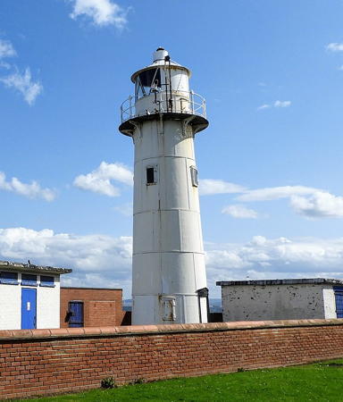
1927 (station established 1847). Active; focal plane 19 m (62 ft); two white flashes every 10 s, day and night. 16.5 m (54 ft) round steel tower with lantern and gallery, painted white. A photo is at right, Martin Brewster has another fine closeup photo, a third good closeup is available, Trabas has a photo by Capt. Peter Mosselberger, and Google has a street view and a satellite view. The original lighthouse, a 14.5 m (46 ft) tapered sandstone tower, was the first British lighthouse designed to be fueled entirely by natural gas from nearby coal mines. This lighthouse, seen in a historic postcard view posted by Huelse, was undamaged by shelling from German ships in early 1915, but it was demolished later that year because it stood in the line of fire of coastal artillery. The lantern and lens were mounted on a temporary square pyramidal frame tower with enclosed watch room, located on the Town Moor behind the guns. The lantern and lens are now on display at the Hartlepool Museum on Maritime Avenue. Located at Moor Terrace and Bath Terrace on the headland known as the Heugh (pronounced "uff"), sheltering Hartlepool Harbour, on the north side of the city. Limited parking available. Site open, tower closed. Operator: PD Teesport. . ARLHS ENG-314; Admiralty A2663; NGA 2056.
* Hartlepool Old Pier (Pilots Pier)
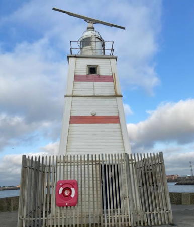
1836. Active; focal plane 13 m (43 ft); flash every 3 s, white over the entrance channel and green otherwise. 12 m (39 ft) square pyramidal wood tower, painted white with two narrow horizontal red bands on each face. Rotating radar antenna atop the lantern. Trabas has a fine closeup, another good closeup photo is available, Wikimedia has Ian Paterson's photo, Marinas.com has aerial photos, Peter Greig has a closeup street view, and Google has a more distant street view and a satellite view. Recently renovated by the port authority, the Old Pier is now called Pilots Pier. Located at the end of the pier on the north side of the entrance to the old harbor at Hartlepool. Accessible by walking the pier. Site open tower closed. Operator: PD Teesport. ARLHS ENG-305; Admiralty A2664; NGA 2052.
* Hartlepool Victoria Harbour (Leading Light)
Date unknown. Active; focal plane 42 m (138 ft); white, red or green light, depending on direction, 1.5 s on, 1,5 s off. 40 m (131 ft) square skeletal tower. Trabas has a photo by Capt. Peter Mosselberger and Google has a street view and a satellite view. Located at the head of the harbor basin in Hartlepool. Site and tower closed (restricted area). Admiralty A2666; NGA 2057.

The Heugh Light, Hartlepool, August 2019
Wikimedia Creative Commons photo by Reading Tom
* Hartlepool West Harbour
Date unknown. Active; focal plane 6 m (20 ft); flash every 2 s, white, red or green depending on direction. Light mounted on the balcony railing of a 2-story concrete block harbor master's office. Trabas has a good photo, and Google has a street view and a satellite view. Located on the north side of the sea lock at the entrance to the Hartlepool West Harbor, used by small craft. Site and building open. Operator: PD Teesport. Admiralty A2667.4; NGA 2062.
* Seaton Carew High (Seaton Tower) (relocated to Hartlepool)
1839. Inactive since the 1890s. Approx. 19 m (62 ft) round stone tower on a square stone base; lantern removed. The tower is unpainted. The lighthouse formerly stood at Seaton Carew southeast of Hartlepool. It was taken down and rebuilt as a memorial to sailors lost at sea during the redevelopment of the Hartlepool waterfront. Stephen Webster has a photo, William Hall has a 2022 closeup, Wikimedia has Hermann Luyken's view from the harbor, and Google has a street view and a satellite view. Located at the end of a pier inside the Hartlepool Marina in downtown Hartlepool. Site open, tower closed. Site manager: unknown. ARLHS ENG-332.

North Yorkshire Lighthouses

North Yorkshire is the largest of England's ceremonial counties, with a total population approaching 1.2 million. Formerly it was divided into eleven council areas, three of them along the coast. Of those three the Middlesbrough Borough and Redcar and Cleveland Borough continue as unitary council areas. In April 2023 the former Scarborough Borough and six other districts were merged into a new North Yorkshire District that covers most of the county.

Middlesbrough Borough Lighthouses
River Tees Range Front (2)
Date unknown. Active; focal plane 18 m (59 ft); continuous red light. Approx. 14 m (46 ft) round cylindrical tower colored with red and white horizontal bands. Trabas has a photo by Capt. Theo Hinrichs and Google has a satellite view and a distant street view. NGA lists framework towers for these range lights. Located on the waterfront opposite the entrance to the Tees estuary. Site and tower closed (industrial area). Operator: PD Teesport. Admiralty A2627; NGA 2024.
River Tees Range Rear (2)
Date unknown. Active; focal plane 20 m (66 ft)); continuous red light. The light is mounted partway up a tall triangular skeletal tower. The tower carries a rectangular daymark colored with red and white horizontal bands. Trabas has a photo and Google has a satellite view. Located 560 m (0.35 mi) southwest of the front light. Site and tower closed (industrial area). Operator: PD Teesport. Admiralty A2627.1; NGA 2028.

Redcar and Cleveland Borough Lighthouses
South Gare
1884. Active; focal plane 16 m (53 ft); long (1.5 s) flash, white or red depending on direction, every 12 s. 13 m (43 ft) round cylindrical cast iron tower with lantern and gallery. Entire lighthouse painted white. Fog horn (two blasts every 30 s). Yvonne Roberts has a good photo, Trabas has a photo, Mally Mclane has a street view, and Google has a satellite view. In 2007 the lighthouse became the first in the U.K. to be powered by a hydrogen fuel cell. Located at the end of the stone pier at the entrance to the River Tees about 8 km (5 mi) northwest of Redcar. Site and tower closed (pier fenced). Operator: PD Teesport. ARLHS ENG-131; Admiralty A2626; NGA 2020.

South Gare Light, South Tyneside, August 2021
Google Maps photo by Paul Waugh
* Redcar Promenade Range Rear (?)
Date unknown. Active; focal plane 11 m (36 ft); red light, 1.5 s on, 1 s off. Light mounted near the top of a 2-story red brick building. Trabas has a photo and Google has a 2023 street view and a satellite view. The building is a former Marks and Spencer grocery. In September 2021 the Redcar and Cleveland Council purchased the building with the intention of demolishing it in order to create a park linking downtown to the seafront. Located on the Esplanade in Redcar. The front light is on a pole across the street. Site open. Admiralty A2620.1; NGA 2012.

Former Scarborough District Lighthouses
* Whitby West Pier (2)
About 1914 (station established 1831). Active; focal plane 14 m (46 ft); continuous green light. 7 m (23 ft) round wood lantern mounted on a square wood skeletal tower. Lantern painted green; the wood legs are unpainted. Trabas has a photo, Wikimedia has Nicholas Mutton's closeup, and Google has a satellite view and a street view showing all four pier lights. Located at the end of the extended Whitby West Pier. Accessible by walking the pier. Site open, tower closed. Operator: Whitby Harbour. Admiralty A2599; NGA 1984.
* Whitby West Pier (1)
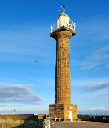
1831. Generally inactive since about 1914; a green light is displayed when a vessel is expected and it is safe to enter the harbor. 25 m (83 ft) round cylindrical fluted stone tower with lantern and gallery, mounted on a square base. Tower unpainted, lantern painted white with a black dome. Jake Hannath's 2021 photo is at right, another photo is available, Trabas has a photo, Marinas.com has aerial photos, and Google has a street view and a satellite view. The Whitby piers were extended in 1914 and the active lights were moved to wood skeletal towers at the ends of the extensions. Formerly open for climbing, the lighthouse was closed in February 2012 due to structural concerns. It was estimated that £200,000 would be needed to repair the two 19th century pier lighthouses and even more expensive repairs would be needed for the piers themselves. The pier restoration, estimated to cost £8.6 million, was scheduled for 2017-18. In late 2015 the Coastal Revival Fund granted £90,000 for restoration of the west pier lighthouse. Work began in February 2016 and was to be completed in May. However by 2024 the lighthouse was reported in poor condition and barriers were placed around it. The North Yorkshire Council approved £252,000 to plan a major restoration estimated to cost about £3.2 million. Located at the original end of the west pier; accessible by walking the pier. Site open, tower closed. Owner/site manager: North Yorkshire Council. . ARLHS ENG-165; Admiralty A2599.2.

1831 West Pier Light, Whitby, April 2021
Instagram photo
by Jake Hannath
 
* Whitby East Pier (1)
1855. Inactive since about 1914. 17 m (55 ft) round cylindrical stone tower with lantern and gallery, mounted on a square base. Tower unpainted, lantern painted white with a black dome. Hanan Smart has a fine closeup, Trabas has a photo, Karl Kilner has a 2019 photo, another photo is available, Marinas.com has aerial photos, and Google has a street view and a satellite view. The Whitby piers were extended in 1914, and the active lights were moved to wood skeletal towers at the ends of the extensions. Located at the original end of the east pier; accessible by walking the pier. Site open, tower closed. Owner/site manager: North Yorkshire Council. ARLHS ENG-163.
Whitby East Pier (2)
About 1914 (station established 1855). Active; focal plane 14 m (46 ft); continuous red light. 7 m (23 ft) round wood lantern mounted on a square wood skeletal tower. Lantern painted red; the wood legs are unpainted. Jon Tait has a photo, Paul Bradley has a 2008 photo, Trabas has a closeup, Marinas.com has aerial photos, and Google has a satellite view. Located at the end of the extended Whitby East Pier, which is detached from the older pier. Site and tower closed. Operator: Whitby Harbour. Admiralty A2598; NGA 1988.
* Whitby High
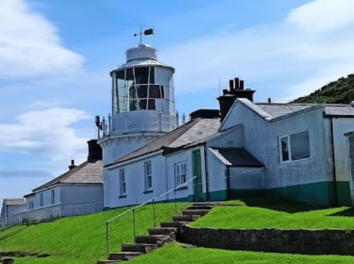
1858 (James Walker). Active; focal plane 73 m (240 ft); white or red light, depending on direction, 5 s on 5 s off. 13 m (43 ft) octagonal brick tower with lantern and gallery, painted white, attached to 1-story keeper's house. Gary Fisher's photo is at right, there's a similar 2009 photo by Martin Dawes, another good photo is available, Trabas has a photo, Wikimedia has Phil Catterall's closeup photo, Photographers Resource has a page with several photos, Marinas.com has aerial photos, Jon Bulmer has a street view, and Google has a satellite view. Two keeper's cottages are available for overnight accommodations. The original low lighthouse was deactivated in 1890 and subsequently demolished. Located atop a cliff about 3 km (2 mi) east of Whitby Harbour. Site open, tower closed. Operator: Trinity House. . ARLHS ENG-164; Admiralty A2596; NGA 1992.

Whitby High Light, Whitby, June 2020
Google Maps photo
by Gary Fisher
* Scarborough Pier (St. Vincents Pier) (2)
1931 (reconstructed 1806 lighthouse; inactive 1914-1931). Active; focal plane 17 m (56 ft); white light, 2.5 s on, 2.5 s off. 15 m (49 ft) round brick tower with lantern and gallery, painted white, attached to 2-story keeper's house (1843). Fog horn (blast every 60 s). A 2022 photo is at right, P. Astbury has a 2015 photo, a winter 2008 photo and a good 2007 photo are available, Trabas has a closeup, Huelse has a historic postcard view, Marinas.com has aerial photos, and Google has a street view and a satellite view. The tower was heightened by 5 m (17 ft) in the 1840s. The original lighthouse had to be demolished after being heavily damaged by shelling from a German ship in 1914; the current tower was built to replace it in 1931. The keeper's house has been used as an office and clubhouse by the Scarborough Yacht Club since 1952. The exterior of the lighthouse was repaired and restored in 2008. In 2024 there were fears of possible collapse of the pier under the building and the area was closed to the public. North Yorkshire Council approved £795,000 to plan a major restoration estimated to cost about £7.7 million. Located on a pier in the old harbor at Scarborough; the pier's original name is St. Vincent's Pier but it is usually called Lighthouse Pier. Accessible by walking the short pier. Site open, tower closed. Owner/operator: North Yorkshire Council. Site manager: Scarborough Yacht Club. . ARLHS ENG-121; Admiralty A2592; NGA 1976.
 

Information available on lost lighthouses:

  • Blyth West Pier (1888-?), Blyth, Northumberland. Photographers Resource has a historic photo (halfway down the page). The pier is now marked by two red lights on a mast; Trabas has a photo. Admiralty A2760; NGA 2184.
  • Farne Island North (1811-1910), Farne Island, Northumberland. Trinity House mentions this 8 m (27 ft) stone lighthouse on its Farne Island page. It was located on the northwest point of the island.
  • Red Acre Point (1831?-1940), Seaham, Durham. This 18 m (58 ft) stone lighthouse was deactivated in 1905 and demolished in 1940 to prevent it from guiding German ships in World War II. There is a viewing platform on the point today; Google has a satellite view of the location.
  • Seaton Carew Low (1839-1902?), Hartlepool, Durham. Demolished; the location may have been lost to beach erosion.
  • Sunderland Old North Pier (1) (1802-1920?), Sunderland, Tyne and Wear. A historic photo is available. The pier is now marked by a light on a tall mast; Trabas has a photo and Google has a satellite view of the pier. Admiralty A2686; NGA 2092.
  • Tynemouth Castle (1681-1898), North Tyneside, Tyne and Wear. This historic lighthouse was demolished in 1898-99. Google has a satellite view of the ruins of the castle.

St. Vincents Pier Light, Scarborough, July 2022
Instagram photo
by v_schollar

Notable faux lighthouses:

Adjoining pages: North: Southeastern Scotland | South: Eastern England

Return to the Lighthouse Directory index | Ratings key

Posted August 27, 2004; checked and revised April 25, 2024. Lighthouses: 46; lightships: 1. Site copyright 2024 Russ Rowlett and the University of North Carolina at Chapel Hill.