Lighthouses of the United Kingdom: Southeastern Scotland

The United Kingdom (officially the United Kingdom of Great Britain and Northern Ireland) includes England, Scotland, Wales, and Northern Ireland. Occupying the northern third of the island of Great Britain, the kingdom of Scotland has shared its monarch with England since 1603 and has been part of the United Kingdom since 1707. The coastline of the country is deeply cut by inlets, and there are more than 790 islands. The country has a long and distingushed maritime history; many of the most famous British captains and navigators have been Scots.

Scotland was divided historically into 34 counties; the counties no longer have any administrative function although they continue to have cultural significance. Since 1996 the country has been divided into 32 council areas for the purposes of local government. This page is for lighthouses in the southeastern corner of Scotland surrounding the Firth of Forth and its approaches, including the city of the Edinburgh and the council areas of Fife, Falkirk, West Lothian, East Lothian, and Scottish Borders.

The Scottish word loch is used both for lakes and for inlets of the sea; a firth is a larger bay or strait, a ness is a cape, and a mull is a rounded headland. The Scottish Gaelic phrase for a lighthouse is taigh solais; eilean is an island, sgeir is a skerry or rock, and rubha or àird is a cape or promontory.

The Northern Lighthouse Board, established by an act of Parliament in 1786, manages the major lighthouses of Scotland and the Isle of Man. For five generations engineers of the Stevenson family created for the Board a network of elegant and durable lighthouses famous around the world. Most of these lighthouses remain in service today.

ARLHS numbers are from the ARLHS World List of Lights. Admiralty numbers are from Volume A of the Admiralty List of Lights & Fog Signals. U.S. NGA numbers are from Publication 114.

General Sources
Northern Lighthouse Board - Lighthouse Library
The Board's web site includes information and photos for many of the lighthouses.
Michael's List of Scottish Lighthouses
A comprehensive web site by Michael Spencer. A draft of Section A covers the region south of the Firth of Forth.
Lighthouse Archives
Lighthouse information from LighthouseAccommondations.uk.
Lighthouses on the East Coast of Scotland
Photos and information for the major lighthouses, posted by Bob Schrage.
Online List of Lights - Scotland
Photos of Scottish aids to navigation posted by Alexander Trabas.
Lighthouses in Scotland
Photos available from Wikimedia; many of these photos were first posted on Geograph.org.uk.
World of Lighthouses - Scotland
Photos by various photographers available from Lightphotos.net.
United Kingdom Lighthouses
Aerial photos posted by Marinas.com.
 
Fife Harbor Lights
Rare photos contributed to the Directory by Michael Spencer.
The Stevensons
The history of Scotland's remarkable family of lighthouse engineers.
Britische Leuchttürme auf historischen Postkarten
Historic postcard images posted by Klaus Huelse.
GPSNavigationCharts
Navigation chart for this area.
Navionics Charts
Navigation chart for this area.

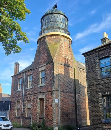
Barns Ness Light
Barns Ness Light, East Lothian, May 2010
Geograph Creative Commons photo by Richard West

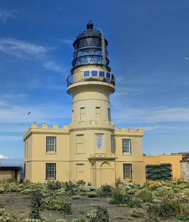
Isle of May High Light
Isle of May High Light, Fife, June 2004
Geograph Creative Commons photo by Norrie Adamson

Fife Lighthouses

Fife is a council area and historic county occupying the peninsula between the Firth of Tay on the north and the Firth of Forth on the south.

Tayport Lighthouses
The Firth of Tay is the traditional border between Fife and Angus. The principal port on the Tay is Dundee, on the north shore in Angus. Tayport, formerly known as Ferry-Port-on-Craig, is a former fishing and ferry port downstream from Dundee on the south bank. The Tay Road Bridge put the ferries out of business in 1966 and the town's historic harbor now serves mostly recreational craft.

[Newport-on-Tay]
Date unknown. Inactive since 1966. Approx. 3 m (10 ft) iron post carrying an octagonal lantern. Beacon painted white. Brian Cargill has contributed a photo and Google has a street view, but the tiny light is barely visible in Google's satellite view. Endangered: this small but historic beacon deserves recognition and preservation. Located on the old ferry pier at Newport-on-Tay, upstream from Tayport and directly across the River Tay from Dundee. Site status unknown.
* Tayport High (Tayport West)
1820. Active; focal plane 24 m (79 ft); directional light, 1.5 s on, 1.5 s off: showing white over the clear channel, red or green to the sides. 23 m (76 ft) round stone tower with lantern and gallery, painted white. The active light appears to be on a short mast atop the lantern. Richard Webb's photo is at right, Trabas has a photo, a good closeup is available, Scott Marshall has a 2019 photo, Huelse has a historic postcard view, Marinas.com has aerial photos, and Google has a satellite view and a distant street view. The lighthouse is usually called the "Western Lighthouse" in Tayport. Its leading light guides vessels entering the estuary. The 1-story keeper's house was sold in 2003 to David Nicholls, who began restoring the property. In 2007, unfortunately, Nicholls died suddenly. The property was then sold to David Norman and his wife, who are continuing the renovation. All three Tayport lighthouses were built by the harbor board of the city of Dundee. Located at the edge of the Firth of Tay in Tayport, about 200 m (700 ft) west of the old low light. Both low and high lighthouses are on the town's Lighthouse Walk, beginning at a carpark on Commonty Road. Site open, tower closed. Operator: Forth Ports PLC. Site manager: private. . ARLHS SCO-237; Admiralty A3142; NGA 2620.
* Tayport Low (Tayport East)
1823. Inactive since 1848. Approx. 12 m (39 ft) round stone tower with lantern and gallery. Tower unpainted, lantern painted white. Ian Macdonald has a good closeup photo, David Leigh Smith has a 2022 photo, Marinas.com has aerial photos, Huelse has a historic postcard view, and Google has a satellite view. The lighthouse, usually called the "Eastern Lighthouse" in Tayport, was replaced by the pile lighthouse (next entry). Both low and high lighthouses are on the town's Lighthouse Walk, beginning at a carpark on Commonty Road. Located at the edge of the Firth of Tay in Tayport. Site and tower closed, but the lighthouse can be seen from nearby. Owner/site manager: private. . ARLHS SCO-290.
Tayport High Light
Tayport High Light, Tayport, February 2012
Geograph Creative Commons photo by Richard Webb
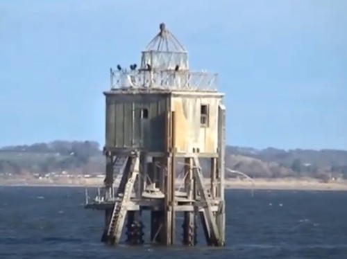
Tayport Pile (Larick Scalp, Larick Beacon)
1845. Inactive since about 1960; charted as a daybeacon. 16 m (52 ft) tower, with a lantern atop an octagonal wood keeper's quarters, mounted on wood pilings. A 2022 photo is at right, Bob Shand has a good photo, Marinas.com has aerial photos, and Google has a satellite view and a distant street view. Endangered. This is one of only a few surviving pile lighthouses in the U.K. It was built when the 1823 low lighthouse (previous entry) was judged to be too close to the high light. Most lighthouse sources have 1845 as its construction date, but the British Listed Buildings index has it built in "1848 probably by James Leslie." Located about 500 meters (1/3 mile) northeast of the Tayport waterfront on the south side of the Firth of Tay. Accessible only by boat. Site and tower closed. Owner/site manager: unknown. ARLHS SCO-289.

St. Andrews Lighthouses
St. Andrews is a historic town on the east coast of Fife. It is famous for the ruins of its 12th century cathedral, for its university (the oldest in Scotland), and for the Royal and Ancient Golf Club of St. Andrews, celebrated as the "home of golf" for its role in popularizing and managing the sport since the late 1700s.

*
St. Andrews (Range Rear)
1849. Inactive for many years. Approx. 15 m (49 ft) round cylindrical stone tower. This tower is connected by a wall to the east towers--the largest surviving remnants--of the 12th century St. Andrews Cathedral. The tower that was used as a lighthouse is at the left in a photo of the cathedral ruins, a similar photo is available, and Google has a street view and a satellite view. The front light of the range was on the town pier. Site open, tower closed.
* St. Andrews
Date unknown. Active; focal plane 17 m (56 ft); white, red or green light, depending on direction, 1 s on, 1 s off. Approx. 5 m (17 ft) semicircular stone watchtower. Trabas has a photo and Google has a street view and a satellite view. This leading light guides small craft into the harbor of St. Andrews. Located on the east side of the cathedral ruins, above the harbor. Site open, tower closed. Admiralty A3104.5; NGA 2614.

Tayport Pile Light, Tayport, April 2022
Google Maps photo by mcdermc

East Neuk and Isle of May (Lower Firth of Forth Northside) Lighthouses
The East Neuk is a section of coast facing southeast on the north side of the entrance to the Firth of Forth. There is a series of small villages along this coast, Anstruther being the largest.

[North Carr Beacon]
1821 (Robert Stevenson). Unlit daybeacon. 12 m (40 ft) hexagonal pyramidal cast iron skeletal tower topped by a ball daymark, mounted on a round stone base. Wikimedia has Kathrin Passig's photo but the beacon is not seen in Google's satellite view. The North Carr Rocks extend dangerously 2.5 km (1.5 mi) northeast from Fife Ness. They are too fragmented to support a lighthouse, and it took 8 years of effort to place a beacon on the outer rocks. The lightship North Carr, formerly stationed off the rocks, awaits restoration in Dundee (see the Eastern Scotland page). The lightship was replaced by a buoy. Accessible only by boat. Site open, tower closed.
Fife Ness
1975. Active; focal plane 12 m (39 ft); white or red light, depending on direction, 5 s on, 5 s off. 5 m (16 ft) lantern room attached to a 1-story concrete equipment building. Coast Guard station nearby. Robert Smallman's photo is at right, Lighthouse Accommodations has a page for the lighthouse, Schrage also has a good page, Anne Burgess has a 2008 photo, Trabas has a good photo, Mimi Chan has a 2021 photo, and Google has a satellite view. The lighthouse replaced a lightship station off the cape. The well known golf links of the Crail Golfing Society surround the light station. Located at the easternmost point of Fife, marking the north side of the entrance to the Firth of Forth. Site open only with permission of the golf club, tower closed. Operator: Northern Lighthouse Board. . ARLHS SCO-081; Admiralty A3102; NGA 2612.
Fife Ness Light
Fife Ness Light, Craighead, July 2008
Geograph Creative Commons photo by Robert Smallman
[Isle of May North Fog Signal]
Inactive since 1989. Approx. 9 m (30 ft) round stone tower painted white and carrying a large diaphone fog horn. Google has a satellite view. Located on Rona, a northern section of the Isle of May separated from the main section by a narrow cleft in the rock. A footbridge formerly crossed the gap, but it was removed to discourage visitors from disturbing nesting seabirds. Site and tower closed.
* Isle of May Low
1844. Inactive since 1887. Approx. 12 m (40 ft) round cylindrical stone tower with lantern and gallery attached to a 1-story keeper's house. Tower painted white; lantern dome is black. Chris Golightly's photo is at right, Lighthouse Accommodations has a good page for the island's lighthouses, Schrage also has a page, Shahbaz Majeed has a good photo, Allison Stamp has a closeup, Marinas.com has aerial photos, Huelse has a historic postcard view, and Google has a satellite view. The keeper's house now houses the Isle of May Bird Observatory. The range guided ships around the notorious North Carr Rock; the low light was deactivated when the North Carr lightship station was established in 1887. The rocky Isle of May, located about 8 km (5 mi) east of Anstruther in the northern entrance to the Firth of Forth, is a bird and seal sanctuary, the Isle of May National Nature Reserve. Located at the easternmost point of the island. Accessible only by boat; tours are available from Anstruther, and in 2005 a passenger ferry from North Berwick was established. Site open, tower closed. Owner/site manager: Scottish Natural Heritage. . ARLHS SCO-109.
* Isle of May (1) (Isle of May Beacon)
1636 (Alexander Cunningham). Inactive since 1816. 12 m (40 ft) square castellated stone tower, painted white. Lighthouse Accommodations has a closeup photo (second photo on the page), this building is to the left of the high lighthouse in this photo and Google has a satellite view. Open coal fires were displayed from this tower, generally recognized as Scotland's oldest lighthouse. There was a disaster here in 1791, when the keeper, his wife, and five of their six children all died of carbon monoxide poisoning while asleep in the building. The building was restored in 2021; Schrage's page has a photo of the results. Located near the present lighthouse (next entry). Site open, tower closed except during special events. ARLHS SCO-108.

Isle of May Low Light, Firth of Forth, June 2013
Flickr Creative Commons photo by Chris Golightly
**** Isle of May (High) (2)
1816 (substantially altered in 1886) (Robert Stevenson). Station established 1635. Active; focal plane 73 m (240 ft); two white flashes every 15 s. 24 m (79 ft) square cylindrical stone tower with lantern and gallery, rising from a 2-story stone keeper's house. Building unpainted, lantern painted black. Norrie Adamson's photo is at the top of this page, Lighthouse Accommodations has a good page for the island's lighthouses, Schrage also has a page, Magdalen Green has a good photo, Trabas has a fine photo, Wojciech Suszko has a 2023 photo, Huelse has a historic postcard view, Marinas.com has aerial photos, and Google has a good satellite view. The lighthouse has been beautifully restored; the interior has a carpeted stairway and a boardroom for visiting commissioners. Located at the highest point of the island. Accessible only by boat; tours are available from Anstruther. Site open, tower open for tours daily during the summer season. Operator: Northern Lighthouse Board. Site manager: Scottish Natural Heritage (Isle of May National Nature Reserve). . ARLHS SCO-286; Admiralty A3090; NGA 2600.
* [Isle of May South Fog Signal]
Inactive since 1989. Approx. 9 m (30 ft) round stone tower painted white and carrying a large diaphone fog horn. Lighthouse Accommodations has a photo and historical information (bottom of the page), James Stringer has a photo and Google has a satellite view. The south signal is at the southern tip of the Isle of May. Site and building open for tours daily during the summer season.
* [Crail Range Front]
Date unknown. Active; focal plane 24 m (79 ft); continuous red light. 6 m (20 ft) solid stone tower painted white. Trabas has a photo, Terry Gilley has a closeup photo, and Google has a street view and a satellite view. The Crail beacons are listed as lighted on Findlay's 1879 list; probably they are much older daybeacons to which lights were attached. Located just below Anstruther Road near the intersection of Temple Crescent in Crail. Site status unknown but the light can be seen easily from the road. Operator: Fife Council (Crail Harbour). Admiralty A3100; NGA 2604.
* [Crail Range Rear]
Date unknown. Active; focal plane 30 m (98 ft); continuous red light. 5 m (16 ft) solid stone tower painted white. Trabas has a photo and Google has a street view and a satellite view. Located on Temple Crescent 30 m (100 ft) northwest of the front light. Site open, tower closed. Operator: Fife Council (Crail Harbour). Admiralty A3100.1; NGA 2608.
* [Anstruther East Pier]
Date unknown. Active; focal plane 6 m (20 ft); green flash every 3 s. 6 m (20 ft) red post. Trabas has a photo, ARLHS has Bill Newman's photo, D. Wilkinson has a closeup street view, and Google has a satellite view. Located at the end of the east pier at Anstruther. Accessible by walking the pier. Site open, tower closed. Operator: Fife Council (Anstruther Harbour). ARLHS SCO-326; Admiralty A3080; NGA 2584.
* Anstruther West Pier (Chalmers Lighthouse)
1880. Inactive, but a pole in front of the lighthouse displays two continuous red lights, one above the other, at a focal plane of 5 m (16 ft). 9 m (30 ft) octagonal cylindrical cast iron tower with gallery and a small lantern. Tower painted white, lantern black. The fog horn (3 blasts every 60 s) sounds only when fishing boats are expected. David Greenhalgh has the closeup photo seen at right, Justin Qian also has a photo, Trabas has a photo, Huelse has a historic postcard view, Marinas.com has aerial photos, and Google has a street view and a satellite view. The light was built as a memorial to the mathematician and theologian Thomas Chalmers, an Anstruther native, on the 100th anniversary of his birth. Located at the end of the pier at Anstruther on the north side of the Firth of Forth. Accessible by walking the pier. Site open, tower closed. Operator: Fife Council (Anstruther Harbour). . ARLHS SCO-003. Active light: Admiralty A3078; NGA 2588.

Anstruther West Pier Light, East Neuk, August 2006
Geograph Creative Commons photo by David Greenhalgh
* Pittenweem East Pier (2?)
Date unknown (station established 1853). Inactive since 1995. 5 m (17 ft) round stone tower with lantern. Tower unpainted, lantern painted white. Michael Spencer has contributed a closeup photo, Steve Henry has a 2022 photo, Gordon Saunders has a closeup photo, and Google has a street view and a satellite view. This little lighthouse was deactivated when the pier was extended in 1995. Trabas has a photo of the new post light (focal plane 9 m (30 ft); two flashes every 5 s, red or green depending on direction) at the end of the extension. Located on a knuckle of the east pier of the old harbor of Pittenweem. Accessible by walking the pier. Site open, tower closed. Operator: Fife Council (Pittenweem Harbour). ARLHS SCO-288. Active light: Admiralty A3073; NGA 2576.
* Elie Ness
1908 (David A. Stevenson). Active; focal plane 15 m (49 ft); white flash every 6 s. 11 m (36 ft) round cylindrical masonry tower with castellated gallery; lantern removed. Tower painted white with black trim. Small 1-story equipment building. Jim Bain's photo appears at right, Lighthouse Accommodations has a page for the lighthouse, Trabas has a photo, Richard Law has a sunset photo, a 2008 closeup is available, Marinas.com has aerial photos, Huelse has a historic postcard view, and Google has a satellite view and a distant street view. The lighthouse was restored in 2010 and operation of the lighthouse was transferred from NLB to Forth Ports in 2013. Located on a headland near Elie on the north side of the Firth of Forth. Site open, tower closed. Operator: Forth Ports PLC. . ARLHS SCO-074; Admiralty A3060; NGA 2552.
[East Vows]
1847. Inactive daybeacon. 12.5 m (41 ft) hexagonal iron skeletal tower topped by a round cage structure meant as a possible refuges for shipwrecked sailors awaiting rescue. Bill Blacklaws has a closeup photo, Rob Burke has a photo, and Google has an indistinct satellite view. This beacon is a sibling of the 1845 Halliman Skerries beacon (see the eastern Scotland page). Located on a skerry off the Earlsferry golf links, about 2 km (1.25 mi) west southwest of Elie Ness. Accessible only by boat but easy to see from shore.

Kirkcaldy Area Lighthouses
Methil Outer Pier
Date unknown (around 1900). Active; focal plane 8 m (26 ft); green light, 4 s on, 2 s off. 8 m (26 ft) round cylindrical cast iron tower with a round, domed lantern. Lighthouse painted white. Michael Spencer has contributed a closeup photo, Trabas also has a photo, Paul McIlroy has a 2008 photo, and Google has a satellite view. Endangered by its age and poor maintenance. Located at the end of the pier in Methil on the north side of the Firth of Forth. Site and tower closed. Operator: Forth Ports PLC. ARLHS SCO-287; Admiralty A3050; NGA 2532.
Elie Ness Light
Elie Ness Light, East Neuk, October 2008
Geograph Creative Commons photo by Jim Bain
* Kirkcaldy (East Pier) (3?)
Date unknown (station established 1909). Active; focal plane 12 m (39 ft); green flash every 5 s. Light on a mast atop a square red brick equipment room. Trabas has a photo and Google has a street view and a satellite view. Located at the end of the east pier, marking the entrance to Kirkcaldy Harbour. Accessible by walking the pier. Site open, tower closed. Operator: Forth Ports PLC. Admiralty A3036; NGA 2512.

Burntisland and Aberdour Area Lighthouses
Inchkeith
1804 (Thomas Smith assisted by Robert Stevenson). Active; focal plane 67 m (220 ft); white flash every 15 s. 19 m (62 ft) round cylindrical stone tower with lantern and gallery rising from a 2-story stone keeper's house. Building painted a yellow brown, lantern black. The 2nd order Fresnel lens (1889), removed in 1985, is on display at the National Museum of Scotland in Edinburgh. Craig Muirhead's street view is at right, LighthouseAccommodations has a good page for the lighthouse, Schrage also has a very good page, Courtney Claunch has a 2020 closeup photo, Trabas has Thomas Philipp's distant view, Marinas.com has aerial photos, and Google has a satellite view. The lantern of the Girdle Ness lighthouse at Aberdeen was transferred here in 1847. Operation of the lighthouse was transferred from NLB to Forth Ports in 2013. Inchkeith is an island in the middle of the Firth of Forth about 4 km (2.5 mi) southeast of the Fife coast east of Burntisland and about 6.5 km (4 mi) north of Leith. The island guards the entrance to the upper Firth of Forth and the approach to Edinburgh. Located at the summit of the island. Accessible only by boat. Site and tower closed. Operator: Forth Ports PLC. . ARLHS SCO-107; Admiralty A2912; NGA 2388.
* Burntisland East Pier Inner
Date unknown (station established early 1800s). Active; focal plane 6 m (20 ft); two continuous green lights, one above the other. 7 m (23 ft) round cylindrical cast iron tower with lantern, originally painted white, formerly with a tall lantern for the two lights. Trabas has Eckhard Meyer's closeup photo and Google has a satellite view. Located at the end of the pier in Burntisland on the north side of the Firth of Forth. Site open, tower closed. Operator: Forth Ports PLC. Admiralty A3032; NGA 2500.
* Burntisland West Pier Outer
1879. Active; focal plane 7 m (23 ft); two red flashes every 6 s. 6 m (20 ft) round cylindrical cast iron tower with lantern, painted white. Trabas has a photo, Allan Hutchison has a 2008 sunset view, and Google has a satellite view. The lighthouse was repainted in 2018. Located at the end of the pier in Burntisland on the north side of the Firth of Forth. Site and tower closed, but the light is easily viewed from shore. Operator: Forth Ports PLC. ARLHS SCO-319; Admiralty A3026; NGA 2508.

Inchkeith Light, Pettycur, August 2008
Geograph Creative Commons photo by Ronnie Leask
* Hawkcraig Point Range Front
Date unknown. Active; focal plane 12 m (39 ft); 2.5 s on, 2.5 s off. 4 m (13 ft) round cylindrical concrete tower, painted white with one red horizontal band. The light is shown through a small square window. Trabas has a photo, a 2022 photo is available, Richard Webb has a 2009 photo, and Google has a street view and a satellite view. The range guides vessels in a channel leading to ports on the north side of the firth. Located on a promontory about 1 km (0.6 mi) east of Aberdour. Accessible by a short walk from the end of Hawkcraig Road; parking provided. Site open, tower closed. Operator: Forth Ports PLC. ARLHS SCO-370; Admiralty A2915; NGA 2390.
* Hawkcraig Point Range Rear
Date unknown. Active; focal plane 16 m (52 ft); 2.5 s on, 2.5 s off. 8 m (26 ft) round cylindrical concrete tower, painted white with one red horizontal band. The light is shown through a small square window. Trabas has a photo, Richard Webb has a photo, Stephen Sweeney has a photo of both range lights, and Google has a street view and a satellite view. Located about 100 m (110 yd) west northwest of the front light, adjacent to a parking area. Site open, tower closed. Operator: Forth Ports PLC. ARLHS SCO-371; Admiralty A2915.1; NGA 2390.1.
Oxcars
1886 (Thomas and David A. Stevenson). Active; focal plane 16 m (52 ft); two flashes every 7 s, white or red depending on direction. 22 m (72 ft) masonry tower with lantern, painted white with a red band; lantern painted black. The original 3rd order Fresnel lens remains in use. Simon Johnston's photo is at right, LighthouseAccommodations has a page for the lighthouse, Schrage also has a page, Bill Mitchell has a 2008 photo, Trabas has a photo by Heike and Friedrich Klett, Marinas.com has excellent aerial photos, and Google has a satellite view. Built on a rock at the west end of the Oxcars Bank, a shoal on the south side of the main channel of the firth about 4 km (2.5 mi) southeast of Dalgety Bay. Accessible only by boat. Site and tower closed. Operator: Forth Ports PLC. . ARLHS SCO-166; Admiralty A2916; NGA 2392.
Inchcolm
Date unknown. Active; focal plane 20 m (66 ft); three white flashes every 15 s. 10 m (33 ft) skeletal tower, painted white, adjacent to a 1-story equipment room. Fog horn (3 blasts every 45 s). Trabas has a good photo by Douglas Cameron and Bing has an indistinct satellite view. The island of Inchcolm, the site of a historic abbey founded in 1123, lies 400 m (1/4 mi) off the north coast of the Firth of Forth near Aberdour, across the channel from the Oxcars lighthouse. The island is accessible via passenger ferry from Edinburgh. Located at the east point of the island, southwest of Aberdour. Site status unknown. Operator: Forth Ports PLC. ARLHS SCO-307; Admiralty A2916.5; NGA 2408.

Oxcars Light, Aberdour, May 2009
Geograph Creative Commons photo by Simon Johnston

Upper Firth of Forth (North Queensferry Area) Lighthouses
*** North Queensferry
1817 (John Rennie). Reactivated (inactive 1964-2010), now unofficial; focal plane about 7 m (23 ft); light character unknown. 5 m (17 ft) hexagonal stone tower with the original lantern but no gallery; unpainted. A replica Argand lamp (typical of early 19th century lighthouses) is installed in the lantern and lit by vegetable oil instead of the original whale oil. Stevie Spiers's photo is at right, Michael Spencer has contributed a closeup photo, another nice photo is available showing the lighthouse and the Forth Railroad Bridge, Google has a closeup street view, and Google has a satellite view. In November 2006 plans were announced for a restoration of the lighthouse. After a number of delays the restoration was carried out in the spring of 2009-10 and the light was relit by Princess Anne on 22 June. Located at the foot of Main Street, between the Forth Road and Railroad bridges, near the Deep Sea World aquarium in North Queensferry. Site open, tower open daily year round, weather permitting. Owner/site manager: North Queensferry Heritage Trust. . ARLHS SCO-327.
#Beamer Rock
1892. Removed in 2011 for later display. 6 m (20 ft) tapered round tower, painted white with a red band at the top; no lantern. Andy Duthie has a photo. Google's satellite view is of the former location. In 2011 it was announced that construction of the Queensferry Crossing over the firth would require removal of the lighthouse, but the tower would be saved for display elsewhere. For a time North Queensferry and South Queensferry had a dispute as to which town should get the lighthouse. In 2017 the North Queensferry Heritage Trust proposed a location but plans were abandoned in the face of local opposition. In March 2019 more definite plans were announced to relocate the beacon to St. David's Harbour in Dalgety Bay. In September 2019 there was yet another proposal to place the lighthouse at Torryburn as a memorial to the victims of witches trials, but this idea was rejected by the village's council. In July 2021 a developer proposed to the Fife Council a plan to include the lighthouse within a 180 unit planned residential development at the Prestonhill Quarry site about 500 m (0.3 mi) northeast of North Queensferry. The Fife Council rejected this plan. In December 2022 the developer submitted a revised plan, also including the lighthouse. Formerly located on a rock in the middle of the Firth of Forth on the west side of the Forth Road Bridge (A90) about 1 km (0.6 mi) west of North Queensferry. ARLHS SCO-318; ex-Admiralty A2938; NGA 2424.
Rosyth Jetty (South Arm)
Date unknown. Active; focal plane 5 m (17 ft); two long (2 s) flashes every 12 s, white or red depending on direction. Light mounted on a 4 m (13 ft) square, unpainted brick equipment room. Trabas has a photo, Spencer has a closeup, and Google has a satellite view. Rosyth (pronounced Ross-sythe) Harbour is a former Royal Navy dockyard that now serves as a terminal for fast ferries sailing across the North Sea to Zeebrugge, Belgium. Located at the end of the breakwater quay, about 3.3 km (2 mi) west of North Queensferry. Site probably closed, but there should be good views from the ferries. Admiralty A2942; NGA 2428.

North Queensferry Light, September 2006
Geograph Creative Commons photo by Stevie Spiers
* Charlestown
1866. Inactive since the 1950s. Originally a 4.5 m (15 ft) octagonal wood tower with lantern. Only the frame of the tower survives, together with an attached cast iron cabinet. Spencer has contributed a photo and Google has a street view and a satellite view. The lighthouse was built by the North British Railway Company to guide ships carrying lime from mines near Charlestown. These facilities have long since closed. The light was in service as late as 1949 but it was probably deactivated sometime in the 1950s. Located on the west breakwater of Charlestown, on the north bank of the Firth of Forth about 7 km (4.5 mi) west of North Queensferry. Site open, tower closed. Owner/site manager: unknown.

Lighthouses South of the Firth of Forth

Falkirk Lighthouses
The Falkirk Council Area is on the south side of the upper Firth of Forth about 35 km (22 mi) west of Edinburgh. This area was in the historic county of Stirlingshire.

River Carron (North Entrance)
Date unknown. Active; focal plane 7 m (23 ft); quick-flashing green light. 7 m (23 ft) round broadly conical stone cairn. Upper portion of the cairn painted white. Spencer has a photo and Google has a satellite view. This light marks the eastern terminus of the Forth and Clyde Canal, which provides a route for small craft across the waist of Scotland between Edinburgh and Glasgow. Located at the end of the breakwater on the north side of the River Carron entrance, opposite the Grangemouth lighthouse ruin. Accessible only by boat. Admiralty A2979.
* Grangemouth (River Carron South Entrance)
1847. Inactive since the 1940s at least. Originally a 9.5 m (31 ft) round masonry tower, formerly with lantern and gallery, now in ruins. About 5 m (17 ft) of the tower remains. No current photo available but Google has a satellite view. Huelse has a historic postcard view of the lighthouse when it was active. G.B. Bailey has an extensive history of the area and the lighthouse and (at the bottom of the page) several photos of the ruins taken in 1999. Another photo is tentatively dated to the 1970s. Located on the north side of the canal entrance and the south side of the confluence of the River Carron and the upper Firth of Forth, about 30 km (19 mi) west of Edinburgh. The surrounding area is now a large petrochemical complex. Site open, tower closed. Owner/site manager: unknown.

Edinburgh City Lighthouses
The capital of Scotland, Edinburgh has a population of about half a million within the Council Area and about 1.3 million in the metropolitan area.

Port Edgar West Breakwater
1931. Active; focal plane 4 m (13 ft); red light, 1.3 s on, 2.7 s off, visible only along the entrance channel to the harbor. 4 m (13 ft) white concrete equipment shelter. An 18 m (56 ft) square skeletal radar tower stands next to the light. Trabas has a photo, Spencer has photos, Richard Webb has a view from upriver, and Google has a satellite view and a distant street view. Located at the end of the breakwater, about 500 m (0.4 mi) west of the Forth Road Bridge. Site status unknown. Admiralty A2934; NGA 2420.
Hawes Pier (2)
1927 (station established 1877). Reactivated (inactive "sometime after 1970," according to Spencer); focal plane about 5 m (17 ft); continuous red light. Approx. 12 m (39 ft) square skeletal tower mounted on a robust square wooden pier. The skeletal tower is now painted red, as seen in Spencer's photo; it was formerly painted yellow. Trabas has Thomas Philipp's photo, David Dixon also has a photo, Lighthouse Accommodations has a closeup (bottom of the page), and Google has a street view and a satellite view. Located off the end of the Hawes Pier just west of the Forth Railroad Bridge. Site open, tower closed. Owner/site manager: unknown. Admiralty A2925.9; NGA 2412.
* South Queensferry
1812 (John Rennie). Inactive since 1877. 5 m (17 ft) hexagonal stone tower with lantern but no gallery; unpainted. This lighthouse formerly guided the ferries crossing the Firth of Forth; it was discontinued in favor of the Hawes Pier light (previous entry). Andrew Wixted has a closeup photo, David Gray has a 2019 photo, Lighthoue Digest has a photo by Spencer, Daniele Carotenuto has a street view from the nearby beach, and Google has a satellite view. Located near the foot of the Hawes Pier, at the old ferry terminal on the south bank of the Firth just west of the Forth Road Bridge. Site open, tower closed. Owner/site manager: unknown. ARLHS SCO-328.
Inchgarvie (Inch Garvie)
1886. Inactive. 10 m (33 ft) square skeletal tower with lantern; tower painted black, lantern white. Neal Doan's photo is at right, Trabas has a good photo, Robbie Graham has a photo, and Google has a distant street view from the Forth Road Bridge, but the railroad bridge conceals the lighthouse in Google's satellite view. Clearly endangered. Inchgarvie is a small rocky island in the Firth of Forth just to the east of the Forth Railway Bridge. Located at the west end of the island. Accessible only by boat. Site and tower closed. Operator: Forth Ports PLC. ARLHS SCO-298; ex-Admiralty A2920; ex-NGA 2412.
 

Inchgarvie, Edinburgh, June 2009
photo copyright Neal Doan; used by permission
* Granton
1884. Inactive. Approx. 15 m (50 ft) 12-sided cylindrical stone tower with lantern and gallery, rising from a 2-story depot and warehouse building. M.J. Richardson's photo is at right, Ronnie Leask has posted a good closeup photo, and Google has a 2019 street view and a satellite view. The tower was used by the Northern Lighthouse Board as an experimental lighthouse; as far as we know it was never a regular aid to navigation. In 2002 it was sold as a music and TV studio. In 2005 the property became part of a large waterfront redevelopment project, with the lighthouse to be converted to a conference center and performance space. In late 2006 the tenant, Lighthouse Studios, was told to be out by May 2007. As of summer 2008 the City of Edinburgh Council's web site described waterfront redevelopment, saying "In addition to new housing, there will a key focal point - Granton Lighthouse ‘Heritage’ Hotel which will have food and beverage outlets." By late 2012, however, the building was being advertised as a "artisans village development" with gallery space for artists and craftspeople. As of 2018 the building housed the Depot recording and rehearsal studios and the Sierra Metro Gallery and Art in Architecture studio and exhibition space. In 2024 the city sought public input on plans to restore several waterfront buildings including the lighthouse. Located on the south shore of the Firth of Forth at 20 West Harbour Road near Chestnut Street in the Granton neighborhood of Edinburgh. Site open, tower closed. Owner/site manager: Lighthouse Studios. . ARLHS SCO-335.
* Granton Middle Pier (3?)
1936 (station established 1845). Inactive since 1970. 12 m (39 ft) steel post carrying a lantern and gallery. Lighthouse painted green. Spencer has a photo, another photo is available, Alan Stott has a 2023 closeup, Marinas.com has aerial photos, and Google has a satellite view and a distant street view. LighthouseAccommodations has a photo (bottom of the page) and gives 1869 as the establishment date; probably this is the date of the second light on the pier. The lighthouse was restored in 2019 as part of a waterfront renovation project. Located on the broad middle pier at Granton. Site open, tower closed. ex-Admiralty A2905.
* Granton East Breakwater (2)
1940s (station established early 1900s). Active; focal plane 5 m (17 ft); red flash every 2 s. 5 m (17 ft) square brick building, painted white. Alex Hewitt has a photo, Trabas has a photo, Spencer has a photo, a 2022 photo is available, and Google has a satellite view and a very distant street view; another street view was taken next to the tower. The original lighthouse was a 5.5 m (18 ft) wood tower. According to British Listed Buildings this structure was built as lookout post during World War II. Located at the end of the east breakwater at Granton. Accessible by walking the pier. Site open, tower closed. Admiralty A2904; NGA 2380.
Granton Light
Granton Light, Edinburgh, March 2008
Geograph Creative Commons photo by M.J. Richardson

 
* Newhaven (1)
Around 1830. Inactive since 1869. Approx. 5 m (16 ft) round stone tower topped by a dome. LighthouseAccommodations has a page for the Newhaven lights and Google has a street view and a satellite view. Located midway on the north breakwater of the old Newhaven Harbour. Accessible by walking the pier. Site open, tower closed.
* Newhaven (2)
1869 (station established about 1830). Inactive since 1930 (decorative lights are displayed). 15 m (50 ft) octagonal cast iron tower with lantern and gallery, painted white. Steve Fareham has a photo, a closeup is available, Brian Shearey has a 2020 photo, Christine McIntosh has a nice view, Marinas.com has aerial photos, and Google has a street view and a satellite view. According to the British Listed Buildings web site, the lighthouse was built in 1869 but not lit until 1878. The tower was prefabricated in Edinburgh by James Dove & Company. In 2018 Forth Ports lit the lighthouse with LED lights that change color periodically during the night. Located at the end of the north breakwater of the old Newhaven Harbour, about 1.6 km (1 mi) east of Granton. Accessible by walking the pier. Site open, tower closed. Owner/site manager: Forth Ports PLC. . ARLHS SCO-332.
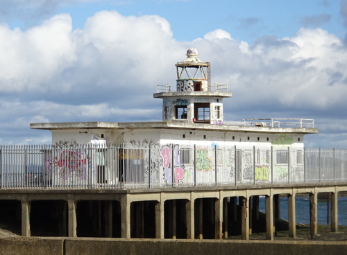
* Leith West Breakwater
1938 (station established 1828). Inactive since 2008. Approx. 10 m (33 ft) octagonal cylindrical tower rising from a 1-story building, all painted white. Heather Craven's photo is at right, Spencer has photos, a photo and another good photo are available, Marinas.com has aerial photos, Kris Denes has a 2018 street view, and Google has a fine satellite view. Gravely endangered: a large portfolio of 2008 photos shows the poor condition of this abandoned and vandalized lighthouse, and a July 2021 feature in EdinburghLive shows no improvement. Located at the end of the breakwater in Leith. This lighthouse was formerly in an industrial dockyard area, but the area has been redeveloped and there is now a park next to the lighthouse. Accessible by walking the pier. Site open, tower closed. Owner/site manager: Forth Ports PLC (?). ARLHS SCO-120; ex-Admiralty A2885.5; ex-NGA 2372.

West Breakwater Light, Leith, August 2018
photo copyright Heather Craven; used by permission
* Burntisland East Breakwater (relocated to Leith)
1876. Inactive since the mid 1950s. 7 m (23 ft) octagonal cylindrical sheet iron tower with lantern and gallery, painted white with black trim. Scott Denham 's photo is at right, Tom Parnell has a 2010 photo, Scott Liddell has a photo, Maciej Markiewicz has a street view, and Google has a satellite view. Thanks to Bill Newman for researching the identity of this lighthouse: he found it was originally at the end of the east breakwater at Burntisland. The lighthouse was active at least as late as 1954. It was relocated across the Firth of Forth to Leith in 1990. Located at Tower Place on the west side of the Water of Leith, a small estuary that curves through the downtown area of the city. Site open, tower closed.
Leith East Breakwater (2)
1937 (station esatblished 1861). Active; focal plane 7 m (23 ft); red light, 2 s on, 2 s off. 4 m (13 ft) octagonal stone tower with lantern. Lighthouse painted white, lantern red. Sandy Gemmill has a photo, Trabas has a photo by Günther Hess, Spencer has a photo, Lighthouse Accommodations has a photo (bottom of the page), a 2021 closeup is available, the light appears in the right background of a photo of the west pier lighthouse, and Google has a satellite view. Located at the end of the east breakwater pier of the Leith Docks. Site and tower apparently closed. Owner/site manager: Forth Ports PLC. Admiralty A2884; NGA 2368.

Burntisland East Breakwater Light at Water of Leith, June 2007
Flickr Creative Commons photo by Scott Denham

East Lothian Lighthouses
East Lothian is a council area and historic county located on the south side of the entrance to the Firth of Forth. The population is about 100,000.
Fidra Island
1885 (Thomas and David A. Stevenson). Active; focal plane 34 m (112 ft); four white flashes, separated by 2.7 s, every 30 s. 17 m (56 ft) round brick tower with lantern and gallery. Tower painted white with buff trim, watch room buff, lantern black. Schrage has a page for the lighthouse, Dave Ferris has a photo, Richard Webb has a 2009 closeup, Trabas has a photo, Jarrett Hiles has a 2022 photo of the light in action, Marinas.com has good aerial photos, Huelse has a historic postcard view, and Google has a satellite view. Operation of the lighthouse was transferred from NLB to Forth Ports in 2013. Fidra is said to be the inspiration for Robert Louis Stevenson's book Treasure Island. Like Bass Rock, it is an important nesting ground for seabirds. Located on the northwest corner of the island, about 3 km (2 mi) northwest of North Berwick. Accessible only by boat. Site and tower closed; the best way to see the light is on cruises from the Scottish Seabird Centre in North Berwick. Operator: Forth Ports PLC. Site manager: Royal Society for the Protection of Birds (Fidra Nature Reserve). . ARLHS SCO-080; Admiralty A2868; NGA 2352.
Bass Rock
1903 (David A. Stevenson). Active; focal plane 46 m (151 ft); three white flashes, separated by 2.5 s, every 20 s. 20 m (66 ft) round cylindrical tower with lantern and gallery, attached to a 1-story keeper's house. Tower painted white with buff trim, lantern buff with a black dome. A photo by Stefan Klaas is at right, LighthouseAccommodations has a page for the lighthouse, Schrage also has a page, Lee Kindness has a good photo, Spencer has photos, Trabas has a view from the sea, Marinas.com has aerial photos, Huelse has a historic postcard view, and Bing has a satellite view. Bass Rock is a steep crag on the southern entrance to the Firth of Forth, rising 107 m (351 ft) above the sea. Richard Webb has a photo of the gannets surrounding the lighthouse. It is an important nesting ground for seabirds, especially gannets; the common northern species was named Morus bassanus for the island. The island is privately owned. Located about 5 km (3 mi) northeast of North Berwick. Accessible only by boat. Site and tower closed; the best way to see the light is on cruises from the Scottish Seabird Centre in North Berwick. Operator: Northern Lighthouse Board. . ARLHS SCO-018; Admiralty A2864; NGA 2344.
[South Carr Beacon]
1844 (Alan Stevenson). Unlit daybeacon. 12 m (40 ft) round unpainted stone tower topped by a cross. Colin Murray has a photo and Google has an indistinct satellite view. Located about 500 m (0.3 mi) off Seacliff Beach at the southern entrance to the Firth of Forth. Accessible only by boat. Site open, tower closed.

Bass Rock Light, Firth of Forth, July 2017
Flickr Creative Commons photo by Stefan Klaas
* Barns Ness
1901 (David A. Stevenson). Inactive since 2005. 37 m (121 ft) round stone tower with lantern and gallery, attached to a 1-story service building. Tower painted white; lantern dome is black. The two 1-story keeper's houses and other light station buildings are leased as private residences. Richard West's photo is at the top of this page, Schrage has a good page for the lighthouse, Richy Hypno has a closeup 2020 photo, Walter Baxter has a 2008 photo, Huelse has a historic postcard view, and Google has a satellite view and a distant street view. This lighthouse, which marks the southern entrance to the Firth of Forth and Edinburgh, was deactivated on 24 October 2005. In 2006 the Northern Lighthouse Board placed the light station on sale, and it was sold for more than £100,000 to the Lafarge Company, which already owned the keeper's houses as well as a large quarry nearby. The prinicpal keeper's house is available for overnight accommodations. The area surrounding the light station is a public preserve, with free parking and beach access. Located just off the beach about 5 km (3 mi) east of Dunbar. The entrance to the area is gated, but a carpark and picnic area are apparently open on a schedule not available online. Tower closed. Owner/site manager: Lafarge Companies. . ARLHS SCO-015; ex-Admiralty A2854; ex-NGA 2328.

Scottish Borders: Berwickshire Lighthouses
Scottish Borders is a large council area in the southeastern corner of Scotland. It includes the area of four hisroric counties; the coastal area was in the historic county of Berwickshire.

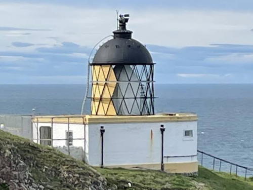
* St. Abbs Head
1862 (David and Thomas Stevenson). Active; focal plane 68 m (223 ft); white flash every 10 s. 9 m (30 ft) domed lantern on the roof of a 1-story service building. 1st order Fresnel lens in use. Building painted white, lantern black. This station was the site of Scotland's first fog siren (1876-1987). The keeper's house is atop the 90 m (300 ft) cliff; a flight of stairs leads steeply down to the lighthouse. Walter Baxter's photo is at right, LighthouseAccommodations has a page for the lighthouse, Schrage also has a page, Chas Simpson has a 2019 photo, Trabas has an excellent photo by Arno Siering that has a perspective similar to Huelse's historic postcard view, Marinas.com has spectacular aerial photos, and Bing has a good satellite view. An assistant keeper's cottage is avilable for overnight accommodations. The cape is named for St. Æbbe, the abbess of a seventh century monastery; foundations of the monastery have been found near the lighthouse. Located on a spectacular rocky headland about 8 km (5 mi) north of Eyemouth. Accessible by aa single-lane road or by popular hiking path of about 7 km (4 mi) round trip. Site open, tower closed. Operator: Northern Lighthouse Board. Site manager: National Trust for Scotland (St. Abbs National Nature Reserve). . ARLHS SCO-224; Admiralty A2850; NGA 2320.
* Eyemouth Promenade
Date unknown. Active; focal plane about 9 m (30 ft); continuous red light. Light mounted at the gable end of a 2-1/2 story masonry building. Trabas has a photo, Spencer has a photo, Google has a street view, and Bing has a satellite view. This is a directional light guiding small craft in their approach to the narrow harbor entrance. Located on the Promenade in Eyemouth. Site open, tower closed. Admiralty A2841.5.
St. Abbs Head Light
St. Abbs Head Light, Eyemouth, October 2011
Geograph Creative Commons photo by Walter Baxter

Information available on lost lighthouses:

Notable faux lighthouses:

Adjoining pages: North: Eastern Scotland | South: Northeastern England

Return to the Lighthouse Directory index | Ratings key

Posted September 9, 2004. Checked and revised August 18, 2023. Lighthouses: 44. Site copyright 2023 Russ Rowlett and the University of North Carolina at Chapel Hill.