Lighthouses of the United Kingdom: Southern England

The United Kingdom (officially the United Kingdom of Great Britain and Northern Ireland) includes England, Scotland, Wales, and Northern Ireland. England is the largest and most populous of the four, occupying more than 62% of the island of Great Britain and with a population of more than 56 million. Separated from the European mainland by the North Sea on the east and the English Channel on the south, it also has coasts facing the Celtic Sea on the southwest and the Irish Sea on the northwest.

Historically England was divided into 39 counties. The Directory pages are organized by the modern division of England into 48 "ceremonial" counties, also called lieutenancy areas because each one has a Lord Lieutenant representing the monarch in that area. For local government the ceremonial counties are subdivided in various ways into council areas.

This page includes lighthouses along the central south coast in the counties of East Sussex, West Sussex, Hampshire, Isle of Wight, and Dorset. This coastline, facing the English Channel, features several of the oldest and most famous light stations in the world. Southampton is the most important port on this coast, but there are many smaller ports.

Lighthouses of Cornwall and Devon are on the Southwest England page, and lighthouses of Kent are on the Southeastern England page.

The English system of lighthouse administration is decentralized, with the major towers under the management of Trinity House (a corporation chartered by the Crown) and smaller towers generally under the control of local port authorities. This system has generally assisted lighthouse preservation, and so has the British custom of building very sturdy stone lighthouses at most of the stations. Most of the onshore lighthouses are accessible to visitors and several of them are major tourist attractions.

These are among the very first lighthouses in Volume A of the Admiralty List of Lights & Fog Signals. ARLHS numbers are from the ARLHS World List of Lights. U.S. NGA numbers are from Publication 114.

General Sources
Trinity House
Chartered by Henry VIII in 1514 as a charitable organization, Trinity House has built and operated lighthouses in Britain since 1609.
Photographers Resource - Lighthouses
A comprehensive guide to British lighthouses, with multiple photos and historical notes for many of the light stations.
Lighthouses in England
Photos available from Wikimedia; many of these photos were first posted on Geograph.org.uk.
Online List of Lights - England
Photos of lighthouses and minor aids to navigation posted by Alexander Trabas.
United Kingdom Lighthouses
Aerial photos posted by Marinas.com.
Leuchttürme.net - Kent, Sussex Counties
Photos posted by Malte Werning; Hampshire lighthouses are also included in this collection.
Britische Leuchttürme auf historischen Postkarten
Historic postcard images posted by Klaus Huelse.
Association of Lighthouse Keepers
Founded by serving and retired keepers, this lighthouse association is open to everyone.
GPSNauticalCharts
Navigational chart information for the English Channel.
Navionics Charts
Navigational chart for the English Channel.


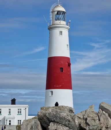
1906 Portland Bill Light, Portland, September 2023
Instagram photo by Janet Comer
East Sussex Lighthouses

The historic county of Sussex was divided in 1974 into the two ceremonial counties of East Sussex and West Sussex. East Sussex is divided into six districts, one of them being the independent (unitary) City of Brighton and Hove. The rest of the ceremonial county has 2-tier government by the East Sussex Council and five district councils.

Rother District Lighthouse
* Rye East Arm
Date unknown. Active; focal plane 7 m (23 ft); nine quick white flashes every 15 s. Approx. 8 m (26 ft) square wood skeletal tower. Fog horn (blast every 30 s). Trabas has Eckhard Meyer's photo, Bressons Puddle has a photo, and Google has a satellite view. Located at the end of the east groin at the entrance to Rye; the pier is walkable at low tide but submerged at high tide. Site open, tower closed. Admiralty A0864.5; NGA 1212.

Hastings District Lighthouse
* Hastings Range Rear (West Hill)
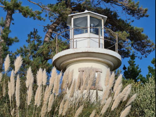
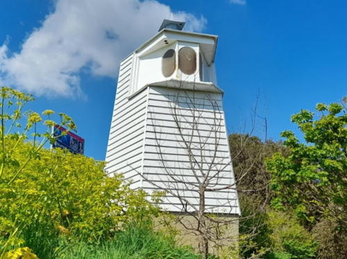
Date unknown. Active; focal plane 55 m (180 ft); continuous red light. 6 m (20 ft) pentagonal wooden tower, painted white; the light is shown through three elliptical windows near the top of the tower. A 2023 photo is at right, an excellent closeup and a 2021 closeup are available, Trabas has a photo, and Google has a street view and a satellite view. The front light is on a mast on the Hastings waterfront. Located on West Hill on the west side of Hastings Old Town. The area is accessible via the West Hill Lift, a funicular railway that climbs the hill from George Street. Site open, tower closed. Operator: unknown. ARLHS ENG-285; Admiralty A0858.1; NGA 1168.

Eastbourne District Lighthouses
#Royal Sovereign
1971 (lightship station established 1875). Deactivated and demolished in 2023. This was an octagonal tower with lantern mounted at one corner of a rectangular 1-story keeper's quarters, all supported by a huge cylindrical concrete column. The roof of the keeper's quarters was a helipad. Tower painted white with a single red horizontal band; keeper's quarters painted white. Photographers Resource has a closeup photo (second photo on the page), Trabas has a photo by Kees Aalbersberg, and Ian Paterson has a long-range view from Eastbourne. The station was automated in 1994. In 2019 Trinity House announced that the light had reached its design lifetime and would be removed. Requests for proposals were sought in September 2021, the light was extinguished on 21 March 2022, and the removal was carried out in 2023. The light tower was saved and donated to the Bexhill Maritime Coastal Enviroment Centre for restoration and public display. Located in the English Channel about 9 km (5.5 mi) east southeast of Eastbourne. Accessible only by boat. Site and tower closed. Former operator: Trinity House. . ARLHS ENG-257; ex-Admiralty A0843; NGA 1144.

Range Rear (West Hill) Light, Hastings, June 2023
Gogle Maps photo by Robsteriark Noneofyourbusiness
* Sovereign Harbour Marina (Langney Point, Eastbourne)
Date unknown (tower built 1805-06). Active; focal plane 12 m (39 ft); three white flashes every 15 s. 10 m (33 ft) round unpainted concrete tower; the light is mounted on a 1-story observation room atop the tower. Rocky Nye has a photo, Trabas has Eckhard Meyer's photo and Google has a street view and a satellite view. This is Martello Tower 66, one of the best preserved of many similar fortifications built along the Channel coast in the early 1800s. Located on the south side of the entrance to Eastbourne's harbor. Site open, tower closed. . Admiralty A0848; NGA 1150.
Beachy Head
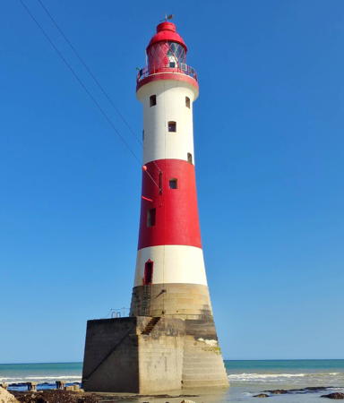
1902. Active; focal plane 31 m (102 ft); two white flashes, separated by 4 s, every 20 s. 43 m (141 ft) tapered round granite tower with lantern and gallery, mounted on a square concrete pier. Lighthouse painted white with a broad red horizontal band; lantern is also red. Fog horn (blast every 30 s). A 2023 photo is at right, Andy Beecroft has a nice 2010 photo, Werning has a good photo, Trabas has a fine closeup by Klaus Kern, Wikimedia has numerous photos, Marcin Krzan has a view from the top of the cliff above the lighthouse, Steven Chantrey has a closeup beach view from the base pf the cliff, Huelse has a historic postcard view, Marinas.com has aerial photos, and Google has a satellite view. This lighthouse replaced the Belle Tout Light (next entry). Rarely is such a large lighthouse so dwarfed by its surroundings. In January 2010 Trinity House proposed to deactivate this light but following opposition from local boaters it agreed in May to continue the light at reduced power. The fog horn was discontinued. In 2011 there was concern about the need to repaint and restore the lighthouse, a task Trinity House said it could not afford. In October preservationists began a "Save Our Stripes" campaign to raise the funds for repainting the iconic red and white daymark. This campaign reached its £27,000 goal in November 2012 and the lighthouse was repainted in September and October 2013. Rob Wassell has an account of this campaign. In 2019 Trinity House installed additional solar panels to increase the range of the light in connection with the upcoming removal of the Royal Sovereign Light (the current range is listed as 29.6 km (18.5 mi), twice the previously reduced range). Located on the beach below the Seven Sisters Cliffs about 5 km (3 mi) southwest of Eastbourne and 2.5 km (1.5 mi) east of the Belle Tout lighthouse. Each spring at a time of lowest possible tides there is a guided Lighthouse Challenge walk to the lighthouse. Otherwise site and tower closed; the lighthouse is best viewed, with care, from the clifftop above (not recommended if you have a fear of heights). Operator: Trinity House. . ARLHS ENG-005; Admiralty A0840; NGA 1140.

Beachy Head Light, Eastbourne, June 2023
Google Maps photo by Legendary
* Belle Tout (Belle Toute)
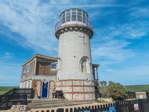
1832 (James Walker). Inactive since 1899. 14 m (47 ft) round stone tower with lantern and gallery attached to modern 2-story residence. Tower unpainted, lantern painted white. A 2022 street view by Phil Rhodes is at right, Werning has a good closeup, another closeup photo is available, Wikipedia has an article with a photo, Huelse has a historic postcard view, Marinas.com has aerial photos, Robert Wilson has a street view, and Google has a satellite view. The lighthouse was replaced by the Beachy Head Light because its light, shown at a height of 87 m (285 ft) from atop the Seven Sisters Cliffs, was often obscured by fog or low cloud. The lighthouse was built 30 m (100 ft) from the edge of the cliff, but by the 1990s erosion had brought it nearly to the edge. In 1999 the lighthouse was relocated 15 m (50 ft) inland. In 2007 the lighthouse was listed for sale at £850,000. The Belle Toute Preservation Trust was formed and tried to purchase the lighthouse and convert it to a bed and breakfast inn. These plans were approved by local authorities in September 2007, but before funds could be raised the lighthouse was sold in March 2008 to David and Barbara Davison Shaw, who announced that they would convert the lighthouse to a bed and breakfast inn and tea shop. Renovations were in progress in 2009 and the accommodations were open for the 2010 season. The lighthouse is still endangered by erosion and the new owners say they think the lighthouse will have to be moved again within the next 20 years. A major cliff section collapsed nearby in August 2021, suggesting that schedule may have to be advanced. Located off Beachy Head Road about 6 km (3.5 mi) southwest of Eastbourne. Parking is available east of the lighthouse. Site and tower closed but the lighthouse can be viewed from nearby. Owner/site manager: Belle Tout Lighthouse . ARLHS ENG-006.

Belle Tout Light, Eastbourne, May 2022
Google Maps street view by Phil Rhodes

Lewes District Lighthouses
* #Newhaven East Pier (1)
1883. Demolished in 2006. This was an 11.5 m (38 ft) square iron skeletal tower with lantern and gallery; watch room enclosed by wood siding. Tristan Forward has a sunrise photo and Werning also has a good photo. This little lighthouse was demolished in early 2006 and replaced by a modern light on a post (focal plane 12.5 m (41 ft); green light, 5 s on, 5 s off). Trabas has Eckhard Meyer's photo and Google has a street view and a satellite view. Not to be confused with another Newhaven East Pier Light on the Firth of Forth in Edinburgh, Scotland. Located at the end of the east pier of Newhaven. Accessible by walking the pier. Site open. Operator: Newhaven Port Authority. ARLHS ENG-235. Active light: Admiralty A0832; NGA 1132.
* Newhaven Breakwater
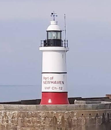
1891. Active; focal plane 17 m (56 ft); white light, two 1 s occultations every 10 s. 14 m (46 ft) round cylindrical cast iron tower with lantern and gallery, painted white with a red band at the base. Fog horn (blast every 30 s). Leon Stonebank's photo is at right, Werning has a good photo, Trabas has Thomas Philipp's photo, Jason Ryan also has a good photo, Marinas.com has aerial photos, and Google has a satellite view. A 2022 view from the sea shows the lighthouse feshly repainted. Located at the end of the long breakwater on the west side of the harbor of Newhaven. Accessible by walking the breakwater, which is popular for fishing and sightseeing. Site open, tower closed. Operator: Newhaven Port Authority. ARLHS ENG-086; Admiralty A0830; NGA 1136.

Brighton and Hove City Lighthouse
* Brighton Marina West Breakwater
Date unknown (probably late 1970s). Active; focal plane 10 m (33 ft); quick-flashing red light. 5 m (17 ft) round cylindrical concrete tower, painted white. Trabas has Eckhard Meyer's photo, Simas Anužis has a 2019 street view, and Google has a satellite view. Located at the end of the west breakwater enclosing the marina, on the east side of Brighton. Accessible by walking the pier. Site open, tower closed. Site manager: Brighton Marina. ARLHS ENG-284; Admiralty A0826; NGA 1121.

Newhaven Breakwater Light, Newhaven, December 2020
Google Maps photo by Leon Stonebank

Greenwich Lightship
Trinity House Lightship Greenwich
Station established 1995. Active; focal plane 12 m (39 ft); white flash every 5 s. 40.5 m (133 ft) steel lightship, painted red. The light is shown from a lantern on a round light tower amidships. The station has been served by many vessels over the years. Shipspotting.com has a 2009 photo of lightship LV-22 carrying the nameplate of the Greenwich station, taken at Harwich on 18 October 2009. David Emsley has a 2011 photo but the ship is not seen in Google's satellite view. Located on the Meridian of Greenwich (longitude 0°), 46 km (29 mi) south of Newhaven, the station marks the "median" between the eastbound and westbound routes of the English Channel Traffic Separation Scheme. Accessible only by boat. Site open, vessel closed. Owner/site manager: Trinity House. ARLHS ENG-269; Admiralty A0839; NGA 1128.

West Sussex Lighthouses

The historic county of Sussex was divided in 1974 into the two ceremonial counties of East Sussex and West Sussex. West Sussex is divided into seven districts, including two having the status of boroughs.

Adur District Lighthouses
* Shoreham Middle Pier Range Front (3?)
Date unknown. Active; focal plane 8 m (26 ft); white light, 3 s on, 2 s off. 6 m (20 ft) post rising from a 1-story equipment building. Originally the light was on the roof of the harbormaster's office. Eckhard Meyer's closeup photo posted by Trabas and Simon Carey's 2007 photo shows the new structure. Google has a satellite view and a street view across the harbor. Located at the end of the middle pier, inside the inlet at Shoreham-by-Sea, about 8 km (5 mi) west of Brighton. Site open, tower closed. Operator: Shoreham Port Authority. ARLHS ENG-313; Admiralty A0814; NGA 1112.
* Shoreham Middle Pier Range Rear (Kingston Buci)
1846. Active; focal plane 13 m (43 ft); white flash every 10 s. 12 m (39 ft) round limestone tower with lantern and gallery. Lighthouse is unpainted gray stone; lantern is black. Phil Lev's photo is at right, Werning has a fine photo, Trabas has Arno Siering's closeup photo, Wikimedia has several photos, a wintry photo of the beach and lighthouse is available, Martin Deane has a 2023 photo, and Google has a street view and a satellite view. The lantern was reconstructed in 1985. The Shoreham Harbour Lifeboat Station is adjacent to the lighthouse. Located on Brighton Road (A259) near the base of the middle pier in Shoreham-by-Sea, about 8 km (5 mi) west of Brighton. Site open, tower closed. Operator: Shoreham Port Authority. . ARLHS ENG-125; Admiralty A0814.1; NGA 1116.

Arun District Lighthouses
Littlehampton Approaches
Date unknown. Active; focal plane 9 m (30 ft); five yellow flashes every 20 s. 9 m (30 ft) robust mast with a gallery carrying meteorological instruments. A closeup photo is available and Trabas has a very distant view but the light is not shown in Google's satellite view. Located about 5 km (3 mi) southeast of Littlehampton. Accessible only by boat. Admiralty A0809; NGA 1098.
* Littlehampton East Pier Range Rear (2)
1948 (station established 1848). Active; focal plane 9 m (30 ft); light 6 s on, 1.5 s off, showing white over the channel to the south southeast and yellow toward the south southwest. Approx. 7 m (23 ft) concrete tower with four tapering buttresses and a cylindrical lantern. Werning has a good photo, Paul Gillett has a 2010 photo, Julius Agricola has a photo, Trabas also has a photo, Wikimedia has a view from the harbor, Travis Hayler has a closeup street view, and Google has a satellite view. There are postcard views (halfway down the page) of the original lighthouse, a hexagonal wood tower. It became the rear light of a range in 1868. The two range lighthouses were demolished in 1940 and there was no light until the present tower was built in 1948. HM Coast Guard Littlehampton is adjacent to the lighthouse. The current front light is on a post on the east pier. Located near the foot of the pier, at the end of Pier Road, on the Littlehampton waterfront. Site open, tower closed. Operator: Littlehampton Harbour Board. . ARLHS ENG-066; Admiralty A0801.1; NGA 1084.

Middle Pier Range Rear Light, Shoreham, February 2021
Google Maps photo by Phil Lev
* Pagham Yacht Club
Date unknown. Actv; focal plane about 12 m (39 ft); continuous white (?) light. Square wood observation room carrying a red triangular daymark and centered on a 1-story yacht club building. Trabas has Eckhard Meyer's photo and Google has a beach view and a satellite view. Located at the intersection of Beach Road and Front Road in Pagham. Site open, tower closed. Admiralty A0792.

Chichester District Lightbeacons
[The Mixon]
Date unknown. Active; focal plane about 10 m (33 ft); six quick light flashes followed by one long white flash every 15 s. Approx. 10 m (33 ft) post supported by pyramidal braces at the base. Upper half of the post painted yellow, lower half black. Trabas has Eckhard Meyer's photo but the light is not shown in Google's satellite view. The Mixon is a limestone reef extending from the headland of Selsey Bill, about 18 km (12 mi) east southeast of Portsmouth. The reef was formerly exposed, but so much limestone was quarried from it the reef is now almost entirely submerged. Located about 1.6 km (1 mi) off Selsey Bill. Accessible only by boat. Site open, tower closed. Admiralty A0790; NGA 1066.
[West Pole (2?)]
Around 2007. Active; focal plane 14 m (46 ft); red flash every 5 s. 14 m (46 ft) triangular skeletal tower supported by three robust piles. Trabas has a photo and another photo is available but the light is not shown in Google's satellite view. Located about 2.5 km (1.5 mi) south of the entrance to Chichester Harbour, marking the start of the dredged approach. Accessible only by boat. Site open, tower closed. Admiralty A0783.5; NGA 1046.

Hampshire Lighthouses

The historic county of Hampshire surrounds and includes the largest ports of England's south coast. It is separated from the Isle of Wight by a strait called the Solent and a broad northern inlet of the Solent, Southampton Water, leads to the port of Southampton. The ceremonial county includes the independent cities of Portsmouth and Southampton; the rest of the county has a 2-tier government with a county council and eleven non-metropolitan district or borough councils.

Portsmouth City (Southsea) Lighthouse
The city of Portsmouth is located on Portsea Island facing the eastern entrance to the Solent. The island is separated from the mainland to the north by a narrow channel and from Gosport on the west by the bay of Portsmouth Harbour. The resort area on the south side of the island and city is known as Southsea.
Horse Sand Fort
1866. Active; focal plane 21 m (69 ft); green light, 1 s on, 1 s off. Light on a mast mounted atop the fort. Trabas has a photo by Thomas Philipp, Chris Gunns has a closeup, Wikipedia has an article including a photo, another photo is available, and Bing has a satellite view. In 2012 the fort was purchased by Clarenco, the owner of Spitbank Fort. Horse Sand Fort has been restored to its World War II condition and has been operated as a museum. In October 2021 Clarenco sold the fort for £715,000. Located on the east side of the Portsmouth entrance channel about 3.5 km (2.1 mi) south of Southsea. Accessible by passenger ferry from the Gunwharf Quays in Portsmouth Harbour. Site open, tower closed. Owner: Solent Forts. Operator: Spitbank Fort. . ARLHS ENG-225; Admiralty A0750; NGA 1028.
* Spitbank Fort
1866. Active; focal plane 18 m (59 ft); red flash every 5 s. Approx. 7 m (23 ft) round cylindrical tower with lantern centered on 1-story square service building, mounted atop the fort. Light tower painted red with one white horizontal band. Werning has a photo, Trabas has a good photo by Thomas Philipp, Wikimedia has a photo, and Google has a satellite view. Spitbank Fort is one of four circular, heavily armored stone forts built off Portsmouth between 1860 and 1885. Each of the forts has a light tower. The fort is a privately owned tourist attraction. Overnight accommodations became available in June 2006. In 2010 the fort was closed for renovations; it reopened for 2011. In 2022 the fort was for sale for £3 million. Located in the harbor entrance about 1 km (0.6 mi) off Southsea. Accessible by passenger ferry from the Gunwharf Quays in Portsmouth Harbour. Site open, tower closed. Owner: Solent Forts. Operator: Spitbank Fort . ARLHS ENG-260; Admiralty A0688; NGA 0948.
* Southsea Castle
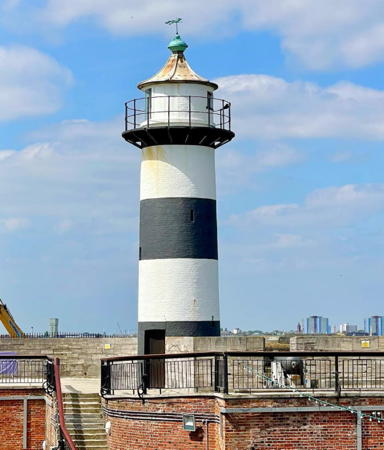
1828. Inactive since 2018. 10 m (33 ft) round cylindrical stone tower, painted white with a black horizontal band. Alan Goodger's2022 photo is at right, Trabas has a closeup photo by Arno Siering, Graham Horn has a 2010 photo, Werning has a photo, and Google has a street view and a satellite view. Trabas also has Thomas Philipp's photo of the offshore Castle Pile Light (Admiralty A0690.8), which has taken over the function of the historic lighthouse as the leading light for ships entering Portsmouth. Southsea Castle was built by Henry VIII in 1544. Located atop the western rampart of the castle, marking the east side of the entrance to Portsmouth Harbour. Site open, castle open daily late March through October; tower closed. Operator: unknown. Owner: Portsmouth City Council. Site manager: Southsea Castle. . ARLHS ENG-134; ex-Admiralty A0691; NGA 0956.

Southsea Castle Light, Portsmouth, May 2022
Instagram photo by Alan Goodger
Portsmouth Round Tower
Date unknown (tower built in the 1490s). Active; focal plane about 15 m (49 ft); continuous green light. Light mounted on the side of a large late medieval fortification. Trabas has a photo, Wikipedia has a photo, and Google has a satellite view. Built in the early 15th century, the Round Tower is open to tourists and contains an art gallery and a café. Located on the seaward side of the Round Tower marking the east side of the narrow entrance to Portsmouth Harbour. Owner: Portsmouth City Council. Site open. Admiralty A0699.

Gosport Borough Lightship and Lighthouse
The town of Gosport is located on a peninsula on the west side of Portsmouth Harbour and the north side of the Solent. Historically it has been an important base for the Royal Navy, although some of the naval facilities have closed in recent decades.
** Trinity House Lightship 1 Haslar Marina
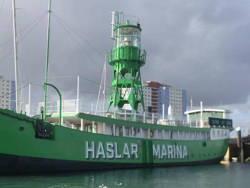
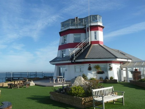
1946. Decommissioned 1993. 36. 3 m (119 ft) two-masted steel lightship; hexagonal skeletal light tower with lantern and gallery amidships. Entire vessel painted green. Built by Philip and Son, Ltd., of Dartmouth. A photo is at right, Christine Matthews has a photo, Peter Trimming has a good photo, Con Burnes has a street view, and Google has a satellite view. The ship served first as the Royal Sovereign and was posted to numerous stations around the English coast before returning to the Royal Sovereign station as the last lightship posted there in 1971. Sold as a marina club vessel, she was named Mary Mouse 2 for the wives of two directors of the Portsmouth Yacht Club. However, the name Haslar Marina appears now on the side of the vessel. Formerly available only for business functions, the lighthouse was opened to the public as a restaurant in 1993. The restaurant closed in October 2021 and new management was being sought. In June 2023, a new restaurant opened on the ship. Located at the Haslar Marina on Haslar Road on the north side of the harbor in Gosport; Marinas.com has aerial photos. Site open, vessel open for dining daily. Owner: Boatfolk Marinas Ltd. Site manager: The Lightship at Haslar Marina. . ARLHS ENG-319.
Fort Blockhouse
Date unknown. Active; focal plane 6 m (20 ft); white, red or green lights, continuous or alternating depending on direction. Light mounted on a square National Coastwatch tower built at one corner of the historic Fort Blockhouse. Ben Kirby has a 2018 photo, Tjaart Molenkamp has a photo, Trabas has Eckhard Meyer's photo, and Google has a satellite view. This is the leading light for the main channel entering Portsmouth. Located on the west side of the narrow entrance to Portsmouth harbor across from the Round Tower. Site and tower closed (military installation). Admiralty A0692.5; NGA 0960.

Haslar Marina Lightship, Gosport, July 2016
ex-Google Maps photo

Southampton City Lightship and Lighthouses
Located at the northern end of the Southampton Water estuary, Southampton is a city of about 300,000 residents. Long a traditional departure point for transatlantic travel, it is now a major center of the cruise ship industry.
Trinity House Lightship 78 Calshot Spit
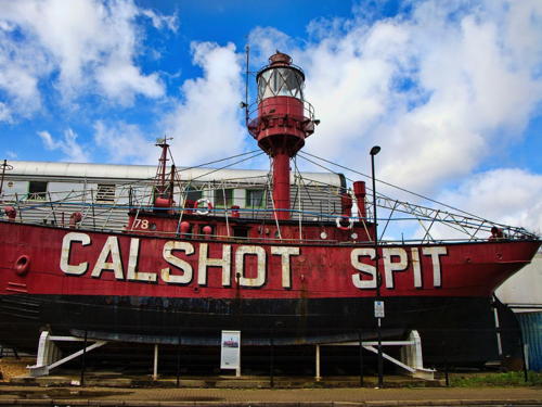
1914 (J.I. Thornycroft Ltd.). Decommissioned 1978. 24 m (78 ft) single-masted steel lightship, painted red. The light was shown from a large lantern at the top of the mast. Formerly stationed off Calshot Spit, at the western entrance to Southampton Water from the Solent; there's a good photo of the ship on station. The lightship was replaced off Calshot Spit by a lightfloat (see below). The decommissioned ship was displayed on land for many years at the Ocean Village Marina in Southampton. Steve Daniels has a 2010 photo showing it at the marina. In November 2010 the ship was removed and relocated to Berth 50 near the cruise ship terminal. David Howard has a June 2014 photo of the relocated lightship. The plan was for the ship to be one of the exhibits of a museum called Aeronautica. However, in 2012 the museum site was redirected to another purpose. A September 2017 photo by Gareth James shows the lighthouse in apparently good condition but still stranded at Berth 50. In December 2019 the ship was moved again, this time to the Solent Sky Museum, an aviation museum at Royal Cres and Saltmarsh Roads not far from its former home at the Ocean Village Marina. Google has a satellite view and the street view of the lightship at right. The ship will be restored and linked to the museum's café; it was expected to reopen in 2021. Site open, vessel currently closed. Owner/site manager: Solent Sky Museum. Site manager: unknown. . ARLHS ENG-021.
* Town Quay Range Front (2)
Date unknown. Active; focal plane 12 m (39 ft); continuous white light. The light and a yellow triangular daymark are mounted low on a 35 m (115 ft) square skeletal radar tower. Trabas has Rainer Arndt's photo and Google has a satellite view. Google's 2008 street view shows the light on a shorter tower without the radar antenna. The range guides ships on their final approach to the Southampton passenger and cruise ship terminal. Located at the end of a broad pier is in use as the Town Quay Car Park. Site open, tower closed. Admiralty A0626; NGA 0844.

Calshot Spit Lightship at the Solent Sky Museum, Southampton, September 2020
Google Maps street view
Royal Pier (Town Quay Range Rear)
Date unknown. Active; focal plane 22 m (72 ft); continuous white light. 23 m (75 ft) square skeletal tower carrying a diamond-shaped yellow daymark. Trabas has a photo and Google has a satellite view. Located on a pier 410 m (1/4 mi) northwest of the front light. Site and tower closed. Admiralty A0626.1; NGA 0848.

New Forest District Lighthouses
Calshot Castle
1888. Inactive. Robust round stone tower, completed in 1540 at the order of King Henry VIII. A continuous white light was shown from the castle, and there are references to it at least until 1920. A modern National Coastwatch tower and the tall Southampton vessel traffic control tower stand next to the castle. Robert Zorlakki has a 2018 photo, Rafal Reed has a 2017 photo, and Google has a street view and a satellite view. Located at the end of Calshot Spit, on the west side of the entrance to Southampton Water from the Solent. Site open, castle open to tours. Owner/site manager: English Heritage (Calshot Castle).
[Calshot Spit Lightfloat (2)]
2015. Active; focal plane 12 m (39 ft); white flash every 5 s. 11 m (36 ft) cylindrical aluminum tower mounted on a catamaran platform. Fog horn. Entire lightfloat is red. This light replaces the historic Calshot Spit lightship. Maritime Journal has a photo and the history of the station and Bing has an indistinct satellite view. Ben Hollier has a 2011 photo of the previous lightfloat. The Admiralty and NGA lists have dropped listings of most lightfloats and offshore buoys in recent years. Located about 1 mi (1.6 km) southeast of Calshot Castle. Accessible only by boat. Site open, lightfloat closed. ex-Admiralty A0576; ex-NGA 0660.
* Beaulieu River (Millennium Beacon)
2000. Active (privately maintained); focal plane 13 m (43 ft); white, red or green light, depending on direction, occulting once every 4 s. 7.5 m (25 ft) round masonry tower with lantern and gallery. Stephanie Brogan's 2021 photo is at right, Trabas has a closeup photo, another good photo is available, Gillian Moy has a 2006 photo, and Google has a street view and a satellite view. This lighthouse was built as a Millennium project by the town of Beaulieu. The site is on the grounds of Lepe House, a manor owned by the local member of Parliament. Located on the north side of the entrance to the Beaulieu River from the Solent, about 3 km (2 mi) southeast of Exbury. Site and tower closed. Operator: unknown. Site manager: private. ARLHS ENG-277; Admiralty A0553.15.

Beaulieu River (Lepe House) Light, Beaulieu, November 2021
Google Maps photo by Stephanie Brogan
* Hurst Point Low (Hurst Castle) (2)
1866 (station established 1786). Inactive since 1911. Circular granite tower built on the walls of Hurst Castle (1544). The tower is unpainted; lantern painted dark blue or gray. Werning has a good photo, Photographer's Resource has an excellent page for the Hurst Point lighthouses, Nick Grace has a 2008 photo of both low lighthouses, Wikimedia has Dave Pape's photo of both lighthouses, and Google has a street view and a satellite view. The original lighthouse was demolished. Two rooms in the Castle house a Trinity House exhibition on lighthouses; the former optic of the Egypt Point Light and the lantern from the Nab Light are displayed outside. The Castle also has a page with historical background. Located at the end of a narrow spit extending into the Solent south of Keyhaven. Site and castle open (admission fee), towers closed. The castle is accessible by passenger ferry from Keyhaven from April through October, or by a hike of 2.5 km (1.5 mi) across the spit. Owner: English Heritage. Site manager: Hurst Castle. ARLHS ENG-253.
* Hurst Point Low (Hurst Castle) (3)
1911 (station established 1786). Inactive since 1997. Square metal tower with lantern and gallery, built on a square skeletal platform straddling the castle wall. After it was deactivated the tower was painted warship gray, as seen in Werning's photo, Nick Grace's 2008 photo of both low lighthouses, and Dave Pape's photo of both lighthouses. Google has a street view and a satellite view. In June 2010 Trinity House transferred ownership of the lighthouse to English Heritage. Located at the end of a narrow spit extending into the Solent south of Keyhaven. The castle is accessible by passenger ferry from Keyhaven from April through October, or by a hike of 2.5 km (1.5 mi) across the spit. Owner: English Heritage. Site manager: Hurst Castle. ARLHS ENG-058; ex-Admiralty A0538; ex-NGA 0592..
* Hurst Point (High) (2)
1867 (station established 1812). Active; focal plane 23 m (76 ft); four flashes every 15 s, white or red depending on direction; also a directional light, white, red or green depending on exact direction is shown at a focal plane of 19 m (62 ft) over the Needles Channel for ships entering the Solent. 26 m (85 ft) round stone tower with lantern and gallery, painted white. The original 1st order Fresnel lens is in use for the main light; the directional lights (added in 1997) are shown from high-intensity projectors mounted in the watch room below the lantern. 2-story keeper's house and other light station buildings. Ewan Cole's 2024 photo is at right, Wikimedia has Alex Liivet's 2015 photo, Werning has a nice photo, Trabas has a photo, Missy Osborn has a fine photo taken from the castle wall, Wikimedia has additional photos, Marinas.com has aerial photos, and Google has a street view and a satellite view. The leading lights were added during a restoration of the lighthouse in 1997. This famous lighthouse marks the narrow entrance to the Solent. Norman Price has a view across the strait from the Cliff End Battery on the Isle of Wight. Located near the point, just outside the wall of Hurst Castle. Accessible by passenger ferry from Keyhaven or by walking along the spit from Milford-on-Sea (about 6 km or 4 mi roundtrip). Site and tower closed, but the lighthouse can easily be viewed from outside the walls of the station. Operator: Trinity House. . ARLHS ENG-057; Admiralty A0538.1; NGA 0596.

Hurst Point High Light, Keyhaven, April 2024
Instagram photo by Ewan Cole

Isle of Wight Lighthouses

Separated from Hampshire by the strait known as the Solent, the Isle of Wight has an area of 258 square kilometers (100 square miles) and a population of about 140,000. A popular resort area, the island is accessible by air or by ferries from Portsmouth, Southampton, or Lymington. Historically the island was part of the county of Hampshire; it became a separate ceremonial county in 1972. The island is governed as unitary council area.

*
Egypt Point
1897. Inactive since 1989. 7.5 m (25 ft) post with gallery, centered on a circular 1-story metal equipment shelter. Gallery and base painted white, post red. A 2007 closeup photo is available, Mark Pilbeam has a nice photo, Patrick White has a 2021 closeup, and Google has a closeup street view and a satellite view. This modest but unusual light is very accessible and well known. Maintenance was assumed by the Isle of Wight Council in 2007, but in 2019 several residents asked that it be transferred to the Cowes Town Council. Located near the northernmost point of the Isle of Wight, on the Egypt Esplanade (Queen's Road) near Egypt Hill Road in Cowes. Owner/site manager: Isle of Wight Council. Site open, tower closed. . ARLHS ENG-180; ex-Admiralty A0648.
* No Man's Land Fort
1866. Active; focal plane 21 m (69 ft); red light, 1 s on, 1 s off. Approx 10 m (33 ft) octagonal tower with gallery attached to 1-story keeper's house, mounted atop the fort. Lantern removed; light displayed from a short mast. Lighthouse painted white with two narrow red horizontal bands. Rob Farrow's photo is at right, Wikipedia has an article with a photo, Colin Babb has a good photo, Trabas has a photo by Hartmut Knape, another photo is available, and Bing has a satellite view. The fort was developed as a luxury hotel, with helipads and a large indoor swimming pool. This venture failed around 2005 and the fort went on the market. After it was repossessed by the mortgage holder it was sold in March 2012 to Clarenco, the owner of the Spithead and Horse Sand Forts (see above). Like the Spithead Fort, the fort was redeveloped for luxury accommodations; it opened in May 2015. Tours were available and a café served lunch. However the fort closed at the start of the pandemic in 2020 and it has not reopened. Located on the west side of the Portsmouth entrance channel about 3 km (2 mi) northeast of Seaview and 4 km (2.4 mi) south of Southsea. Accessible by passenger ferry from the Gunwharf Quays in Portsmouth Harbour. Site and tower closed. Operator: unknown. Owner/site manager: Solent Forts. Site manager: No Man's Fort . ARLHS ENG-237; Admiralty A0752; ex-NGA 1032.
St. Helen's Fort
1866. Active; focal plane 16 m (53 ft); three white flashes every 10 s. Approx. 7 m (23 ft) square pyramidal skeletal tower mounted atop the fort. Bernard Bradley has a good 2009 photo, Trabas also has a good photo by Thomas Philipp, Darren Button has a closeup street view, and Google has a satellite view. At the lowest tide in August it is traditional to walk the usually-submerged causeway to the fort. Located about 1.5 km (1 mile) off St. Helens and 7 km (4.5 mi) south of Southsea. Accessible only by boat (except during the walk out). Site and tower closed. Operator: unknown. Owner/site manager: private. . ARLHS ENG-181; Admiralty A0760; NGA 0944.

No Man's Land Light, the Solent, May 2016
Geograph Creative Commons photo by Rob Farrow
Nab Tower
1920 (rebuilt in 2013-15; lightship station established 1819). Active; focal plane 17 m (56 ft); white flash every 10 s. 27 m (89 ft) cylindrical steel and concrete tower topped by a helipad and a short hexagonal light tower. Light tower painted white. Fog horn (2 blasts every 30 s). Trabas has Jim Smith's photo, Wikimedia has a 2014 photo, and Bing has a satellite view. This unusual tower was built for coastal defense in 1918 but the project was abandoned with the end of World War I. Trinity House converted the structure to a light tower and used it to replace a lightship station marking the beginning of the approach to Spithead and Portsmouth Harbour. The tower assumed a permanent 3° lean when it was emplaced. An antiaircraft battery mounted on the tower shot down several German aircraft during the Battle of Britain in World War II. A closeup photo of the original structure is available. In 2013 Trinity House stripped away everything except the underlying concrete, reduced the height of the structure by 10 m (33 ft) , and coated the remaining tower with new concrete. The lantern was removed and disassembled for restoration at Hurst Castle. Located in the English Channel southeast of Bembridge, just off the eastern end of the Isle of Wight. Site and tower closed. Operator: Trinity House. ARLHS ENG-082; Admiralty A0780; NGA 1048.
* St. Catherine's
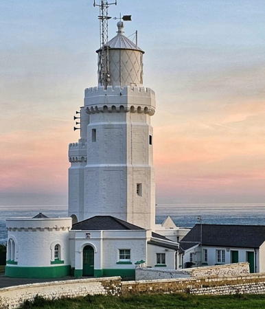
1838. Active; focal plane 41 m (135 ft); white flash every 5 s; a continuous red light (focal plane 35 m (115 ft)) is shown from a window of the tower westward over the Atherfield Ledge. 26 m (86 ft) hexagonal cylindrical stone tower with lantern and a medieval-style stone gallery. A similar, lower tower adjacent to the front of the lighthouse is a fog signal tower built in 1932 (fog signal inactive since 1987). The two towers, both painted white, are known locally as the Cow and the Calf. A 2023 photo is at right, Trabas has a great closeup by Arno Siering, Alexander Anderson has a 2019 photo, Wikimedia has photos, Alistair Young has a photo, Armand Sharp has a street view, Huelse has a historic postcard view showing the lighthouse as it appeared before the fog signal tower was added, and Google has a satellite view. This lighthouse was originally 36.5 m (120 ft) tall; it was reduced in height in 1875 because the light was too often obscured by low clouds and fog. From 1323 to 1530 a navigational light was shown from the tower of a church near the location of the lighthouse. The lighthouse itself escaped damage during a German air raid on 1 June 1943 but the three keepers were killed. The tower was open for tours for many years, but in January 2020 Trinity House announced that following the retirement of the longtime tour operator the Visitor Centre would close permanently. In 2022 Trinity House removed the 1st order lens and installed an LED system. With the help of volunteers the lens was reassembled and placed on display at the Classic Boat Museum in Cowes beginning in March 2023. Located near Niton at the southernmost point of the Isle of Wight. Site open, tower closed. Operator: Trinity House. . ARLHS ENG-143; Admiralty A0774; NGA 1064.

St. Catherine's Light, Niton, August 2023
Instagram photo
by isleofwight.com
* [St. Catherine's Hill (The Mustard Pot)]
1785. Never completed. 5 m (17 ft) unfinished round stone tower. Google has a satellite view. Intended as a lighthouse, this tower was abandoned when it was realized that frequent fogs would render it useless when most needed. Located near Chale, about 2 km (1.3 mi) north northwest of the St. Catherine's lighthouse (previous entry). Site open, tower closed.
* St. Catherine's Oratory (The Pepperpot)
1328. Inactive since at least 1547. 11 m (36 ft) octagonal cylindrical stone tower with a pyramidal top and four buttresses, making the building look remarkably like a rocket built of stone. A portfolio of photos is available, also a good closeup, Wikimedia has several photos, James Brooke has a street view, and Google has a satellite view. Originally there was a chimney opening at the top of the tower. A fire was maintained on the top floor and could be seen through eight openings. The lighthouse was built by Walter de Godeton, a nearby landowner who was convicted of receiving at least 53 casks of white wine from a ship that had wrecked in the fog on St. Catherine's Point. As punishment, he was ordered to build a lighthouse and an adjoining oratory where priests would say mass for the souls of sailors lost at sea. The lighthouse was apparently in regular operation until Henry VIII closed Catholic religious institutions in 1547. Built atop a high hill, the light had a focal plane of about 240 m (785 ft). Only foundation ruins remain of the oratory. Located about 2 km (1.3 mi) north northwest of the St. Catherine's lighthouse and 180 m (200 yd) northwest of the St. Catherine's Hill (Mustard Pot) tower (previous entry). Site open, tower closed. . ARLHS ENG-293.
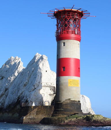
The Needles (2)
1859 (James Walker). Station established 1785. Active; focal plane 24 m (80 ft); white, red, or green light depending on direction, two 2 s occultations every 20 s. 31 m (102 ft) cylindrical granite tower, incorporating keeper's quarters, with lantern and a helipad built above the lantern. The original 2nd order Fresnel lens remains in use. Tower painted with red and white horizontal bands. Fog horn (two blasts every 30 s). Ian Hayhurst's photo is at right, Christine Matthews has a photo, Trabas has a similar photo by Arno Siering, a good closeup is available, Paul Woolrich has a 2006 photo, Wikimedia has many photos, Ray Reid has a 2018 photo, Huelse has a historic postcard view, Marinas.com has aerial photos, and Google has a satellite view. This famous lighthouse marks the western entrance to the Solent, the protected sound behind the Isle of Wight. In 2010 a £500,000 project rebuilt the base of the lighthouse, which was threatened by erosion by the sea. In 2023 Trinity House renovated and upgraded the interior, replacing obsolete equipment and installing new doors and windows. Located at the rocky western tip of the Isle of Wight, west of Alum Bay. Site and tower closed but the lighthouse can be seen from overlooks in the nearby Needles Park. Operator: Trinity House. . ARLHS ENG-083; Admiralty A0528; NGA 0584.

The Needles Light, Totland, August 2012
Flickr Creative Commons photo by Ian Hayhurst

Dorset Lighthouses

The County of Dorset occupies the English Channel coast between Hampshire on the east and Devon on the west. Since 2019 the county has been governed by two unitary authorities, the Bournemouth, Christchurch, and Poole Council for the urban area in the southeast and the County Council for the rest of the county.

Swanage Area Lighthouses
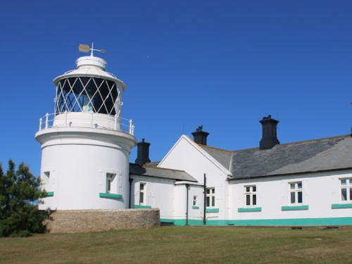
* Anvil Point
1881. Active; focal plane 45 m (149 ft); white flash every 10 s. 12 m (39 ft) round cylindrical stone tower with lantern and gallery, painted white with green trim, attached to 1-story keeper's quarters. 250 mm lens in use; the original Fresnel lens is on display at The Science Museum in South Kensington. The fog signal structure in front of the lighthouse is no longer in use, but the keeper's houses are available for overnight accommodations. Tom Haley's photo is at right, Photographer's Resource has a fine page for the lighthouse, Trabas has a good photo by Arno Siering, Wikimedia has photos, Marinas.com has aerial photos, Brian McKew has a street view from the Southwest Coast Path below the lighthouse, Huelse has a historic postcard view, and Google has a fine satellite view of the station. Located atop a cliff in Durlston County Park, at the end of Lighthouse Road about 3 km (2 mi) south of Swanage. Site and tower closed but the lighthouse can easily be viewed from outside the walls of the station. Operator: Trinity House. . ARLHS ENG-001; Admiralty A0496; NGA 0544.
* St. Alban's Head (2)
1970s (station established 1895). Active; focal plane approx. 100 m (328 ft); red light, 1 s on, 1 s off. 6 m (20 ft) signal mast adjacent to a 1-story coastwatch building. Stephen Williams has a photo, Trabas has a photo, and Google has a satellite view. Formerly a Coastguard station, the building is now owned by the Scott Trust was leased to the National Coastwatch Institution, but the Coastwatch station has been closed. Located atop a vertical cliff at a headland near Worth Matravers, about 10 km (6 mi) west of Anvil Point. Site open. Admiralty A0450.

Anvil Point Light, Swanage, October 2008
Google Maps photo by Tom Haley

Weymouth and Portland Area Lighthouses
The Isle of Portland is a "tied island," that is, it is connected to the mainland by a sandy spit. Weymouth is a resort town on the mainland a short distance to the north. Between Weymouth and the Isle of Portland a series of breakwaters built between 1849 and 1872 to create the large, sheltered, Portland Harbour, then the largest man-made harbor in the world. Portland Harbour was a major base for the Royal Navy until 1995, when the last naval facilities closed. Now it is being redeveloped as a resort and commercial harbor.
* Weymouth South Pier (Stone Pier)
Date unknown. Active; focal plane 10 m (33 ft); quick-flashing white light. 7.5 m (25 ft) mast surrounded by a circular observation deck accessed by a spiral stairway. Deck painted blue with white trim. Trabas has Andreas Köhler's photo, Robert Plant has a street view along the pier, and Google has a satellite view. Located at the end of the south pier at the entrance to the River Wey in Weymouth. Site open, observation deck open. ARLHS ENG-162; Admiralty A0346; NGA 0540.
Portland Breakwater Fort Head
Date unknown. Active; focal plane 14 m (46 ft); quick-flashing red light. 12 m (39 ft)m skeletal tower mounted atop a square stone tower. Trabas has Eric Hartmann's photo, Frank Stainer has a 2021 drone view, and Google has a satellite view. The tower is part of a nineteenth century fort. Located at the north end of the detached east outer breakwater of Portland Harbour. Accessible only by boat. Site and tower closed. Operator: Portland Harbour Authority. ARLHS ENG-107; Admiralty A0310; NGA 0456..
Portland Breakwater (A Head)
1905. Active; focal plane 22 m (71 ft); white flash every 10 s. 22 m (71 ft) hexagonal cast iron skeletal tower with central cylinder, lantern, and gallery, all painted white. Mike Day's 2023 photo is at right, Trabas has Rainer Arndt's closeup photo, Wikipedia has an article with David Dixon's 2017 photo, Grigory Shmerling has a photo, and Google has a satellite view. Information on this historic tower is scarce; it is the only active survivor in England of a type of prefabricated lighthouse that was once quite common. In 2016 the port authority hired Quest Marine Ltd. to carry out a thorough restoration of the lighthouse; the work was completed in February 2017. Located at the south end of the detached northeast breakwater of Portland Harbour, one of four segments of breakwater that encircle the harbor. Accessible only by boat. Site and tower closed. Operator: Portland Harbour Authority. ARLHS ENG-256; Admiralty A0314; NGA 0464.

Breakwater A Head Light, Portland Harbour, June 2023
Google Maps photo by David Dixon
Portland Breakwater B Head
Date unknown. Active; focal plane 11 m (36 ft); red light occulting once every 15 s. 8 m (26 ft) square concrete tower topped by a short mast. Trabas has a photo, Andreas Schäfer has a photo, and Google has a satellite view. Located at the northwest end of the detached northeast breakwater of Portland Harbour. This light and the next frame the north entrance to Portland Harbour. Accessible only by boat. Site and tower closed. Operator: Portland Harbour Authority. ARLHS ENG-344; Admiralty A0320; NGA 0468.
Portland Breakwater C Head
Date unknown. Active; focal plane 11 m (36 ft); green light occulting once every 10 s. 8 m (26 ft) square concrete tower topped by a short mast. Trabas has a photo and Google has a satellite view. Located at the southeast end of the northern arm of the Portland Harbour Breakwaters. This light and the previous one frame the north entrance to Portland Harbour. Accessible only by boat. Site and tower closed. Operator: Portland Harbour Authority. Admiralty A0322; NGA 0472.
* Portland Bill (3) Low
1869 (station established 1716). Inactive since 1906. Approx. 25 m (82 ft) round stone tower with lantern and gallery, painted white, attached to a 2-story annex building. Detached 2-story keeper's house. A 2024 photo by Shlomi Nachmias is at right, Photographer's Resource has an excellent page for the station, a 2021 photo is available, and Google has a street view and a satellite view. Huelse's historic postcard view shows the original appearance of this lighthouse. The Bill of Portland is a sharp cape at the south end of the Isle of Portland, with very dangerous shoals offshore. The island is joined to the mainland by a narrow isthmus. Three pairs of range lighthouses, built in 1716, 1759, and 1869, respectively, guided ships until they were replaced by a single lighthouse in 1906. Today Portland Bill has three standing lighthouses and is one of England's best-known light stations. The lantern of the 1869 lower light was removed, and for a time the keeper's houses were used as a tearoom. In 1961 the complex was reopened as a bird observatory and ecological field station. A short "lantern room" was installed; it serves as an observation point for birds, which tend to concentrate at the Bill during migration. Accommodations are available in the lighthouse and adjacent keeper's house. Located on Portland Bill Road about 800 m (1/2 mi) northeast of the active lighthouse. Accessible by road from Portland, but public parking is some distance away. Site open; tower closed except for paying guests and Observatory members. Owner/site manager: Portland Bird Observatory and Field Centre . ARLHS ENG-109.


1869 Portland Bill Low Light, Portland, May 2024
Google Maps photo by Shlomi Nachmias

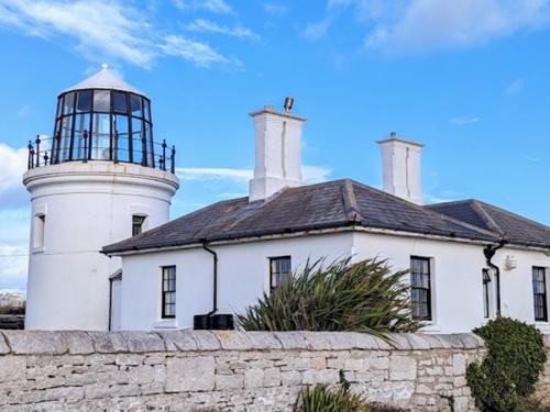
* Portland Bill (3) High
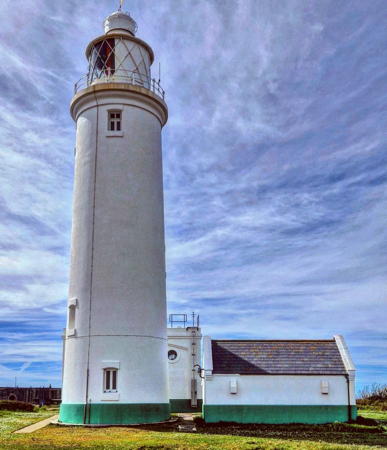
1869 (station established 1716). Inactive since 1906. Approx. 12 m (40 ft) round stone tower with lantern and gallery, painted white, attached to two 1-story keeper's houses. Additional 2-story keeper's residence. Bobbie Ville's 2023 photo is at right, Tony Weeks has a fine closeup, Peter Brookes has a 2017 photo, Mike Smith has a fine 2007 photo, and Google has a satellite view and a distant street view. After deactivation this lighthouse was sold as a private residence. After being vacant and deteriorating for 15 years the light station has recently been renovated for overnight accommodations. A new lantern (very different from the original) serves as an observation point. Located about 1 km (0.6 mi) north of the active lighthouse. Site open, tower closed except to paying guests. Owner/site manager: The Old Higher Lighthouse . ARLHS ENG-108.
**** Portland Bill (4)
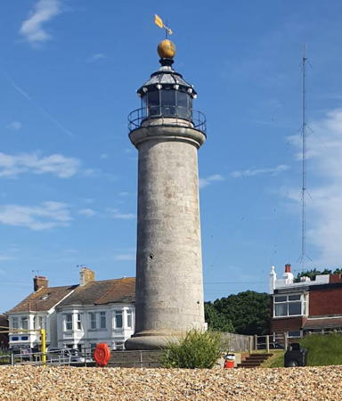
1906. Active; focal plane 43 m (141 ft); white flashes with a 20 s period, but the number of flashes varies with direction from one to four. 41.5 m (136 ft) round sandstone tower, painted white with a single broad red horizontal band, attached to a large 2-story keeper's house. Fog horn (blast every 30 s). An additional 2-story keeper's residence is occupied by a caretaker. Janet Comer's 2023 photo appears at the top of this page, Trabas has a closeup by Klaus Kern, Wikimedia has Wikimedia has David Howard's excellent 2005 photo and many additional photos, Huelse has a historic postcard view, Marinas.com has aerial photos, Buyruk Alparslan has a closeup street view, and Google has a 2021 street view and a satellite view. A 7 m (23 ft) triangular pyramidal stone obelisk (1844) is near the lighthouse at the extreme point of the cape; Wikimedia has Jim Champion's closeup photo and Tom Hewitt has a street view. The obelisk is in danger from erosion of the cliff; in 2002 Trinity House proposed to remove it but canceled its plans after public protests. In April 2015 Trinity House opened a Lighthouse Visitor Centre in the keeper's house. In October 2019 the rotating 1st order Fresnel lens was removed and replaced with a flashing LED system; after restoration the lens will be displayed in the base of the tower. Site open, tower open to guided tours on a variable schedule, every day (with a few exceptions) during the summer season and on weekends and selected additional dates the rest of the year. Parking provided; the light station is also accessible by buses from Weymouth. Operator: Trinity House. Site manager: The Crown Estate. ARLHS ENG-273; Admiralty A0294; NGA 0448.

1869 Portland Bill High Light, Portland, November 2023
Google Maps photo by Bobbie Ville

Information available on lost lighthouses:

Notable faux lighthouses:

Adjoining pages: East: Southeast England | West: Southwest England

Return to the Lighthouse Directory index | Ratings key

Posted August 9, 2004; checked and revised May 16, 2024. Lighthouses: 43; lightships: 3. Site copyright 2024 Russ Rowlett and the University of North Carolina at Chapel Hill.