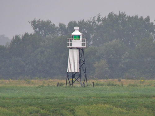
Lighthouses of the United Kingdom: Western England

The United Kingdom (officially the United Kingdom of Great Britain and Northern Ireland) includes England, Scotland, Wales, and Northern Ireland. England is the largest and most populous of the four, occupying more than 62% of the island of Great Britain and with a population of more than 56 million. Separated from the European mainland by the North Sea on the east and the English Channel on the south, it also has coasts facing the Celtic Sea on the southwest and the Irish Sea on the northwest.

Historically England was divided into 39 counties. The Directory pages are organized by the modern division of England into 48 "ceremonial" counties, also called lieutenancy areas because each one has a Lord Lieutenant representing the monarch in that area. For local government the ceremonial counties are subdivided in various ways into council areas.

This page lists lighthouses of the English west coast in the counties of Somerset, Bristol, and Gloucestershire. Lighthouses of the neighboring counties of Devon and Cornwall are listed on the Southwest England page.

These lighthouses guide vessels on the upper part of the Bristol Channel and its extension, the lower estuary of the River Severn. The city of Bristol lies on the River Avon to the south of the Severn but its deepwater port is at Avonmouth, where the Avon and Severn join. Small craft can also reach the port of Gloucester via the Severn and the Gloucester and Sharpness Canal.

The British system of lighthouse administration is decentralized, with the major towers under the management of Trinity House (a corporation chartered by the Crown) and smaller towers generally under the control of local port authorities. This system has generally assisted lighthouse preservation, and so has the British custom of building very sturdy stone lighthouses at most of the stations. Most of the onshore lighthouses are accessible to visitors and several of them are major tourist attractions.

ARLHS numbers are from the ARLHS World List of Lights. Admiralty numbers are from Volume A of the Admiralty List of Lights & Fog Signals. U.S. NGA numbers are from Publication 114.

General Sources
Photographers Resource - Lighthouses
A comprehensive guide to British lighthouses, with multiple photos and historical notes for many of the light stations.
Lighthouses of South West England
Photos and information from the Lighthouse Accomodations website.
Online List of Lights - England - Bristol Channel
Photos by various photographers posted by Alexander Trabas.
Leuchttürme in Grossbritannien
Photos by Andreas Köhler.
Lighthouses in England
Photos available from Wikimedia; many of these photos were first posted on Geograph.org.uk.
United Kingdom Lighthouses
Aerial photos posted by Marinas.com.
Trinity House
Chartered by Henry VIII in 1514, Trinity House has built and operated lighthouses in Britain for nearly 500 years.
Britische Leuchttürme auf historischen Postkarten
Historic postcard images posted by Klaus Huelse.
Association of Lighthouse Keepers
Founded by serving and retired keepers, this lighthouse association is open to everyone.
GPSNauticalCharts
Navigational chart information for the area.
Navionics Charts
Navigation chart for Bristol Channel and the Severn.

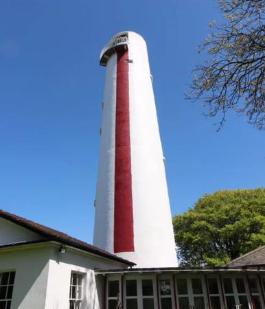
Burham-on-Sea High Light
Burnham-on-Sea High Light, July 2007
Geograph Creative Commons photo by Steve Fareham

Somerset Lighthouses

Somerset is located on the north side of the southwestern peninsula of England, facing the Bristol Channel east of the port of Bristol. It has a population just under one million. The two districts on the north side of the county have been unitary (independent) council areas since 1996 and on 1 April 2023 the four districts in the rest of the county were merged in the now-unitary Somerset Council area.

Western Somerset Lighthouses
* Watchet Harbour
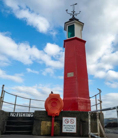
1862. Active; focal plane 9 m (30 ft); continuous green light. 6.5 m (22 ft) hexagonal cast iron tower with lantern. Tower painted orange red; lantern is white with a dark green roof. Leah Apple's 2024 photo is at right, Trabas has a photo by Klaus Kern, Nigel Chadwick has a 2010 photo, Wikimedia has photos, and Google has a satellite view and a closeup street view. Princess Anne attended ceremonies in September 2012 marking the 150th anniversary of the lighthouse. In early 2022 there was concern about deterioration of the lighthouse; a piece of the roof was blown off and the end of the pier was closed. Located at the the end of the breakwater on the west side of the harbor at Watchet; accessible by walking the breakwater. Site open, tower closed. Owner: Somerset Council. Operator/site manager: Watchet Marina. . ARLHS ENG-174; Admiralty A5584; NGA 6196.
Hinkley Point
Date unknown. Active; focal plane 7.5 m (25 ft); two continuous green lights, one above the other. Lights mounted on the water intake structure of the deactivated Hinkley Point Nuclear Power Station. Trabas has a photo and Google has a satellite view. Located about 600 m (3/8 mi) offshore from the power station, 10 km (6 mi) west of Burnham-on-Sea. Accessible only by boat. Site and tower closed. Admiralty A5582; NGA 6168.

Burnham-on-Sea Lighthouses
* Burnham-on-Sea Seafront Range Rear (St. Andrew's Church)
Date unknown. Active; focal plane 12 m (40 ft); continuous red light. 11 m (36 ft) square stone church tower. Trabas has a photo by Eckhard Meyer, Matt Johnson has a photo, and Google has a street view and a satellite view. The light is mounted on the tower of the St. Andrew's Church, a building that dates from 1315. The tower has a slight lean, centuries old, due to sinking foundations. The front light is on a lamppost-style mast. According to local historians a light was displayed from this church tower in the 1700s to guide local fishermen. In 1801 the light was moved to the Round Tower (next entry) and then in 1832 to the Trinity House range lights. Located just a few feet southwest of the Round Tower off the Esplanade in Burnham-on-Sea. Site open, tower closed. Owner/site manager: St. Andrew's Church. Admiralty A5572.1; NGA 6180.

Watchet Harbour Light, Watchet, March 2024
Instagram photo by Leah Apple
 
* Burnham-on-Sea (1) (Burnham Old, "Round Tower")
1801 (David Davies). Inactive since 1832. 2-story masonry tower with castellated top. Google has a satellite view. Originally four stories tall, the tower was reduced in height so that it would not be confused with the Burnham High Light. Built privately by the local curate, the lighthouse has always been known locally as the Round Tower. The building was converted to a guest house with overnight accommodations available. The guest house closed in 2022 when the owners announced their retirement. Located on the oceanfront Esplanade at Myrtle Drive in Burnham-on-Sea. Site open, tower closed. Owner/site manager: Round Tower Guest House . ARLHS ENG-323.
* Burnham-on-Sea (2) Low
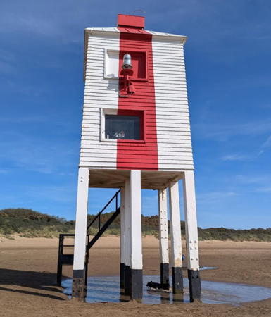
1832 (Joseph Nelson). Reactivated (inactive 1969-1996); focal plane 7 m (23 ft); white flash every 7.5 s; a directional light (white, red, or green depending on direction) is shown at a focal plane of 4 m (13 ft). 9 m (30 ft) square wooden tower with a conical roof mounted on 9 timber pilings. The tower has two windows, and as Sionéy Canning's photo at right shows the white light is mounted in front of the upper window and the directional light is inside the lower window. Lighthouse painted white with a single vertical red stripe on the front face. Tanya Dedyukhina's photo is at right, Trabas has a photo by Ian Wright, another good photo is available, Wikimedia has several photos, Huelse has a historic postcard view, Constantin Ciobanu has a street view from the beach, and Google has a satellite view. In April 2009 the district council announced plans to restore the historic stairway, which was removed in 1984 due to storm damage. The stairs were rebuilt in 2010 and the lighthouse was repainted. Chris McAuley's 2012 photo shows the stairway. The lighthouse was again repaired and repainted in 2016. Located on a broad beach about 1 km (0.6 mi) north of the center of Burnham-on-Sea. Site open, tower closed. Owner/operator: Somerset Council. . ARLHS ENG-019; Admiralty A5570; NGA 6172.
* Burnham-on-Sea (2) High ("Pillar Lighthouse")
1832. Inactive since 1996. 30 m (99 ft) brick tower with a conical roof and a half gallery on the front, incorporating keeper's quarters. Tower painted white with a red vertical stripe on the range line. Steve Fareham's photo is at the top of this page, Tony Denton's photo in Lighthouse Digest shows the red stripe, a 2022 photo is available, Wikimedia has several photos, Huelse has a historic postcard view, and Google has a street view and a satellite view. The tower remains in service as the rear beacon of a day range. Known locally as the Pillar Lighthouse, the building was sold as a private residence. In 1996 it was bought at auction by Patrick O'Hagan, who renovated the building and made it available for overnight accommodations. In May 2018 the lighthouse was listed for sale at £525,000. Located on Berrow Road just north of Stodden's Road in Burnham-on-Sea, about 500 m (0.4 mi) east of the low light. Site open, tower closed. Owner/site manager: private. ARLHS ENG-018.

Lower Light, Burnham-on-Sea, August 2022
Instagram photo by Sionéy Canning

North Somerset Lighthouses
* Blacknore Point
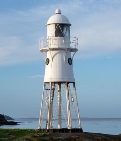
1894. Inactive since 2011. 11 m (36 ft) round, 6-legged cast iron tower with enclosed watch room, lantern and gallery, all painted white. 4th order Fresnel lens. Nigel Mundy's 2024 photo is at right, Kevin Cotterell has a lovely 2007 photo, Photographer's Resource has a page for the light, Wikimedia has several photos, Ian Knox has a 2017 photo, a 2022 photo is available, Marc Ward-Jenkins has a street view, and Google has a satellite view. An unusually well preserved late nineteenth century prefabricated lighthouse. In May 2010 Trinity House confirmed its intention to discontinue the light within the next few years, and the deactivation took place sometime early in 2011. Villagers created the Blacknore Lighthouse Trust to maintain the tower, and in January 2012 ownership was transferred to the trust. In November Trinity House returned the lens to the lighthouse after reaching a loan agreement with the Trust. The lighthouse was repainted in 2016 with contributed labor and materials. Located on the south shore of the Severn about 3 km (2 mi) west of Portishead; accessible by road or on the Somerset Coastal Path. Site open, tower closed. Owner/site manager: Blacknore Lighthouse Trust . ARLHS ENG-012; ex-Admiralty A5482; ex-NGA 6148.
* Portishead Point (Battery Point)
1931. Active; focal plane 9 m (30 ft); three quick white flashes every 10 s. 9 m (29 ft) square pyramidal skeletal tower with gallery, partially enclosed, mounted on a square concrete base. Tower painted black, contrasting with the white concrete of the base. Lighthouse connected to shore by an elevated walkway. Photographer's Resource has a page for the light, Trabas has a closeup photo by Arno Siering, Derek Harper has a 2010 photo, another photo is available, Wikimedia has several photos, a sunset 2022 photo is available, Marc Ward-Jenkins has a 2014 street view, and Google has a satellite view. Prefabricated by Chance Brothers, this light is the only surviving example of its type. For years the light was poorly maintained and rusting, but more recent photos show it to be repainted and restored. The fog bell formerly mounted on the front of the tower was donated to the town and is displayed in the median of Wyndham Way near High Street in downtown Portishead; Google has a street view. Located on a promontory just off Esplanade Road on the south shore of the Severn in Portishead, about 3 km (2 mi) west of the mouth of the Avon. Site open, tower closed. Operator: Bristol Port Company. . ARLHS ENG-106; Admiralty A5484; NGA 6144.

Blacknore Point Light, Portishead, February 2024
Instagram photo by Nigel J Mundy
Adam and Eve
Date unknown. Active; focal plane 8 m (26 ft); three quick green flashes every 6 s. 8 m (26 ft) mast atop a round stone tower. Tower painted white. Trabas has a closeup photo but overhanging trees on the river bank hide the light in Google's satellite view. Located on the south bank of the River Avon at a sharp bend in the Ham Green neighborhood. Difficult to access by land. Site open, tower closed. Admiralty A5512; NGA 6076.

Bristol Lighthouses

Bristol has been the leading port of western England since the 11th century. The city has a population of nearly 500,000; its center is on the River Avon about 12 km (7.5 mi) above its mouth, but the modern port facilities are at Avonmouth on the north side of the mouth of the river.

* Trinity House Lightship 55 John Sebastian
1886. Decommissioned 1953. 31.4 m (103 ft) wood lightship; the small lantern is atop a cylindrical mast amidships. Hull and mast painted red, superstructure white. Ian Yarde's photo is at right, Thomas Nugent has a photo, Linda Bailey has a good photo, and Google has a street view and a fine satellite view. This is the only surviving wooden lightship in Britain, if we except the wrecked Gull at Grays on the Thames. She served many stations, most recently the English and Welsh Grounds station in Bristol Channel (1939-1942 and 1947-1953). Sold for scrap, the ship was salvaged by breakers who removed most of the original equipment. Beached for burning, the ship was saved after nearby landowners objected. In 1954 she was purchased by the Cabot Cruising Club and since then she has been well maintained as the club's headquarters. The club has an article on the history of the lightship. The ship was under restoration in 2019. Moored at Bathurst Basin, on Commercial Road at Lower Guinea Street, just off the River Avon in Bristol. Site open, ship closed to non-members. Owner/site manager: Cabot Cruising Club. ARLHS ENG-322.

Lightship John Sebastian, Bristol, October 2019
photo copyright Ian Yarde; used by permission
Avonmouth South Pier
1907. Active; focal plane 9 m (30 ft); red or green light, depending on direction, one 3 s occultation every 30 s. 9 m (30 ft) granite tower with lantern and gallery. Tower unpainted, lantern painted white. Fog bell (stroke every 10 s). A closeup photo is at right, Trabas has a distant photo, Samsul Mehedi has a view of both pier lighthouses from the Severn, and Google has a satellite view. Located at the end of the pier on the south side of the entrance to the Avonmouth docks, but on the north side of the mouth of the River Avon. Site and tower closed; the pier is not open for walking. Visible at a distance. Operator: Bristol Port Company. ARLHS ENG-202; Admiralty A5492.21; NGA 6032.
Avonmouth North Pier
1908. Active; focal plane 15 m (50 ft); white flash every 4 s. 16 m (53 ft) granite tower with lantern and gallery. Tower unpainted, lantern painted white. Trabas has a good photo, Steve Fareham has a distant view, Samsul Mehedi has a view of both pier lighthouses from the Severn, and Google has a satellite view. Located at the end of the pier on the north side of of the entrance to the Avonmouth docks. Site and tower closed; the pier is not open for walking. Visible at a distance. Operator: Bristol Port Company. ARLHS ENG-003; Admiralty A5492; NGA 6024.
King Road Range Rear
Date unknown. Active; focal plane 15 m (49 ft); quick-flashing red light. 13 m (43 ft) skeletal tower with a small lantern and gallery, painted red; lantern painted white. Lightphotos.net has a photo, a distant view is available, and Google has a satellite view. This is the approach range for the Port of Bristol. The front light is on a small obelisk beside the North Pier lighthouse. Located 546 m (0.34 mi) north east of the front light. Site and tower closed. Admiralty A5494.1; NGA 6040.
 

Avonmouth South Pier Light, Bristol, February 2019
BBC News photo

Gloucestershire Lighthouses

The county of Gloucestershire includes the lower course of the River Severn as well as the historic Forest of Dean on the north side of the river. With a population of more than 900,000, the county is divided into seven districts. The South Gloucestershire District, adjoining the city of Bristol, has a unitary (independent) government. The rest of the county has two-tier government with a county council and six district councils.

South Gloucestershire District Lighthouse
* [Sheperdine (Shepperdine) Range Rear (3)]
2010 (station established 1886). Active; focal plane 13 m (43 ft); continuous white light. 12 m (39 ft) steel mast. Trabas has Köhler's photo and Google has a satellite view. The range guides vessels upstream on the Severn. The mast replaced the 1906 lighthouse, a 12 m (39 ft) square cast iron skeletal tower with lantern and gallery. The tower was painted black, lantern white; the tower also carried a vertically slatted white daymark under the gallery. The original light was on a wood post. Located on the south side of the Severn, off Nupdown Road in Shepperdine. This is an eastbound (inbound) range. The front light is in a square cabinet on a concrete post. Site open, tower closed. Operator: Gloucester Harbour Trustees. Admiralty A5549.1.

Stroud District (Severn South Shore) Lighthouses
[Fishing House Range Front (4)]
1985 (station established 1886). Active; focal plane 5 m (16 ft); continuous white light. 6 m (20 ft) round conical white fiberglass tower carrying an X-shaped daymark. Trabas has a photo, Mike Hartland has a photo, and Google has a street view and a satellite view. This is a westbound (outbound) range. The original light was replaced in 1894 and then by a skeletal tower in 1960. Located on the riverbank about 15 km (1 mi) southeast of Hamfields. Site status unknown. Operator: Gloucester Harbour Trustees. Admiralty A5552.
[Fishing House Range Rear (2)]
1985 (station established 1894). Active; focal plane 12 m (39 ft); continuous white light. 12 m (39 ft) mast carrying a vertically slatted daymark. Trabas has a photo and Google has a satellite view and a very distant street view. Located about 200 m (1/8 mi) southwest of the front light. Site and tower closed. Operator: Gloucester Harbour Trustees. Admiralty A5552.1.
* Berkeley Pill Range Front (2)
1937 (station established 1906). Active; focal plane 5 m (16 ft); continuous green light. 8 m (26 ft) square cast iron skeletal tower with lantern and gallery. Tower painted black, lantern white; the tower also carries a slatted white daymark under the gallery. Lewis Clarke's photo is at right, Trabas has a photo, Köhler has a photo, Robert Powell has a photo, and Google has a satellite view. This is a downstream (westbound) range. The original light was on a wood post. Note: "pill" is the English form of the Welsh word pwl, meaning an inlet or small harbor off a larger stream. Located on the south bank of the Severn in Hamfields, near Berkeley. Site appears closed, but the lighthouse can be seen from nearby. Operator: Gloucester Harbour Trustees. Admiralty A5556.

Berkeley Pill Range Front Light, Hamfields, July 2015
Geograph photo by Lewis Clarke
* Berkeley Pill Range Rear (2)
1937 (station established 1906). Active; focal plane 11 m (36 ft); continuous green light. 12 m (39 ft) square cast iron skeletal tower with lantern and gallery. Tower painted black, lantern white; the tower also carries a slatted white daymark under the gallery. Trabas has a photo, a photo of the two range lights is available, David Collins has a distant view, and Google has a satellite view. The original light was on a wood post. Located on the south side of the Severn, on Berkeley Pill in Hamfields, near Berkeley, about 175 m (190 yd) south of the front light. Site appears closed, but the lighthouse can be seen from nearby. Operator: Gloucester Harbour Trustees. Admiralty A5556.1.
Trinity House Lightship 23 Planet (ex-Mersey Harbour Board Lightship Bar)
1959 (Philips & Sons Ltd. of Dartmouth). Decommissioned 1989. 40.5 m (133 ft) two-masted steel lightship with light tower amidships, painted red. Barrie Mason has a 2011 photo of the ship at Liverpool, Eirian Evans has a 2009 photo, and an August 2011 photo is available. The ship served as the Bar off the entrance to the Mersey from 1960 to 1972, when it was sold to Trinity House and designated LV-23. After serving several locations she was assigned as the Channel from 1979 to 1989. She was the last manned lightship in U.K. waters. Saved from the scrapyard in 1992, the ship was docked for many years in Liverpool. The Mersey Light-Vessel Preservation Society tried to raise funds to buy and restore her, but in 2005 the ship was sold to a new owner, Gary McClarnan. The preservation society then closed its operations. McClarnan had the ship painted and berthed it in Liverpool at the Canning Half Tide Dock. In 2008 McClarnan placed the ship for sale for £139,000 and it was sold to Alan Roberts. Restored and repainted, the ship reopened in 2011 as a café and bar; it was also available for hire for special events. In 2016 Roberts launched a fundraising drive to raise £10,000 for unpaid past and future berthing fees. Apparently this effort failed and in September 2016 the Canal and River Trust seized the ship and towed it to a storage location at the Sharpness Docks. Ian Yarde's photo of the ship at Sharpness is at right and the Lighthouse Accommodations page for the ship shows it at that location. The Trust put the ship up for sale to settle its debts while preservationists petitioned for its return. In early 2017 the Trust announced that the ship had been sold, but apparently this sale collapsed. In 2018 Roberts was bringing a suit against the Trust for theft of the vessel. Phil Oates has a photo of the ship still at Sharpness in November 2021. Moored at Sharpness Docks in Sharpness; Google has a satellite view. Site and tower closed. Owner: private. Site manager: Sharpness Shipyard and Drydock. ARLHS ENG-065.

Gloucester City Lightship
** Humber Conservancy Board Lightship 14 Sula (Spurn, Beaucette, Conwy, Haven)
1959 (Cook, Welton and Gemmell, Beverley, Yorkshire). Decommissioned 1985. 34.75 m (114 ft) steel lightship; round skeletal light tower with lantern and gallery amidships. Entire vessel painted red. A 2023 photo is at right, Chris Allen has a July 2011 photo, Heather Craven contributed a 2019 photo, a 2023 photo is available, and Google has a September 2013 closeup street view and a satellite view. The ship served its entire career in the North Sea on the Spurn station, where it replaced Lightship 12 (now at the Hull Marina in downtown Hull). Sold in 1987, it became the Beaucette, the club ship of the Beaucette Yacht Club in Guernsey, Channel Islands. In 1989 the marina owners moved it to their marina at Conwy, in North Wales, where it was known briefly as the Conwy. In 1990 it was sold to the Milford Haven Port Authority in South Wales. Renamed Haven, it was moored at the Milford Marina as a tourist attraction. In 1997 it was sold to English investors who planned to use the vessel as an adventure center at Bantry in the south of Ireland. These plans did not bear fruit and for most of the next decade the ship was moored off Bear Island at Castletownbere, County Cork. Trevor O'Hanlon has a 2004 photo of the ship in Ireland. The ship was moved to a scrapyard in Waterford later in 2004 but it was not scrapped. In June 2007 it was sold to new owners, Jan and Agnes van der Elsen, who planned to use it as an alternative healing center at Gloucester. In November it was towed across the Irish Sea to Sharpness Shipyard, near Gloucester, for restoration and renovation. In March 2010 the ship was renamed Sula. By the fall of 2010 the renovation was complete and the necessary permits to moor the ship at Llanthony Quay in Gloucester had been approved. Ceremonies opening the vessel were held in December 2010. Doing business as Lightship Therapies, the ship offered holistic therapy and Buddhist meditation sessions. Gloucester Docks has a page created for the ship in this period. In April 2015 the Van der Elsens closed this business and placed the ship for sale at £575,000. City officials were hopeful that a buyer could be found to keep the ship at its current location, perhaps as a restaurant. As of September 2017 the ship was still for sale at the reduced price of £450,000; a portfolio of photos is available. In early 2018 the price was again reduced to £395,000. In July 2019 the Van der Elsens announced that they had a sale. The new owners renovated the ship to be a bed and breakfast and began accepting bookings in May 2022. Located on the west side of the canal between Llanthony Road and St. Ann's Way in downtown Gloucester. Site and vessel closed. Owner: LV Sula .

Forest of Dean District (Severn North Shore) Lighthouses
Trinity House Lightship 14 Helwick
1953. Decommissioned 1991. 36.3 m (119 ft) steel lightship; hexagonal skeletal light tower with lantern and gallery amidships. Ship painted red; lantern dome painted white. Eirian Evans has a 2008 photo. First assigned to the Kentish Knock station, the ship served many stations over its career, ending as the Helwick off the Gower coast from 1984 through 1989. In 1993, as Lightship 2000, the ship became a Christian fellowship center moored near the Cardiff Bay Visitor Centre in Cardiff Bay, Wales. Wikipedia has a photo of the ship near the end of this period. In early 2015 the ship was sold for a nominal amount and in May it was towed upriver to Newnham-on-Severn, Gloucestershire, about 16 km (10 mi) southwest of Gloucester. It was to become a "floating museum," but no information on the museum plans is available. In November 2015 the ship was moored a short distance downstream from Newnham; Google's more recent satellite view shows that the ship has been beached. Heather Craven's 2019 photo is at right. Current information is needed. ARLHS WAL-059.


Lightship 23 Bar, Sharpness, October 2019
photo copyright Ian Yarde; used by permission
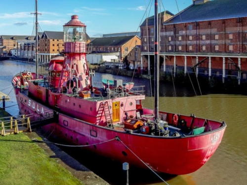

Lightship Sula, Gloucester, April 2023
Google Maps photo by LV14 Sula Lightship
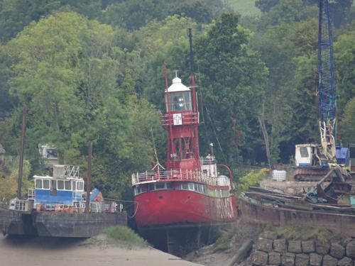

Lightship 14 Helwick, Newnham-on-Severn, October 2019
photo copyright Heather Craven; used by permission

 
Inward Rocks Range Front (3)
1985 (station established 1886). Active; focal plane 6 m (20 ft); continuous white light. 6 m (20 ft) round barbell-shaped white fiberglass tower with an orange daymark at the top. Trabas has a photo and Google has a satellite view. This is a westbound (outbound) range. The original light was replaced by a skeletal tower in 1907. Located on a prominent point about 4 km (2.5 mi) northeast of the older Severn Bridge. Site and tower closed. Operator: Gloucester Harbour Trustees. Admiralty A5548.
[Inward Rocks Range Rear (3)]
1985 (station established 1886). Active; focal plane 23 m (75 ft); continuous white light. Approx. 20 m (66 ft) mast carrying two rectangular orange and white checkered daymarks. Trabas has a photo showing different daymarks and Google has a satellite view. Located in a farm field about 400 m (1/4 mi) southeast of the front light. Site and tower closed. Operator: Gloucester Harbour Trustees. Admiralty A5548.1.
Slime Road Range Rear (2)
1941 (station established 1914). Active; focal plane 16 m (52 ft); continuous blue light. 8 m (26 ft) square cast iron skeletal tower with lantern, gallery, and a rectangular vertically-slatted daymark. The lantern is not in use; the light is provided by vertical neon tubes mounted on the front of the lantern. Tower painted black; lantern, gallery rail, and daymark painted white. Heather Craven's photo is at right, Trabas has a photo and Google has a street view and a satellite view. This is a westbound (outbound) range. The front light has similar neon tubes in a small cabinet. Located just inside the gate of a British Army base. Site and tower closed, but the light can be seen from Beachey Road. Operator: Gloucester Harbour Trustees. Site manager: First Battalion The Rifles. Admiralty A5547.1.
Lyde Rock (3)
2008 (station established 1896). Active; focal plane 12 m (39 ft); quick-flashing light, white or red depending on direction. 12 m (39 ft) square cast iron skeletal tower with gallery. Tower painted black with three white horizontal bands. Chris Gunns has a 2009 photo, Trabas has Arno Siering's photo, and Google has a street view and a satellite view. The 1896 lighthouse was destroyed in a collision with a ship. Ruth Sharville has a 2007 photo of the second (1941) light. Located on a submerged rock on the north side of the Severn off Beachley, about 300 m (0.2 mi) upstream from the older Severn Bridge. Accessible only by boat. Site open, tower closed. Operator: Gloucester Harbour Trustees. Admiralty A5545.

Slime Road Range Rear Light, Beachley, October 2019
photo copyright Heather Craven; used by permission
[Chapel Rock (3)]
2010 (station established 1886). Active; focal plane 6 m (20 ft); flash every 2.6 s, white, red or green depending on direction. 8 m (26 ft) triangular skeletal mast. Trabas has Andreas Köhler's photo, Rene Schoeters has a 2017 photo, and Google has a satellite view. This light replaced a square cast iron skeletal tower with gallery; Roy Parkhouse has a photo. It had been removed at the time of Google's 2009 street view. The original lighthouse was a wood skeletal tower; it was replaced by a steel skeletal tower in 1907. Located on a rocky shoal off Beachley, on the north side of the Severn, about 650 m (0.4 mi) downstream from the older Severn Bridge (M-48). Accessible only by boat. Site open, tower closed. Operator: Gloucester Harbour Trustees. Admiralty A5541; NGA 5994.

Information available on lost lighthouses:

Notable faux lighthouses:

Adjoining pages: South: Southwestern England | West: Wales

Return to the Lighthouse Directory index | Ratings key

Posted November 23, 2004. Checked and revised June 1, 2024. Lighthouses: 17; lightships: 4. Site copyright 2024 Russ Rowlett and the University of North Carolina at Chapel Hill.