Lighthouses of the United Kingdom: Wales

The United Kingdom (officially the United Kingdom of Great Britain and Northern Ireland) includes England, Scotland, Wales, and Northern Ireland. Wales (Cymru in Welsh) occupies a mountainous peninsula to the west of England, surrounded by water on three sides, the Bristol Channel to the south, the Celtic Sea to the southwest and the Irish Sea to the west and north. A country with a distinct Celtic heritage and language, Wales was conquered by England in the 13th century and formally annexed to England in the 16th century. Since 1301 the title Prince of Wales has been held traditionally by the heir to the English and later British throne.

Most of the coastline of Wales is rugged, scenic, and hazardous to navigation. The lighthouses of the country are clustered in the north, guarding the approaches to the Mersey estuary and the port of Liverpool, and in the south, guarding the approaches to the Severn. estuary and the port of Bristol. The largest number of lighthouses can be found at the northwestern corner on the Isle of Anglesey and at the southwestern corner in Pembrokeshire.

Historically divided into 13 counties, Wales is now divided into 22 council areas, known as principal areas, some styled as counties, some as county boroughs, and some as cities. Sir is the Welsh word for county, corresponding to the English shire.

The Welsh language Cymraeg is spoken commonly in many parts of Wales, especially the north and west. The Welsh word for a lighthouse is goleudy; ynys is an island, trywn is a cape, pen is a headland, culfor is a strait, aber is an estuary, afon is a river, and porthladd is a port.

The major coastal lighthouses are maintained by Trinity House, the English lighthouse administration. Several, including South Stack, St. Ann's Head, and Nash Point, are among the best known and most visited British lighthouses. Harbor lights are under the control of local port authorities.

ARLHS numbers are from the ARLHS World List of Lights. Admiralty numbers are from Volume A of the Admiralty List of Lights & Fog Signals. U.S. NGA numbers are from Publication 114.

General Sources
Trinity House
Chartered by Henry VIII in 1514, Trinity House has built and operated lighthouses in Britain for nearly 500 years.
Lighthouses of South Wales and North Wales
Photos and information from the Lighthouse Accomodations website.
Online List of Lights - Wales and Bristol Channel
Photos by various photographers posted by Alexander Trabas.
Lighthouses in Wales
Photos by various photographers available from Wikimedia.
World of Lighthouses - Wales
Photos by various photographers available from Lightphotos.net.
United Kingdom Lighthouses
Aerial photos posted by Marinas.com.
Association of Lighthouse Keepers
Founded by serving and retired keepers, this lighthouse association is open to everyone.
Britische Leuchttürme auf historischen Postkarten
Historic postcard images posted by Klaus Huelse.
GPSNauticalCharts
Navigational chart for Wales.
Navionics Charts
Navigational chart for Wales.


Trwyn Du (Penmon Point) Light, Penmon, June 2023
Google Maps photo by David Cumbley
Lighthouses of South Wales

Monmouthshire (Sir Fynwy) Lighthouses
The principal area of Monmouthshire, in the southeastern corner of Wales, includes the mostly rural eastern 3/5 of the historic county of the same name. The county has a population of a little less than 100,000 and a short coast facing the Severn Estuary.

Redcliffe Range Front
1883. Active; focal plane 16 m (52 ft); continuous blue light. 10 m (33 ft) square cast iron skeletal tower with lantern, gallery, and a rectangular vertically slatted white daymark below the gallery. The lantern is not in use; the light is provided by eight vertical neon tubes mounted on the daymark. Tower painted black, lantern white. Heather Craven's photo is at right, Trabas has a closeup photo, Steve Fareham has a photo, and Google has a good satellite view. Originally this was the rear light of a range having the Charston Rock Light as the front light. The rear light of the modern range is on a pole 320 m (1000 ft) north of the lighthouse. Located on the north bank of the Severn about 2.5 km (1.5 mi) southwest of Bulwark. Site status unknown. Operator: Gloucester Harbour Trustees. Admiralty A5536; NGA 5988.
Charston Rock (Black Rock)
1868. Active; focal plane 5 m (16 ft); white flash every 3 s. 7 m (23 ft) round brick tower with lantern and gallery, painted white with a vertical black stripe. Trabas has a photo, Steve Fareham also has a good photo, Richard Thomas has a 2022 drone view, and Google has a satellite view. This light is still in the line of the Redcliffe Range. Located on a small island off the north shore of the Severn just east of Portskewett. Accessible only by boat; visible from a hiking trail along the river. Site and tower closed. Operator: Gloucester Harbour Trustees. ARLHS WAL-044; Admiralty A5535; NGA 5984.

Redcliffe Range Front Light, Bulwark, October 2019
photo copyright Heather Craven; used by permission

Newport (Casnewydd) Lighthouses
Newport is a city and county borough of about 150,000 residents located on the River Usk in the southeastern corner of Wales. The harbor includes the Alexandra Docks, a basin entered through a tidal lock.

* [Gold Cliff]
1924. Inactive; charted as a landmark. 9 m (29 ft) square cylindrical cast iron tower painted white; no lantern. Robin Drayton has a fine closeup, Neil Brown has a closeup street view, and Google has a satellite view. An old and interesting minor aid to navigation, endangered by age and rust. Located on a promontory about 2 km (1.2 mi) south of Whitson. Site open, tower closed. Owner: unknown. ARLHS WAL-056.
* East Usk
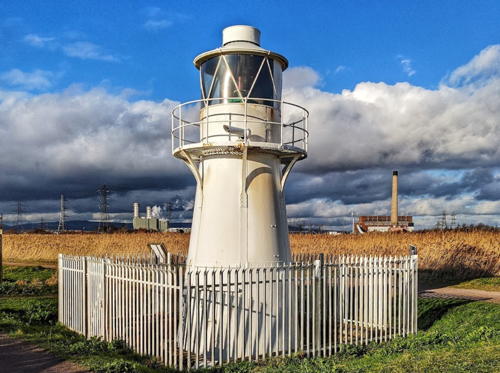
1893. Active; focal plane 11 m (36 ft); two flashes every 10 s, white, red, or green depending on direction. Approx. 11 m (36 ft) round cast iron tower with lantern and gallery, painted white. Matthew James has the 2020 photo seen at right, Robin Drayton has a photo, Trabas has a fine photo, a 2023 photo is available, Marinas.com has aerial photos, and Google has a street view and a satellite view. This is a leading light for the approach to Newport. Located on the east side of the entrance to the River Usk about 2 km (1.2 mi) southwest of Nash. Accessible by a walk of about 2 km (1.25 mi) from the Newport Wetlands Carpark. Site open, tower closed. Operator: Newport Harbour Commissioners. Site manager: Newport Wetlands Nature Preserve. . ARLHS WAL-005; Admiralty A5454; NGA 5904.
Alexandra Docks East Pier
Date unknown. Active; focal plane 9 m (30 ft); two continuous green lights, one above the other. 6 m (20 ft) square white skeletal tower. Trabas has a photo and Google has a satellite view. Located on the curving east pier at the entrance to the tidal lock. Site and tower closed. Operator: Newport Harbour Commissioners. Admiralty A5462; NGA 5912.

East Usk Light, Nash, January 2020
Google Maps photo by Matthew James
Alexandra Docks West Pier
Date unknown. Active; focal plane 9 m (30 ft); two continuous red lights, one above the other. 6 m (20 ft) square white skeletal tower. Trabas has a photo and Google has a satellite view. Located on the curving west pier at the entrance to the tidal lock. Site and tower closed. Operator: Newport Harbour Commissioners. Admiralty A5460; NGA 5908.
** West Usk
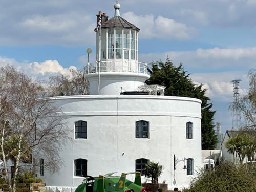
1821 (James Walker). Inactive officially since 1922 but an unofficial white light is often displayed; charted as a landmark. 17 m (56 ft) round cylindrical brick tower with lantern and gallery rising from the center of a round 2-story brick keeper's house. Building painted white; lantern roof is black. Stacey Peart's 2023 photo is at right, another good photo is available, Stephen James has a closeup, a December 2021 photo shows the lighthouse in action, Huelse has a historic postcard view, and Google has a satellite view. This is the first of the 22 lighthouses built by the Scottish engineer James Walker; its unusual design makes it an architectural landmark. Frank Sheahan and his wife Danielle bought the lighthouse in 1987 and renovated it as a bed and breakfast. In 2006, seeking to retire, the Sheahans advertised the lighthouse for sale for £1 million. It did not sell. They put the property back on the market in 2018, now asking £1.75 million. At last report (June 2024) it had still not sold and the Sheahans are now operating the building as a site for weddings and other special events with overnight accommodations in a cabin nearby. Located on the west side of the entrance to the River Usk off the B4239 (Lighthouse Road) about 6 km (4 mi) south of Newport. Site open, lighthouse open only to event guests. Owner/site manager: West Usk Lighthouse . ARLHS WAL-032.
 

West Usk Light, Newport, April 2023
Google Maps photo by Stacey Peart

Cardiff (Caerdydd) Lighthouses
The City and County of Cardiff is the capital and largest city of Wales, with a population of about 375,000. Its port, the Cardiff Docks, was once a major port for the export of coal from South Wales mines; it is less active but much more diversified today.
* Cardiff Outer Harbor North Arm
Date unknown. Active; focal plane 9 m (30 ft); green flash every 10 s. 5.5 m (18 ft) round hourglass-shaped green fiberglass tower. A signal mast stands next to the tower. Trabas has a photo and Google has a satellite view and a closeup street view. Located at the end of the outer breakwater of the south harbor. Accessible by walking the pier from the Cardiff Barrage; some limited parking is available at the entrance. Site open, tower closed. Operator: Cardiff Harbour Authority. Admiralty A5444.31.
Monkstone
1839 (unlit until 1925). Active; focal plane about 21 m (69 ft); white flash every 5 s. 23 m (75 ft) tower: the original 14 m (45 ft) stone tower with gallery, topped by a 9 m (30 ft) round cylindrical red fiberglass tower with its own small lantern and gallery. The stone tower is strengthened by vertical and horizontal wrought iron bands, which are painted red. Photographer's Resource has a page with a closeup, Lighthouse Accommodations also has a page for the lighthouse, Lighthouse Digest has Tony Denton's closeup photo, Rene Schoeters has a 2017 closeup photo, and Trabas has Andreas Köhler's foggy photo. The lighthouse is built on an underwater rock. A light on a cast iron skeletal tower was mounted on the stone base in 1925, and the fiberglass section replaced the cast iron section in 1993. Located about 5 km (3 mi) east northeast of Lavernock Point and 8 km (5 mi) south of Cardiff. Accessible only by boat. Site and tower closed. Operator: Trinity House. ARLHS WAL-043; Admiralty A5428; NGA 5864.
Flat Holm (Flatholm, Ynys Echni)
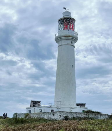
1737 (William Crispe and Benjamin Lund; substantially altered in 1820). Active; focal plane 50 m (164 ft); three flashes, white or red depending on direction, every 10 s. 30 m (99 ft) round stone tower with lantern and gallery, attached to 1-story keeper's house. 1-story fog signal building with two giant fog horns. A photo by Alan Hughes is at right, Lighthouse Accommodations has a page for the lighthouse, Wikimedia has several photos, Trabas has Andreas Köhler's distant view, Marinas.com has aerial photos, Huelse has a historic postcard view, and Google has a satellite view. Trinity House rebuilt the privately-built lighthouse after leasing it in 1819; essentially a new tower was wrapped around the old one. The tower was altered further in 1867 to support a first-order lantern. The foghorn (1908), deactivated in 1988, has been restored to working condition and is sounded on special occasions. Trinity House repaired and repainted the light tower in the fall of 2017. Flat Holm is a small island in the middle of the entrance to the Severn estuary from the Bristol Channel. The island is a historical and natural reserve. The Flat Holm Project is restoring the buildings and the ecosystem of the island; the Flat Holm Society has been formed to support the project. Tours of the island depart from Cardiff and Barry on most days during the warmer months. Located on the south side of the island. Site open, tower closed. Operator: Trinity House. . ARLHS WAL-006; Admiralty A5426; NGA 5860.

Flat Holm Light, Cardiff, August 2018
Wikimedia Creative Commons photo by Alan Hughes

Vale of Glamorgan (Bro Morgannwg) Lighthouses
The County Borough of the Vale of Glamorgan (The Vale for short) occupies the southernmost stretch of the Welsh coast facing the Bristol Channel. Barry is the largest town and only port. The county's population is about 140,000.

Barry (Y Barri) Docks West Breakwater
1890. Active; focal plane 12 m (40 ft); one quick white flash every 2.5 s. 9 m (30 ft) round cast iron tower with lantern and gallery, painted white; lantern dome painted red. Trabas has Eckhard Meyer's photo, Andrew Jeffery has a 2022 photo, another good photo is available, and Google has a satellite view and a distant street view. Located at the end of the west breakwater at Barry, about 15 km (9 mi) southwest of Cardiff. The pier is gated. Site and tower closed. Operator: Port of Barry. ARLHS WAL-034; Admiralty A5412; NGA 5836.
Breaksea Point
Date unknown. Active (privately maintained); focal plane 11 m (36 ft); flashing red light. 11 m (36 m) round domed water intake structure; the light is atop the dome. Trabas has Eckhard Meyer's photo and Google has a satellite view and a very distant street view. Breaksea Point, the southernmost point of the Welsh mainland, is the site of the decommissioned Aberthaw Power Station, a large plant formerly fueled by coal and biomass. Located about 300 m (1000 ft) off the point. Accessible only by boat. Admiralty A5407; NGA 5824.
* Nash Point (High)
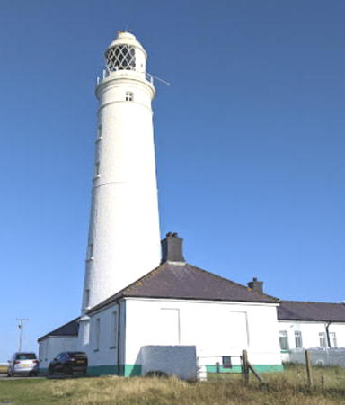
1832 (James Walker). Active; focal plane 56 m (154 ft); two white or red flashes, depending on direction, separated by 3.7 s, every 15 s. 37 m (122 ft) round stone tower with gallery attached to 1-story keeper's house. 1-story masonry fog signal building (inactive) topped by a large double diaphone horn. Entire station painted white. The two keeper's houses are available for vacation rental. Eleri David's 2021 photo is at right, Trabas has a photo, Lighthouse Accommodations has a page for the light station, Wikimedia has many photos, Peter Wasp has a fine 2006 photo, Marinas.com has aerial photos, Robert Plant has a street view, and Google has a satellite view. Huelse's postcard view shows the lighthouse painted with black and white horizontal bands. Nash Point marks the entrance to the narrower part of the Bristol Channel leading to the major ports of Cardiff and Bristol. The lighthouses were built after the paddlewheel steamer Frolic wrecked nearby with heavy loss of life in December 1830. Originally this light and the low light formed a range for ships entering Bristol Channel. Through 2018 tours of the lighthouse were offered under license by a group organized by a former attendant. In 2019 Trinity House ended this arrangement and took full control of the site. Located about 5 km (3 mi) west of Llanwit Major near St. Donat's. Accessible by road or by walking the coastal path from St. Donat's. Site open, tower closed. Operator/site manager: Trinity House. . ARLHS WAL-017; Admiralty A5406; NGA 5816.
* Nash Point Low
1832 (James Walker). Inactive since the early 1920s. 20 m (67 ft) round stone tower with gallery attached to 1-story keeper's house. Lantern removed. Entire station painted white. The two keeper's houses are available for vacation rental. Peter Wasp has a good photo, Gibbs Burke is a 2017 photo, Huelse has a historic postcard view showing the lantern, and Google has a street view and a satellite view. Located about 5 km (3 mi) west of Llanwit Major, near St. Donat's. Accessible by road or by walking the coastal path from St. Donat's. Site open, tower closed. Owner/site manager: Trinity House. ARLHS WAL-037.

Nash Point High Light, St. Donat's, August 2021
Google Maps photo by Eleri David

Bridgend (Pen-y-bont ar Ogwr) Lighthouse
The County Borough of Bridgend has only a short coastline at the seaside resort of Porthcawl. The borough has a population of about 140,000.
* Porthcawl Breakwater
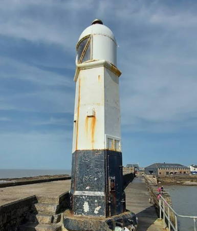
1860. Active; focal plane 10 m (34 ft); continuous light, white over the entrance channel and red or green to the sides. 9 m (30 ft) hexagonal cast iron tower with domed lantern, painted white with a black band around the base. A 2021 photo by Michal Mertensis at right, Trabas has a closeup photo by Arno Siering, Rene Schoeters has a closeup, a September 2006 closeup is available, Marinas.com has aerial photos, Huelse has a historic postcard view, and Google has a satellite view and a distant street view. This is one of the only two surviving cast-iron lighthouses in Wales. Long powered by gas, the little lighthouse was not converted to electric power until 1997. Located at the end of the breakwater on Porthcawl Point in Porthcawl, at the eastern entrance to Swansea Bay. Accessible by walking the breakwater. Site open, tower closed. Operator: Bridgend County Borough Council. . ARLHS WAL-036; Admiralty A5402; NGA 5812.

Neath Port Talbot (Castell-nedd Port Talbot) Lighthouses
The County Borough of Neath Port Talbot is immediately to the east of Swansea and faces southwest on Swansea Bay. Port Talbot is an industrial port importing coal and iron ore for a large steel plant.

Port Talbot (Aberafan) Range Front
Date unknown. Active; focal plane 12 m (30 ft); red light, 2 s on, 1 s off. 12 m (39 ft) square steel skeletal tower with gallery. The light is shown through the center of a diamond-shaped slatted daymark. Lighthouse and daymark painted a dull orange. Trabas has a photo, Brian Painter has a distant view, and the shadow of the light is seen in Google's satellite view. Located next to the port authority building on the south side of the entrance to the River Afan. Site and tower closed. Admiralty A5391; NGA 5800.
Port Talbot (Aberafan) Range Rear
Date unknown. Active; focal plane 32 m (105 ft); red light, 5 s on, 1 s off. 30 m (98 ft) square steel skeletal tower with gallery. The light is shown through the center of a diamond-shaped slatted daymark. Lighthouse and daymark painted a dull orange. Trabas has a photo and Google has a satellite view. The tower stands next to a lock that admits large ships carrying iron ore to an inner harbor serving a large Tata Steel plant. Located in an industrial zone on the east side of Port Talbot, on the south side of the mouth of the River Afan. Site and tower closed, although there should be a good view from the end of Riverside Drive. Admiralty A5391.1; NGA 5804.

Porthcawl Breakwater Light, Portcawl, March 2021
Google Maps photo by Michal Mertensis
Trinity House Lightship 72 Juno
1903 (John Crown and Sons, Sunderland). Decommissioned 1973. 35.4 m (116 ft) steel lightship with light tower, lantern and gallery. Phil Jones has a photo, Alun Rhydderch has a 2021 photo, and Google has a satellite view. Endangered. The ship served various stations but it is best known for its service in the D-Day invasion of 6 June 1944, when it marked a mine-cleared channel for the invasion armada. At that time it carried the name Juno, the code name of one of the major D-Day beaches. After deactivation the ship was sold to the Steel Supply Company for scrap. However, the company decided not to scrap the vessel. It was maintained for a time as an office; later a plan to convert it to use as a night club failed. The ship is now derelict and detriorating. In October 2016 Daniel Broom, a World War II amateur historian, launched an effort to save the vessel as a D-Day memorial. Meanwhile a group called Save Our Ship of Light was organized with the idea of returning the ship to Sunderland. Located on the west bank of the River Neath below Neath, about 15 km (9 mi) north of Port Talbot. Site and vessel closed. Owner/site manager: Sims Metal Management.

Swansea (Abertawe) Lighthouses
The City and County of Swansea is the second largest city of Wales with a county population of about 250,000. The city was known in the 19th century for copper smelting, but in the 20th century heavy industry declined and the city now serves more as the cultural and service center for South Wales.

*
Trinity House Lightship 91 Helwick (Humber)
1937. Decommissioned 1977; a decorative light is often displayed. 31.7 m (104 ft) steel lightship, painted red; hexagonal skeletal light tower with lantern and gallery amidships. A fine September 2007 photo is available, Wikimedia has a photo by James Petts, Colin Park has a photo, Lighthouse Accommodations has a page with photos, and Google has a closeup street view and a good satellite view. The ship served most of its career on the Humber station, where it was damaged twice in collisions with other vessels. It was moved to the Helwick station in 1971. When it was decommissioned in 1977 it was donated to the city of Swansea. Moored at the Victoria Quay on the waterfront in Swansea. Site open, vessel closed. Owner/site manager: Swansea Museum. . ARLHS WAL-052.
* Mumbles
1794 (William Jernegan). Active; focal plane 35 m (114 ft); four white flashes, separated by 2.2 s, every 20 s. 17 m (56 ft) round two-stage octagonal cylindrical brick tower with lantern and double gallery, painted white; twin 300 mm lenses. A 1st order Fresnel lens from this lighthouse is on display at the Swansea Museum. Twin 2-story keeper's houses. Simon Aspell's 2023 photo is at right, Lighthouse Accommodations has a page for the lighthouse, Trabas has a photo, Scott Dexter has a photo, Mick Lobb has a photo, a good view from the sea is available, Wikimedia has several photos, Marinas.com has aerial photos, Huelse has a historic postcard view, and Google has a street view and a satellite view. Built by the Swansea Harbour Board, the lighthouse was designed in two stages so that coal fires could be displayed at two levels. Trinity House took control of the light from the British Transport Docks Board in 1975. In 2018 the lighthose was renovated and an LED optic was installed. The lighthouse is built on a small island which is accessible, with caution, at low tide. Located just off Mumbles Head, marking the entrance to Swansea Bay. Parking provided at the end of the A4067 highway about 12 km (7.5 mi) south of Swansea. Site open, tower closed. Operator: Trinity House. . ARLHS WAL-016; Admiralty A5358; NGA 5756.

Mumbles Light, Swansea, August 2023
Google Maps photo by Simon Aspell

Carmarthenshire (Sir Gâr) Lighthouse
The County of Carmarthenshire is the third largest principal area of Wales, occupying a large part of the southwest of the country. Mostly rural, it has a population of about 190,000.
Whiteford (Whitford) Point (2)
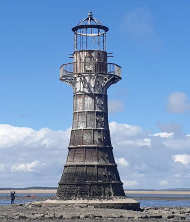
1865 (station established 1854). Inactive since 1926. 13.5 m (44 ft) round tapered cast iron tower with lantern and gallery. That's what it was originally, but after being abandoned more than half its life the lighthouse is near collapse. This is one of the UK's most endangered lighthouses. Taffy McTaffs's photo is at right, Lighthouse Accommodations has a page for the lighthouse, Wikimedia has several good photos, Ayaaz Ashraf has a 2017 closeup photo, Lorcan O'Connell has a 2022 photo, and Google has a satellite view. In 2000 the lighthouse was offered for sale for £1. An agreement is said to have been reached to restore the tower but apparently this agreement collapsed. The tower is once again for sale for £1 but buyers must prove they have £200,000 available for restoration. Chris Tagg visited the site in March 2005 and reports the lighthouse "strikes a sorry figure, although does not look in danger of falling down," since the cast iron is lined with brick or stone. Located on Whitford Point, on the south side of the Loughor Estuary opposite Burry Port. Walking to this site requires a long hike across the Whiteford Sands, and Tagg says the lighthouse is "surrounded by treacherous and deadly currents and shifting sands." Owner/site manager: Carmarthenshire County Council. . ARLHS WAL-033.
* Burry Port (Porth Tywyn)
1842. Active; focal plane 7 m (24 ft); white flash every 5 s. 6 m (19 ft) broad round cylindrical brick tower with lantern and gallery. Tower painted white with black trim, lantern red. Trabas has a photo, Wikimedia has several photos, Wayne Wilkins has a 2022 photo, Ian Busby has a 2022 drone view, Huelse has a historic postcard view, and Google has a distant street view and a satellite view. The lighthouse was restored in 1995-96 by Llanelli Borough with the support of the Burry Port Yacht Club. Located on the breakwater at the harbor entrance at Burry Port on the north side of the Loughor Estuary. Site open, tower closed. Operator: Carmarthenshire County Council. . ARLHS WAL-035; Admiralty A5356; NGA 5748.

Whiteford Point Light, Llanelli, October 2020
Google Maps photo by Taffy McTaffs

Southern Pembrokeshire (Sir Benfro) Lighthouses
The County of Pembrokeshire occupies a peninsula at the southwestern corner of Wales. Most of its scenic coastline is protected by the Pembrokeshire Coast National Park. Near the tip of the peninsula the coast is interrupted by the Milford Haven Waterway, an estuary that forms a magnificent natural harbor. The population of the county is about 125,000.

*
Saundersfoot South Pier
1848. Active; focal plane 6.5 m (21 ft); red flash every 5 s. 5 m (17 ft) round cylindrical rubblestone tower with domed roof. Formerly shone through a window, the light is now mounted atop the dome. Trabas has Eckhard Meyer's photo, Peter Lawson has another closeup photo, Hywel Edwards has a street view, and Google has a satellite view. Located on the pierhead in Saundersfoot. Site open, tower closed. Operator: Saundersfoot Harbour Commission. ARLHS WAL-048; Admiralty A5342; NGA 5744.
* Caldey Island (Ynys Byr)
1829 (Joseph Nelson). Active; focal plane 65 m (314 ft); three flashes, white or red depending on direction, every 20 s. 16 m (52 ft) round brick tower with lantern and gallery attached to two 2-story keeper's houses. Entire structure painted white. A 2023 photo by David Williams is at right, Lighthouse Accommodations has a page for the lighthouse, another 2023 photo is available, Tom Patterson has a good photo, Wikimedia has Alex Liivet's photo of the station, Trabas has posted an excellent photo taken from a John Hinde postcard, Stefan Dahmann has a photo, Huelse has a historic postcard view, Daniel Holt has a closeup street view, and Google has a satellite view. The keeper's houses are presumably private residences. Caldey Island, located south of Tenby at the western entrance to Carmarthen Bay, was the site of a Benedictine monastery in medieval times and is home to a Cistercian monastery today. It is readily accessible by passenger ferries from Tenby. Located at the south point of the island. Site open, tower closed. Operator: Trinity House. . ARLHS WAL-004; Admiralty A5328; NGA 5732.
* Pembroke Dock (Gate 4 Range Rear)
Date unknown. Active; focal plane 14 m (46 ft); red light, 2 s on, 2 s off. Light mounted atop a 12.5 m (41 ft) Martello Tower, a round stone early 19th Century fortification, one of many built in Britain. Trabas has a photo and Google has a street view and a satellite view. The range is one of several guiding ships in the Milford Haven Waterway. The front light is on a post in the harbor. Located at the foot of Fort Road in Pembroke Dock, a harbor and terminal for ferries to Rosslare, Ireland. on the south side of the Waterway. Site open, tower closed. Operator: Milford Haven Port Authority. . Admiralty A5311.21; NGA 5700.
Newton Noyes South Range Front
Date unknown. Active; focal plane 42 m (138 ft); white light, 2 s on, 1 s off. 10 m (33 ft) square skeletal tower carrying a square daymark painted white with a black vertical stripe. Trabas has a photo and Bing has a satellite view. A few feet uphill to the north the North Range Front Light is similar but only half as tall. Located atop a bluff near a large petroleum tank fam on the north side of the estuary. Site and tower closed (private property). Operator: Milford Haven Port Authority. AAdmiralty A5294.9; NGA 5660.
* Little Castle Head (Great Castle Head Range Rear (2))
Date unknown (station established 1870). Active; focal plane 53 m (174 ft); white light, 6 s on, 2 s off. 26 m (85 ft) unpainted round tapered concrete tower with gallery. The tower also carries a rectangular slatted daymark painted white with a black vertical stripe on the range line. Robin Lucas has a closeup photo, Paul Morgan has a 2021 photo, Trabas has a view from the sea, and Google has a street view and a satellite view. This is the entrance range for Milford Haven. The original rear light was on a 13 m (43 ft) stone tower. According to Michael Millichamp, the old rear tower was truncated to avoid confusion with the new rear light. It seems to have been removed; it can't be found on satellite images. Located on a promontory 890 m (0.5 mi) northeast of the front light and about 5 km (3 mi) west of Milford Haven. Site probably open, tower closed. Operator: Milford Haven Port Authority. ARLHS WAL-050; Admiralty A5287.1; NGA 5636.

Caldey Island Light, Saundersfoot, June 2023
Instagram photo by David Williams
* Great Castle Head (Range Front)
1870 (James Douglass). Active; focal plane 27 m (89 ft); continuous light: white, red, or green depending on direction, shown to the south and southeast. There is also a white range light, occulting once every 4 s, shown to the southwest. 5 m (17 ft) square stone tower without lantern, attached to a 1-story masonry keeper's house. Trabas has a closeup photo, Emma Beattie has a closeup from the rear of the building, and Google has a street view and a satellite view. The keeper's house is privately owned; in 2020 it was for sale for £495,000. Located on a promontory on the north side of Milford Haven, about 6 km (4 mi) west of the port of the same name. Accessible along the Pembrokeshire Coastal Path. Site open, tower closed. Operator: Milford Haven Port Authority. . ARLHS WAL-007; Admiralty A5287; NGA 5632.
* Watwick Point (Range Rear)
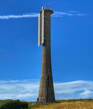
Date unknown. Active; focal plane 80 m (262 ft); continuous white light. 50 m (164 ft) unpainted round tapered concrete tower with gallery. The tower also carries a rectangular slatted daymark painted black with a white vertical stripe on the range line. Google's street view from the Pembrokeshire Coastal Path is at right, Trabas has a photo, Kevin Trahar has another photo, and Google has a street view and a satellite view. This plain modern tower is the tallest lighthouse in the U.K. It is the rear light for the Milford Haven approach range. Located on a promontory on the north side of Milford Haven, about 3.5 km (2 mi) northeast of St. Ann's Head. Accessible along the Pembrokeshire Coastal Path. Site open, tower closed. Operator: Milford Haven Port Authority. ARLHS WAL-042; Admiralty A5286.3; NGA 5620.
* [West Blockhouse Point]
Date unknown. Active; focal plane 21 m (70 ft); quick-flashing light, white or red depending on direction. 2 m (7 ft) red lantern mounted on a concrete base. Trabas has a photo, Nikki Darke has an excellent street view, and Bing has an indistinct satellite view. Located at the foot of a stairway leading down from a fortification; accessible from the Pembrokeshire Coastal Path. Site open, tower closed. Operator: Milford Haven Port Authority. Admiralty A5291; NGA 5640.
 

Watwick Point Light, Milford Haven, May 2016
Google Maps street view
 
* Watwick Point Range Front (3 towers)
Date unknown. Active; focal plane 54 m (177 ft); continuous white light. 13.5 m (44 ft) unpainted concrete post adjacent to a 1-story equipment building. The post carries a rectangular slatted daymark painted black with a white vertical stripe. Trabas has a closeup photo by Arno Siering, and Google has a street view and a satellite view. The light is flanked on either side by two similar posts carrying continuous red lights; the east tower is Admiralty A5286.1, NGA 5624, and the west tower is Admiralty A5286.2, NGA 5628. Located on West Blockhouse Point, a headland 926 m (0.58 mi) southwest of the rear light. Site open, tower closed. Operator: Milford Haven Port Authority. Admiralty A5286; NGA 5616.
* St. Ann's Head (Low) (2)
1841 (station established 1714). Active; focal plane 48 m (157 ft); flash every 5 s, white or red depending on direction. 13 m (42 ft) octagonal cylindrical masonry tower with lantern and gallery; an attached 1970s building was formerly used for control of nearby lighthouses but is now used to support helicopter operations. 1st order Fresnel beehive lens in use. Entire structure painted white. Fog horn (2 blasts every 60 s) located 110 m (120 yd) southwest. Five keeper's houses in a range nearby are currently unused. A 2023 photo is at right, Lighthouse Digest has a good photo by John Mobbs, Trabas has a great closeup by Ian Wright, Wikimedia has several photos, David Purchase has a closeup photo, Marinas.com has aerial photos, and Google has a street view and a satellite view. A privately built lighthouse was in operation here in the 1660s but the early history of the station is somewhat obscure. The five keeper's cottages were all sold in December 2015. Cottage #1 and Cottage #4 are available for vacation accommodations; as of 2018 cottage #5 was again for sale. Located at the point of St. Ann's Head in Pembrokeshire Coast National Park, marking the entrance to Milford Haven. Accessible by road. Site and tower closed. Operator: Trinity House. . ARLHS WAL-027; Admiralty A5284; NGA 5608.
* St. Ann's Head High
1714. Inactive since 1910. 23 m (75 ft) round tapered masonry tower attached to 1-story keeper's houses. The lantern was removed early in World War II and replaced by a rectangular observation room used to watch for German submarines. The entire structure was formerly painted white, but sometime in 2005-06 the tower was painted black; the observation room continues to be white. Robin Lucas has a photo, Gordon Hatton has a 2013 photo, and Google has a street view and a satellite view. Huelse has a historic postcard view showing the original appearance of the lighthouse. In late 2006 the lighthouse was for sale for £1.25 million (reduced by 2012 to £975,000). It was still on sale in early 2015 but was off the market in 2019; in 2021 it was offered again, this time for £995,000; as of June 2023 the price was reduced to £750,000. Located at the point of St. Ann's Head in Pembrokeshire Coast National Park. Accessible by road. Site and lower portion of tower open, entire tower open to guests. Owner/site manager: unknown. ARLHS WAL-051.

St. Ann's Head Low Light, Milford Haven, March 2023
Instagram photo by Lighthouse Accommodation
 
Middle Channel Rock
Date unknown. Active; focal plane 19 m (62 ft); three green flashes every 7 s. 19 m (62 ft) round pillar supporting a round aluminum lantern structure. Trabas has a photo (with the St. Ann's Head lighthouses in the background) and Google has a distant satellite view. The main channel defined by the Watwick Point Range passes just to the west of the rock. Located on a reef about 1.4 km (0.9 mi) south southeast of St. Ann's Head. Accessible only by boat, but easy to see from the St. Ann's Head lighthouse. Site open, tower closed. ARLHS WAL-054; Admiralty A5285; NGA 5612.

Western and Northern Pembrokeshire (Sir Benfro) Lighthouses
Skokholm (Ynys Scogholm)
1916. Active; focal plane 54 m (177 ft); flash every 10 s, white or red depending on direction. 18 m (59 ft) octagonal cylindrical masonry tower with lantern and gallery rising from a 2-story keeper's house. Entire structure painted white. 4th order Fresnel lens in use. A 2023 photo is at right, D.J. Sheret has a great closeup photo, Trabas has a distant view by Ian Wright, Lighthouse Accommodations has a page for the lighthouse, Bob Jones has a good 2010 photo, Wikimedia has several distant views, Marinas.com has aerial photos, Alastair Wilson has a street view from the gallery, and Google has a satellite view. In January 2010 Trinity House proposed that this light be deactivated, but it has remained in service. Skokholm Island is an uninhabited 105 ha (240 acre) island at the southwestern tip of Wales. Famous for its seabirds, it has Britain's oldest bird observatory. In August 2011 the wildlife trust that owns most of the island announced plans to raise £250,000 to purchase the light station property from Trinity House and restore it for overnight accommodations. The purchase took place in May 2012 and four bedrooms are available for stays of at least three days. Located at the southwestern point of the island, about 8 km (5 mi) west northwest of St. Ann's Head. Accessible only by boat. Site open, tower closed. Operator: Trinity House. Owner/site manager: Wildlife Trust of South and West Wales. . ARLHS WAL-022; Admiralty A5282; NGA 5604.

Skokholm Light, Milford Haven, March 2023
Instagram photo by Lighthouse Accommodation
Smalls (2)
1861 (James Douglass). Station established 1776. Active; focal plane 36 m (118 ft); three white flashes every 15 s, day and night. A continuous red light is shown to the east at a focal plane of 33 m (108 ft). A 1st order Fresnel lens is in use. 43 m (141 ft) round tapered stone tower with lantern and gallery, incorporating keeper's quarters, and a helipad mounted above the lantern. The tower is unpainted white granite, lantern painted red. Fog horn (2 blasts every 60 s). Karen Reay's 2019 photo is at right, several closeup photos are available, Lighthouse Accommodations has a page for the lighthouse, Wikimedia has Simon Zarafa's 2018 photo, Wikipedia has an article on the history of the light station, and Google has a satellite view. The light marks the east side of the shipping lane in St. George's Channel, the strait connecting the Celtic Sea to the south and the Irish Sea to the north. Patterned after the famous towers at Bishop Rock and Eddystone, this was Douglass's first great waveswept tower. The original lighthouse, designed by Henry Whiteside, was an innovative cottage lighthouse on piles; it survived countless storms until the present lighthouse was built. Construction required five years. The helipad was added in 1978. Keepers lived in the tower until it was automated in 1987. For many years the lighthouse was painted with red and white horizontal bands; Trinity House removed the paint in 1997, revealing the granite. Located on a tiny island in the southern entrance to the Irish Sea, about 35 km (22 mi) west of St. Ann's Head. Accessible only by helicopter. Site and tower closed. Operator: Trinity House. . ARLHS WAL-023; Admiralty A5278; NGA 5600.

Smalls Light, Irish Sea, August 2019
Google Maps photo by Karen Reay
South Bishop (Emsger)
1839 (James Walker). Active; focal plane 44 m (144 ft); white flash every 5 s. 11 m (36 ft) round brick tower with lantern and gallery, attached to 1-story keeper's house. 4th order Fresnel lens. Entire light station painted white. Fog horn (3 blasts every 45 s). Steven Winter has a great closeup photo, Trabas has a view from the sea, Lighthouse Accommodations has a page for the lighthouse, Janice Lane has a distant view, Mick Garrett has a similar view, Marinas.com has aerial photos, Huelse has a historic postcard view, and Google has a satellite view. Located on a tiny island about 4.8 mi (8 km) southwest of St. David's Head, marking the northern entrance to St. Bride's Bay. Accessible only by helicopter. Site and tower closed. Operator: Trinity House. . ARLHS WAL-024; Admiralty A5276; NGA 5596.
* Strumble Head (Pen Strwmbl, Ynys Meicel)
1908. Active; focal plane 45 m (148 ft); four white flashes, separated by 2.2 s, every 15 s. 17 m (55 ft) round brick tower with lantern and gallery, attached to a 1-story keeper's house. 1st order Fresnel lens in use. Entire light station painted white. A 2024 photo is at right, Lighthouse Accommodations has a page for the lighthouse, John Hayward has an excellent photo, Ian Knox has a good photo, Trabas has a good closeup photo, Wikimedia has many distant views, Lighthouse Digest has a historic postcard view, Huelse has a second postcard view, and Google has a street view and a satellite view. This station is perched on Ynys Meicel (Little Mouse Island), a rocky islet connected to the mainland by a footbridge; it can be seen from the Pembrokeshire Coast Path, a popular hiking trail that follows the coastline, offering spectacular views across St. George's Channel toward Ireland. The trailhead is accessible by by road, parking provided. Located just off a steep headland about 5 km (3 mi) northwest of Fishguard. Site and tower closed. Operator: Trinity House. Site manager: Pembrokeshire Coast National Park. . ARLHS WAL-029; Admiralty A5274; NGA 5592.

Strumble Head Light, Fishguard, May 2024
Instagram photo by ToursWales.com
[Pen Anglas (Penanglas) Fog Signal]
Date unknown. Unlit daybeacon. Approx. 12 m (39 ft) square white stone obelisk. Nearby is a 1-story fog signal enclosure. NGA lists the fog signal as active (two quick blasts every 60 s) but it appears abandoned in a 2008 photo. Arthur C. Harris has a 2013 photo, Trabas has a very distant view, and Bing has a shadowed satellite view. The area is famous for its interesting geology including huge columns of basalt. Located on a sharp point at the western entrance to Fishguard Bay. Accessible by a hiking trail, although it's difficult to reach the structures on the extreme point. Site open. Admiralty A5270; NGA 5588.
* Fishguard (Abergwaun) North Breakwater
1905. Active; focal plane 18 m (60 ft); green flash every 4.5 s. 14 m (46 ft) round two-stage brick tower with lantern and double gallery. The upper half of the tower is round and painted white; the octagonal lower half is unpainted dark stone. Arno Siering contributed the 2013 photo at right, a 2007 photo is available, Trabas has a closeup, and Google has a satellite view and a very distant street view across the harbor. The nearby Strumble Head Light is so much better known this handsome tower doesn't get the attention it deserves. Located at the end of the breakwater in Goodwick, on the north side of Fishguard Harbour; accessible by walking the breakwater. There should be good views from Stena Line ferries connecting Fishguard with Rosslare in southeastern Ireland. Site open, tower closed. Operator: Stena Line. ARLHS WAL-039; Admiralty A5262; NGA 5572.
* Fishguard (Abergwaun) East Breakwater
Date unknown. Active; focal plane 12 m (39 ft); red flash every 3 s. 10 m (33 ft) square skeletal tower, painted white and mounted atop a robust 2-story round concrete tower at the end of the pier. Trabas has a photo, Max Hawkins has a street view, there's a 10-second closeup drone view of the lighthouse, and Google has a satellite view. Located at the end of the breakwater in Goodwick, on the north side of Fishguard Harbour; accessible by walking the breakwater. There should be good views from Stena Line ferries connecting Fishguard with Rosslare in southeastern Ireland. Site open, tower closed. Operator: Stena Line. ARLHS WAL-045; Admiralty A5264; NGA 5576.

North Breakwater Light, Fishguard, May 2013
photo copyright Arno Siering; used by permission

Ceredigion (Cardiganshire) Lighthouses
Cardigan Bay is a broad embayment of the Irish Sea lying off much of the west coast of Wales between Strumble Head in the south and Bardsey Island in the north. The County of Ceredigion, also known historically as Cardiganshire, faces the central and southern portions of the Bay. Mostly rural, it has a population of about 73,000.

* [New Quay (Cei Newydd) (2)]
1937 (station established 1839). Active; focal plane 12 m (39 ft); flash every 3 s, white or green depending on direction. 5 m (17 ft) wood post mounted on a conical stone base. The post is unpainted. Trabas has Eckhard Meyer's photo, Harish Reddy has a street view, and Google has a satellite view. This modest light replaces a historic stone lighthouse that was swept away during a storm in February 1937. In 2017 there was a move to restore it, and we need inforamation as to whether this effortbremains active. Located at the end of the breakwater in New Quay. Accessible by walking the pier. Site open, tower closed. ARLHS WAL-058; Admiralty A5258; NGA 5568.
* [Aberystwyth South Breakwater]
Date unknown (station established 1864). Active; focal plane 12 m (39 ft); two flashes every 10 s, white or green depending on direction. 7 m (23 ft) round post painted with green and white horizontal bands. Trabas has Eckhard Meyer's photo, Steve Fareham has a photo, and Google has a street view and a satellite view. Located on the south breakwater of Aberystwyth. Accessible by walking the pier. Site open, tower closed. Admiralty A5254; NGA 5560.

Lighthouses of North Wales

Gwynedd (Caernarfonshire) Lighthouses
The County of Gwynedd, also known historically as Caernarfonshire, occupies the northwestern mainland of Wales, including the northern portion of the Cardigan Bay coast and the Llŷn Peninsula. The north of the county faces Anglesey across the narrow Menai Strait. The county's population is about 120,000.
St. Tudwal's (Ynys Tudwal)
1877. Active; focal plane 46 m (151 ft); flash every 15 s, white or red depending on direction. 11 m (35 ft) round cylindrical masonry tower with lantern and gallery, painted white. Trabas has a photo, a closeup photo and a drone view are available, Lighthouse Accommodations has a page for the lighthouse, David Medcalf has a very distant view, and Google has a view from the sea and a satellite view. The 1-story keeper's house was sold as a private residence in 1935; the entire island on which the lighthouse stands is now owned.by TV personality Bear Grylls. Trinity House refurbished the lighthouse in 2021 and installed an LED optic. Located on St. Tudwal's Island West, at the western entrance to Tremadoc Bay about 5 km (3 mi) southeast of Abersoch. Accessible only by boat. Site and tower closed. Operator: Trinity House. Site manager: private. ARLHS WAL-028; Admiralty A5238; NGA 5552.
Bardsey (Ynys Enlli)
1821 (Daniel Alexander and Joseph Nelson). Active; focal plane 39 m (129 ft); red flash every 10 s. 30 m (98 ft) square masonry tower with lantern and gallery, painted with red and white horizontal bands. Three 1-story keeper's houses and other buildings. Maria Whitehead's 2020 photo is at right, Lighthouse Accommodations has a page for the lighthouse, Alan Fryer has a closeup photo, David Medcalf has a photo, a distant view of the site is available, Trabas has Ian Wright's view from the sea, Mimi Chan has a 2021 photo, Huelse has a historic postcard view, David Murcutt has a 2017 street view, and Google has a satellite view. The lighthouse marks the northern entrance to Cardigan Bay. Bardsey Island, 3 km (2 mi) off the end of the Llŷn (Lleyn) Peninsula, is a national nature reserve accessible by passenger ferry from Porth Meudwy; several cottages on the island are available for overnight accommodations. In 2014 Trinity House replaced the 2nd order Fresnel lens (1856) with LED lighting and changed the color of the light from white to red in an effort to spare birds who crash into the lighthouse in migration. The disassembled lens was flown by helicopter to the mainland, where it has been reassembled for display at the National Trust's Porth y Swnt Visitor Centre. Located at Pen Diban, the southern end of the island. Accessible by hiking trail, but day trippers must walk the 3 km (2 mi) length of the island to reach the light station. Site open, tower closed. Operator: Trinity House. Site manager: Bardsey Island Trust. (Ymddiriedolaeth Ynys Enlli). . ARLHS WAL-001; Admiralty A5234; NGA 5548.

Bardsey Light, Bardsey Island, September 2020
Instagram photo by Maria Whitehead
Irish Lightship Penguin
1910. Decommissioned 1966. 30.5 m (100 ft) steel lightship converted to a 3-masted schooner. Hull painted black, superstructure white. Wikimedia has several photos. After being decommissioned in 1966, the ship was sold and used as a youth sea training vessel named the Hallowe'en. In 1982 it was sold, converted to a schooner, and renamed the Arctic Penguin. In 1995 it was moored at Inverary, Scotland, as a maritime museum. Dave Forbes has a photo and Google has a 2011 street view of the ship in Scotland. After being for sale for £180,000 for several years, it was sold on Christmas Eve 2015 to Viscount Christopher Wright of Warmingham, Cheshire. In March 2017 the ship sailed under its own power to Barrow-in-Furness for repairs and refitting as a private vessel. In 2018 the ship was at Carmet Marine in Bromborough, upstream from Birkenhead on the River Mersey opposite Liverpool. Since 2020-21 it has been moored at Caernarfon during the winter; Hefin Owen has a March 2024 photo. Site status unknown. Owner/site manager: Viscount Shipping Lines.

Southern and Western Isle of Anglesey (Ynys Môn) Lighthouses
The Isle of Anglesey is an island county about 25 km (15 mi) in diameter just off the northwest corner of the Welsh mainland. The island is separated from the mainland by the very narrow Menai Strait. The population of the island is about 70,000; it is a principal area governed by a county council.

* Llanddwyn Island (2) (Twr Bach, Ynys Llanddwyn)
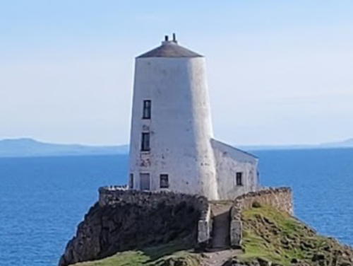
Early 1800s daybeacon, first lit in 1975. Active; focal plane 12 m (39 ft); flash every 2.5 s, white or red depending on direction. 5 m (17 ft) round conical stone tower, painted white. Trabas has a fine closeup by Ian Wright, another closeup photo is available, Tom Haley has a 2022 photo, Wikimedia has distant views, and Google has a street view and a satellite view. A directional light was placed on this daybeacon in 1975 when the 1845 Twr Mawr lighthouse was deactivated. Located at the southern tip of the peninsula. Site open, tower closed. Operator: unknown. Site manager: Newborough National Nature Reserve and Forest. . ARLHS WAL-046; Admiralty A5210; NGA 5528.

Twr Mawr Light, Llanddwyn Island, May 2023
Google Maps photo by Alex Serg
* Llanddwyn Island (1) (Twr Mawr)
1845. Inactive since 1975 but charted as a daybeacon. 11 m (36 ft) round old-style stone tower attached to a keeper's house; photos appear to show abandoned lights atop the tower. Lighthouse painted white. A 2023 photo by Alex Serg is above right, Philip Higgins has a fine photo, Wikimedia has photos, Huelse has a historic postcard view, and Google has a street view and a satellite view. The nearby pilot house is a museum of local maritime history. In 2004 the lighthouse was repainted with its lower half red for its appearance in the movie Half Light starring Demi Moore. Llanddwyn Island--actually a peninsula except at the highest tides--is on the south shore of Anglesey about 5 km (3 mi) west of the southern entrance to Menai Strait. Site of the ruined church of St. Dwynwen and now part of a national nature reserve, the island is accessible by popular hiking trails. Located at the southern tip of the peninsula, a short distance west of the active beacon. Site open, tower closed. Owner: Anglesey government (?). Site manager: Newborough National Nature Reserve and Forest. . ARLHS WAL-057; ex-Admiralty A5210.1.
**** South Stack (Ynys Lawd)
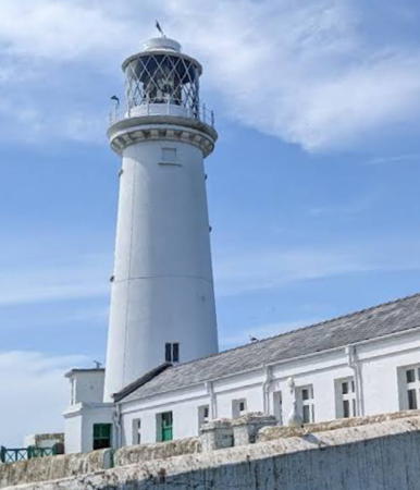
1809 (Daniel Alexander). Active; focal plane 60 m (197 ft); quick white flash every 10 s. 28 m (92 ft) round stone tower with lantern and gallery, attached to 1-story keeper's quarters and service building. Entire structure painted white. Rotating 1st order Fresnel lens. Fog horn (one 3 s blast every 30 s). John Slade's 2022 photo is at right, Trabas has a photo by Arno Siering, Brian Mottershead also has a good photo, Wikimedia has many photos, Lighthouse Accommodations has a page for the lighthouse, Marinas.com has aerial photos, Huelse has a historic postcard view, and Google has a street view and a satellite view. The station includes a Trinity House Visitor Centre. South Stack is a steep-sided island off the western tip of Anglesey. The island is separated from the mainland by a narrow channel crossed by a footbridge since 1828; the present bridge, built in 1997, is the third. Visitors cross the footbridge after descending 400 steps from the parking area and they must climb those steps on their return. Despite the strenuous climb this is a well-visited lighthouse, one of the best known in Britain. However, in early 2017 the Anglesey Council announced it would stop supporting the Visitor Centre as a cost saving measure. After some negotiation Trinity House licensed a new management group, South Stack Ynys Lawd Ltd., and tours resumed in July. Located about 5 km (3 mi) west of Holyhead. Site open, visitor center open and tower open to guided tours daily early April through October and on weekends in March and November (admission fee). Operator: Trinity House. Site manager: South Stack Ynys Lawd. . ARLHS WAL-025; Admiralty A5204; NGA 5520.

South Stack Light, Holyhead, September 2022
Google Maps photo by John Slade
* [North Stack Fog Signal (2)]
1895 (station established 1780). Inactive since 1986. 1-story fog-signal building. The station includes a 1-story keeper's house now used as a private residence. The station was originally equipped with two cannons; the 1861 1-story stone magazine of the cannons survives. The surviving fog-signal building housed a fog siren used until it was discontinued in 1986. The cannons were tossed in the sea; one has been salvaged and is on display at Holyhead Breakwater Country Park (photos are available, halfway down the page). Google has a street view and a satellite view of the station. Accessible by a pleasant hike from the car park of the Country Park. Site open. ex-Admiralty A5202.
* Holyhead (Caergybi) Breakwater
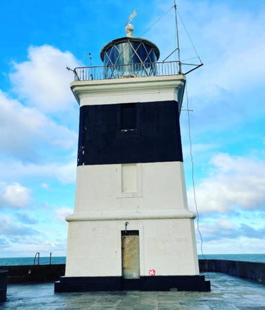
1873. Active (privately maintained); focal plane 21 m (70 ft); three green flashes every 10 s. 19 m (63 ft) square stone tower with lantern and gallery, painted white with a single broad black horizontal band. A 2023 photo is at right, Trabas has a closeup photo, Eric Jones has a 2008 closeup, Aliyah Patrycja Nawrocka has a 2022 photo, Terry Robinson has a 2013 photo, Huelse has a historic postcard view, Uy Hoang has a street view, and Google has a satellite view. Colin Chant's August 2006 photo shows restoration work on the lantern in progress. Located at the end of the long Holyhead Breakwater, the longest in the U.K. at 3 km (9875 ft). Accessible in good weather by walking the breakwater. There's a good views from ferries between Holyhead and Dublin, Ireland. Site open, train transportation available daily in the summer season and on weekends the rest of the year, tower closed. Operator: Stena Line (Holyhead Harbor). . ARLHS WAL-011; Admiralty A5174; NGA 5476.
Holyhead (Caergybi) Mail Pier (Admiralty Pier, Salt Island) (3)
1821 (John Rennie). Inactive for many years. 15 m (49 ft) round old-style stone tower with lantern and gallery. The Lighthouse Digest photo by John Mobbs shows two signal lights, one above the other, on a mast mounted on the gallery, but in a September 2005 email James Doutch reported that these lights have been removed. Dave Leaton has a photo, Tom Haley has a 2022 photo, Stephen Elwyn Roddick has a photo, C.W. Bash has a photo taken from the harbor, and Google has a satellite view and a street view across the harbor. This is one of a pair of lighthouses designed by John Rennie to guide packet boats sailing beween Holyhead and Howth Harbour, near Dublin (see Eastern Ireland for the twin lighthouse). This historic lighthouse, one of the oldest in Wales, does not get the attention it deserves. It is believed that there were two earlier lights at this location, but details of the history are not available. Located at the end of the pier at Salt Island (Ynys Halen) marking the north side of the entrance to the Old Harbour in downtown Holyhead. There's a good views from ferries between Holyhead and Dublin, Ireland. Accessible by walking the pier. Site and tower closed (restricted harbor area). Owner/site manager: Stena Line (Holyhead Harbor). ARLHS WAL-053.

Holyhead Breakwater Light, Holyhead, June 2023
Instagram photo by thehappylifedad

Northern Isle of Anglesey (Ynys Môn) Lighthouses
The Skerries (Ynys Y Moelrhoniaid)
1717 (William Trench). Active; focal plane 36 m (119 ft); two white flashes every 10 s, day and night; also a continuous red light shown over the Coal Rock reef (see next entry). 23 m (75 ft) round cylindrical stone tower with lantern and gallery, attached to a 2-story keeper's house. Tower painted white with a single broad red horizontal band; the red band is continued around the top of the keeper's house so that from a distance a red stripe appears around the whole complex. Ray Clayton's 2023 photo is at right, Lighthouse Accommodations has a page for the lighthouse, Lighthouse Digest has a photo by Tony Denton, Stephen Roddick has a good photo, C.W. Bash has a photo, Peter Godfrey has a closeup, Trabas has Arno Siering's distant view, Huelse has a historic postcard view, and Google has a satellite view. Privately built; in fact, this was the last private lighthouse in Britain when it was finally bought by Trinity House in 1841. This light station marks the extreme northwestern tip of Wales, making it one of the most important lights of the Irish Sea. In 2004 Trinity House restored the keeper's house and received an award for the historic preservation. Located on a small rocky island about 3 km (2 mi) northwest of Carmel Head, Anglesey. Accessible only by boat in dangerous seas. Distantly visible from Carmel Head, which can be reached by hiking the Anglesey Coastal Path. Site and tower closed. Operator: Trinity House. . ARLHS WAL-030; Admiralty A5168; NGA 5472.
* [Carmel Head Beacons]
1860s. Daybeacons, never lit. Two 9 m (30 ft) triangular stone beacons. The seaward side of the beacons was previously painted white, although very little paint remains. Ian Warburton has a view from the sea, Lighthouse Accommodations has a page for the beacons, and Google has a satellite view. These beacons line up with a conical stone beacon on the islet of West Mouse; the line points to Coal Rock, a dangerous reef lying beyond West Mouse. Located at the eastern point of Carmel Head, southeast of the Skerries lighthouse (next entry). Site open.

The Skerries Light, Llanfairynghornwy, Jaanuary 2023
Google Maps photo by Ray Clayton
* Amlwch Old Harbour (2)
1853 (station established 1817). Inactive. Approx. 11 m (36 ft) square stone tower attached to a 1-story stone building; square lantern room with slate roof. Llion Hughes has a good 2006 photo, Robin Drayton has a photo, and Google has a street view and a satellite view. Located at the end of the short pier enclosing the old harbor at Amlwch Port in northwestern Anglesey. Site open, tower closed. Owner/site manager: Isle of Anglesey Council. ARLHS WAL-055.
* Point Lynas (2)
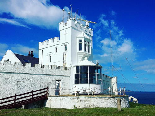
1835 (Jesse Hartley; station established 1779). Active; focal plane 39 m (128 ft); white light, 8 s on, 2 s off. Lantern, at ground level, attached to the front of an 11 m (36 ft) square cylindrical castellated stone tower; the tower, keeper's house, and other structures are enclosed by a high stone wall. In this unusual design, the tower has an observation window above the lantern. 1st order Fresnel lens in use. Fog horn (blast every 45 s). A 2021 photo is at right, Lighthouse Accommodations has a page for the lighthouse, Trabas has a fine closeup, Steve Fareham has a 2007 photo, a 2020 photo is available, Huelse has a historic postcard view, Joseph Mearman has a street view, and Google has a satellite view. The original lighthouse was 300 m to the south. Like Great Orme, the light station was built by the Mersey Docks and Harbour Board and transferred to Trinity House in 1973. In 2000 Trinity House sold the station to Robin and Iona Beckmann, who spent the next decade restoring the buildings. In 2010 the Beckmanns placed the property for sale for £1.5 million; in 2014 it was still for sale with the price reduced to £1.375 million. Apparently it did sell and the new owners have renovated several keeper's cottages for overnight accommodation. Located on Point Lynas, about 1 km (0.6 mi) north of Llaneilian. Probably accessible by road; if not, it's a short walk from parking in Llaneilian. Site and tower closed (private property), but the lighthouse can be seen from nearby. Operator: Trinity House. Owner/site manager: Point Lynas Lighthouse . ARLHS WAL-019; Admiralty A5160; NGA 5464.

Point Lynas Light, Llaneilian, October 2021
Instagram photo by love_a_lighthouse
* Trwyn Du (Penmon Point)
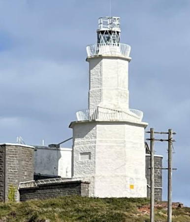
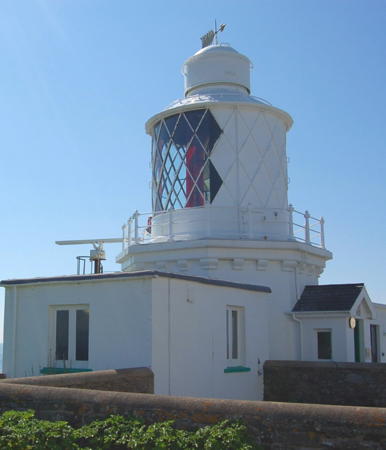
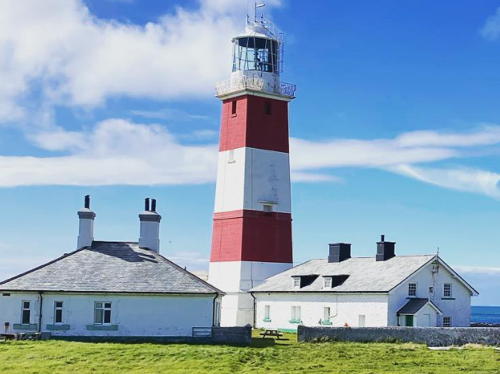
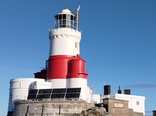
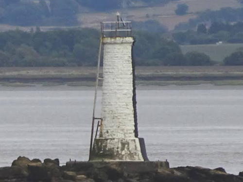
1838 (James Walker). Active; focal plane 19 m (63 ft); white flash every 5 s. 29 m (62 ft) round cylindrical castellated stone tower with lantern and gallery, painted with black and white horizontal bands; the lantern is white. The historic 178 kg (392 lb) fog bell remains in place but it was replaced by a foghorn in 2019. David Cumbley's 2023 photo is at the top of this page, Lighthouse Digest has a photo by Tony Denton, Trabas has Ian Wright's closeup, Jeff Buck has a photo, there's a 2008 photo showing waves breaking against the tower, Lighthouse Accommodations has a page for the lighthouse, Wikimedia has many photos, Marinas.com has aerial photos, Huelse has a historic postcard view, Matt Vickery has a street view, and Google has a satellite view. The lighthouse stands at the northeastern corner of the Isle of Anglesey marking the northern entrance to Menai Strait, which separates the island from the Welsh mainland. In 1996 Trinity House renovated the lighthouse by converting it to solar power and installing a mechanism to operate the fog bell. A foghorn was installed (to the dismay of neighbors) when this mechanism became unreliable in 2019. In 2022 one of the two privately-owned onshore keeper's houses was for sale for £1.7 million. Located just off the point of Trwyn Penmon about 1200 m (3/4 mi) northeast of Penmon. It is possible to walk to the lighthouse at low tide, although the rough shingle beaches are rather difficult walking. Also visible from cruises out of Beaumaris. Site open, tower closed. Operator: Trinity House. . ARLHS WAL-031; Admiralty A5140; NGA 5420.

Conwy Lighthouse
The County Borough of Conwy faces north on the Irish Sea east of the Isle of Anglesey. It has a population of about 120,000.
** Great Orme Head (Llandudno)
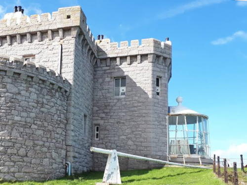
1862 (G. Lyster). Inactive since 1985. 11 m (37 ft) lantern attached to a 2-story castellated keeper's house. The original 1st order Fresnel lens is on display nearby at the Great Orme Summit Complex. Bert Kos has a closeup photo, Lighthouse Accommodations has a page for the lighthouse, Anna Nowak has a view from above, Les Johnson has a 2022 closeup, Eric Jones has a 2008 photo from the rear of the building, and Google has a satellite view and a distant street view. The Great Orme is a huge limestone promontory jutting into the Irish Sea north of Llandudno. This remarkable lighthouse is perched high on a vertical cliff at the northern end of the promontory. Built by the Mersey Docks and Harbour Board, it was transferred to Trinity House in 1973 and deactivated 12 years later. It then became a bed and breakfast inn; the lantern room is now a sitting room with a spectacular view of the sea. Located on Marine Drive (a toll road) about 5 km (3 mi) northwest of Llandudno. Site open, tower open to paying guests. Owner/site manager: The Lighthouse - Llandudno . ARLHS WAL-008; ex-Admiralty A5134.

Flintshire (Sir y Fflint) Lighthouse
Flintshire is a small county in the northeastern corner of Wales. Much of the county faces eastward on the marshy estuary of the River Dee. The county's population is about 160,000.

* Point of Ayr (Talacre)
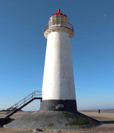
1776. Inactive since 1883. 18 m (58 ft) round brick tower with lantern and gallery, painted white; lantern painted black, lantern dome red. Petereurwen Owen's 2023 photo is at right, another good photo is available, Eugene Everson has a 2008 photo, Grzegorz Wieczorek has a 2018 closeup, Kenny Gresty has a street view from the beach, and Google has a satellite view. Built to mark the entrance to the Dee estuary, the lighthouse was replaced by a lightship in 1883. Though long abandoned, this lighthouse was maintained in fair condition by its owner, James McAllister, who bought it at auction in 1983. In November 2011 McAllister offered the lighthouse for sale for £100,000. It sold sometime in 2012-13. The new owners found the tower to be in poor condition and have been working steadily to patch leaks and restore the masonry. They capped off their work by repainting the tower in 2022, and it looks great in the photo at right. The lighthouse is surrounded by water at high tide but it can be reached easily across a broad, flat beach when the tide is low. The surrounding land is a nature preserve, the Gronant and Talacre Dunes SSSI. Located on the beach about 1 km (0.6 mi) west of Point of Ayre. Accessible by walking about 800 m (0.5 mi) from Talacre, a short distance off the A548 coastal highway. Site open, tower closed. Owner/site manager: private. . ARLHS WAL-018.

Point of Ayr Light, Talacre, February 2023
Google Maps photo by Petereurwen Owen

Information available on lost lighthouses:

Notable faux lighthouses:

Adjoining pages: North: Isle of Man | Northeast: Northwestern England | Southeast: Western England

Return to the Lighthouse Directory index | Ratings key

Posted November 15, 2004. Checked and revised June 9, 2024. Lighthouses: 49, lightships: 3. Site copyright 2024 Russ Rowlett and the University of North Carolina at Chapel Hill.