Lighthouses of France: Haute-Normandie (Eastern Normandy)

France (officially the French Republic, République française) has coasts facing south on the Mediterranean Sea, west on the open Atlantic Ocean, and north on the English Channel (La Manche in French). Long a leader in lighthouse design, France has scores of famous and historic lighthouses. And it was a French engineer and physicist, Augustin-Jean Fresnel (1788-1837), who invented the powerful and beautiful lenses used in lighthouses around the world.

Normandy is a former duchy in the northwest of France, named for the Vikings ("Northmen") who invaded and settled it in the 9th century. William, Duke of Normandy, conquered England in 1066 and through the end of the 12th century the dukes of Normandy were also kings of England.

Metropolitan (European) France is divided into 13 administrative regions (régions) and the regions are divided into departments (départements). In 2016 the former administrative regions of Basse-Normandie (Lower Normandy) and Haute-Normandie (Upper Normandy) were combined to form a unified Normandie region. This page lists lighthouses of Haute-Normandie, the eastern part of the Normandie region including the départements of Eure and Seine-Maritime. Located on both sides of the lower River Seine this is the Normandy of Claude Monet's paintings, with a picturesque coastline overlooking La Manche (the English Channel). Also included is the great port of Le Havre at the mouth of the Seine.

This coastline saw fierce fighting during World War II, especially during the three months after the Allied D-Day invasion of 6 June 1944. Very few of the lighthouses in the area escaped damage and many were destroyed.

The French word for a lighthouse, phare, is often reserved for the larger coastal lighthouses; a smaller light or harbor light is called a feu (literally "fire," but here meaning "light") or a balise (beacon). The front light of a range (alignement) is the feu antérieur and the rear light is the feu postérieur. In French île is an island, cap is a cape, pointe is a promontory or point of land, roche is a rock, récife is a reef, baie is a bay, estuaire is an estuary or inlet, détroit is a strait, rivière is a river, and havre is a harbor.

Aids to navigation in France are maintained by the Bureau des Phares et Balises, an agency of the Direction des Affaires Maritimes (Directorate of Maritime Affairs). The Directorate has four regional offices (called Directions Interrégionale de la Mer, or DIRM) at Le Havre, Nantes, Bordeaux, and Marseille. Lights in Normandie are managed by the DIRM Nord-Atlantique Manche Est - Mer du Nord (DIRM-MEMN) at Le Havre.

ARLHS numbers are from the ARLHS World List of Lights. FR numbers are the French light list numbers, where known. Admiralty numbers are from volume A of the Admiralty List of Lights & Fog Signals. U.S. NGA List numbers are from Publication 114.

General Sources
Phares de la DIRM MEMN
Lighthouse information from the DIRM regional office.
Les Sentinelles des Mers - France Nord
Photos and information posted by Guy Detienne.
Le Phare à travers le Monde
A large, well known site maintained by Alain Guyomard and Robert Carceller.
Online List of Lights - France North Coast
Photos by various photographers posted by Alexander Trabas. Many of the photos for this area are by Capt. Peter Mosselberger ("Capt. Peter").
Phareland, le Site des Phares de France
This comprehensive site has good photos and information about the major lighthouses.
Leuchttürme.net - Frankreich
Photos and notes by Malte Werning.
Lighthouses in Normandie
Photos by various photographers available from Wikimedia.
Lighthouses in France
Aerial photos posted by Marinas.com.
Société Nationale pour le Patrimoine des Phares et Balises (S.N.P.B.)
The French national lighthouse preservation organization.
Französische Leuchttürme
Historic photos and postcard images posted by Klaus Huelse.
GPSNavigation Charts
Navigation chart information for Normandie.
Navionics Charts
Navigation chart for Normandie.


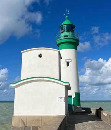
Cap d'Antifer Light, Étretat, July 2018
Wikimedia Creative Commons photo by Unukorno
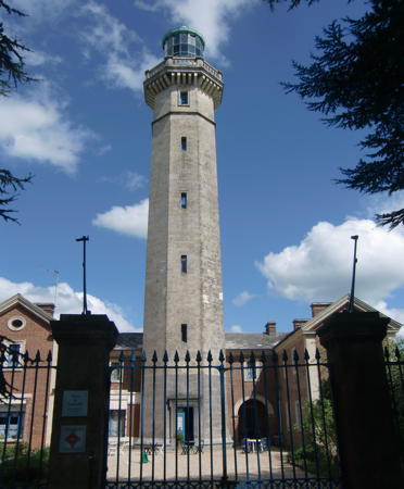

Fatouville Light, Fatouville, May 2012
Wikimedia Creative Commons photo by Gérard Janot
Département de l'Eure Lighthouses

Seine Left Bank Lighthouses
* Pointe de la Roque (Saint-Samson de la Roque) (2)
1850 (station established 1838) (Léonce Reynaud). Inactive since 1910. 10 m (33 ft) square cylindrical masonry tower with lantern and gallery, rising from one end of a 2-story keeper's house. Lantern, tower and house roof painted black, house white. Gérard Janot's photo also appears in the French Wikipedia article on the lighthouse, Werning has a good photo, Lighthouse Digest has a photo by Xavier Leroy, a 2023 photo is available, and Google has a street view and a satellite view. The building is boarded up but it appears to be maintained in good condition. The lighthouse was deactivated because it is 800 m (1/2 mi) south of the river, too far away to be useful for navigation. In 2021 there was a proposal to transfer ownership to the town of Saint-Samson-de-la-Roque. Located atop a steep bluff overlooking the south side of the river near Saint-Samson-de-la-Roque, about 5 km (3 mi) west of the Tancarville bridge and across the river from the Tourelle Ygou (see below). Accessible by road; parking provided. Site open, tower closed. Owner/site manager: Département de l'Eure. . ARLHS FRA-460.
* Quillebeuf-sur-Seine (2)
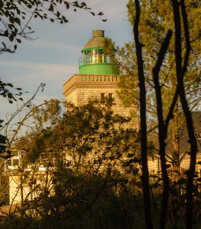
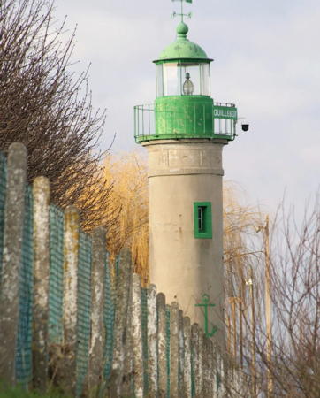
1862 (station established 1817) (Léonce Reynaud). Active; focal plane about 11 m (36 ft); continuous white light. 10 m (33 ft) round cylindrical stucco-clad brick tower with lantern and gallery, unpainted; the lantern is painted green. Mylène Lefèvre's 2023 photo is at right, Werning has a photo, Trabas has aCapt. Peter's photo, Wikimedia has a photo by Gérard Janot, Jean-Luc Lemaître has a photo of the lighthouse in the fog, French Wikipedia has an article, Huelse has a nice postcard view, and Google has a street view and a satellite view. The lighthouse was recognized as a historic monument in 2011; according to the citation its appearance has not changed since 1905. Located on the south bank of the river in the Place du Phare, at the north end of the quay at Quillebeuf-sur-Seine, about 4 km (2.5 mi) above the Tancarville bridge. Accessible by road; parking provided. Site open, tower closed. Owner/site manager: national government. Site open, tower closed. . ARLHS FRA-444; Admiralty A1324.
* Fatouville
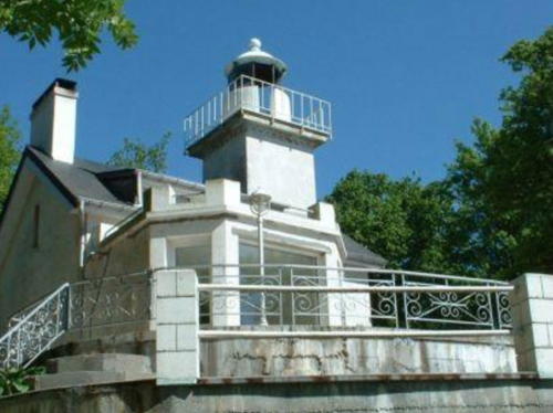
1850 (Léonce Reynaud). Inactive since 1909. 32 m (105 ft) octagonal stone tower with lantern and gallery, attached to a 2-story keeper's house. Gérard Janot's photo is at the top of this page, Frederic Laine has a closeup photo, Werning has a photo, Michel Donnet has a 2009 photo, French Wikipedia has an article on the lighthouse, Huelse has a historic postcard view, and Google has a street view and a fine satellite view. This elegant lighthouse, regarded as one of the finest designs of the lighthouse engineer Léonce Reynaud, was sold into private hands and is now operated by Anne Durand as a guest house with five suites for overnight accommodations. The lighthouse was deactivated because it is 1500 m (0.9 mi) south of the river, too far away to be useful for navigation. The light station was restored and recognized as a historic monument in 2010. Located on a hilltop in Fatouville, about 7 km (4 mi) west of Honfleur off the D312 highway. Site open, tower closed. Owner/site manager: Le Phare de Fatouville . ARLHS FRA-282.

Quillebeuf-sur-Seine Light, January 2023
Instagram photo by Mylène Lefèvre

Département de la Seine-Maritime Lighthouses

Seine Right Bank (Tancarville) Lighthouses
Tancarville is a village on the north bank of the Seine about 23 km (14 mi) east of Le Havre.

Saint-Jean de Folleville
Date unknown. Active; focal plane about 10 m (33 ft); red light, pattern unknown. Approx. 8 m (26 ft) tripod tower with gallery standing over a 1-story metal equipment shelter. Gallery painted red. Trabas has Capt. Peter's photo and Google has a satellite view. Located at a sharp bend on the north side of the river, adjacent to a sand and gravel quarry. Site and tower closed. Site manager: Société Parisienne Sablières. Admiralty A1320.
Tancarville
1838. Inactive since 1868. 10 m (30 ft) square cylindrical masonry tower with lantern and gallery, rising from one end of a 2-story keeper's house. Lighthouse and entire building painted white. Lightphotos.net has Andreas Köhler's closeup photo seen at right, Guyomard and Carceller have a photo and Google has a street view (from the Tancarville Bridge) and a good satellite view. Sold in 1901 and long in use as a private residence, the house has been expanded and altered from its original appearance. Located on a bluff on the north side of the Seine just east of the Tancarville bridge (A131 highway) about 30 km (19 mi) west of Le Havre. There's a view from the bridge. Owner/site manager: unknown. Site and tower closed. Owner/site manager: private. ARLHS FRA-766.
Ygou (Tourelle Ygou) (2?)
1922 (?) (station established in the mid 1800s). Active; focal plane 7 m (23 ft) (?); quick-flashing red light. 13 m (43 ft) square skeletal tower with gallery mounted atop a round solid concrete or stone tower. Skeletal tower painted red. Trabas has Capt. Peter's photo and Google has a satellite view. The focal plane has probably been raised to at least 12 m (39 ft). A brief notation by J.-C. Fichou provides the date 1922 but the 1858 Brown's Nautical Almanac lists the Tourelle Ygou at the present location with a continuous red light. Located on the north bank of the Seine at the Marais-Vernier wetlands, about 6 km (3.5 mi) west of Tancarville. Accessible only by boat. Site and tower closed. ARLHS FRA-853; Admiralty A1308.

Tancarville Light, Tancarville, May 2003
Lightphotos.net photo by Andreas Köhler; used by permission

Le Havre Lighthouses
Founded by King François I in 1517, Le Havre ("The Harbor") is the second largest port of France, after Marseille. The city is built on the right (east) bank of the Seine at its mouth. Much of the city had to be rebuilt after it suffered devastating damage during World War II.

Port 2000 Leading
Date unknown. Active; focal plane about 22 m (72 ft); continuous white, red or green light, depending on direction. Approx. 20 m (66 ft) round white concrete tower painted with black and white horizontal bands. Trabas has Capt. Peter's photo and Google has a satellite view. Port 2000 is a new basin on the south side of the Quai du Havre dredged to accommodate the largest containerships. Work began in 2000 and the port opened in 2006. Located midway on a long breakwater enclosing the new port. Accessible only by boat. Site and tower closed. Admiralty A1258.
Port 2000 Turning Area Range Rear
Date unknown. Active; focal plane about 22 m (72 ft); red light, pattern unknown. Approx. 20 m (66 ft) round white concrete tower. Trabas has Capt. Peter's photo and Google has a satellite view. Located at the east end of the Port 2000 harbor. Site and tower closed. Admiralty A1258.9.
Le Havre Nouvelle Digue Sud (2)
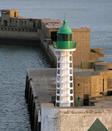
1948 (station established 1906). Active; focal plane 15 m (49 ft); three very quick green flashes every 2 s. 15 m (49 ft) round cylindrical tower with lantern, gallery, and six buttresses. Tower painted white, lantern green. Trabas has an excellent photo by Douglas Cameron (also seen at right), Andreas Köhler has a 2018 photo, Werning has a photo showing recent restoration work in progress, and Google has a satellite view and a very distant street view. Huelse has a historic postcard view of the original Nouvelle Digue lighthouses, which were destroyed during the fighting after D-Day in 1944. The replacement lights were built on the same design as the originals. Located at the end of the south breakwater at Le Havre. Site status unknown. ARLHS FRA-165; Admiralty A1264; NGA 8656.
Le Havre Nouvelle Digue Nord (2)
1948 (station established 1906). Active; focal plane 15 m (49 ft); red flash every 5 s. 15 m (49 ft) round cylindrical tower with lantern, gallery, and six buttresses. Tower painted white, lantern red. Fog horn (3 s blast every 15 s). Werning has a good photo, Trabas has a good photo by Capt. Peter, Hervé Therry has a 2020 photo, and Google has a satellite view and a distant street view. Located at the end of the north breakwater at Le Havre. Site status unknown. ARLHS FRA-164; FR-27990; Admiralty A1262; NGA 8648.
[Bassin Théophile Ducrocq Directional (2)]
Date unknown. Active; focal plane 15 m (49 ft); white, red or green light, depending on direction, occulting once every 4 s. 13 m (43 ft) steel post, painted white with a green top. Trabas has a photo and Google has a satellite view. This was formerly a 13 m (43 ft) round cylindrical concrete tower with gallery, painted white with a green horizontal band. Located at the end of a pier on the south side of the harbor, adjacent to a petroleum tank farm. Site and tower closed. Admiralty A1274.6; NGA 8700.
* Quai d'Escale Antérieur (Quai Roger-Meunier) (3)
1971 (station established 1935). Active; focal plane 36 m (118 ft); continuous white light, intensified on the range line. 35 m (115 ft) 12-sided concrete tower with a large lantern structure. Tower is unpainted gray concrete, lantern painted green. Trabas has Capt. Peter's photo, Werning has a photo, Karl Golhen has a photo of the lighthouse and the French Navy helicopter carrier Mistral, and Google has a street view and a fine satellite view. This is the entrance range for Le Havre. The Quai d'Escale is one of the major quays of Le Havre, located southeast of the breakwaters; the lighthouse is located adjacent to the city's Cruise Welcome Centre. Site open, tower closed. ARLHS FRA-764; Admiralty A1260; NGA 8632.
Nouvelle Digue Sud Light
Nouvelle Digue Sud Light, Le Havre
photo copyright Douglas Cameron; used by permission
* Quai d'Escale Postérieur (Quai Joannès-Couvert) (3)
1971 (station established 1935). Active; focal plane 78 m (256 ft); continuous white light, intensified on the range line. 77 m (253 ft) 16-sided concrete tower with lantern. Tower is unpainted gray concrete, lantern painted green. Trabas has Capt. Peter's photo, Fichou has a drawing and Google has a closeup street view and an excellent satellite view. This is one of the world's tallest aids to navigation. Located on the Avenue Lucien Corbeaux, 1370 m (0.85 mi) east southeast of the front light and adjacent to the Gare Maritime. Site open, tower closed. ARLHS FRA-765; Admiralty A1260.1; NGA 8636.
#Swedish Lightship 28 Falsterborev
1910 (rebuilt 1930-31). Decommissioned 1976. 30.2 m (99 ft) steel lightship with light tower and lantern, painted red. Eric Houri has a 2002 photo. Decommissioned after four decades of service at the Falsterborev station in the Baltic, the ship took on a new career in 1977 as a restaurant in Nieuwpoort, Belgium. It sank at its berth in 1994 but was raised and repaired. After the restaurant closed in 2002 the ship was towed to Le Havre, where plans to reopen it as another restaurant fell through. Iris Klempau spotted the ship in July 2004, moored at the Quai de Brésil in "very poor condition." Sometime in the night of 17-18 August 2007 the ship sank at its berth again, leaving only the lantern above water. The vessel was raised and scrapped in 2012. ARLHS FRA-749.
* Lightship Le Havre III
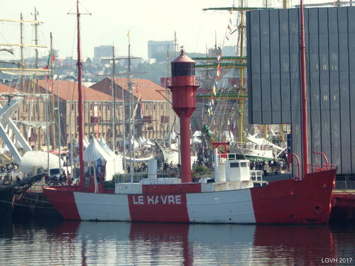
1935. Decommissioned 1983. 42.5 m (139 ft) steel lightship; cylindrical light tower with lantern amidships. Vessel painted red with bold white vertical stripes on the sides. A photo is at right, Karl Golhen has a September 2009 photo, a 2014 photo is available, Markkus Nelrog has a 2022 closeup, and Google has a 2018 street view and a satellite view. One of only two surviving French lightships. Before World War II the ship served as the Dunkerque, but from 1949 until its retirement in 1983 it served only the station off Le Havre. In 1988 the city of Le Havre purchased the ship and donated it to the city-owned maritime museum. In 2004-05 the ship was drydocked and restored at a cost of €120,000. It looked great in an April 2006 photo. Since 2014-15 the ship has been moored at the Quai Renaud next to the museum. Site open, vessel status unknown. Owner/site manager: Musée maritime et portuaire du Havre. ARLHS FRA-670.

Lightship Le Havre III, Le Havre, September 2017
Wikimedia Creative Commons photo by Raphodon
#Passe Ancienne Feu Antérieur
Date unknown. Inactive since 2009 and prromptly removed. This was an 18 m (59 ft) square skeletal tower. Google has a 2008 street view but its 2010 street view confirms the removal. Formerly located at the entrance to the yacht harbor at 180 Boulevard Clemenceau. Site open. ex-Admiralty A1261; ex-NGA 8640.
Passe Ancienne Feu Postérieur
Date unknown. Inactive since 2009 and probably removed. 41 m (135 ft) square cylindrical tower on the roof of an 8-story apartment building. No photo available but Google has a satellite view. There is probably no view of the light tower from the street. The front light was on a pylon somewhere near the yacht harbor (Anse des Regates). Located on the south side of the Rue Paul Doumer, near the southwest corner of the Place de l'Hôtel de Ville in Le Havre. Site open, tower closed. ex-Admiralty A1261.1; ex-NGA 8644.
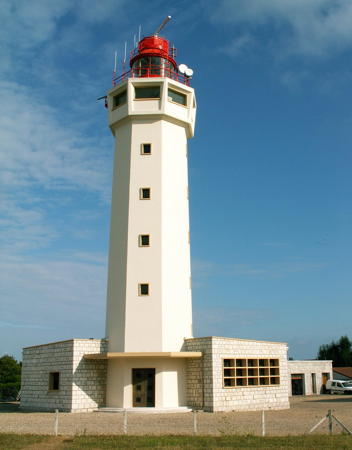
* Cap de la Hève (2)
1951 (station established 1775). Active; focal plane 123 m (404 ft); white flash every 5 s. 32 m (105 ft) octagonal concrete tower with an 8-sided observation room, lantern, and gallery, attached to 1-story concrete block service and control building. The tower is unpainted white concrete; lantern painted red. The photo at the right is from DIRM's page for the lighthouse, Wikimedia has several photos, Trabas has Capt. Peter's closeup photo, Valerie Simon has a 2021 photo, Werning has a good photo, and Google has a street view and an excellent satellite view. This is the landfall light for Le Havre and the Seine, and thus one of France's most important light stations. Lights were displayed here as early as the 14th century. In 1775 elegant twin lighthouses 17 m (56 ft) high were built atop the cliffs. These lighthouses were the first in France to be electrified; the south tower was lit in 1863 with electricity generated by a steam engine. In 1893 the south light was deactivated and its lantern replaced by a square room, as seen in Huelse's historic postcard view of the lighthouses. The historic towers were destroyed by Allied artillery during fighting at Le Havre in 1944. Located on the Rue du Carrousel, on the cape, on the north side of the entrance to Le Havre and the Seine estuary, about 5 km (3 mi) northwest of the Le Havre waterfront. Accessible by road; streetside parking is usually available. Site open, tower closed. . ARLHS FRA-223; FR-105000; Admiralty A1256; NGA 8628.

Fécamp and St.-Valéry-en-Caux Lighthouses
* Antifer Feu Antérieur
Date unknown. Active; focal plane 113 m (371 ft); white light occulting once every 4 s. 7 m (23 ft) concrete post with a large round lantern room on one side of the post. Trabas has Capt. Peter's photo and Google has a satellite view. Located in a field near the edge of the cliffs off the Rue des Tulipes, about 6 km (4 mi) southwest of the Cap d'Antifer lighthouse. Site open, tower closed. Admiralty A1250.2; NGA 8727.
* Antifer Feu Postérieur
Date unknown. Active; focal plane 124 m (407 ft); white light occulting once every 4 s. 13 m (43 ft) concrete post with a large round lantern room on one side of the post. Trabas has Capt. Peter's photo and Google has a satellite view and a very distant street view. Located at a right-angled bend of the Rue des Tulipes, about 6 km (4 mi) southwest of the Cap d'Antifer lighthouse. Site open, tower closed. Admiralty A1250.21; NGA 8727.1.

Cap de la Hève Light, Le Havre
DIRM photo
* Cap d'Antifer (2)
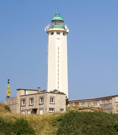
1955 (station established 1894). Active; focal plane 128 m (420 ft); white flash every 20 s. 38 m (125 ft) octagonal concrete tower with 8 ribs, lantern and gallery. Tower is unpainted gray concrete, lantern and gallery painted green. Modern 1-story keeper's house. A photo is at the top of this page, DIRM has a page for the lighthouse, Sébastien Robert has a 2021 photo, Trabas has a closeup photo by Heike and Friedrich Klatt, Werning also has a photo, a 2009 photo is available, and Google has a street view and a satellite view. The original lighthouse, a 26 m (85 ft) masonry tower, was destroyed by retreating German forces on 29 August 1944; Huelse has posted a lovely postcard view of that lighthouse. Located atop the cliffs west of Étretat, the same cliffs made famous by some 20 paintings of Claude Monet (painted in 1885, before there was a lighthouse). and other Impressionist painters. Accessible by road; limited parking. Site open, tower closed. . ARLHS FRA-220; FR-100000; Admiralty A1250; NGA 8740.
* Fécamp Digue Sud (Feu Antérieur) (4)
About 1952 (station established 1859). Active; focal plane 14 m (46 ft); quick-flashing green light. 10 m (33 ft) semielliptical concrete tower; lantern removed. The tower, a twin of the north pier light, is unpainted gray concrete. Werning has a good photo, Trabas has Capt. Peter's photo, Roberto Albertini has a photo showing both Fécamp lighthouses, and Google has a street view and a satellite view. The harbor of Fécamp, partially protected by the sheer headland of Cap Fagnet, faces to the west rather than the north. The 1901 lighthouse was destroyed during World War II; Huelse has a historic postcard view and Michel Forand has a closeup postcard view. This light is also the front light of the harbor entrance range (NGA incorrectly calls it the rear light). The rear light is on a tall post near the base of the pier. Located at the end of the south pier in Fécamp; accessible by walking the pier. Site open, tower closed. ARLHS FRA-163; Admiralty A1246; NGA 8756.
* Fécamp Digue Nord (4)
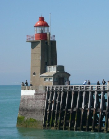
About 1952 (station established 1805). Active; focal plane 15 m (49 ft); two white flashes every 10 s. 14 m (46 ft) semielliptical concrete tower with lantern and gallery. Tower is unpainted gray concrete, lantern and gallery painted red. Fog horn (two blasts every 30 s). Emmanuel Blum's photo is at right, Trabas has a good photo by Capt. Peter, Carlos Martinez has a 2023 photo, Roberto Albertini has a photo showing both Fécamp lighthouses, and Google has a street view and a satellite view. The 1899 lighthouse was destroyed during World War II; Huelse has a historic postcard view, and Michel Forand has a different postcard view. Located at the end of the north pier in Fécamp; accessible by walking the pier. Site open, tower closed. . ARLHS FRA-162; Admiralty A1244; NGA 8752.
Feu de la Digue Nord, Fécamp
Digue Nord Light, Fécamp, May 2010
Flickr Creative Commons photo by Emmanuel Blum
* Cap Fagnet (Fécamp, Pointe Fagnet)
1836. Inactive since 1901. This was originally a 15 m (50 ft) square stone tower rising from the center of a 1-story stone keeper's house. The light had a focal plane of 130 m (426 ft) and was often obscured by fog. The lighthouse was converted to a signal station in 1904 and during World War II a large square observation room was added. The tower is now about 21 m (70 ft) tall, not counting a communications tower added in recent years. Raymond Gerard has a 2021 photo and Google has a street view and a satellite view. Huelse has a historic postcard view. Located on the Route du Phare atop a steep bluff on the north side of Fécamp. Site open, tower closed. ARLHS FRA-756.
* St.-Valéry-en-Caux (Jetée de l'Ouest) (3)
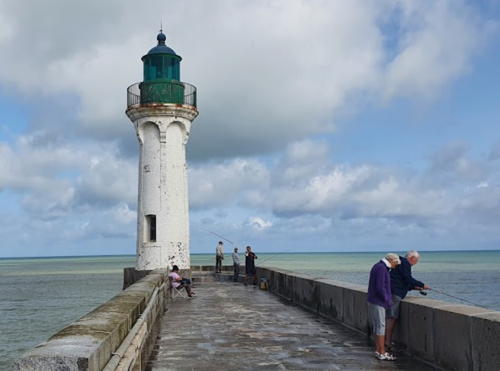
1882 (station established 1805). Active; focal plane 13 m (43 ft); two green flashes every 6 s. 12 m (39 ft) round masonry tower with lantern and gallery, painted white; lantern and gallery painted green. Elia Salvetta's 2021 photo is at right, Trabas has Capt. Peter's photo, Nathalie Martin has a 2023 photo, Guyomard and Carceller have photos, Huelse has a historic postcard view, and Google has a street view and a satellite view. Located at the end of the west jetty in St.-Valéry-en-Caux, about 50 km (30 mi) east of Fécamp and the same distance west of Dieppe. Accessible by walking the jetty. Site open, tower closed. ARLHS FRA-152; Admiralty A1238; NGA 8760.
* [St.-Valéry-en-Caux Jetée de l'Est (Jetée d'Amont) (3?)]
1960 (station established 1857). Active; focal plane 8 m (26 ft); two red flashes every 6 s. 6 m (20 ft) mast. Trabas has Capt. Peter's photo, and Google has a satellite view of the location. Huelse has a historic postcard view of the previous lighthouse, and Michel Forand has a closer postcard view. Both views show the 1914 lighthouse, which was destroyed during World War II. Located at the end of the west jetty in St.-Valéry-en-Caux. Accessible by walking the jetty. Site open, tower closed. ARLHS FRA-502; Admiralty A1239; NGA 8764.
 

Jetée de l'Ouest Light, St.-Valéry-en-Caux, August 2021
Google Maps photo by Elia Salvetta
 

Dieppe and Le Tréport Lighthouses
*** Pointe d'Ailly (3)
1953 (station established 1775; inactive 1940-1944). Active; focal plane 95 m (312 ft); three quick white flashes, separated by 4 s, every 20 s. 27 m (89 ft) square cylindrical cement block tower with lantern and gallery, attached to a 1-story keeper's house. A photo is at right, DIRM has a page for the lighthouse, Trabas has Capt. Peter's photo, Alain Gourreau has a closeup 2020 photo, Wikimedia has a photo by Félix Potuit, Marinas.com has aerial photos, and Google has a street view and a satellite view. The Pointe d'Ailly is a picturesque but rapidly eroding headland, famous from Monet paintings. The original lighthouse, a beautiful square masonry tower seen in Michel Forand's postcard view, was replaced by an elegant octagonal tower in 1890 because erosion was bringing the cliff close to the station. Huelse has a postcard view showing both the 1775 and 1890 lighthouses. Retreating German forces blew up the 1890 lighthouse on 30 August 1944. Allied forces then rigged a temporary light to the top of the 1775 tower, which was by then at the brink of the cliff, and had the light in operation for New Year's Eve, 31 December 1944. The Service des Phares et Balises has a photo of the temporary light. The old tower continued in operation to 1958 and finally collapsed over the cliff in 1964. The present lighthouse is about 400 m (1/4 mi) southwest of the point and 300 m from the edge of the cliff. Located near Sainte-Marguerite-sur-Mer, about 16 km (10 mi) west of Dieppe. Site open, lighthouse open for tours during July and August. . ARLHS FRA-012; FR-92000; Admiralty A1234; NGA 8768.
* Dieppe Jetée de l'Ouest (5)
1990s (station established 1787). Active; focal plane 11 m (36 ft); green light, 2 s on, 2 s off. 7 m (23 ft) square tower with lantern and gallery, attached to 1-story service building. The tower appears to be built from prefabricated reinforced concrete panels in a style suggesting the late 1950s or early 1960s. Trabas has Capt. Peter's photo, François Revidat has a 2021 photo, and Google has a street view and a satellite view. Huelse has a historic postcard view of the third tower, a cast iron tourelle installed in 1915. Michel Forand has a second postcard view of the 1915 lighthouse and a postcard view of the 1834 masonry lighthouse. The 1915 tower did not survive World War II. Located at the end of the west jetty in Dieppe, which also serves as the main breakwater. Accessible by walking the jetty. Site open, tower closed. . ARLHS FRA-263; Admiralty A1230; NGA 8776.

Pointe d'Ailly Light, Sainte-Marguerite-sur-Mer, September 2019
Flickr Creative Commons photo by Oeil de verre
[Dieppe Jetée de l'Est (3)]
Date unknown (station establish 1834). Active; focal plane 12 m (39 ft); red light, 2 s on, 2 s off. Approx. 6 m (20 ft) mast, painted red. Guyomard and Carceller have Christophe Toullec's photo of the present light, Trabas has Capt. Peter's photo, and Google has a street view and a satellite view of the site. The cast iron tourelle seen in the Lighthouse Explorer photo was installed in 1903 and relocated in 1913 when the jetty was extended. It was removed sometime in the 1980s. Located at the end of the east jetty of Dieppe. Site status unknown. ARLHS FRA-262; Admiralty A1228; NGA 8788.
* Falaise du Pollet
About 1950. Active; focal plane 35 m (115 ft); quick-flashing white light. 4 m (13 ft) square concrete "pillbox," the light shown through a square opening. Structure painted white with a red rectangle surrounding the window. This light replaced a rear range light that was displayed from the steeple of the Chapelle de Bon Secours. Guyomard and Carceller have a photo that shows the current light in front of the church, Trabas has Capt. Peter's closeup photo, and Google has a street view and a satellite view. Located on the bluff above Dieppe harbor, about 100 m (330 ft) southwest of the church. Site open, tower closed. ARLHS FRA-851; Admiralty A1232.1; NGA 8784.
* Dieppe Alignement (feu postérieur) (1)
Date unknown (between 1935 and 1948). Inactive. Light displayed from the steeple of the Chapelle de Notre Dame de Bon Secours. Google has a street view and a satellite view. The range has been discontinued, and a single light is now displayed from a small concrete structure in front of the church (previous entry). Located on a bluff looming above Dieppe harbor, at the end of the Chemin du Sémaphore. Site open, tower closed. ARLHS FRA-849.
* Le Tréport Jetée de l'Ouest (4)
1905 (station established before 1807). Active; focal plane 15 m (49 ft); two green flashes every 10 s. 14 m (46 ft) round cylindrical tower with lantern and gallery. Most of the tower is painted white; the lantern, gallery and the top of the tower are painted dark green. A 2-story service building is adjacent to the lighthouse; a fog bell is mounted on the roof. A 2023 photo is at right, Trabas has Capt. Peter's photo, Wikimedia has photos, Huelse has a historic postcard view, Nathan Maas has a closeup street view, and Google has a satellite view. The original lighthouse was replaced in 1836 and again in 1865; Michel Forand has a postcard view of the 1865 lighthouse. Located at the end of the short west jetty in the fishing port of Le Tréport. Accessible by walking the jetty. Site open, tower closed. . ARLHS FRA-523; Admiralty A1222; NGA 8792.

Jetée de l'Ouest Light, Tréport, October 2023
Instagram photo by Sousou

Irish Lightship in Paris

** Irish Lightship Batofar (née Osprey)
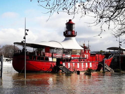
1955 (Philip & Son Ltd., Dartmouth, England). Deactivated 1975. 36.3 m (119 ft) steel lightship; octagonal skeletal light tower with lantern and gallery amidships. Vessel painted red. Walter Galvani has a photo, Christophe Jacquet has a photo, and Google has a street view and a satellite view. We need information on the ship's active career. In 1975 it was deactivated and sold to the New Ross Harbour Commission, which used it as a floating oil berth and pilot station. In 1998 it was sold to French owners, towed to Paris, renamed Batofar, and opened as a discothèque. ("Batofar" is a contraction of the French word bateau-phare for a lightship.) Moored opposite no. 11 Quai François Mauriac in Paris, on the left bank of the Seine just below the Pont de Tolbiac. Site open, ship open nightly. Site manager: Batofar . ARLHS FRA-822.

Information available on lost lighthouses:

  • Berville-sur-Mer (Rivière Risle) (1869-1940s), south side Seine estuary, Eure. The lighthouse was not replaced after World War II. ARLHS FRA-672.
  • Hodé (Saint-Vigor-d'Ymonville) (1838-1970s), north side Seine estuary, Seine-Maritime. The lighthouse was discontinued in 1882; its ruins were removed sometime after 1968. ARLHS FRA-778.
  • Le Havre Jetée Nord (1791-1906). The Jetée Nord and Jetée Sud lights were replaced in 1906 by the Nouvelle Digue lights (see above). A second postcard view shows the lighthouse after most of the jetty had been removed. (Both views show the 1843 tower.) ARLHS FRA-775.
  • Le Havre Jetée Sud (1840-1906). Another cast iron tourelle. The Jetée Nord and Jetée Sud lights were replaced in 1906 by the Nouvelle Digue lights (see above). ARLHS FRA-776.

Notable faux lighthouses:

  • Cloche des Dockers (1911), Quai du Brésil, Le Havre. Often mistaken for a lighthouse, this is a bell tower that sounded shift changes for dockworkers. The bells were discontinued in 1964. Google has a street view and a satellite view.

Lightship Batofar, Paris, January 2018
Instagram photo by Batofar

Adjoining pages: East: Pas de Calais | West: Basse-Normandie

Return to the Lighthouse Directory index | Ratings key

Posted July 6, 2006. Checked and revised November 12, 2023. Lighthouses: 28; lightships: 3. Site copyright 2023 Russ Rowlett and the University of North Carolina at Chapel Hill.