Lighthouses of France: Basse-Normandie (Western Normandy)

France (officially the French Republic, République française) has coasts facing south on the Mediterranean Sea, west on the open Atlantic Ocean, and north on the English Channel (La Manche in French). Long a leader in lighthouse design, France has scores of famous and historic lighthouses. And it was a French engineer and physicist, Augustin-Jean Fresnel (1788-1837), who invented the powerful and beautiful lenses used in lighthouses around the world.

Normandy is a former duchy in the northwest of France, named for the Vikings ("Northmen") who invaded and settled it in the 9th century. William, Duke of Normandy, conquered England in 1066 and through the end of the 12th century the dukes of Normandy were also kings of England.

Metropolitan (European) France is divided into 13 administrative regions (régions) and the regions are divided into departments (départements). In 2016 the former administrative regions of Basse-Normandie and Haute-Normandie were combined to form a unified Normandie region. This page lists lighthouses of the former Basse-Normandie (Lower Normandy), region; this is the western portion of the ancient Duchy of Normandy, including the two coastal départements of Manche and Calvados, the Cotentin Peninsula, and the port of Cherbourg.

This is also the Normandy of the D-Day invasion of 6 June 1944, and the entire region saw some of the fiercest fighting of World War II in Western Europe. Very few of the lighthouses in the area escaped damage and many were destroyed.

The French word for a lighthouse, phare, is often reserved for the larger coastal lighthouses; a smaller light or harbor light is called a feu (literally "fire," but here meaning "light") or a balise (beacon). The front light of a range (alignement) is the feu antérieur and the rear light is the feu postérieur. In French île is an island, cap is a cape, pointe is a promontory or point of land, roche is a rock, récife is a reef, baie is a bay, estuaire is an estuary or inlet, détroit is a strait, rivière is a river, and havre is a harbor.

Aids to navigation in France are maintained by the Bureau des Phares et Balises, an agency of the Direction des Affaires Maritimes (Directorate of Maritime Affairs). The Directorate has four regional offices (called Directions Interrégionale de la Mer, or DIRM) at Le Havre, Nantes, Bordeaux, and Marseille. Lights in Normandie are managed by the DIRM Nord-Atlantique Manche Est - Mer du Nord (DIRM-MEMN) at Le Havre.

ARLHS numbers are from the ARLHS World List of Lights. FR numbers are from the French light list Feux et signaux de brume, where known. Admiralty numbers are from volume A of the Admiralty List of Lights & Fog Signals. U.S. NGA List numbers are from Publication 114.

General Sources
Phares de la DIRM MEMN
Lighthouse information from the DIRM regional office.
Les Sentinelles des Mers - France Nord
Photos and information posted by Guy Detienne.
Le Phare à travers le Monde
A large, well known site maintained by Alain Guyomard and Robert Carceller.
Online List of Lights - France North Coast
Photos by various photographers posted by Alexander Trabas. Many photos for France are by Capt. Peter Mosselberger ("Capt. Peter").
Phareland, le Site des Phares de France
This comprehensive site has good photos and information about the major lighthouses.
Leuchttürme.net - Frankreich
Photos and notes by Malte Werning.
France Lighthouses
Aerial photos posted by Marinas.com.
Lighthouses in Normandie
Photos by various photographers available from Wikimedia.
Société Nationale pour le Patrimoine des Phares et Balises (S.N.P.B.)
The French national lighthouse preservation organization.
Französische Leuchttürme
Historic photos and postcard images posted by Klaus Huelse.
Navionics Charts
Navigation chart for Normandy.


Cap Lévi Light, Fermanville, December 2009
Wikimedia Creative Commons photo by Sky60038
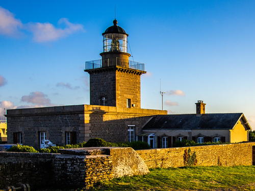

Cap de Carteret Light, Carteret, July 2020
Flickr Creative Commons photo by Stefan Klaas
Département de la Manche Lighthouses

Mont Saint-Michel and Granville Lighthouses

*
Mont Saint-Michel (2) (Tour Gabriel)
1881 (station established 1870). Inactive since 1904. Approx. 8 m (26 ft) round cylindrical stone tower with a conical roof, known as the Tour Gabriel (Gabriel Tower). A closeup photo of the tower is available and Google has a street view and a satellite view. Mont Saint-Michel is a famous and historic fortified abbey on an island in the southeastern corner of the Baie du Mont Saint-Michel at the base of the Cotentin peninsula. The Tour Gabriel is located at the base of the mount, on the west side of the island. The abbey is surrounded by a large area that is covered with water at high tide but dry at low tide. The light was displayed "from 2 hours before to 1-1/2 hour after high water," according to an 1895 light list. During this brief interval it was possible for small boats to approach the abbey. The light was discontinued when it was observed that no boats were making use of this service. Located at the abbey, about 5 km (3 mi) north of Beauvoir. Site open, tower closed. ARLHS FRA-760.
Le Loup
1893. Active; focal plane 8.5 m (28 ft); two white flashes every 6 s. 24 m (79 ft) round stone tower painted black with two red horizontal bands. Trabas has a closeup photo by Stephen Hix, Herve Marchand has a street view from the Granville east jetty, Daniel Théau has a drone view of this light and the two jetty lights (next entries), and Bing has an indistinct satellite view. Located on a dangerous rock about 400 m (1/4 mi) south of Granville harbor. Accessible only by boat. Site open, tower closed. ARLHS FRA-694; Admiralty A1666; NGA 8040.
* Granville Jetée Est
Date unknown (station established 1832). Active; focal plane 11 m (36 ft); green flash every 2.5 s. 9 m (30 ft) three-legged steel pylon with gallery, painted green and rising from a round stone tower. The two jetty lights flash simultaneously. Trabas has Capt. Peter's closeup photo, Philippe Marsault has a 2021 closeup, and Google has a satellite view. Located on the east breakwater at Granville; accessible by walking the pier. Site open, tower closed. Admiralty A1664; NGA 8048.
* Granville Jetée Ouest
Date unknown (station established 1832). Active; focal plane 12 m (39 ft); red flash every 2.5 s. 9 m (30 ft) three-legged steel pylon with gallery, painted red and rising from a round stone tower. Trabas has Capt. Peter's closeup photo, Herve Marchand has a street view from the east jetty, and Google has an indistinct satellite view. Huelse has a historic postcard view of the original lighthouse, a 10.5 m (34 ft) round stone tower; it was destroyed in D-Day fighting in 1944. Located on the main breakwater at Granville; accessible by walking the pier. Site open, tower closed. ARLHS FRA-757; Admiralty A1662; NGA 8044.
* Granville (Pointe du Roc, Cap Lihou)
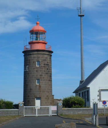
1827. Active; focal plane 49 m (161 ft); four white flashes every 15 s. 16 m (52 ft) round stone block tower with lantern and gallery. Tower unpainted, lantern and gallery painted red; the name Granville is painted on the side of the tower in white. 2-story stone keeper's house. There is a modern signal station just below the lighthouse. A photo is at right, Aimee Cardwell has a photo, Trabas has a closeup by Capt. Peter, Marinas.com has aerial photos, and Google has a street view and a satellite view. This lighthouse, painted with camouflage patterns, survived World War II without damage. Located atop a rocky promontory called the Roc du Granville, marking the entrance to Granville harbor. Site open, tower closed; there's also a good view from ferries arriving from Jersey. . ARLHS FRA-126; FR-517000; Admiralty A1660; NGA 8036.
 
Cap Lihou Light
Cap Lihou Light, Granville, August 2012
Wikimedia Creative Commons photo by HaguardDuNord

Îles Chausey Lighthouses
The Îles Chausey are a small group of islands in the middle of the entrance to the Baie du Mont St.-Michel, about 20 km (13 mi) west northwest of Granville and a similar distance north of Cancale Port-Mer. The islands are part of the Granville Commune.
* Îles Chausey
1847 (rebuilt and reactivated 1950). Active; focal plane 39 m (128 ft); white flash every 5 s. 19 m (62 ft) square cylindrical stone tower with lantern and gallery, rising from a 2-story stone keeper's house. A photo by Alain Auzas is at right, Dr. Karl Agre has a photo, François Levalet has an aerial photo, Trabas has Werner Seiler's photo, Wikimedia has several views of the lighthouse, Huelse has a historic postcard view, and Google has a satellite view. The lighthouse was heavily damaged during World War II and needed extensive reconstruction following the war. The light is automated but is staffed as a control center for navigation in the bay. Located at the highest point of Grand Île Chausey, which is accessible by ferry from St.-Malo or Granville. Site open, tower closed. . ARLHS FRA-005; FR-515000; Admiralty A1654; NGA 8020.
La Crabière Est
Date unknown. Active; focal plane about 11 m (36 ft); white, red or green light depending on direction, occulting three times every 12 s. 11 m (36 ft) square pyramidal skeletal tower painted black with a yellow top. Trabas has Werner Seiler's photo and Google has a distant satellite view. The light guides small vessels in a rocky passasge. Located on rocks off the east end of the Îles Chausey. Accessible only by boat. Site open, tower closed. ARLHS FRA-717; Admiralty A1655; NGA 8024.
Le Pignon
Date unknown. Inactive since 2022. 20 m (66 ft) round stone tower painted with black and white horizontal bands. Endangered. A photo and a painting are available but the light is only a fuzzy spot in Bing's satellite view. This light marks the eastern edge of the shallows and reefs surrounding the Îles Chausey. Storms in recent years caused a break in the tower, leaving the upper half with a lean; as of 2020 the recommended plan was to remove and replace the upper section. But the light apparently has been abandoned; it was dropped by the Admiralty in October 2022. Note that there is another Pignon lighthouse near Penerf in Morbihan. Located about 10 km (6 mi) east of the islands. Accessible only by boat. Site open, tower closed. ARLHS FRA-116; ex-Admiralty A1656; NGA 8028.


Îles Chausey Light, Granville, August 2006
Wikimedia public domain photo by Alain Auzas


Regnéville and Gouville-sur-Mer Lighthouses
Le Ronquet
Date unknown. Active; focal plane 11 m (36 ft); two flashes every 6 s, white or red depending on direction. 11 m (36 ft) round stone beacon, painted with black and red horizontal bands. Yann Renouf has a closeup photo, Trabas has Capt. Peter's distant view and Bing has a satellite view. Located on a reef about 4 km (2.5 mi) west of Pointe d'Agon. Accessible only by boat. Site open, tower closed. ARLHS FRA-823; Admiralty A1649; NGA 8054.
* Regnéville-sur-Mer
Date unknown. Active; focal plane 12 m (39 ft); white or red light, depending on direction, occulting twice every 6 s. The light is mounted on a chimney at one end of a 1-story stone building, perhaps the port captain's office. Trabas has Capt. Peter's closeup photo and Google has a street view and a satellite view. Located on the Rue du Port in Regnéville-sur-Mer. Site open, tower closed. ARLHS FRA-852; Admiralty A1651; NGA 8060.
* Pointe d'Agon (Regnéville)
1856 (heightened in late 1940s). Active; focal plane 12 m (39 ft); white light occulting twice every 6 s; red light is shown over a sector to the west to warn ships away from the rocks off the point. 12 m (40 ft) square cylindrical stone tower with lantern and gallery attached to the rear of a 1-story stone keeper's house. Rémi Vincent's photo is at right, Trabas has Capt. Peter's closeup photo, Guyomard and Carceller have a photo by Yves Bossuroy, Wikimedia has a photo and a second photo, Huelse has a historic photo, and Google has a street view and a satellite view. This light marks the north side of the entrance to the harbor of Regnéville-sur-Mer. The lighthouse was badly damaged during World War II; when it was repaired after the war the tower was raised in height from the original 7 m (23 ft). Accessible by road, the Charrière de la Chevrottière; parking is available 200 m (220 yd) away at the end of the road. Located at the end of a long point of land about 7 km (4 mi) south of Agon. Site open, tower closed. . ARLHS FRA-166; Admiralty A1650; NGA 8056.

Pointe d'Agon Light, Regnéville, Christmas Day 2009
Flickr Creative Commons photo by Rémi Vincent
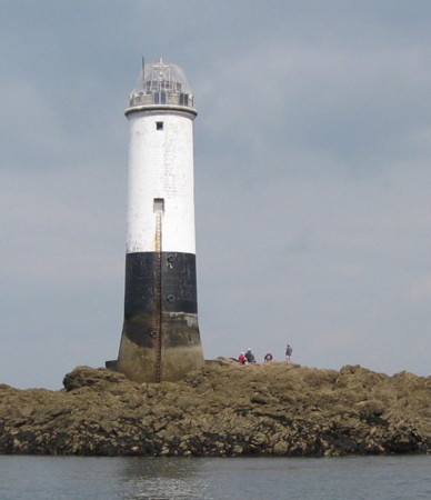
Le Sénéquet
1861. Active; focal plane 18 m (59 ft); three white flashes every 12 s; red flashes are shown over a sector to the west to warn ships away from the rock. 18 m (59 ft) round stone tower with gallery. The upper 2/3 of the tower is painted white; the lower portion has a black band above unpainted very dark stone. Keepers tended this lighthouse until it was automated in 1938. The lantern and optical equipment were removed after being heavily damaged during World War II; a new lantern was added after the war but removed in 1981. The light is now shown from a short mast atop the tower. A photo is at right, Trabas has Capt. Peter's photo, and Bing has a satellite view. Huelse has a postcard view showing the tower's original appearance. Located on a rock about 5 km (3 mi) west of Gouville-sur-Mer. Accessible only by boat. Site and tower closed. ARLHS FRA-035; FR-512000; Admiralty A1648; NGA 8064.

Portbail, Barneville-Carteret, and Flamanville Lighthouses
* Portbail Feu Postérieur (Église de Notre-Dame)
Date unknown. Active; focal plane 20 m (66 ft); white light, 3 s on, 1 s off. Light mounted in the stone tower of the Église de Notre-Dame, a Norman church whose foundations were laid in 1026, although most of the building dates from the 12th and 13th centuries. The light is displayed through a tiny rectangular window near the top of the tower. Trabas has Capt. Peter's closeup photo showing the light, Phillippe Boîte has posted an excellent photo of the church, and Google has a street view and a satellite view. At one time the tower was painted white as a daymark, as seen in the postcard posted by Huelse. No longer a church, the building is now used as the town meeting hall. The front light is on a small skeletal tower. Located on the waterfront in Portbail, about 10 km (6 mi) southeast of Barneville-Carteret. Site open, church open, tower status unknown. ARLHS FRA-763; Admiralty A1644.1; NGA 8072.
* Carteret (Cap de Carteret)
1830 (rebuilt in late 1940s). Active; focal plane 81 m (266 ft); three white flashes, in a 2+1 pattern, every 15 s. 18 m (59 ft) square cylindrical stone tower with lantern and gallery, rising from the front of a 1-story stone keeper's house. Tower is unpainted; lantern and gallery rail painted dark green. 2nd order Fresnel lens in use. Stefan Klaas's photo is at the top of this page, Trabas has a closeup photo, Wikimedia has a photo also showing the nearby signal station, Frank Stoll has a 2022 photo, Huelse has a historic postcard view, Marinas.com has aerial photos, and Google has a street view and a satellite view. This historic lighthouse faces the British island of Jersey across a strait about 20 km (13 mi) wide. In 1870 the keeper's house was enlarged by constructing 1-story wings on both sides. German troops occupied the lighthouse in World War II, leading the Allies to destroy it in an air raid in late April 1944. It was rebuilt after the war using the original plans. The light was automated in 1976 but the building has remained in service as a regional control center for ship traffic and aids to navigation along the west side of the peninsula. Located on the cape, at the end of the Route du Sémaphore, about 2 km (1.2 mi) west of Carteret. Parking provided. There's also a good view from ferries between Carteret and the Channel Islands. Site open, tower closed. . ARLHS FRA-084; FR-507000; Admiralty A1638; NGA 8080.

Le Sénéquet Light, September 2008
ex-Panoramio Creative Commons photo by chr95
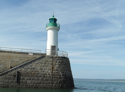
* Diélette (Digue Ouest, feu antérieur) (4)
1897 (station established 1858). Active; focal plane 12 m (39 ft); white, red, or green light depending on direction, 2 s on, 2 s off; for harbor entrance, there is also a green light flashing once every 4 s at a focal plane of 6 m (20 ft). 9 m (30 ft) round cylindrical masonry tower with lantern and gallery, painted white; lantern and gallery painted green. Jenšíková's photo is at right, Trabas has Capt. Peter's photo, Gérard Poirier has posted a nice photo showing winter waves sweeping around the lighthouse, a 2007 photo (taken from a kite) and a 2020 closeup are available, Huelse has a lovely postcard view, and Google has a street view and a satellite view. The lighthouse was the front light of a range until sometime in the late 1990s. The original light was replaced by cast iron towers in 1876 and again in 1896; a storm swept the latter light away after only four months of service. Located at the end of breakwater pier at Diélette on the west side of the Cotentin peninsula. Accessible by walking the breakwater; there is also a good view from ferries between Diélette and the Channel Islands. Site open, tower closed. . ARLHS FRA-261; Admiralty A1632; NGA 8092.
* Diélette Feu Postérieur (2)
1876 (station established 1858). Inactive since the late 1990s. 1-1/2 story keeper's house; the light was displayed through a window of the upper story. Google has a satellite view and a street view from below the house. The light was deactivated when the front light was converted to a sector light. Located on the slope of the hill behind the harbor, 466 m (1530 ft) from the front light. Site probably open. Owner: unknown. ARLHS FRA-820; ex-Admiralty A1632.1.

Digue Ouest Light, Diélette
Comité Régional du Patrimoine Maritime Normand photo

Digulleville (Cap de la Hague) Lighthouses
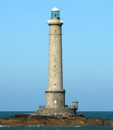
Cap de la Hague (Goury)
1837 (Morice de la Rue). Active; focal plane 48 m (157 ft); white flash every 5 s. 51 m (167 ft) round granite tower with lantern and gallery, mounted on a 1-story cylindrical granite base. Fog horn (blast every 30 s). Tower unpainted, lantern dome painted white. James Stringer's photo is at right, DIRM has a page for the lighthouse, Trabas has Capt. Peter's photo, Riccardo Andrian has a 2021 photo, Stéphane Dauguet has a nice 2007 photo, Huelse has a historic postcard view, Eric Mattmann has a street view from the mainland, and Google has a satellite view. The Cap de la Hague is the northwestern tip of the Cotentin peninsula, making this light a crucial point of reference for ships sailing eastward. The lighthouse also guards the Alderney Race (Raz Blanchard), the 16 km (10 mi) wide channel between Cap de la Hague and Alderney, the northeasternmost of Britain's Channel Islands. The Race has some of the fastest and most dangerous tidal currents in the world. The lighthouse took three years to build. Fortunately it escaped major damage during World War II, and it was staffed until 1990. Two 2-story keeper's houses survive at Goury on the mainland; Google has a street view of one of them. Extensive repairs to the lantern were completed in late 2013; materials and workmen were ferried to the lighthouse by helicopter. Located on a small waveswept island, Gros-du-Raz, about 800 m (1/2 mi) west of the cape. Accessible only by boat in dangerous seas but there is a good view from the beach at the end of the road about 1.6 km (1 mi) west of Auderville. Site and tower closed. . ARLHS FRA-031; FR-504000; Admiralty A1512; NGA 8304.
La Plate
Date unknown (1950s or 1960s). Active; focal plane 11 m (36 ft); three flashes, in a 2+1 pattern, every 10 s; white flashes are shown to the south and red flashes to the north. 10 m (33 ft) octagonal cylindrical tower. No lantern; the light is shown from a short mast atop the tower. A watch room inside the top of the tower is accessed by an outside ladder. The tower is painted with a black horizontal band at the top and a yellow band below the black; the lower half of the tower is unpainted. Trabas has Thomas Philipp's closeup photo and Google has a satellite view and a distant street view. Note: there is another, better-known Feu de la Plate off the Pointe du Raz in Finistère. Located atop a waveswept rock 3 km (1.8 mi) northeast of the Cap de la Hague lighthouse. Accessible only by boat. Site and tower closed. Admiralty A1514; NGA 8312.
Omonville-la-Rogue
Date unknown. Active; focal plane 13 m (43 ft); white, red or green light depending on direction, 2 s on, 2 s off. 12 m (39 ft) mast mounted on a 1-story equipment shelter. Lighthouse painted white with a red top. Trabas has Capt. Peter's photo and Google has a satellite view. Located just off the beach on the south side of Omonville-la-Rogue, about 10 km (6 mi) east of Cap de la Hague. Site open, tower closed. ARLHS FRA-375; Admiralty A1508; NGA 8308.

Cap de la Hague Light, Auderville, September 2015
Flickr Creative Commons photo by James Stringer

Cherbourg Area Lighthouses
Cherbourg, now known officially as Cherbourg-en-Cotentin, is a historic seaport at the north end of the Cotentin Peninsula. Long a departure port for transatlantic liners, it continues as an important terminal for cross-Channel ferries. The modern harbor is protected by a series of outer breakwaters.

*
Dique Ouest (Dique de Querqueville)
Date unknown. Active; focal plane 8 m (26 ft); two green flashes every 6 s. 7 m (23 ft) square pierhead building topped by a light on a short green mast. Trabas has Capt. Peter's photo, Simon Banks has a street view, and Google has a satellite view. The Dique de Querqueville is the westernmost of a series of breakwaters protecting the harbor of Cherbourg. Completed in 1896 it is about 1 km (0.6 mi) long. Located at the east end of the breakwater. Accessible by walking the pier (a popular walk in good weather). Site open, tower closed. Admiralty A1482; NGA 8320.
Fort de l'Ouest
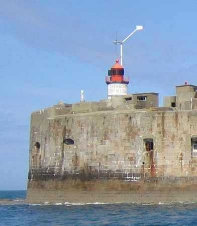
1840. Active; focal plane 19 m (62 ft); three flashes every 15 s, white or red depending on direction. 9 m (30 ft) round granite tower with lantern and gallery. Tower painted white; lantern painted red. Fresnel lens in use. Trabas has Capt. Peter's photo, French Wikipedia has an article with the photo at right, Richard Peters has a 2018 drone view, Huelse has a historic postcard view, and Google has a satellite view and a distant street view from shore. The lighthouse stands atop a nineteenth century circular stone fort. Located about 2.5 km (1.5 mi) northwest of the Cherbourg waterfront at the western end of the Digue Centrale, a detached breakwater. Accessible only by boat but there should be good views from ferries linking Cherbourg to Portsmouth, England, and Rosslare, Ireland. Site and tower closed. ARLHS FRA-046; FR-499000; Admiralty A1480; NGA 8332.
Jetée du Homet (Dique du Homet)
Date unknown. Active; focal plane 10 m (33 ft); quick-flashing green light. 9 m (30 ft) square pierhead building topped by a light on a short green mast. Trabas has Capt. Peter's photo and Google has a distant sea view, but the pier is fuzzed out in Google's satellite view. Located at the end of the west inner breakwater of Cherbourg harbor. Site and tower closed (restricted military area). ARLHS FRA-715; Admiralty A1486; NGA 8352.
* Gare Maritime (Fort du Homet feu postérieur) (2?)
Date unknown. Active; focal plane 35 m (115 ft); quick-flashing white light, visible only on the range line. 35 m (115 ft) square pyramidal skeletal tower atop a square cylindrical stone tower, one of the four towers of Cherbourg's historic Gare Maritime, where transatlantic and trans-Channel passengers transferred between ships and trains. The building is now occupied by the Cité de la Mer, an oceanographic institute and museum. Trabas has Capt. Peter's photo, Georges Enguehard has a photo (light on the left tower), G. Hine has a street view from a ship, and Google has a satellite view. The front light is mounted on a stone wall at the Fort du Hamet. Site open, tower closed. Admiralty A1484.1; NGA 8328.
[Fort Central (2)]
1952 (station established 1839). Active; focal plane 5 m (17 ft); six very quick white flashes followed by one long white flash every 10 s. 3 m (10 ft) post, upper half painted yellow and lower half black. The original light here was in a 16.5 m (54 ft) round stone tower with lantern and gallery. This lighthouse was deactivated in 1895; it is not known when it was destroyed. Trabas has Capt. Peter's closeup photo of the light, Richard Peters has a good view of the ruined fort, Sandra Tejnecká has a photo, and Google has a satellite view of the fort and a distant street view from shore. Located in front of a nineteenth century fort in the central section of the detached Digue Centrale. Accessible only by boat. Site and tower closed. ARLHS FRA-753; Admiralty A1478; NGA 8336.

Fort de l'Ouest Light, Cherbourg, May 2006
Wikimedia Creative Commons photo by Thbz
[Fort de l'Est (2?)]
Date unknown (station established 1910). Active; focal plane 19 m (62 ft); green light, 2 s on, 2 s off. 9 m (30 ft) pylon, lower portion painted white and upper portion green. Trabas has Capt. Peter's photo and Google has a distant street view from shore and a satellite view of the ruins. The previous light was a round cylindrical tank with the light mounted at the top. Located at the eastern end of the detached Digue Centrale. Accessible only by boat. Site and tower closed. ARLHS FRA-240; Admiralty A1476; NGA 8340.
Fort de l'Île Pelée (Dique Est) (3?)
Date unknown (station established 1900). Active; focal plane 19 m (62 ft); white or red light depending on direction, 1 s on, 1 s off, 3 s on, 1 s off. 8 m (26 ft) square pierhead building topped by a light on a short red mast. Trabas has Capt. Peter's photo and Google has a distant satellite view. Located atop a fort at the western end of eastern outer breakwater of Cherbourg. Site status unknown. ARLHS FRA-818; Admiralty A1470; NGA 8344.
* Le Becquet Feu Antérieur
Date unknown (station established 1862). Active; focal plane 8 m (26 ft); white light, occulting three times, in a 2+1 pattern, every 12 s, intensified on the range line and synchronized with the rear light. 6 m (20 ft) octagonal cylindrical concrete tower with gallery, attached to 1-story concrete equipment room. Trabas has Capt. Peter's closeup photo, Andreas Köhler has a good photo of the two range lights, and Google has a street view and a satellite view. Located on the waterfront in Le Becquet de Tourlaville, about 5 km (3 mi) east of the Cherbourg waterfront. Site open, tower closed. ARLHS FRA-191; Admiralty A1466; NGA 8404.
* Le Becquet Feu Postérieur
Date unknown (station established 1862). Active; focal plane 12 m (39 ft); red light, occulting three times, in a 2+1 pattern, every 12 s, intensified on the range line and synchronized with the front light. 10 m (33 ft) octagonal cylindrical concrete tower with gallery, attached to 1-story concrete equipment room. Trabas has Capt. Peter's photo, Andreas Köhler has a good photo of the two range lights, and Google has a street view and a satellite view. Located on the waterfront in Le Becquet de Tourlaville, about 5 km (3 mi) east of the Cherbourg waterfront. Site open, tower closed. ARLHS FRA-192; Admiralty A1466.1; NGA 8408.

Fermanville and Gatteville-le-Phare Lighthouses
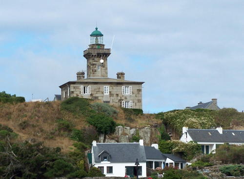
* Cap Lévi (Cap Levy) (2)
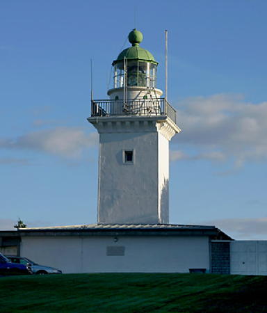
1948 (station established 1858). Active; focal plane 38 m (118 ft); red flash every 5 s. 27 m (89 ft) 4-sided granite block tower with lantern and gallery, the sides being incurved (concave). Tower unpainted, lantern painted white. A photo is at the top of this page, Arno Siering's photo is at right, Trabas has Peter Doll's closeup, a good 2008 photo is available, Phareland has many photos, Marinas.com has fine aerial photos, and Google has a street view and a satellite view. Huelse has a historic postcard view of the original lighthouse, a square granite tower that was blown up by Germn troops during the fighting for Cherbourg shortly after D-Day. The unusual design of the new lighthouse is by the architects Levavasseur et Chauliat. Located on a headland jutting into the Manche about 20 km (13 mi) northeast of Cherbourg and 2.5 km (1.5 mi) northwest of the village of Fermanville. Accessible by road; parking available nearby at the end of the road. Site open, tower closed. . ARLHS FRA-080; FR-473000; Admiralty A1462; NGA 8416.

Cap Lévi Light, Fermanville
photo copyright Arno Siering; used by permission
* Pointe de Barfleur (Gatteville) (1)
1780. Inactive since 1835. 25 m (82 ft) round granite tower rising from the center of 1-story keeper's house; lantern removed. Mickael Duval's photo is at right, Nils Hedenstierna has a good 2021 photo, and Huelse has a historic postcard view. The Pointe de Barfleur is the northeastern tip of the Cotentin peninsula. The peninsula projects far out into the Manche (English Channel), so this cape is an infamous hazard to navigation for ships westbound for the Atlantic. King Louis XV ordered the construction of this lighthouse shortly before his death in 1774. Today it is dwarfed by the great tower of 1835 built just behind it. ARLHS FRA-299.
**** Gatteville (Pointe de Barfleur) (2)
1835 (Morice de la Rue) (station established 1775). Active; focal plane 72 m (236 ft); two white flashes, separated by the 2.4 s, every 10 s. 75 m (247 ft) round granite tower with lantern and gallery, attached to a 2-story keeper's complex which forms a U-shape around the base of the tower. Lighthouse is unpainted brownish-gray stone; lantern painted black. A 2022 photo is at right, Detienne has a page for the lighthouse, DIRM also has a page for the lighthouse, Trabas has a great photo by Eckhard Meyer, Cyrille Gilbert has a 2022 photo, Phareland has many photos, Marinas.com has aerial photos, and Google has a street view and a satellite view. This is certainly one of the best-known French lighthouses and indeed one of the world's great lights. It is the third tallest stone lighthouse in the world (after the 82.5 m Île Vierge lighthouse and the 77 m Lanterna di Genova). The lighthouse was called the Phare de Barfleur until 1891, when the name was changed to Phare de Gatteville. In 1944 it was liberated without major damage and quickly returned to operation, one of the first lighthouses of Western Europe to be relit. (German troops were sent to destroy the lighthouse, but keeper Georges Cosron persuaded them to spare it.) The 1903 Fresnel lens, stored for safekeeping during the war, was reinstalled and remains in use. Automated in 1984, it remained open to the public until 1996, when it was closed for renovation. It reopened on 5 July 1997 as a lighthouse museum. Over 35,000 visitors per year climb the 365 steps to the gallery. Accessible by road; limited parking provided. Located 2 km (1.2 mi) north of Barfleur, close to the village of Gatteville-le-Phare. Site open, tower and museum open daily February through mid November and during the Christmas season. Site manager: Le Phare de Gatteville . ARLHS FRA-300; FR-467000; Admiralty A1454; NGA 8428.

Gatteville Light, Gatteville-le-Phare, September 2022
Google Maps photo by Françoise (Fanfan)

Barfleur Lighthouses
Barfleur is a traditional fishing port at the northeastern corner of the Cotentin peninsula; during the early Middle Ages it was an important port trading with England.

*
Barfleur Postérieur (2)
1844 (station established 1832). Active; focal plane 13 m (43 ft); white light, occulting three times every 12 s, synchronized with the front light. 13 m (43 ft) square cylindrical stone tower with lantern and gallery, attached to the rear of a 2-story stone keeper's house. Front face of house and tower painted white; lantern and gallery painted dark green. Trabas has Capt. Peter's closeup, a 2022 photo is available, Huelse has a historic postcard view, and Google has a street view and a satellite view. Located on the Rue Pierre Salley at the extreme south end of Barfleur harbor. On-street parking. Site open, tower closed. ARLHS FRA-815; Admiralty A1444.1; NGA 8436.
* Barfleur Antérieur (2)
1844 (station established 1832). Active; focal plane 7 m (23 ft); white light, occulting three times every 12 s, synchronized with the rear light. 7 m (23 ft) square cylindrical stone tower with lantern and gallery. Entire lighthouse painted white. Trabas has Capt. Peter's photo, a 2022 photo is available, Huelse has a historic postcard view, Valentin Desprez has a street view, and Google has a satellite view. Located on the south side of the harbor in Barfleur. Accessible by a short walk. Site open, tower closed. . ARLHS FRA-545; Admiralty A1444; NGA 8432.
* Barfleur Jetée de l'Est
Date unknown. Active; focal plane 5 m (17 ft); red light, 3 s on, 1 s off. 4 m (13 ft) octagonal masonry equipment room; the light is displayed from a short post at the peak of the pyramidal roof. Lighthouse painted white, roof and post red. Trabas has Capt. Peter's closeup photo, Emidio di Gaspare has a street view, and Google has a satellite view. Located at the end of the east jetty, the main breakwater of Barfleur. Accessible by walking the pier. Site open, tower closed. ARLHS FRA-690; Admiralty A1448; NGA 8440.

Réville, St.-Vaast-la-Hougue, and Morsalines Lighthouses
* Pointe de Saire (Réville)
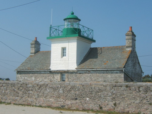
1836. Active; focal plane 11 m (36 ft); white light, occulting three times, in a 2+1 pattern, every 10 s. 10 m (33 ft) square cylindrical stone tower with lantern and gallery, rising from the center of a 1-story stone keeper's house. House unpainted, tower painted white, lantern and gallery green. A photo is at right, Trabas has Capt. Peter's photo, and Google has a great street view and a satellite view. The house appears to be a private residence. Located on the Pointe de Saire about 3 km (2 mi) east southeast of Réville. Accessible by road; parking available. Site and tower closed, but the light can be seen from outside the stone wall surrounding the station. ARLHS FRA-761; Admiralty A1442; NGA 8448.
Phare de la Pointe de Saire
Pointe de Saire Light, Réville, June 2007
Wikimedia public domain photo by Rundvald
* St.-Vaast-la-Hougue (2)
1865 (station established 1850). Active; focal plane 12 m (39 ft); white, red, or green light, depending on direction, occulting twice every 6 s. 11 m (36 ft) octagonal cylindrical cast iron tower with lantern and gallery. Fog siren (one long and one short blast every 30 s). Tower painted white, lantern and gallery red. Aydemphia Lewis has the street view seen at right, Benh Lieu Song has a nice photo, Trabas has Capt. Peter's photo, Ben Vaude has a 2022 closeup, Guyomard and Carceller have photos, Huelse has a historic postcard view, and Google has a satellite view. This is one of many cast iron tourelles prefabricated by the firm of Sautter et Lemonnier. Apparently this is the oldest survivor of its class, since the first one built, for Calais Jetée de l'Est, was swept away by a storm. Located on the end of the jetty of the new harbor of St.-Vaast-la-Hougue, on the east side of town facing l'Île de Tatihou. Accessible by walking the jetty. Site open, tower closed. ARLHS FRA-151; Admiralty A1434; NGA 8460.
Morsalines (La Hougue Feu Postérieur) (4)
1955 (station established 1836). Active; focal plane 90 m (295 ft); white, red, or green light, depending on direction, occulting four times every 12 s. 13 m (43 ft) octagonal concrete tower with an off-center lantern and gallery. Tower painted white, lantern dark green. Trabas has Capt. Peter's photo and Google has a satellite view. This range guides ships entering the protected old harbor of St.-Vaast-la-Hougue, on the east side of the Cotentin peninsula.The front light is on a square post at the shore, 3.3 km (2 mi) to the east. The original lighthouse was replaced by an 18 m (58 ft) tower in 1938; that lighthouse was destroyed in the fighting shortly after D-Day. A temporary light served until the present tower was built. This light is adjacent to a private residence, and there does not appear to be a nearby location from which it can be viewed. Located atop a high hill south of Morsalines. Site and tower closed. ARLHS FRA-365; Admiralty A1428.1; NGA 8468.

Saint-Marcouf and Brévands Lighthouses
Îles Saint-Marcouf (Île du Large) (2)
1948 (station established 1840). Active; focal plane 18 m (59 ft); three very quick white flashes every 5 s. Approx. 7 m (23 ft) square cylindrical concrete tower with lantern and gallery mounted atop a circular stone fort. Tower is unpainted, lantern painted dark green. Charles Ngando Black has a 2021 photo, Trabas has Capt. Peter's distant view, and Google has an indistinct satellite view. Huelse has a historic postcard view of the original lighthouse. The Îles Saint-Marcouf are two small islands in the Baie de la Seine about 10 km (6 mi) off Ravenoville Plage. The larger island (Île du Large) is almost completely covered by a historic fort. On D-Day in 1944 U.S. forces landed on the island unopposed before dawn; they were actually the first Alled troops to step on French soil. They found the island heavily mined and the 1840 lighthouse had been destroyed. Accessible only by boat. Site and tower closed. ARLHS FRA-055; Admiralty A1424; NGA 8472.

St.-Vaast-la-Hougue Light, St.-Vaast-la-Hougue, November 2017
Google Maps street view by Aydemphia Lewis

Département du Calvados Lighthouses

The Département du Calvados includes the long beach between the base of the Cotentin peninsula and the mouth of the Seine. This is the beach of the famous Normandy landings (D-Day), where Allied troops stormed ashore on 6 June 1944 in the largest seaborne invasion in history.

Grandcamp-Maisy and Port-en-Bessin-Huppain Lighthouses
* Grandcamp-Maisy Jetée Est (1)
1925. Originally an 8 m (26 ft) round cast iron tower, the lighthouse was largely destroyed during the D-Day fighting. A 3 m (10 ft) stump of the tower can still be seen on the jetty, as seen in A. Yannick's photo and Google's satellite view. Trabas has Capt. Peter's photo of the modern light (focal plane 9 m (30 ft); red light, occulting twice every 6 s), shown from a steel post off the end of the jetty. Midway on the jetty is the front light of the Grandcamp-Maisy Range. Google has a street view. Accessible by walking the east jetty at Grandcamp-Maisy. Site open, tower closed. ARLHS FRA-678; Admiralty A1408; NGA 8504.
* La Maresquerie
Date unknown. Active; focal plane 28 m (92 ft); white light, 3 s on, 1 s off. 12 m (39 ft) white concrete post attached to a 1-story concrete equipment shelter. Trabas has a photo and Google has a street view and a satellite view. Located on a hilltop off the Rue du Petit Maisy about 250 m (820 ft) south of the Grandcamp-Maisy harbor. Site open, tower closed. ARLHS FRA-676; Admiralty A1410; NGA 8492.
* [Port-en-Bessin Antérieur (2)]
1905 (station established 1856). Active; focal plane 25 m (82 ft); white light, occulting three times every 12 s, synchronized with the rear light. 8 m (26 ft) post. A 1-story round fog signal building, standing beside the light, is topped by a siren on a short mast. The siren sounds continuously while rotating through 180°. Trabas has Capt. Peter's photo, Guyomard and Carceller have a photo (bottom of the page), and Google has a satellite view and a closeup street view. Located atop a bluff overlooking the harbor entrance, about 10 km (6 mi) northwest of Bayeux. Site open, tower closed. ARLHS FRA-605; Admiralty A1400; NGA 8516.
* Port-en-Bessin Postérieur (2)
Date unknown (station established 1854). Active; focal plane 42 m (138 ft); white light, occulting three times every 12 s, synchronized with the front light. 12 m (40 ft) stone keeper's house. The lantern is in the center of the end of the house facing the sea; that end is covered with concrete, painted white. There is a statue of the Virgin at the peak of the house, above the lantern. Trabas has a photo by Thomas Philipp, Guyomard and Carceller have a photo, Werning has a view from the side of the building, Huelse has a historic postcard view (showing the house without the statue), Google has a street view, and the building is centered in a Google satellite view. The original lighthouse was still present in the 1930s; it was bombed and largely destroyed during the D-Day battles. In 2016 the present lighthouse was purchased by the Diocese of Bayeux. Located on the Rue du Phare overlooking the harbor entrance at Port-en-Bessin, about 10 km (6 mi) northwest of Bayeux. Site open, tower closed. Owner/site manager: Diocèse de Bayeux et Lisieux. ARLHS FRA-406; Admiralty A1400.1; NGA 8520.

Ver-sur-Mer Lighthouse
* Ver-sur-Mer (Pointe de Ver, Juno Beach) (3)
1908 (rebuilt 1950; station established 1808). Active; focal plane 42 m (138 ft); three white flashes, separated by 2.8 s, every 15 s. 16 m (53 ft) square cylindrical masonry tower with lantern and gallery, rising from 1-story keeper's house complex. Lighthouse painted white; lantern dome is unpainted gray metal. Werning's photo is at right, Trabas has a closeup by Arno Siering, another photo is available, Huelse has a historic postcard view, and Google has a street view and a satellite view. This lighthouse stood on the heights above Juno Beach during the initial D-Day assault by Canadian and other Allied forces. Though the Canadians captured the lighthouse quickly it was heavily damaged in the fighting and had to be rebuilt extensively after the end of the war. Located on the Rue du Pavillon just off the Avenue du 6 Juin in Ver-sur-Mer, about 20 km (13 mi) northwest of Caen. Site open, tower closed. . ARLHS FRA-532; FR-439000; Admiralty A1396; NGA 8532.

Pointe de Ver Light, Ver-sur-Mer
photo copyright Malte Werning; used by permission

Ouistreham Lighthouses
* Ouistreham Feu Postérieur (2)
1845 (station established 1828). Inactive since 1888. 23 m (75 ft) square Norman Gothic stone tower of the Église de Saint-Samson. B. and J. Hericourt have a 2022 photo and Google has a street view and a satellite view. The light was replaced by the Feu des Écluses, a lighthouse that was demolished after the range was deactivated in 1905. Located near the center of Ouistreham. Site open, church open, tower status unknown. ARLHS FRA-687.
*** Ouistreham
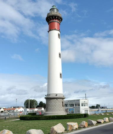
1905. Active; focal plane 37 m (121 ft); white or red light, depending on direction, 3 s on, 1 s off. 38 m (125 ft) round granite tower with lantern and gallery. The lantern, gallery, and watch room are painted red and the rest of the tower white, except the 1-story base is unpainted gray stone. 2-story stone keeper's house. A photo by Philippe Boisroux is at right, Werning has a fine photo, Trabas has Capt. Peter's closeup photo, Nel de Jong Vlaardingen has another good photo, Huelse has a historic postcard view, Marinas.com has aerial photos, and Google has a street view and a fine satellite view. This lighthouse stood at the eastern end of the beaches invaded by Allied troops on D-Day, 6 June 1944. Captured by British forces in the initial assault, it escaped destruction by the Germans. The 100th anniversary of the lighthouse was celebrated in June 2005. The lighthouse stands beside the lock at the entrance to the Canal de Caen à la Mer, which allows vessels to reach the city of Caen, 14 km (9 mi) to the south. Note: Ouistreham is pronounced "Weesstrum." Located on the Quai Georges Thierry in Ouistreham, at the mouth of the Orne River. Site open, tower open on weekends in July and August. . Site manager: Le Phare de Ouistreham. ARLHS FRA-377; FR-435000; Admiralty A1377; NGA 8552.
* Ouistreham Jetée de l'Est Feu Postérieur (2?)
Date unknown. Active; focal plane 30 m (98 ft); red light occulting four times every 12 s. 25 m (82 ft) triangular cylindrical skeletal tower. Trabas has Capt. Peter's photo and Google has a street view and a satellite view. NGA describes the tower as a "tripod." This is the entrance range for Ouistreham and the Canal de Caen à la Mer. The front light is on a post on the east jetty. Located across the street from the Ouistreham lighthouse. Site open, tower closed. Admiralty A1381.1; NGA 8572.

Ouistreham Light, Ouistreham, August 2023
Instagram photo by Philippe Boisroux

Dives-sur-Mer and Trouville-sur-Mer Lighthouses
* Dives-sur-Mer (2)
1937 (station established 1866). Inactive since 2013. 5 m (16 ft) square brick building with a pronounced A-frame roof; the light is shown through a window. Google has a street view, and the tiny lighthouse is centered in a Google satellite view. Located beside the Rue des Bains (D513) at the mouth of the Dives estuary at Dives-sur-Mer, about 30 km (19 mi) northeast of Caen. Site open, tower closed. ARLHS FRA-675; ex-Admiralty A1374; ex-NGA 8580.
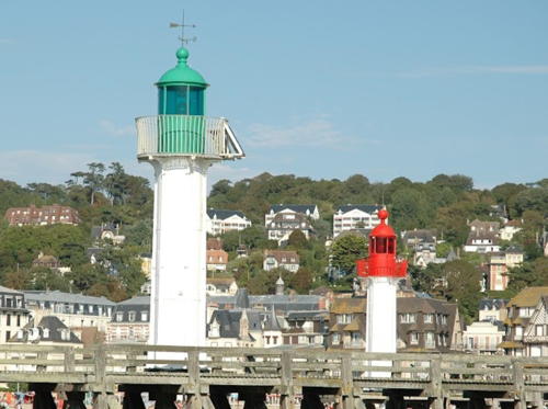
* Trouville (Deauville) Jetée de l'Ouest
1875. Active; focal plane 11 m (36 ft); quick-flashing green light. 10 m (33 ft) round cast iron tower with lantern, gallery, and six ribs. Tower painted white, lantern green. This is a rare surviving nineteenth century cast iron tourelle. Fred Leloir's photo of the jetty lights is at right, Werning has a photo, Trabas has Capt. Peter's closeup, a 2022 photo is available, Andrey Leonov has a street view, Huelse has a historic postcard view, and Google has a satellite view. This light is in the commune of Deauville; the east jetty is in Trouville. Located at the end of the jetty on the southwest side of the entrance to Trouville-sur-Mer harbor; accessible by walking the jetty. Site open, tower closed. ARLHS FRA-528; Admiralty A1284; NGA 8584.
* Trouville Jetée de l'Est (Pointe de la Cahotte feu antérieur) (3)
About 1952 (station established 1860). Active; focal plane 11 m (36 ft); red light occulting once every 4 s, synchronized with the rear light. 10 m (33 ft) round cast iron tower with lantern, gallery, and six ribs. Tower painted white, lantern red. Fred Leloir's photo of the jetty lights is at right, Werning has a good photo, Trabas has Capt. Peter's closeup, Bonin Loic has a street view, and Google has a satellite view. The 1875 lighthouse, a sibling of the west jetty light, was destroyed during World War II and replaced by a copy of the original. The jetty has been extended by a submerged rock breakwater and a new light has been placed at its end. The historic light is retained as the front light of the entrance range. Located at the end of the jetty on the northeast side of the entrance to Trouville-sur-Mer harbor; accessible by walking the jetty. Site open, tower closed. ARLHS FRA-527; Admiralty A1283; NGA 8600.

West (left) and East Jetty Lights, Trouville-sur-Mer, August 2016
Google Maps photo by Fred Leloir
* Pointe de la Cahotte (Deauville) feu postérieur (3)
1971 (station established 1875). Active; focal plane 17 m (56 ft); red light occulting once every 4 s, synchronized with the front light. 15 m (49 ft) square skeletal mast, mounted on a square equipment shelter. Lighthouse painted white. Trabas has Capt. Peter's photo and Google has a street view and a satellite view. The original lighthouse here was a square masonry tower painted with red and white horizontal bands. The lighthouse was replaced by a 14 m (46 ft) metal pylon in 1909, and the historic building was destroyed by German troops following the D-Day invasion. Located on the Quai Albert Ier at the foot of the east jetty. Site open, tower closed. ARLHS FRA-754; Admiralty A1283.1; NGA 8604.

Honfleur Lighthouses
Honfleur is a historic port on the south side of the mouth of the River Seine, directly across from Le Havre. For lighthouses of Le Havre, see the Haute-Normandie page.

* Falaise des Fonds (Le Butin)
1908. Active; focal plane 15 m (49 ft); three flashes every 12 s, white, red, or green depending on direction. 18 m (59 ft) square cylindrical stone tower with lantern and gallery. Werning's photo is at right, Trabas has a closeup, Huelse has a historic postcard view, and Google has a street view and a satellite view. The lighthouse appears to be only about 9 m (30 ft) tall but half its original height is now buried below ground level. The lantern and Fresnel lens were transferred from the L'Hôpital lighthouse (next entry) when that light was deactivated in 1908. Falaise is a cliff or bluff. Located on the D513 highway on the south side of the entrance to the Seine estuary about 1.5 km (1 mi) west of Honfleur. There is parking adjacent to the lighthouse. Site open, tower closed. ARLHS FRA-280; FR-423000; Admiralty A1290; NGA 8616.

Falaise des Fonds Light, Honfleur
photo copyright Malte Werning; used by permission
* Honfleur (Feu de l'Hôpital) (2)
1857 (station established 1792). Inactive since 1908. 25 m (82 ft) unpainted round masonry tower with gallery; lantern removed. Werning has a photo, a 2021 photo is available, Christophe Lauer has another photo, Guyomard and Carceller have several photos, Huelse has a historic postcard view of the lighthouse with its lantern, and Google has a street view and a satellite view. Built at the edge of the estuary near the hospital, the lighthouse now stands some distance from the shore, apparently because land has been filled since it was built. It was replaced by the Falaise des Fonds lighthouse in 1908. In 1886 the lighthouse was the subject of a well-known pointillist painting by Georges Seurat. Located on the D513 highway at the northwest edge of Honfleur. Site open, tower closed. . ARLHS FRA-682.
* Honfleur Jetée de l'Est (3)
1876 (station established early 1800s). Inactive since 2016. 12 m (40 ft) round cylindrical tower with lantern and gallery, mounted on a stone base. Tower painted white, lantern and gallery red. Trabas has Capt. Peter's photo of the active light (red flashing light) on a short post. Werning's photo is at right, Alban Thiery has a photo, Trabas also has a good photo, another closeup is available, and Google has a street view and a satellite view. The present lighthouse replaced an 1843 masonry tower, which is believed to have replaced an earlier light. Located at the point of the jetty, marking the entrance to the Avant Port in the old city section of Honfleur. Site open, tower closed. ARLHS FRA-103; ex-Admiralty A1294. Active light: Admiralty A1294.5.

Jetée de l'Est Light, Honfleur
photo copyright Malte Werning; used by permission

Information available on lost lighthouses:

Notable faux lighthouses:

Adjoining pages: East: Haute-Normandie | South: Northeastern Brittany | West: Guernsey, Jersey

Return to the Lighthouse Directory index | Ratings key

Posted July 6, 2006. Checked and revised November 6, 2023. Lighthouses: 50. Site copyright 2023 Russ Rowlett and the University of North Carolina at Chapel Hill.