Lighthouses of France: North Coast (Hauts-de-France)

France (officially the French Republic, République française) has coasts facing south on the Mediterranean Sea, west on the open Atlantic Ocean, and north on the English Channel (La Manche in French). Long a leader in lighthouse design, France has scores of famous and historic lighthouses. And it was a French engineer and physicist, Augustin-Jean Fresnel (1788-1837), who invented the powerful and beautiful lenses used in lighthouses around the world.

Metropolitan (European) France is divided into 13 administrative regions (régions) and the regions are divided into departments (départements). This page lists lighthouses of the northernmost part of the country, the region called Hauts-de-France ("Upper France"). The Hauts de-France region includes the three coastal départements of Somme, Pas de Calais, and Nord. The region faces the Pas de Calais (Strait of Dover) and its approaches from La Manche (the English Channel) to the west and from the North Sea to the north. The strait narrows to a width of 33 km (20 mi) at Cap Gris Nez. Before modern navigation systems were developed lighthouses were of crucial importance in protecting the heavy volume of shipping through these narrow seas.

This coastline saw fierce fighting during World War II, especially during and after the Allied D-Day invasion of June 1944; very few of the lighthouses in the area escaped damage and some were destroyed.

The French word for a lighthouse, phare, is often reserved for the larger coastal lighthouses; a smaller light or harbor light is called a feu (literally "fire," but here meaning "light") or a balise (beacon). The front light of a range (alignement) is the feu antérieur and the rear light is the feu postérieur. In French île is an island, cap is a cape, pointe is a promontory or point of land, roche is a rock, récife is a reef, baie is a bay, estuaire is an estuary or inlet, détroit is a strait, rivière is a river, and havre is a harbor.

Aids to navigation in France are maintained by the Bureau des Phares et Balises, an agency of the Direction des Affaires Maritimes (Directorate of Maritime Affairs). The Directorate has four regional offices (called Directions Interrégionale de la Mer, or DIRM) at Le Havre, Nantes, Bordeaux, and Marseille. Lights in this area are managed by the DIRM Nord-Atlantique Manche Est - Mer du Nord (DIRM-MEMN) at La Havre.

ARLHS numbers are from the ARLHS World List of Lights. FR numbers are the French light list numbers, where known. Admiralty numbers are from volume A of the Admiralty List of Lights & Fog Signals. U.S. NGA List numbers are from Publication 114.

General Sources
Phares de la DIRM MEMN
Lighthouse information from the DIRM regional office.
Les Sentinelles des Mers - France Nord
Photos and information posted by Guy Detienne.
Le Phare à travers le Monde
A large, well known site maintained by Alain Guyomard and Robert Carceller.
Online List of Lights - France North Coast
Photos by various photographers posted by Alexander Trabas. Many of the photos for France are by Arno Siering or by Capt. Peter Mosselberger ("Capt. Peter").
Phareland, le Site des Phares de France
This comprehensive site has good photos and information about the major lighthouses.
Leuchttürme.net - Frankreich - Nord, Pas de Calais, Picardie
Photos and notes by Malte Werning.
Lighthouses of France
Excellent photos by Marc de Kleijn.
Lighthouses in Hauts-de-France
Photos by various photographers available from Wikimedia.
France Lighthouses
Aerial photos posted by Marinas.com.
Société Nationale pour le Patrimoine des Phares et Balises (S.N.P.B.)
The French national lighthouse preservation organization.
Französische Leuchttürme
Historic photos and postcard images posted by Klaus Huelse.
GPSNavigationCharts
Navigational chart information for northern France.
Navionics Charts
Navigational chart for La Manche and the Pas de Calais.
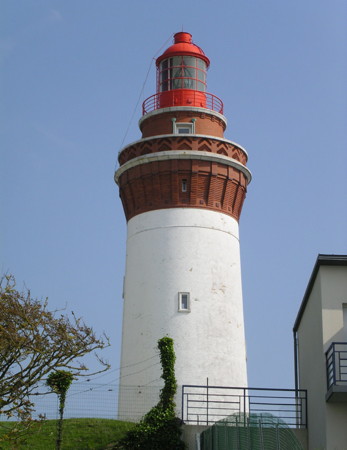
Phare d'Ault
Ault Light, Ault, Somme
photo copyright Arno Siering; used by permission
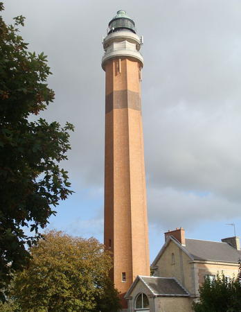

La Canche Light, Le Touquet, Pas de Calais, September 2010
Wikimedia Creative Commons photo by Marie-Jo L.
Département de la Somme Lighthouses

Abbeville Arrondissement Lighthouses
Ault (2)
1951 (station established 1887; inactive 1940-1951). Active; focal plane 95 m (312 ft); white or red light, depending on direction, occulting three times every 12 s. 28 m (92 ft) round tower with lantern and triple gallery. The lower 2/3 of the tower is white reinforced concrete; upper portion is red brick. Lantern and upper gallery painted red. 2-story keeper's house. Designed by Georges Martin, architect. DIRM has a page for the lighthouse, Trabas has a good photo by Siering (also seen above), Nathalie Hupin has a nice photo, a closeup is available, Marinas.com has aerial photos, and Google has a street view and a satellite view. Detienne also has a page for the original lighthouse, a sturdy brick tower, and Huelse has a postcard view. It was blown up by retreating French forces on 16 June 1940. Located on the Boulevard du Phare in the village of Ault, about 16 km (7.5 mi) north of Eu. Site and tower closed (the station is located on a military reservation); the lighthouse can be viewed from a distance. . ARLHS FRA-175; Admiralty A1220; NGA 8800.
* Cayeux-sur-Mer (Brighton) (3)
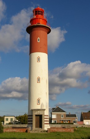
1951 (station established in the 1770s; inactive 1940-1951). Active; focal plane 32 m (105 ft); red flash every 5 s. 32 m (105 ft) round masonry tower with lantern and double gallery. Upper half of the lighthouse, including the lantern, painted red, lower half white. 2-story brick keeper's house adjacent. Lighthouse designed by Cahon et Barrère, architects. A photo is at right, Trabas has Siering's photo, a 2022 photo is available, Marinas.com has aerial photos, and Google has a street view and a satellite view. Detienne has a page for the 1835 lighthouse, a 27 m (89 ft) tower centered on a 1-story keeper's house, and Huelse has a postcard view. It was blown up by German troops on 31 August 1944. Located on the clifftop Route Blanche in the village of Brighton, 2 km (1.25 mi) northeast of Cayeux-sur-Mer and about 20 km (13 mi) west of St.-Valery-sur-Somme. Site open, tower closed. . ARLHS FRA-232; Admiralty A1208; NGA 8804.
* Le Hourdel (3)
1948 (station established 1840; inactive 1940-1948). Active; focal plane 19 m (62 ft); white or green light, depending on direction, occulting three times every 12 s. 18 m (59 ft) round cylindrical white reinforced concrete tower with gallery but no lantern, attached to a small 1-story semi-elliptical keeper's house. Brigitte Chanson has a good photo, Trabas has an excellent photo by Siering, Guyomard and Carceller also have two photos, Rik Helsen has a 2023 photo, Michel Forand has a historic photo, and Google has a street view and a satellite view. This unusual modern tower was designed by Cahon et Barrère, architects. The original 10 m (33 ft) mast light was replaced in 1905 by a cast iron tower of the same height; that lighthouse, like so many others on this coast, was destroyed during World War II. Located at the end of the Route Blanche at the south side of the entrance to the Somme, about 8 km (5 mi) northeast of Cayeux-sur-Mer. Site open, tower closed. . ARLHS FRA-318; Admiralty A1210; NGA 8808.
* La Ferté (Saint-Valéry sur Somme)
Date unknown. Active; focal plane 9 m (30 ft); red flash every 4 s. 6 m (20 ft) post rising from a square 1-story equipment shelter. Lighthouse painted white with a red top. Trabas has Capt. Peter's photo and Google has a street view and a satellite view. Located on an earthen breakwater on the east side of the River Somme opposite Saint-Valéry sur Somme. Site open, tower closed. Admiralty A1216; NGA 8824.
Phare de Cayeux-sur-Mer
Cayeux-sur Mer Light, Cayeux-sur Mer, August 2008
Flickr Creative Commons photo by mikou07kougou
* Le Crotoy (2)
1948 (station established 1851). Active; focal plane 19 m (62 ft); red light occulting twice every 6 s. 11 m (36 ft) concrete tripod tower with gallery. The tower is unpainted; gallery painted red. Trabas has a photo, Andreas Köhler has a 2018 photo, and Google has a street view and a satellite view. Located in a small park at the foot of the Rue du Phare in Le Crotoy, on the north side of the entrance to the Somme. Site open, tower closed. ARLHS FRA-349; Admiralty A1211; NGA 8812.

Département du Pas de Calais (Strait of Dover) Lighthouses

The coast in Pas de Calais and Nord is called the Côte d'Opale, a name coined in 1911 by the painter and author Édouard Lévêque.

Montreuil Arrondissement Lighthouses
* Berck (3)
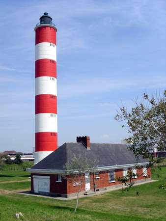
1951 (station established 1836; inactive 1940-1951). Active; focal plane 44 m (144 ft); white flash every 5 s. 45 m (147 ft) round cylindrical concrete block tower with lantern and gallery attached to 1-story modern brick keeper's house. Tower painted with red and white horizontal bands, lantern painted black. Trabas has a fine photo of the station by Siering (also seen at right), Domicent Marchand has a good photo, Wikimedia has photos, Phareland also has many photos, Maya Bringel has a 2023 closeup, Marinas.com has aerial photos, and Google has a street view and a satellite view. The original lighthouse rose through the center of the keeper's house; when a larger building nearby obstructed its light, a 25 m (82 ft) tower was added in 1868 at the end of the building. These towers were destroyed by retreating German forces in August 1944. Detienne has a page for the first two lighthouses and Huelse has a postcard view showing both of them. Located on the Pointe du Haut-Banc in Berck. Site open, tower closed. . ARLHS FRA-159; Admiralty A1202; NGA 8828.
** La Canche (Le Touquet) (3)
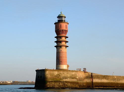
1951 (station established 1801; inactive 1940-1951). Active; focal plane 55 m (180 ft); two white flashes every 10 s. 56 m (184 ft) round brick tower with lantern and double gallery. Tower is unpainted red-orange brick except for a single brown horizontal band that is probably darker brick; lantern, watch room, and galleries painted white. 2-story stone keeper's house. A photo is at the top of this page, a 2019 photo of this very handsome modern lighthouse is available, Trabas has Capt. Peter's photo, Werning has a photo, Bram van Damme has a late 2007 closeup, Marinas.com has distant aerial photos, and Google has a street view and a satellite view. The light station, marking the entrance to the Rivière de la Canche, was established with twin towers in 1801. The second pair of lighthouses, built in 1852 and 54 m (177 ft) tall, stood until they were destroyed by retreating German forces in September 1944. A temporary light was shown from the belfry of the Hôtel de Ville (city hall) from October 1944 until the new tower, designed by Louis Quételard, was completed in 1951. Long open for climbing, the present tower was closed in 1993 due to security and safety concerns. In August 2009 it was announced that the lighthouse would reopen in summer 2010. Located on the Avenue des Phares in Le Touquet-Paris-Plage, a beach resort town about 8 km (5 mi) west of Étaples. Site open, tower open to guided tours on Saturdays and other selected dates. Site manager: Phare de la Canche . ARLHS FRA-209; Admiralty A1196; NGA 8832.
[Camiers (Armand, Lornel) (5)]
Date unknown (station established 1805). Active; focal plane 17 m (56 ft); white, red or green light, depending on direction, occulting twice every 6 s. 11 m (36 ft) post with gallery, painted red. Recently damaged; Trabas has Capt. Peter's photo showing the light overturned. Google has a satellite view. This directional light guides vessels approaching the Canche estuary. The station has a complex history due to changes in the channel over the years. The original masonry lighthouse was replaced by a pair of range lights in 1874 and then by a directional light in 1891. That light was destroyed in World War II and replaced first by a skeletal tower and then by the present light. Located on the dunes on the north side of the Canche, east of Camiers. Site open, tower closed. Site manager: Réserve Naturelle de la Baie de Canche. ARLHS FRA-768; Admiralty A1194; NGA 8840.
Phare de Berck
Berck Light, Berck
photo copyright Arno Siering; used by permission

Boulogne-Sur-Mer Arrondissement Lighthouses
A city of about 45,000 residents, Boulogne-sur-Mer is France's largest fishing port.

*
Cap d'Alprech (3)
1962 (station established 1830; inactive 1940-1962). Active; focal plane 62 m (203 ft); three white flashes, separated by 3 s, every 15 s. 17 m fluted cylindrical steel post, with lantern, gallery, and an external stairway spiraling gracefully around the tower. Tower painted white, lantern and gallery black. Ian Fahsi has a 2021 photo, Werning has a good photo, Trabas has a closeup by Thomas Philipp, Wikimedia has a photo, Phareland has many photos, and Google has a street view and a satellite view. This is a good candidate for the title of the world's most beautiful post light. Huelse has a historic postcard view of the 1842 lighthouse; a square masonry tower with keeper's house, it was destroyed by German troops in 1942 because it stood in the line of fire of their coastal artillery. This is the landfall light for Boulogne, located on a promontory at the end of the Rue du Cap about 3 km (2 mi) southwest of the city. Site open, tower closed. . ARLHS FRA-158; Admiralty A1190; NGA 8844.
* Boulogne Digue Sud (Digue Carnot) (2)
1924 (station established 1887). Active; focal plane 25 m (82 ft); three white flashes, in a 2+1 pattern, every 15 s. 22 m (72 ft) round cylindrical tower with lantern and gallery. Tower painted white, lantern green. Fog horn (three blasts, in a 2+1 patterm, every 60 s). Werning has a photo, Trabas has a photo by Capt. Peter, J.J.W. d'Artois has a 2023 photo, and Bing has a satellite view. The Digue Carnot is a long south-to-north breakwater that shelters the modern harbor of Boulogne. It is possible to walk the breakwater (many fishermen do); Guyomard and Carceller have a series of photos by Jacques Conreux. Site open, tower closed. ARLHS FRA-204; Admiralty A1170; NGA 8860.
* Boulogne Jetée Sud-Ouest (7)
1999 (station established 1817). Active; focal plane 11 m (36 ft); continuous green light. 10 m (33 ft) round cylindrical fiberglass tower with lantern and gallery. Entire structure painted green. Werning has a good photo, Trabas has Capt. Peter's photo, Guyomard and Carceller have a photo by Jean-Michel Penin, and Google has a satellite view and a distant street view of the two jetty lights. This station had three different towers before 1903. Klaus Huelse has posted a postcard view of the 1903 cast iron tower, which rose through the center of a signal station building. Another replacement tower was built in 1928. The Germans demolished the 1928 lighthouse during World War II and replaced it with a concrete blockhouse; after the war a light was placed on a mast atop the blockhouse. In 1999 the blockhouse was removed and the present tower, a fiberglass copy of the 1928 lighthouse, was installed. Located on the southwest jetty at the entrance to the old harbor of Boulogne. Accessible by walking the jetty. Site open, tower closed. ARLHS FRA-089; Admiralty A1180; NGA 8888.
* Boulogne Jetée Nord-Est (5)
1928 (station established 1817). Active; focal plane 11 m (36 ft); continuous red light. 10 m (33 ft) round cylindrical cast iron tourelle with lantern and gallery. Entire lighthouse painted red. A good photo and a 2008 closeup are available, Trabas has Capt. Peter's photo, Guyomard and Carceller have a photo by Jean-Michel Penin, Huelse has a postcard view of the present tower, and Google has a satellite view and a distant street view of the two jetty lights. Like the northeast jetty light, this lighthouse was replaced twice before 1903, when the first cast iron tower was placed at the end of a rebuilt pier. Located on the northeast jetty at the entrance to the old harbor of Boulogne. Accessible by walking the jetty. Site open, tower closed. . ARLHS FRA-054; Admiralty A1178; NGA 8892.
* Cap Gris Nez (3)
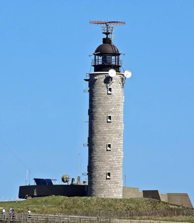
1958 (station established 1837). Active; focal plane 72 m (236 ft); white flash every 5 s. 31 m (102 ft) round cylindrical concrete block tower with lantern and gallery. Tower is unpainted gray blocks, lantern painted black. 1-story modern vessel traffic control center. A photo by Joel Herbez is at right, Trabas has a good photo of the light station by Capt. Peter, Graça Bussy has a 2021 photo, Patrick Demory has a good 2008 photo, Werning has a good photo, Marinas.com has aerial photos, and Google has a street view and a satellite view. Detienne has a page for the original lighthouse, a round cylindrical brick tower, and Huelse has a postcard view. The old lighthouse was raised from 14 m (46 ft) to 24 m (79 ft) in 1861. Destroyed by war in 1944, it was replaced by a temporary tower in 1946 and then by the present lighthouse in 1958. On clear days the famous white cliffs of Dover, England, can be seen from the headland of Cap Griz Nez. This area was heavily fortified by the Germans during World War II; a nearby museum displays artifacts from the fortifications. The area has been incorporated into a regional nature park. Located on the cape, the southwestern entrance to the Pas de Calais (Strait of Dover), in Audinghen, about 25 km (15 mi) southwest of Calais. Site open, parking provided; tower closed. Site manager: Parc naturel régional des Caps et Marais d'Opale. . ARLHS FRA-086; Admiralty A1166; NGA 8896.

Cap Gris-Nez Light, Audinghen, April 2015
Wikimedia Creative Commons photo by Joel Herbez

Calais Arrondissement Lighthouses
Calais has a metropolitan population of about 150,000. The closest French city to England, it is the traditional ferry port for crossings of the English Channel to Dover.
* Sangatte
Date unknown. Active; focal plane 13 m (43 ft); white or green light, depending on direction, occulting once every 4 s. 8 m (26 ft) post carrying a radar antenna and mounted on a 1-story brick building. Upper half of the post painted green, lower half white. Trabas has Capt. Peter's closeup photo and Google has a street view and a satellite view. This light acts as a leading light for ships crossing the Channel from England. Located on the beachfront at Sangatte, about 2.5 km (1.5 mi) west of Calais. Site open, tower closed. Admiralty A1160; NGA 8900.
* Calais Jetée de l'Ouest (4)
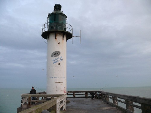
About 1952 (station established 1842). Active; focal plane 12 m (39 ft); green light, 1.5 s on, 1.5 s off. 12 m (39 ft) round cylindrical cast iron tower with lantern and gallery. Tower painted white, lantern and gallery dark green. Fog bell (stroke every 5 s). A photo is at right, Trabas has a good closeup photo by Capt. Peter, Chris Warner has a closeup street view, Lorenzo Strada has a 2021 photo, and Google has a satellite view. Huelse has posted a historic postcard view of the 1903 lighthouse, a typical cast iron tourelle, which was destroyed during World War II. The earlier lighthouse was relocated in 1925, when the jetty was demolished and rebuilt about 100 m (110 yd) to the west. Located at the end of the west jetty of Calais harbor; accessible by walking the jetty. Site open, tower closed. ARLHS FRA-156; Admiralty A1148; NGA 8912.
* Calais Gare Maritime
Date unknown. Inactive since 2011 (?); charted with a white light by Navionics. Square skeletal tower with gallery and a radar antenna, mounted on the seaward corner of a wedge-shaped 4-story harbor control building. Light tower painted red, building gray. Vittorio Epifani has a 2017 photo and Google has a street view and a satellite view. The original red leading light was dropped by the Admiralty and NGA in 2011, but apparently a weaker white light is displayed now. Located on the Quai de la Marée, the terminal for P&O Ferries arriving from Dover, England. Site open, tower closed. ex-Admiralty A1158; ex-NGA 8905.

Jetée de l'Ouest Light, Calais, January 2007
Flickr Creative Commons photo by Lynne Hand
* Tour du Guet
1818. Inactive as a lighthouse since 1848 but the tower is partially illuminated at night. 35 m (115 ft) 2-stage square medieval stone tower with two galleries; the lower stage is supported by four massive arched pillars. French Wikipedia has a page with a photo, Detienne has a page for the tower, Zoe Rimmer has a 2008 closeup, and Google has a street view and a satellite view. The Tour du Guet was built sometime in the 13th century; its exact origins have been lost. Sentries watched from the tower for signs of British raiders or invaders. In 1818 the tower was placed in service as a lighthouse, but the light was deactivated when the current lighthouse was completed in 1848. The lantern was retained long enough to appear in the postcard view posted by Huelse. The tower was declared a national monument in 1931. Located in the center of the old town of Calais. Site open, tower closed (the interior is considered unsafe for public visits). . ARLHS FRA-514.
**** Calais
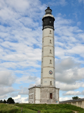
1848. Active; focal plane 59 m (194 ft); four white flashes every 15 s. 51 m (167 ft) octagonal brick tower with lantern and gallery, attached to a 2-story brick keeper's house. Lighthouse painted white, lantern and watch room black, gallery rail white. A photo appears at right, Trabas has a photo by Capt. Peter, Werning has a good photo, Wikimedia has several photos, Harald Farstad has a fine 2022 photo, and Google has a street view and a fine satellite view. Huelse has posted a prewar postcard view in which the tower is unpainted. Somehow this historic lighthouse escaped major damage in both World Wars. In 1992 the exterior was restored by replacing the original and badly weathered outer layer of bricks. Located in the center of Calais, overlooking the harbor. Site open, tower open for guided tours June through September and on Wednesdays, Saturdays, Sundays, and school holidays the rest of the year. Site manager: Phare de Calais . ARLHS FRA-004; Admiralty A1144; NGA 8904.
* Calais Jetée de l'Est (5)
1957 (station established 1801). Active; focal plane 12 m (39 ft); two red flashes every 6 s. 10 m (33 ft) round cylindrical cast iron tower with lantern and gallery, attached to a 1-story service building. All of the tower but the lantern has been enclosed in gray concrete. Lantern formerly painted red but it is white in a 2021 photo by Pascal Brachais. Fog horn (two 2 s blasts every 40 s). Guyomard and Carceller have a photo by Yves Connes, Werning has a good photo, Trabas has a closeup photo by Capt. Peter, another good photo is available, Jérôme Weber has a distant street view, and Google has a satellite view. Michel Forand has a postcard view of the fourth (1896) lighthouse, built to replace an 1864 cast iron tower that was swept away by a storm in December 1893. Located at the end of the east jetty of Calais harbor; accessible by walking the jetty. Site open, tower closed. ARLHS FRA-134; Admiralty A1146; NGA 8908.

Calais Light, Calais, June 2012
Wikimedia Creative Commons photo
by Nilfanion
Walde
1859. Inactive since 2001. Approx. 12 m (39 ft) hexagonal screwpile wrought iron skeletal tower topped by a 1-story hexagonal keeper's quarters. The original lantern was destroyed in a propane gas explosion in 1953; the replacement lantern was removed in 1986 and is now on display at the port captain's office in Boulogne-sur-Mer. French Wikimedia has an article with a good photo, a 2021 photo is available, Jade Bourguignon has a 2019 photo, Matthias Hartmann has a street view from the beach, and Google has a satellite view. Michel Forand has a drawing of the plan for the lighthouse, which was prefabricated in England. This lighthouse, the only surviving French screwpile lighthouse, is gravely endangered. When the solar-powered light was deactivated in 2001 the Service Maritime des Ports de Boulogne-sur-Mer et de Calais proposed to demolish the tower, leading to public protests. A preservation group, the Fédération Nord-Pas-de-Calais pour la Culture et le Patrimoine Maritimes, has been attempting to find funding to dismantle the tower for reassembly and display onshore. Located on a sandbar about 1 km (0.6 mi) offshore about 6 km (4 mi) east of Calais harbor. Accessible only by boat. Site and tower closed. ARLHS FRA-257.

Département du Nord (North Sea) Lighthouses

Dunkerque Arrondissement Lighthouses
* Gravelines Jetée Ouest
Date unknown. Active; focal plane 9 m (30 ft); two flashes every 6 s, white or green depending on direction. 6 m (20 ft) round unpainted brick tower carrying a green lantern structure. Pascal De Angelis has a 2021 closeup photo, Trabas has a photo, and Google has a satellite view. Located on the west breakwater of narrow dredged channel leading to Gravelines. Accessible by walking the pier. Site open, tower closed. ARLHS FRA-563; Admiralty A1132; NGA 8928.
* Gravelines Jetée Est
Date unknown. Active; focal plane 9 m (30 ft); three red flashes every 12 s. 6 m (20 ft) round unpainted brick tower carrying a red lantern structure. Thomas Gineste has a 2021 photo, Trabas has a photo, and Google has a satellite view. Located on the east breakwater of narrow dredged channel leading to Gravelines. Accessible by walking the pier. Site open, tower closed. ARLHS FRA-157; Admiralty A1132.2; NGA 8924.
* Gravelines (Petit Fort Philippe)
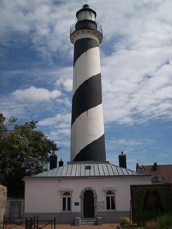
1843. Inactive since 1989. 27 m (89 ft) round brick tower with lantern and gallery, rising from the center of a 1-story keepers house. Tower painted in a black and white spiral pattern; lantern and gallery painted black. Stuart Hedges's photo is at right, Anne Breem has a 2021 photo, Marc de Kleijn has a closeup, Phareland has a page of photos, French Wikipedia has an article with a photo, and Google has a street view and a satellite view. The lighthouse was unpainted until it was restored in 1949, repairing the damage of World War II. The subject of a well-known painting by Nicolas de Stael, the Phare de Gravelines was opened to the public in June 2005. A major restoration in 2021-22 is restoring the tower and the keeper's house, which will become a museum; completion is scheduled for summer 2022. Located near the foot of the east jetty at the entrance to the Aa River in Petit Fort Philippe, north of Gravelines. Site open, tower closed in 2021 but should reopen during the 2022 season. Owner/site manager: Ville de Gravelines (Le Phare de Petit-Fort-Philippe). . ARLHS FRA-751.
* Dunkerque Ouest Jetée du Dyck
Date unknown. Active; focal plane 24 m (79 ft); four green flashes every 15 s. 23 m (76 ft) narrow round cylindrical tower with a small gallery but no lantern. Tower painted white with a green upper portion. Trabas has Capt. Peter's photo, Slawomir Purzycki has a view from the sea, and Google has a satellite view. The Jetée du Dyck is the western of two breakwaters sheltering the modern harbor (Nouveau Port) of Dunkerque. Located at the end of the jetty; accessible by walking the breakwater. Site open, tower closed. Site manager: Port de Dunkerque. ARLHS FRA-731; Admiralty A1127; NGA 8956.
* Dunkerque Ouest Jetée du Clipon
Date unknown. Active; focal plane 24 m (79 ft); four red flashes every 15 s. 23 m (76 ft) narrow round cylindrical tower with a small gallery but no lantern. Tower painted white with a red upper portion. Trabas has Capt. Peter's photo, Andrzej Cyganiuk has a view from the sea, and Google has a satellite view. The Jetée du Clipon is the eastern of two breakwaters sheltering the modern harbor (Nouveau Port) of Dunkerque. The jetty is such a popular site for birding that there is a society of birders dedicated to observations there. Located at the end of the jetty; accessible by walking the breakwater. Site open, tower closed. Site manager: Port de Dunkerque. ARLHS FRA-730; Admiralty A1127.4; NGA 8960.
Dunkerque Ouest Avant-Port Feu Antérieur
Date unknown. Active; focal plane 16 m (52 ft); continuous green light, intensified on the range line. 9 m (29 ft) steel post with lantern and gallery. Tower painted white, lantern and gallery green. Trabas has Thomas Philipp's photo and Google has a satellite view. This range guides ships though the channel between the Jetées du Clipon and du Dyck to enter the modern harbor (Nouveau Port or Avant-Port) of Dunkerque. Located on the Route de la Jetée du Clipon on the east side of the Avant-Port. Site and tower closed (harbor area is restricted). Site manager: Port de Dunkerque. ARLHS FRA-850; Admiralty A1126; NGA 8948.

Gravelines Light, Petit Fort Philippe, July 2007
Flickr Creative Commons photo by Stuart Hedges
Dunkerque Ouest Avant-Port Feu Postérieur
Date unknown. Active; focal plane 30 m (98 ft); continuous green light, intensified on the range line. 19 m (63 ft) narrow round cylindrical tower with lantern and gallery. Lighthouse painted with green and white horizontal bands. Trabas has a photo and Google has a good satellite view and a distant street view. This range guides ships though the channel between the Jetées du Clipon and du Dyck to enter the modern harbor (Nouveau Port) of Dunkerque. Located off the Route des Dunes, 600 m (0.4 mi) east southeast of the front light. Site and tower closed (harbor area is restricted). Site manager: Port de Dunkerque. ARLHS FRA-732; Admiralty A1126.1; NGA 8952.
* Dunkerque Jetée Ouest (Feu de Saint-Pol) (4)
1939 (Gustave Umbdenstock). Station established 1819. Active; focal plane 35 m (115 ft); two green flashes every 6 s. 36 m (118 ft) round Art Deco brick tower with lantern and gallery. Originally painted white below the expanded watch room, the tower is now unpainted red-brown brick; lantern black with a green copper dome. Franz-Josef Molitor's photo is at right, David Cappelaere has a good photo, Trabas has a photo by Capt. Peter, Huelse has a historic postcard view, and Google has a satellite view and a distant street view. Michel Forand has a postcard view of the third (1879) lighthouse, a cast iron tourelle. The lighthouse is nicknamed for the city's neighboring district of Saint-Pol. From 1845 to 1963 the jetty light also served as the front light of the Leughenaer Range guiding ships toward the harbor. After automation in 1979 this architecturally significant building was allowed to deteriorate until, in the 1990s, the government announced plans to replace it with a skeletal tower. A friends group was organized to fight this plan and in 1996 the lighthouse was instead recognized as a historical monument and protected, although little was done to restore the tower. An exterior restoration is scheduled for 2023 thanks to a grant from the Ministère de la Mer. Located at the end of the west jetty at the entrance to Dunkerque harbor. Accessible by walking the pier. Site open, tower closed. There are also good views from ferries crossing between Dunkerque and Dover. Owner/site manager: Communauté Urbaine de Dunkerque. . ARLHS FRA-727; Admiralty A1118; NGA 8992.

Feu de Saint-Pol, Dunkerque, July 2014
Wikimedia Creative Commons photo by Franz-Josef Molitor
[Dunkerque Jetée Est] (3)
Date unknown (station established 1863). Active; focal plane 12 m (39 ft); two red flashes every 10 s. 8 m (26 ft) concrete post with a red top. Trabas has Capt. Peter's photo and Google has a satellite view. Michel Forand has a postcard view of the second (1898) light. Located at the end of the detached extension of the east jetty at the entrance to Dunkerque harbor. Accessible only by boat. Site and tower closed. ARLHS FRA-557; Admiralty A1116; NGA 8996.
** Lightship BF-6 Sandettié
1949 (Forges & Chantiers de la Méditerranée, Le Havre). Decommissioned 1989. 47.5 m (156 ft) steel lightship; cylindrical light tower with lantern. Vessel painted red. A fine 2017 photo is available, Alejandra Jarillo has a closeup, and Google has a street view and an excellent satellite view. This was the last French lightship in service when it was retired on 3 June 1989 from the Sandettié station off Calais. (The station is now maintained by a British lightship.) The ship, one of only two surviving French lightships, was declared a national monument in 1997. Moored at the port museum at 9 Quai de la Citadelle in Dunkerque. Site open, guided tours of the ship available on Sundays April through November and daily in July and August; also open to group tours by reservation. Owner: Communauté Urbaine de Dunkerque. Site manager: Musée maritime et portuaire de Dunkerque. . ARLHS FRA-590; ex-Admiralty A0994.
* Leughenaer (Feu Postérieur)
1825. Inactive since 1963. 26 m (85 ft) octagonal brick tower with lantern. Detienne has a page for the tower. H. Willox has a photo, French Wikipedia has an article with a good photo, Huelse has a historic postcard view, and Google has a street view and a satellite view. This historic tower was built in 1548 as part of the defenses of Dunkerque. It is the only survivor of a series of towers built around the city. There is some uncertainty over the origin of its name, which means "liar's tower." Located on the Place du Minck, on the Quai des Américains in downtown Dunkerque. Site open, tower status unknown. . ARLHS FRA-752.
** Dunkerque (Risban)
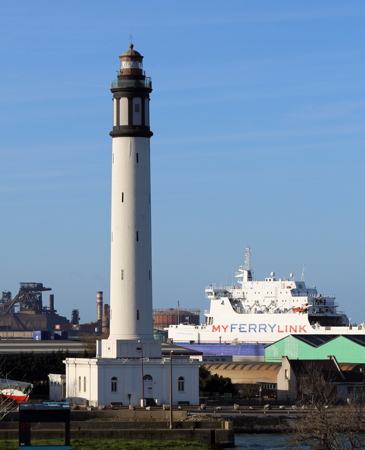
1843. Active; focal plane 59 m (194 ft); two white flashes, separated by 2.4 s, every 10 s. 56 m (184 ft) round brick tower with lantern and gallery, centered on a square 1-story brick building. Original 1st order Fresnel lens in use. Lighthouse painted white, lantern brown, gallery black; the watch room is also painted with vertical black stripes. Marc Ryckaert's 2015 photo is at right, a 2021 photo is available, DIRM has a page for the lighthouse, Guyomard and Carceller have a good photo and additional information, Trabas has a good photo by Siering, Wikimedia has photos, Huelse has a historic postcard view, Marinas.com has aerial photos, and Google has a street view and a satellite view. This magnificent building is France's tallest brick lighthouse and one of the tallest brick lighthouses in the world. The lighthouse was built atop the ruins of the Risban, a fort built in the 1680s. The lighthouse was repaired in 1992 and a more complete restoration was completed in 2002. It is managed now by the Dunkerque port museum. Located on the Route de l'Écluse Watier on the west side of the entrance to the traditional harbor in Dunkerque. Site open; tower open Sunday afternoons in July and August, also open to group tours by reservation year round. There are also good views from ferries crossing between Dunkerque and Dover. Site manager: Musée portuaire de Dunkerque. . ARLHS FRA-537; Admiralty A1114; NGA 8964.

Dunkerque Light, Dunkerque, January 2015
Wikimedia Creative Commons photo by Marc Ryckaert

Information available on lost lighthouses:

Notable faux lighthouses:

Adjoining pages: North: Southeast England | East: Belgium | West: Haute-Normandie

Return to the Lighthouse Directory index | Ratings key

Posted July 6, 2006. Checked and revised November 19, 2023. Lighthouses: 29; lightships: 1. Site copyright 2023 Russ Rowlett and the University of North Carolina at Chapel Hill.