Lighthouses of Guernsey

The Bailiwick of Guernsey is a self-governing British Crown Dependency in the Channel Islands, located just west of France's Cotentin Peninsula on the south side of the English Channel. The territory is not part of the United Kingdom although Guernsey recognizes the British monarch as its head of state, its citizens are recognized as British nationals, and Britain is responsible for its defence. The principal islands of the bailiwick are Guernsey, Alderney, and Sark.

The islands are popular tourist destinations accessible by air (except for Sark) or by ferries from several ports in England and in France. Ferries also operate between the islands.

Trinity House, the British lighthouse corporation, operates several of the major lighthouses, the others being operated by the Guernsey Harbour Authority. Special thanks to Mr. Peter Gill, the Guernsey Harbour Master, for correcting a number of errors concerning these lights.

ARLHS numbers are from the ARLHS World List of Lights. Admiralty numbers are from Volume A of the Admiralty List of Lights & Fog Signals. U.S. NGA numbers are from Publication 114.

General Sources
Trinity House
Chartered by Henry VIII in 1514, Trinity House has built and operated lighthouses in Britain for more than 500 years.
Online List of Lights - Channel Islands
Photos by various photographers posted by Alexander Trabas. Many photos for the islands were contributed by Capt. Peter Mosselberger ("Capt. Peter").
Phares d'Europe
Photos posted by Robert Carceller and Alain Guyomard as part of their Phares du Monde web site.
Lighthouses in Guernsey
ARLHS listing for Guernsey; amateur radio operators have provided photos of many of the lights.
Lighthouses in Guernsey
Photos by various photographers available from Wikimedia.
World of Lighthouses - British Territories in Europe
Photos by various photographers available from Lightphotos.net.
Luechtürme auf Briefmarken
Lighthouse postage stamps from around the world, including many of the Channel Islands lighthouses, posted by Klaus Huelse. Huelse also has a page of historic postcard views, Britische Leuchttürme auf historischen Postkarten.
GPSNavigationCharts
Navigation chart information for Guernsey.
Navionics Charts
Navigation chart information for Guernsey.


Alderney Light, Alderney, December 2022
Instagram photo by keimpartnerindonesia
Isle of Guernsey Lighthouses

Les Hanois Lighthouse
Les Hanois
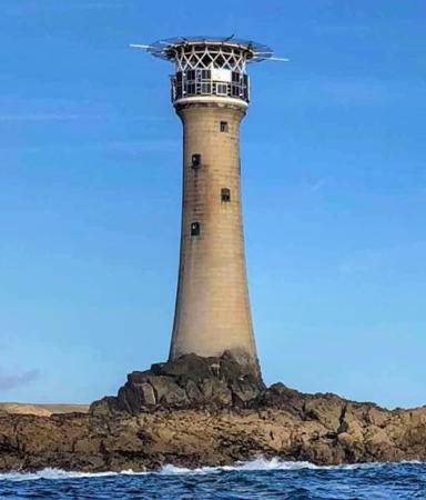
1862 (James Douglass). Active; focal plane 34 m (110 ft); two white flashes, separated by 3.2 s, every 13 s. 36 m (177 ft) tapered round granite tower incorporating keeper's quarters, with lantern, gallery, and a helipad above the lantern. Lighthouse painted white. Fog horn (2 blasts every 60 s). A Trinity House photo is at right, Trabas has Darlene Chisholm's photo, Renaut de Garis has a 2021 photo, Daniel Grubiak has a 2018 view, Karen Millard has a photo, and Google has a satellite view. The lighthouse was the first to be built with granite blocks interlocking both laterally and vertically, a design by James Douglass that became the standard for waveswept towers. In 2015 stainless steel anchors were installed to stabilize the landing steps leading to the tower. Located on a rocky reef off the southwestern point of the island, marking the westernmost point of the Channel Islands. Accessible only by helicopter, but visible from many points on land. Site and tower closed. Operator: Trinity House. . ARLHS GUE-001; Admiralty A1580; NGA 8180.

Northeast Approach Lighthouses
The lights in this group guide vessels in the narrow passage between the east coast of Guernsey and the reefs surrounding the smaller island of Herm.

Platte Fougère
1910. Active; focal plane 25 m (82 ft) (?); one long (1.3 s) flash, white or red depending on direction, every 10 s. 25 m (82 ft) octagonal cylindrical concrete tower, painted white with one black horizontal band. No lantern. Fog horn (blast every 45 s). Kevin Lajoie has a closeup photo, Trabas has Capt. Peter's photo of the lighthouse being repainted, Huelse has a historic postcard view, and Google has a satellite view. The lighthouse was restored in 1999. The NGA gives the focal plane as 15 m (50 ft); this appears to be a typo. Located about 2 km (1.2 mi) off the northeastern point of the island. Accessible only by boat, but visible from land at Fort Doyle. Site and tower closed. Operator: Guernsey Harbour Authority. ARLHS GUE-006; Admiralty A1548; NGA 8184.

Les Hanois Light, Guernsey, 2008
Trinity House photo
Tautenay
Date unknown (tower built in 1872). Active; focal plane 7 m (23 ft); three quick flashes, white or red depending on direction, every 6 s. 8 m (26 ft) round stone tower, painted with black and white vertical stripes. Trabas has Capt. Peter's photo and Google has a satellite view. This is a nineteenth century daybeacon fitted with a modern light. Located about 5 km (3 mi) east of the northeastern point of the island. Accessible only by boat. Site and tower closed. Operator: Guernsey Harbour Authority. ARLHS GUE-013; Admiralty A1548.5; NGA 8188.
Roustel (Little Russel) (2)
1970 (station established 1923). Active; focal plane 10 m (33 ft); quick-flashing white light. 8 m (26 ft) triangular steel skeletal tower mounted on a concrete base. Base painted in a black and white checkered pattern; the tower carries a black vertically slatted daymark. The tower is pushed over at a 45° angle in Trabas's photo by Capt. Peter, it is upright in a 2008 photo, and Google has a satellite view. The base is from the original lighthouse, a concrete tower demolished by a collision with the MV Winchester in February 1970. Located on a rock off the island of Herm, in the center of the channel between Herm and Guernsey. Accessible only by boat. Site open, tower closed. Operator: Guernsey Harbour Authority. ARLHS GUE-012; Admiralty A1552; NGA 8192.
Platte
Date unknown. Active; focal plane 6 m (21 ft); flash, white or red depending on direction, every 3 s. 9 m (30 ft) post centered on a conical stone base, painted bright green. Trabas has Capt. Peter's closeup and Google has a satellite view. This appears to be an early nineteenth century daybeacon fitted with a modern light. Located about 1 km (0.6 mi) off the northeastern shore of the island. Accessible only by boat. Site and tower closed. Operator: Guernsey Harbour Authority. ARLHS GUE-014; Admiralty A1550; NGA 8196.
Brehon Tower
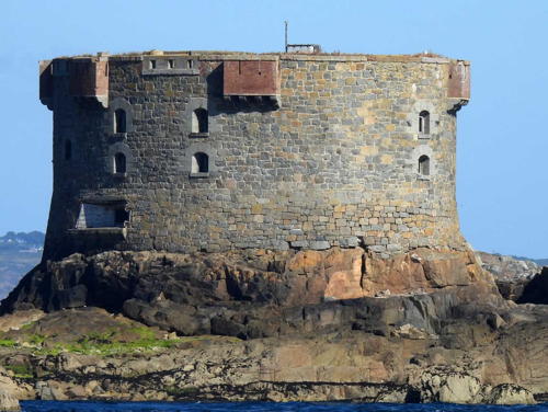
1856. Active; focal plane 19 m (56 ft); white light, 2 s on, 2 s off. Light mounted atop a circular stone fort. The light can be seen at the right end of the tower in the photo at right. A photo is at right, Trabas has Capt. Peter's photo, Alli Cleal has another closeup photo of the fort, Ian Young has another photo, and Google has a satellite view. The fort was manned for half a century and German troops used it as an observation post during World War II. Located about 5 km (3 mi) northeast of St. Peter Port. Accessible only by boat. Site open, tower closed. Operator: Guernsey Harbour Authority. ARLHS GUE-011; Admiralty A1559; NGA 8212.

Brehon Tower Light, St. Peter Port, August 2007
Flickr Creative Commons photo by Graham and Dairne

East Coast (Guernsey Harbour) Lighthouses
* St. Sampson South Pier Range Rear
1874. Active; focal plane 13 m (42 ft); continuous green light. 12 m (39 ft) 4-story square stone clock tower attached to a 2-story stone building; the light is shown through a square window poking out of the peaked roof. Trabas has Capt. Peter's photo, Wikimedia has a closeup photo and Ian Paterson's photo of the light in action, Kevin Lajoie has a drone photo, Andre Quevatre has a 2022 street view, Huelse has a postcard view of this light and the Crocq Pierhead Light, and Google has a satellite view. The tower was built as the harbor master's office but it was located specifically so that it could serve also as the rear range light. The building is occupied today by the Guernsey Lifeboat Guild, which has a gift shop to raise funds for the island's volunteer lifesaving stations. The front light is on a short pierhead mast. Located on the south side of the harbor at St. Sampson. Site open, gift shop open mornings Wednesday through Saturday, tower closed. Operator: Guernsey Harbour Authority. ARLHS GUE-008; Admiralty A1558.1; NGA 8224.
* Crocq Pierhead
Date unknown. Active; focal plane 11 m (36 ft); continuous red light. 6 m (20 ft) round cylindrical cast iron tower mounted on a circular 1-story stone equipment shelter. The light is displayed through a window at the top of the cast iron tower, which is painted bright red; the stone base is unpainted. Trabas has a 2012 photo by Klaus Potschien, Andre Quevatre has a 2022 street view, Huelse has a postcard view, and Google has a satellite view. Located at the end of a pier in the harbor of St. Sampson. Site open, tower closed. Operator: Guernsey Harbour Authority. ARLHS GUE-016; Admiralty A1554; NGA 8228.
* White Rock Pier
1908. Active; focal plane 11 m (36 ft); green light, 4 s on, 1 s off. 10 m (32 ft) round cylindrical stone tower with lantern and gallery. Tower unpainted; lantern roof painted white. Trabas has a good photo by Capt. Peter, Huelse has a historic postcard view, Philip Kersten has a street view, and Google has a satellite view. Located at the end of the pier on the north side of the entrance to St. Peter Port. Accessible by walking the pier. Site open, tower closed. Operator: Guernsey Harbour Authority. ARLHS GUE-010; Admiralty A1562; NGA 8252.
* Victoria Marina (Range Front)
Date unknown. Active; focal plane 10 m (33 ft); red light occulting once every 5 s. 7 m (23 ft) square skeletal tower with lantern. The lighthouse is painted white, except the seaward face of the lantern is painted red. Trabas has Capt. Peter's photo, Guyomard and Carceller have a photo by Laure Chappuis, Huelse has a historic postcard view, and Google has a street view and a satellite view. Located on the Victoria Pier in St. Peter Port. Site open, tower closed. Operator: Guernsey Harbour Authority. ARLHS GUE-009; Admiralty A1569; NGA 8248.
* Castle Breakwater (St. Peter Port New Harbour Range Front)
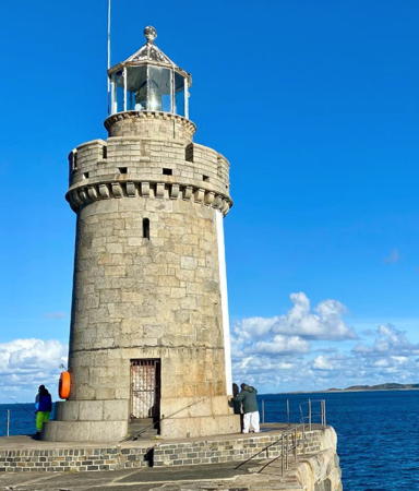
1867. Active; focal plane 14 m (46 ft); continuous light, showing white for 7.5 s, red for 2.5 s. 12 m (40 ft) round granite tower with lantern and gallery. The northeast face of the lighthouse (facing the entrance channel) is painted white, and vertical black and white stripes are painted on the head of a pier to make a more conspicuous daymark. Jeremy Oakley's photo is at right, Marianne De Guzman has a 2023 photo, Joe Dunckley has a good view of the lighthouse, Trabas has Capt. Peter's photo, Guyomard and Carceller have photos, ARLHS has a photo of the unpainted side of the lighthouse, Huelse has a historic postcard view, Philip Kersten has a street view, and Google has a satellite view. The rear light, known as the Belvedere Light, is on a short metal tower on the hill behind the town. Located at the end of the breakwater at St. Peter Port. Accessible by walking the breakwater. Site open, tower closed. Operator: Guernsey Harbour Authority. . ARLHS GUE-005; Admiralty A1560; NGA 8232.
* St. Martin's Point (Jerbourg Point)
Date unknown. Active; focal plane 15 m (49 ft); three flashes every 10 s, white or red depending on direction. 5 m (17 ft) square 1-story equipment building, painted white; the light is displayed from a short post on the roof. Trabas has Thomas Philipp's photo, Dave Sauvarin has a photo, Philip Kersten has a street view, and Google has a satellite view. Located at the southeastern tip of Guernsey. Site open, tower closed. Operator: Guernsey Harbour Authority. ARLHS GUE-007; Admiralty A1574; NGA 8256.

Castle Breakwater Light, St. Peter Port, September 2013
Flickr Creative Commons photo
by Jeremy Oakley

Sark and Alderney Lighthouses

Sark Lighthouse
Sark (locally called Sèr) is a small island (5 km by 2 km) located east of Guernsey and accessible by passenger ferry from St. Peter Port; transportation on the island is by foot, bicycle, or horse-drawn carriage. The island's population is about 600.

*
Sark (Point Robert)
1913. Active; focal plane 65 m (213 ft); white flash every 15 s. 17 m (55 ft) octagonal cylindrical tower rising from 2-story keeper's house; entire structure painted white. Fog horn (2 blasts every 30 s). Ruben Holthuijsen's photo is at right, Trabas has Darlene Chisholm's photo, Bas Quentin has a 2022 photo, Paula Funnell has a view from the sea, Huelse has a historic postcard view, Kevin Lajoie has a drone view, Clive Bond has a closeup street view, and Google has a satellite view. The rotating Fresnel lens was replaced by LED optics in 2018. Located on a cliff at the northeastern point of the island; accessible by a staircase of 165 steps down from the top of the cliff. Site open, tower closed. Operator: Trinity House. . ARLHS GUE-003; Admiralty A1544; NGA 8260.

Alderney Lighthouses
Alderney is a small island about 32 km (20 mi) northeast of Guernsey and 16 km (10 mi) west of Cap de la Hague on France's Cotentin Peninsula. The island has a population of about 1900 and is accessible by air or by ferry.

Casquets (triple towers)
1724 (height increased in 1854). Active; focal plane 37 m (120 ft); five white flashes, separated by 3.7 s, every 30 s. 23 m (75 ft) round cylindrical stone tower with lantern and gallery, painted with red and white horizontal bands; lantern painted red. A Trinity House photo is at right, MarineTraffic.com has Matthew Clarke's photo, Eddie Walshe has a 2021 view from the sea, Marinas.com has good aerial photos, Huelse has a historic postcard view, Trabas has a distant view by Kees Aalbersberg showing the isolation of the station, and Google has an indistinct satellite view of the station. The Casquets are a group of rocks about 13 km (8 mi) west of Alderney. The active tower is the northwesternmost of three towers built in 1723-24. The remaining two towers have been inactive since 1877. The round cylindrical southwestern tower, truncated and painted white, is now topped by a helipad. The square cylindrical east tower, unpainted, houses a fog horn (2 blasts every 60 s). All three towers were raised in height by 9 m (30 ft) in 1854. During World War II the Germans used the light station as an observation post and transmitter site, which attracted commando raids by British forces in 1942 and 1943. The Fresnel lens has been replaced by a Vega long-range LED beacon. Accessible only by helicopter. Site and towers closed. Operator: Trinity House. . ARLHS GUE-002; Admiralty A1532; NGA 8264.
** Alderney
1912. Active; focal plane 37 m (121 ft); four white flashes, separated by 2.3 s, every 15 s. 32 m (106 ft) round stone tower with lantern and gallery, painted white with a single broad black horizontal band, attached to 1-story stone keeper's quarters. The keeper's house is occupied by a resident warden who conducts tours of the light station. A photo is at the top of this page, a 2017 photo is available, Kevin Lajoie has a drone view, Nicholas Brown has a street view, Huelse has a historic postcard view, and Google has a satellite view. The lighthouse guards the Alderney Race (Raz Blanchard), the 16 km (10 mi) wide channel between Alderney and Cap de la Hague, the northwest corner of the Cotentin Peninsula. The Race has some of the fastest and most dangerous tidal currents in the world. Notwithstanding these hazards, in March 2011 Trinity House discontinued the station's foghorn and replaced its light with a much weaker one. This has led to protests from the harbormasters of Alderney and Guernsey. Trabas has Capt. Peter's photo showing an exterior restoration of the lighthouse in 2022. The photo at the top if this page, posted by the painting contractor KEIM, shows the results. Located on Quénard Point, the northeastern tip of Alderney. Accessible by car or by the Alderney Railway, a tourist attraction in itself. Site open; tower open to guided tours on weekends and bank holidays, or by appointment for groups of 8 or more. Operator: Trinity House. . ARLHS GUE-004; Admiralty A1536; NGA 8300.


Point Robert Light, Sark, July 2017
Wikimedia Creative Commons photo by Ruben Holthuijsen


Casquets Light, Alderney
Trinity House photo

Information available on lost lighthouses:

Notable faux lighthouses:

Adjoining pages: East: Basse-Normandie | South: Jersey

Return to the Lighthouse Directory index | Ratings key

Posted August 16, 2004. Checked and revised October 29, 2023. Lighthouses: 17. Site copyright 2023 Russ Rowlett and the University of North Carolina at Chapel Hill.