Lighthouses of France: Aquitaine

France (officially the French Republic, République française) has coasts facing south on the Mediterranean Sea, west on the open Atlantic Ocean, and north on the English Channel (La Manche in French). Long a leader in lighthouse design, France has scores of famous and historic lighthouses. And it was a French engineer and physicist, Augustin-Jean Fresnel (1788-1837), who invented the powerful and beautiful lenses used in lighthouses around the world.

For local government mainland France is divided into 94 departments (départements), which are grouped for administrative purposes into 12 regions (régions). This page lists lighthouses of the former region of Aquitaine, located on the southwestern coast of France and including the three coastal départements of Pyrénées-Atlantiques, Landes, and Gironde. In 2016 the former regions of Aquitaine, Limousin, and Poitou-Charentes were merged to form the region of Nouvelle-Aquitaine (New Aquitaine).

Aquitaine faces west on the Atlantic, or more specifically the broad bight of the Atlantic known as the Bay of Biscay in English and the Golfe de Gascogne (Gulf of Gascony) in French. The northern end of Aquitaine borders the Gironde estuary, a major shipping route leading to the port of Bordeaux. South of the Gironde the French coast is mostly low, straight, and sandy, so the lighthouses tend to be tall but widely separated. The famous resort of Biarritz is at the southern end of the region, near the Spanish border. The Atlantic coastline of Aquitaine is often called the Côte d'Argent (Silver Coast).

The French word for a lighthouse, phare, is often reserved for the larger coastal lighthouses; a smaller light or harbor light is called a feu (literally "fire," but here meaning "light") or a balise (beacon). The front light of a range (alignement) is the feu antérieur and the rear light is the feu postérieur. In French île is an island, cap is a cape, pointe is a promontory or point of land, roche is a rock, récife is a reef, baie is a bay, estuaire is an estuary or inlet, détroit is a strait, rivière is a river, and havre is a harbor.

Aids to navigation in France are maintained by the Bureau des Phares et Balises, an agency of the Direction des Affaires Maritimes (Directorate of Maritime Affairs). The Directorate has four regional offices (called Directions Interrégionale de la Mer, or DIRM) at Le Havre, Nantes, Bordeaux, and Marseille. Aquitaine lighthouses fall under the Bordeaux office, DIRM Sud-Atlantique.

ARLHS numbers are from the ARLHS World List of Lights. Admiralty numbers are from volume D of the Admiralty List of Lights & Fog Signals. U.S. NGA List numbers are from Publication 113.

General Sources
Les Sentinelles des Mers - France Atlantique
Photos and information posted by Guy Detienne.
Le Phare à travers le Monde
A large, well known site maintained by Alain Guyomard and Robert Carceller.
Phares de France
Another large and well known site, this one by Jean-Christophe Fichou.
Online List of Lights - France - Atlantic Coast
Photos by various photographers posted by Alexander Trabas. Many of the photos of Aquitaine lighthouses are by Arno Siering, Eckhard Meyer, or Capt. Peter Mosselberger ("Capt. Peter").
Phareland, le Site des Phares de France
This comprehensive site has good photos and information about the major lighthouses.
Leuchttürme in Frankreich
Photos by Andreas Köhler.
France Lighthouses
Aerial photos posted by Marinas.com.
Lighthouses in Nouvelle-Aquitaine
Photos by various photographers available from Wikimedia.
World of Lighthouses - North and West Coasts of France
Photos by various photographers available from Lightphotos.net.
Société Nationale pour le Patrimoine des Phares et Balises (SNPB)
The French national lighthouse preservation organization.
Phares d'Aquitaine
Historic postcard views posted by Michel Forand.
Französische Leuchttürme
Historic photos and postcard images posted by Klaus Huelse.
GPSNauticalCharts
Navigational chart for Aquitaine.
Navionics Charts
Navigational chart for Aquitaine.


Cap Ferret Light, Cap-Ferret, July 2018
Wikimedia Creative Commons photo by Jacquym
Lighthouses of Pyrénées-Atlantiques

The coastal region of Pyrénées-Atlantiques is the historic province of Labourd; it is part of the French Basque Country (Pays basque français, or Iparralde in Basque). The Basque word for a lighthouse is itsasargi.

Ciboure Lighthouses
Separated by the Rivière de Nivelle, the historic towns of Ciboure (Ziburu in Basque) and Saint-Jean-de-Luz (Donibane Lohizune in Basque) have the only naturally protected harbor in France south of the Gironde. Formerly a fishing port, they are now a popular resort.

* Socoa (feu antérieur) (2)
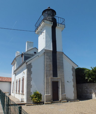
1845 (station established 1823). Active; focal plane 36 m (118 ft); quick-flashing light, white or red depending on direction. 12 m (39 ft) square cylindrical masonry tower with lantern and gallery, attached to the front of a 1- and 2-story keeper's house. Lighthouse painted white with black vertical stripes on the front (north) and west faces; lantern and gallery painted black. Fog siren located 300 m (0.3 mi) east. The town has a page for the lighthouse, Phareland has many photos, Trabas has a closeup by Siering (also seen at right), Hervé Therry has a photo, Huelse has a historic postcard view, Forand has a second postcard view, and Google has a street view and a satellite view. The first light, on a "temporary" wood tower, survived for 22 years. This is both a landfall light and the front light of an approach range guiding ships into the western entrance to the Baie de Saint-Jean-de-Luz. The rear light is on a skeletal mast. Located at the end of the Route du Phare, atop a steep bluff near the point of land at the west end of the Baie de Saint-Jean-de-Luz, about 3 km (2 mi) northwest of Ciboure. Site open, tower closed. . ARLHS FRA-470; Admiralty D1424; NGA 1700.
* Digue des Criquas
Date unknown. Active; focal plane 11 m (36 ft); green light, 2 s on, 2 s off. 6 m (20 ft) square equipment building with the light on a post on the roof. Lighthouse painted white with a green band at the top. Trabas has Capt. Peter's photo, Matthieu Tournade has a street view along the pier, and Google has a satellite view. Located at the end of the west outer breakwater of St.-Jean-de-Luz. Accessible by walking the pier. Site open, tower closed. Admiralty D1422; NGA 1696.
* Tour de Ciboure (Saint-Jean-de-Luz Feu Postérieur) (3)
1938 (station established 1870). Active; focal plane 27 m (89 ft); quick-flashing green light. 27 m (89 ft) square cylindrical masonry tower; the light is displayed from a window on the top floor. Tower painted white with a green vertical stripe on the range line. Trabas has Siering's photo, another photo is available, Guyomard and Carceller have a distant photo taken from across the harbor near the front light, and Google has a street view and a satellite view. Michel Forand has a postcard view of the previous (1872) Tour de Ciboure lighthouse; in 1938 it was incorporated into the present tower. Located at the intersection of the Quai Maurice Ravel and the Rue Ramiro Arrue in Ciboure. Site open, tower closed. . ARLHS FRA-483; Admiralty D1420; NGA 1692.
Phare de Socoa
Socoa Light, Socoa
photo copyright Arno Siering; used by permission

Saint-Jean-de-Luz Lighthouses
* Saint-Jean-de-Luz (Feu Antérieur) (3)
1938 (station established 1870). Active; focal plane 18 m (59 ft); quick-flashing green light. 14 m (46 ft) square cylindrical masonry tower; the light is displayed from a window on the top floor. Tower painted white with a red vertical stripe on the range line. Trabas has Capt. Peter's photo, Julien Vanelian has a nice 2016 photo, a 2022 photo is available, Forand has a historic postcard view, Andrzej Jaroński has a street view, and Google has a satellite view. The range guides ships across the Baie de Saint-Jean-de-Luz to the inner harbor entrance. Located on the east side of the entrance, in Saint-Jean-de-Luz. Site open, tower closed. . ARLHS FRA-482; Admiralty D1418; NGA 1688.
* Pointe Sainte-Barbe Feu Antérieur
1876. Active; focal plane 30 m (98 ft); red light, occulting four times every 12 s, intensified on the range line. 7 m (23 ft) square masonry 1-story keeper's house with a tall peaked roof; the triangular shape of the building serves a daymark. Lighthouse painted white. Trabas has Capt. Peter's photo, Engels Klaus has a 2023 closeup, Alberto Plata has a closeup street view, and Google has a satellite view. The Pointe Sainte-Barbe is the eastern entrance to the Baie de Saint-Jean-de-Luz, a picturesque elliptical harbor popular as a yacht anchorage. Located on the heights of the point, beyond the end of the Boulevard Thiers in Saint-Jean-de-Luz. Site open, tower closed. ARLHS FRA-473; Admiralty D1414; NGA 1680.
* Pointe Sainte-Barbe Feu Postérieur
1876. Active; focal plane 47 m (154 ft); red light, occulting four times every 12 s, intensified on the range line. 15 m (49 ft) square masonry 3-story keeper's house with a tall peaked roof; the triangular shape of the building serves a daymark. Lighthouse painted white. Guyomard and Carceller have photos, Trabas has Capt. Peter's photo, Huelse has a historic postcard view, and Google has a closeup street view and an excellent satellite view. This is the second range for ships entering Saint-Jean-de-Luz. Located on the Rue de Sainte-Barbe, on the heights of the point, 340 m (0.21 mi) east southeast of the front light. Site open, tower closed. ARLHS FRA-814; Admiralty D1416; NGA 1684.
* Guéthary Feu Postérieur
Date unknown. Active; focal plane 33 m (108 ft); quick-flashing red light. 7 m (23 ft) semicircular stone tower attached to the front of a 1-story stone equipment shelter. Trabas has Capt. Peter's closeup photo, Wikimedia has a photo, Guyomard and Carceller have a distant view, Forand has a historic postcard view, and Google has a satellite view. This tower is an atalaye, a watchtower used to spot whales. It's not known when a navigational light was added. The range guides ships into an open roads; there is no protected harbor. The front light is on a 7 m (23 ft) post. Located atop a bluff at Guéthary, about 8 km (5 mi) southwest of Biarritz. Site open, tower closed. ARLHS FRA-810; Admiralty D1413.1; NGA 1668.

Biarritz Lighthouse
Originally a whaling town, Biarritz (Miarritze in Basque) has been a very fashionable seaside resort for more than two centuries. The town has a permanent population of about 26,000.

****
Pointe Saint-Martin (Biarritz)
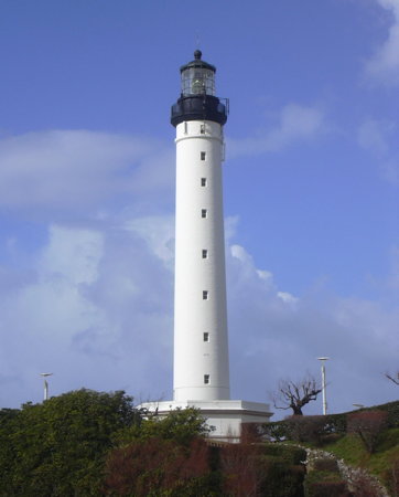
1834. Active; focal plane 73 m (240 ft); two white flashes every 10 s. 47 m (154 ft) round masonry tower with lantern and gallery, rising from the center of a 2-story octagonal keeper's house; clamshell Fresnel lens (1904). Tower and keeper's house painted white, lantern and gallery black. Peter Potrowl's photo is at right, Matthieu Luna has a closeup photo, Phareland has good photos, Trabas has a photo, Ariel Danilo Contreras has a 2023 photo, Wikimedia has many photos, French Wikipedia has an article on the lighthouse, Huelse has a historic postcard view, and Google has a street view and a great satellite view. This lighthouse commands a magnificent view of the Atlantic on one side and the Pyrénées mountains on the other. The keeper's house is staffed by a resident keeper. In 2020 a €300,000 project restored the lantern and repaired some leaks in the tower. Located at the end of the Avenue de l'Impératrice on the promontory of Cap Hainsart; this is on the north side of the resort city of Biarritz at the northern end of the popular Plage Miramar beach. Site open, parking provided; tower open daily June through September and on weekends and school holidays in the spring and fall. . ARLHS FRA-072; Admiralty D1410; NGA 1660.

Pointe St.-Martin Light, Biarritz, February 2007
Wikimedia Creative Commons photo
by Peter Potrowl

Bayonne Lighthouses
The port of Bayonne (Baiona in Basque) is on the Rivière de l'Adour; the river is the boundary between the departments of Landes and Pyrénées-Atlantiques. The city has a population of about 52,000.
* L'Adour Jetée Sud
1964 (?). Active; focal plane 9 m (30 ft); green light, 2 s on, 2 s off. 8 m (26 ft) square concrete block tower with gallery but no lantern, painted white with a green band at the top. Trabas has Capt. Peter's closeup photo, Julien Vanelian has another closeup, Köhler has a 2023 photo, and Google has a satellite view and a distant street view. Located at the end of the jetty on the south side of the entrance to the Rivière de l'Adour. Accessible by walking the pier. Site open in good weather, tower closed. ARLHS FRA-203; Admiralty D1387.4; NGA 1612.
* L'Adour (Bayonne) Sémaphore (2)
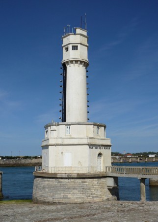
1868 (station established 1860). Inactive as a lighthouse. 14 m (46 ft) round masonry tower, with cylindrical tower supporting a hexagonal watch room centered on a 2-story hexagonal base. Building painted white with a black vertical stripe on the seaward side. A photo is at right, Stéphane Mousset has a 2018 photo, and Google has a street view and a satellite view. The tower showed a continuous light, white when it was safe to enter and red otherwise; it was still in use in the early 1900s. The historic building is apparently still in use as a signal tower and control room for the port of Bayonne. Located a few feet off the south side of the Rivière de l'Adour just inside the entrance. Site open, parking available nearby, tower closed. ARLHS FRA-813.
#L'Adour Feu Antérieur (1)
Date unknown (1950s?). Removed. 4 m (13 ft) cylindrical tower with a conical roof, mounted on rails atop steel pilings. The light was displayed through a square window. Tower painted white with a green vertical stripe on the range line. Guyomard and Carceller have a photo identified as "Feu de l'Adour" and Google has a satellite view. This unusual light was designed so that it could be moved laterally to adjust the exact bearing of the range, which guides ships through the entrance to the estuary of l'Adour and the harbor of Boucau. However, Trabas has Capt. Peter's photo showing that the light (focal plane 6 m (20 ft); continuous green light, intensified on the range line) has been replaced by an ordinary post light with a daymark panel colored white with a green vertical stripe. Located on the south bank of the estuary; visible from the Avenue de l'Adour, which runs close to the bank. Site status unknown. Active light: Admiralty D1388; NGA 1620.
* L'Adour Feu Postérieur
Date unknown (1950s?). Active; focal plane 10 m (33 ft); continuous green light, intensified on the range line. 9 m (30 ft) light mounted on the outside of the square cupola of the port captain's office. Lighthouse painted white with an orange tile roof. Trabas has Capt. Peter's photo and Google has a street view and a satellite view of the building. Located on the south bank of L'Adour, 150 m (165 yd) east southeast of the front light; visible from the Avenue de l'Adour, which runs close to the bank. Site appears to be open, parking available nearby, tower closed. Admiralty D1388.1; NGA 1624.
Sémaphore de l'Adour
Sémaphore de l'Adour, Bayonne, September 2009
ex-Panoramio Creative Commons photo by nicolapin

Lighthouses of Landes

Landes is a large département but its coastline is mostly straight sandy beaches with no significant harbors. The name comes from the Gascon word lanas, related to the Spanish llanos, meaning a moorland or heathland.

Tarnos Lighthouse
Tarnos is a town of about 13,000 residents on the north bank of the Rivière de l'Adour opposite Bayonne.

#L'Adour North Training Wall
Date unknown. Removed but still listed by the Admiralty. This was an approx. 7.5 m (25 ft) round unpainted stone tower. No lens is seen in Trabas's photo by Meyer. Google has a satellite view. When Andreas Köhler visited in 2023 he found the lighthouse missing. Located on the north bank of the Adour near the base of the north jetty. Site open, and nothing prevents climbing the tower. Admiralty D1390.6.
* L'Adour Jetée Nord
1964 (?). Active; focal plane 12 m (39 ft); red light, 2 s on, 2 s off. 10 m (33 ft) triangular skeletal tower mounted on a square concrete block tower. Tower painted white with a red horizontal band at the top of the concrete block tower. Trabas has Capt. Peter's photo, Köhler has a 2023 photo, Jean-Pierre Joignant has a street view, and Google has a street view and a satellite view. The skeletal tower is a relatively recent extension of this light. Located at the end of the jetty on the north side of the entrance to the Rivière de l'Adour. Accessible by walking the pier. Site open, parking available, tower closed. Site open, tower closed. ARLHS FRA-202; Admiralty D1387.3; NGA 1608.
* Digue Jean Lesbordes (L'Adour North Breakwater)
Date unknown. Active; focal plane 11 m (36 ft); quick-flashing red light. 10 m (33 ft) square concrete block tower. Tower painted white with a red horizontal band at the top. Trabas has Capt. Peter's photo, Christian Robineau has a 2023 sunset photo, and Google has a satellite view. Located at the end of the curving breakwater on the north side of the entrance to the Rivière de l'Adour. Accessible by walking the pier. Site open, parking available, tower closed. Site open, tower closed. Admiralty D1387; NGA 1596.

Capbreton Lighthouses
Capbreton is a beach resort town about 40 km (25 mi) north of Biarritz. The artificial harbor at Capbreton is entered through a narrow cut called the Passe du Boucart.

*
Capbreton Estacade Sud (2)
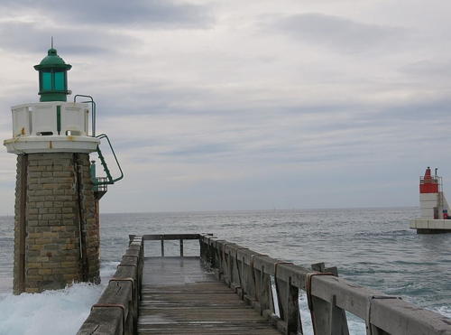
1948 (station established 1873). Inactive. 8 m (26 ft) round solid stone tower with lantern and gallery. Tower is unpainted stone; lantern painted green, gallery white. A photo is at right, Antoine Davi has a 2021 photo, Guyomard and Carceller have several photos, Wikimedia has Remi Jouan's photo showing all the Capbreton lights, Huelse has a historic postcard view, Forand has a postcard view showing the tower without its lantern, and Google has a street view and a satellite view. The active light (focal plane 9 m (30 ft); two green flashes every 6 s) has been moved to a post about 40 m (130 ft) to the west. Forand also has a postcard view of the first light. Located adjacent to the wooden pier (estacade) on the south side of the entrance to Capbreton. Site open, tower closed. ARLHS-808; Admiralty D1386; NGA 1588.
 

Estacade Sud (left) and Jetée Nord Lights, Capbreton, October 2016
Wikimedia public domain photo by Tangopaso
 
* Capbreton Jetée Nord
1975. Active; focal plane 13 m (43 ft); two red flashes every 6 s. 6 m (20 ft) round cylindrical concrete tower with a small lantern. Tower is unpainted white concrete; lantern painted red. A photo is above right, Trabas has Capt. Peter's photo, Hervé Therry has a 2020 closeup, Guyomard and Carceller have several photos, and Google has a street view and a satellite view. The lighthouse was restored and repainted in 2009. Located at the end of the breakwater mole of Capbreton. Site open, tower closed. ARLHS-809; Admiralty D1384; NGA 1584.

Vielle-Saint-Girons Daybeacon
* [Huchet (2)]
1890 (station established 1865). Inactive daybeacon. 8 m (26 ft) square skeletal tower carrying two large triangular daymarks, point up. Originally the upper triangle was painted black and the lower one white, but little paint remains. Olivier Vanderbecq has a photo but the tower is hard to see in Google's satellite view. This is the only survivor of several daybeacons placed along the Landes coast to help sailors locate themselves in the long gaps between major lighthouses. Located on dunes behind the beach near Vielle-Saint-Girons about 27 km (16 mi) north of Capbreton. Site open, tower closed.

St.-Julien-en-Born Lighthouse
The rural commune of Saint-Julien-en-Born is best known for the wide beach of Contis, a popular beach resort.

***
Contis
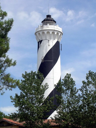
1863. Active; focal plane 50 m (164 ft); four white flashes, separated by 4.1 s, every 25 s. 42 m (138 ft) round masonry tower with lantern and gallery. Tower painted in a black and white spiral pattern; lantern painted black, gallery white. 1-story keeper's house and other light station buildings. A photo is at right, Loran Tatooine has a photo, Trabas has Capt. Peter's photo, Phareland has photos, Wikimedia has many photos, French Wikipedia has an article on the lighthouse, Marinas.com has aerial photos, and Google has a satellite view and a street view from the gallery. The spiral daymark, unusual for French lighthouses, was suggested in 1937 by the painter Bellocq; Huelse has a postcard view made before the spiral was applied. The lighthouse marks the center of an otherwise dark section of the coast between the Bassin d'Arcachon and Biarritz. The lighthouse was damaged and the original lantern destroyed during World War II. The keeper's house is occupied by a resident caretaker, who has developed a small museum and offers guided tours to visitors. Located at Contis-Plage, at or near the end of the D41 highway. Site open, limited parking available, tower open daily except Mondays in July and August, also Friday through Sunday in April through June and in September. . ARLHS FRA-088; Admiralty D1382; NGA 1580.
Phare de Contis
Contis Light, St.-Julien-en-Born, July 2009
Wikimedia Creative Commons photo by Jibi44

Lighthouses of Gironde

Cap Ferret Lighthouse
**** Cap Ferret (Bassin d'Arcachon) (2)
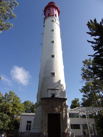
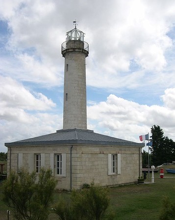
1947 (station established 1840). Active; focal plane 53 m (174 ft); red flash every 5 s; also at 46 m (151 ft) a white light occulting three times every 12 s. 52 m (171 ft) round cylindrical concrete tower with lantern and gallery, rising from the center of a 1-story circular keeper's house; the top section of the tower is 12-sided. Lantern, gallery, and the 12-sided section painted red, the rest of the tower white. A photo appears at the top of this page, Detienne has a good page for the lighthouse, Trabas has a photo by Thomas Philipp, Phareland has many photos, Stephanie Zahra has a closeup 2022 photo, and Google has a street view and a satellite view. This famous and handsome lighthouse should not be confused with the equally famous lighthouse of Cap Ferrat near Nice on the Mediterranean coast (see the Alpes-Maritimes page). The lighthouse is a copy in concrete of the original masonry lighthouse, which was dynamited by German troops on 22 August 1944. Huelse has a postcard view of the historic tower. However, the newer tower is equipped with an elevator in addition to the traditional spiral stairway. The station includes a museum. The lighthouse stands at the end of a peninsula sheltering the Bassin d'Arcachon, the only large harbor between the Gironde and the Spanish border. Located at the end of the D106 highway in Cap-Ferret. Site open, tower open for climbing daily April through September and Wednesday through Sunday the rest of the year. . ARLHS FRA-226; Admiralty D1378; NGA 1560.

Hourtin Lighthouses
Hourtin (Tour Sud)
1863. Inactive since 1894. 23 m (75 ft) square brick tower with gallery, topped by two parabolic antennas and other communications gear. Tower is unpainted red brick with stone trim.Dominique Barrere has a photo and Google has a satellite view. Twin towers were built at this station, a configuration unusual for France, but the south tower was deactivated in 1894. The Southern Methodist University Library has an 1883 photo of the two lighthouses. The purpose of the light was to mark the center of an otherwise dark section of unbroken coast between the mouth of the Gironde and the Bassin d'Arcachon. The south lighthouse stood abandoned from 1894 until 1964, when the defense ministry reactivated the tower as a satellite tracking station. The station is surrounded by the Forêt d'Hourtin, a national maritime forest reserve. Located 200 m (220 yd) south of the north tower. Site and tower closed, but Ruiz's photo indicates the tower can be viewed from the north tower. Site manager: Ministère des Armées. ARLHS FRA-811.
Phare Nord de Hourtin
Hourtin Light (Tour Nord), Hourtin, November 2006
Wikimedia Creative Commons photo by Georges Schultz
* Hourtin (Tour Nord)
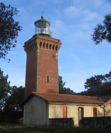
1863. Active; focal plane 55 m (180 ft); white flash every 5 s. 27 m (89 ft) square brick tower with lantern and gallery. Tower is unpainted red brick with stone trim; lantern painted black. 2-story brick keeper's house and other light station buildings. Georges Schultz's photo is above right, Trabas has Stephen Hix's photo, Pascal Ryker has a 2019 photo, Huelse has a historic postcard view, and Google has a satellite view. Located on a dune behind the ocean beach about 6 km (4 mi) south of Hourtin-Plage. Site open, tower closed. . ARLHS FRA-105; Admiralty D1372; NGA 1556.

The Gironde is a broad estuary, the largest estuary of western Europe, formed by the Rivers Dordogne and Garonne at their meeting in Bordeaux, a major port and the capital of Nouvelle-Aquitaine. The estuary is about 80 km (50 mi) long and 3–11 km (2–7 miles) wide. Subject to strong tidal currents it is not easy to navigate. Only the south side of the estuary is in Aquitaine; lighthouses on the north side are described on the Charente-Maritime page.

St.-Vivien-de-Médoc (Gironde Entrance) Lighthouses
**** Cordouan (2)
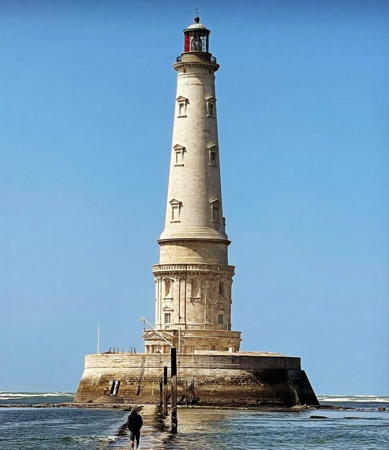
1611. Active; focal plane 60 m (197 ft); white, red, or green light, depending on direction, occulting three times every 12 s. 68 m (223 ft) round stone tower with lantern and three galleries, incorporating keeper's quarters; 1st order Fresnel lens. The tower is unpainted light gray stone; lantern and gallery are a darker gray. The lighthouse includes a cylindrical 3-story base with two galleries, built in 1611, surmounted by a tall conical tower completed in 1788. A 2023 photo is at right, Javi Cabrera has a 2021 photo, Guyomard and Carceller have many photos, Jaufré Rudel has a good photo, a 2009 photo is available, Trabas has Capt. Peter's photo, French Wikipedia has a good article with many photos, Detienne has a page for the lighthouse, Huelse has a historic postcard view, Drio Do has a street view, and Google has a satellite view. This is the oldest and perhaps greatest of French lighthouses and one of the most famous lighthouses in the world. In the west of France it is called le roi des phares et le phare des rois (the king of lighthouses and the lighthouse of kings). It marks the entrance to the Gironde, standing on a sandbar in the mouth of the estuary. According to legend, Charlemagne commanded that a light be shone here in the early ninth century. It's more certain that the English Prince Edward (the Black Prince), ruling southwestern France as Duc d'Aquitaine, built a 16 m (52 ft) stone tower in 1360 and engaged monks to keep a fire burning. The lower portion of the present lighthouse remains from the work of Louis de Foix, who spent 18 years building the lighthouse from 1584 to his death in 1604; others continued his work. The original lighthouse was an elaborate structure that included a chapel and a royal apartment (although no king ever visited). Huelse has a drawing of this famous building. In 1645 the wood-fired lantern was blown off by a storm and replaced by a new lantern designed to burn whale oil. This was replaced in 1727 by a third lantern designed for charcoal. Parabolic reflectors of the Argand design were installed in 1782, but shortly thereafter the original superstructure was entirely removed and replaced with the soaring conical tower that survives to the present. In 1823 Augustin-Jean Fresnel brought the first of his lenses to the tower, and here he perfected the lens designs that were soon in use around the world. The present lens was installed in 1854 during a thorough restoration of the tower ordered by Napoleon III. The lighthouse was not electrified until 1948. In 1981 the Bureau des Phares et Balises announced plans to replace the historic tower with an offshore lightfloat. This led to a great uproar and the formation of a preservation group, the Association pour la Sauvegarde du Phare de Cordouan. Now called the Association des phares de Cordouan et de Grave, the Association maintains a museum devoted to the history of the lighthouse at the Pointe de Grave lighthouse. Instead of abandoning the lighthouse steps were taken to restore it. In 1987 a modern halogen lamp was installed; since the lamp's light could be flashed, the rotating mechanism was then retired. In 2005 a restoration was completed, but restoration work resumed in 2013 and continued off and on for nine years. The tower reopned to visitors in 2022. Cordouan is the last staffed lighthouse in France; keepers called Guardiens Cordouan occupy the building in the summer season, working on needed maintenance and guiding visitors. Located 7 km (4 mi) west northwest of the Pointe de Grave, the southern entrance to the Gironde. Accessible only by boat, but tours are available from Royan and from Verdun-sur-Mer. Site open, tower open occasionally to guided tours. Site manager: Association des phares de Cordouan et de Grave. . ARLHS FRA-007; Admiralty D1300; NGA 1480.

Le Phare de Cordouan, Le Verdun-sur-Mer, July 2023
Instagram photo by gregbdx33
* Saint-Nicolas (feu antérieur)
1873. Active; focal plane 22 m (72 ft); quick-flashing green light, intensified on the range line. 13 m (43 ft) square 3-story tower with a domed roof; the light is displayed through a square opening on the third floor. Solar panels atop the dome provide power. Lighthouse painted white. Trabas has a closeup, Hajo Houschd has a 2022 photo, and Google has street view and a satellite view. This light and the Pointe de Grave light provide an approach range for ships approaching the Gironde entrance. Located just behind the ocean beach, 1550 m (1 mi) southwest of the Pointe de Grave lighthouse in Verdon-sur-Mer. Site open, tower closed. ARLHS FRA-625; Admiralty D1310; NGA 1500.
**** Pointe de Grave (feu postérieur) (6)
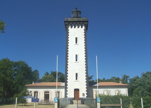
1860 (station established 1823). Active; focal plane 26 m (85 ft); white, red, or green light, depending on direction, occulting once every 4 s. 25 m (82 ft) square cylindrical masonry tower with lantern and gallery, rising from a 1-story keeper's house. Tower painted white with dark gray trim; lantern painted black. Florian Pépellin's photo is at right, Trabas has an excellent photo by Capt. Peter, Tiphaine Lelong has a 2023 photo, another closeup photo is available, Huelse has a historic postcard view, and Google has a street view and a satellite view. Fichou recounts the early history of this station, when a series of temporary and "permanent" lights fell victim to the sea on the highly mobile point. Finally the lighthouse was set back from the sea, where it has survived nearly 150 years. In recent years management of the lighthouse has been assumed by the Association des phares de Cordouan et de Grave, which operates a museum in the keeper's house with exhibits on Cordouan, this light, and other lights of the Médoc region. Located in Verdon-sur-Mer, near the terminal for ferries crossing the Gironde from Royan. Site open, museum and tower open daily in July and August and Friday through Monday in May, June, September and October. Site manager: Association des phares de Cordouan et de Grave. . ARLHS FRA-155; Admiralty D1310.1; NGA 1504.
Phare de Grave
Pointe de Grave Light, Verdon-sur-Mer, July 2008
Wikimedia Commons photo by Florian Pépellin

Canton de Pauillac (Gironde Estuary) Lighthouses
**** Pointe de Richard (1)
1845. Inactive since 1870. 16 m (52 ft) round cylindrical stone tower with lantern and gallery, rising from the center of a 1-story keeper's house. Frédéric Bourset's photo is at right, Guyomard and Carceller have good photos, and Google has a street view and a satellite view. This lighthouse marked a prominent point on the Gironde, a point marked for many years by a giant poplar tree known as L'Arbre de Richard. After the tree was overthrown by a storm in 1830, a buoy was placed in the river. When that proved inadequate the lighthouse was built. In 1870 the light was moved to a 30 m (98 ft) cast iron tripod tower which formed the rear light of a range, the front light being on the lightship Talais. Fichou has the history of that tower, Huelse has a historic postcard view showing both lighthouses, and Forand has a different postcard view. The keeper's house remained in service until the station was deactivated in 1953; the tripod tower was demolished in 1956. Detienne has a page for the surviving lighthouse and a second page for the tripod tower. Sold into private ownership, the station stood abandoned until a group of teenagers launched the first restoration effort in 1982. In 1988 the station was purchased by the township of Jau-Dignac et Loirac. A preservation group, L'Association Communale du Phare de Richard, was organized in 1993 and the keeper's house was renovated as a fishery and lighthouse museum. A model of the tripod lighthouse stands in front of the museum. Located on the point, about 2 km (1.2 mi) north of Port de Richard on the south side of the Gironde estuary. Site open, museum and tower open daily in July and August and Wednesday through Sunday in March through June and in September and October; group tours are available year-round. Owner: Commune du Jau-Dignac et Loirac. Site manager: L'Association Communale du Phare de Richard . ARLHS FRA-448.
Trompeloup (feu antérieur)
1901. Inactive since 1992 (?); charted as a landmark. 13 m (43 ft) round stone tower with gallery, incorporating keeper's quarters. Lantern removed. Upper half of tower painted red, lower half white; the colors have faded considerably since deactivation. Hervé Therry has a photo, Forand has a historic postcard view, and Google has a satellite view. This was the front light of an upstream (southbound) range, the Île de Patiras lighthouse being the rear light. The range was deactivated after a change in the channel made it useless. Located in the middle of the Gironde about 3 km (2mi) southeast of Saint-Estèphe and 2650 m (1.65 mi) north of the Île de Patiras lighthouse. Accessible only by boat; there should be good views from the riverside D2 highway south of Saint-Estèphe. Site open, tower closed. ARLHS FRA-745.

Pointe de Richard Light, Jau-Dignac et Loirac, August 2006
Flickr Creative Commons photo
by Frédéric Bourset
** Île de Patiras (feu postérieur) (2)
1879 (station established 1860). Inactive since 1992; charted as a landmark. 22 m (72 ft) square masonry tower with gallery, topped by a 9 m (30 ft) tall cylindrical lantern structure added in 1971 to bring the total height to 31 m (102 ft). Tower painted white; lantern painted red. A page for the lighthouse has several photos, Nelly Faucheron has a 2018 photo, Bothamy Chantal has a 2016 photo, Guillaume Ardoin has a street view from the gallery, and Google has a satellite view. The original light here was on a 13 m (43 ft) wood skeletal tower. This was the rear light of an upstream (southbound) range, the Trompeloup lighthouse being the front light. The range was deactivated after a change in the channel made it useless. The Île de Patiras is an island in the middle of the Gironde opposite Pauillac. About 3 km (2 mi) long and 1.5 km (1 mi) wide, the island has been at various times a pirate base, leper colony, and place of exile for Jews from Bordeaux. Today it is the site of a large vineyard producing Bordeaux wine. In 1999 a great storm inundated the island and damaged the lighthouse. This led to negotiations between Philippe Lacourt, the island's owner, and the Conservatoire du Littoral. The lighthouse was restored in 2008 with the help of €650,000 grant, and in October 2008 it was opened to the public for the first time, with guided tours organized by the Gens d'Estuaire. Accommodations on the island are also available. The lighthouse is on the west side of the island near the northern tip. The island is accessible only by boat; transportation from Pauillac can be arranged. Site open, tower open but no schedule is available. Site manager:: Gens d'Estuaire (Refuge de Patiras). . ARLHS FRA-812.

Information available on lost lighthouses:

Notable faux lighthouses:

Adjoining pages: North: Charente Coast | South: Spain: Basque Country

Return to the Lighthouse Directory index | Ratings key

Posted October 30, 2005. Checked and revised August 12, 2023. Lighthouses: 27. Site copyright 2023 Russ Rowlett and the University of North Carolina at Chapel Hill.