Lighthouses of France: Alpes-Maritimes (French Riviera)

France (officially the French Republic, République française) has coasts facing south on the Mediterranean Sea, west on the open Atlantic Ocean, and north on the English Channel (La Manche in French). Long a leader in lighthouse design, France has scores of famous and historic lighthouses. And it was a French engineer and physicist, Augustin-Jean Fresnel (1788-1837), who invented the powerful and beautiful lenses used in lighthouses around the world.

For local government mainland France is divided into 94 departments (départements), which are grouped for administrative purposes into 12 regions (régions). This page describes lighthouses of the Department of Alpes-Maritimes, part of the Côte d'Azur, France's southeastern coast, often called the French Riviera in English. Alpes-Maritimes was part of the historic province of Provence and is now included in the region called Provence-Alpes-Côte d'Azur (Région Sud for short). Alpes-Maritimes includes many of the most famous resorts of the Riviera, including Nice, Antibes, and Cannes.

The eastern half of Alpes-Maritimes was formerly included in the County of Nice, a part of the Kingdom of Sardinia until 1860. However, no lighthouses survive from the period of Sardinian rule. Embedded in the County of Nice, near the Italian border, is the independent Principality of Monaco. There is a separate page for lighthouses of Monaco.

The French word for a lighthouse, phare, is often reserved for the larger coastal lighthouses; a smaller light or harbor light is called a feu (literally "fire," but here meaning "light") or a balise (beacon). The front light of a range (alignement) is the feu antérieur and the rear light is the feu postérieur. In French île is an island, cap is a cape, pointe is a promontory or point of land, roche is a rock, récife is a reef, baie is a bay, estuaire is an estuary or inlet, détroit is a strait, rivière is a river, and havre is a harbor.

Aids to navigation in France are maintained by the Bureau des Phares et Balises, an agency of the Direction des Affaires Maritimes (Directorate of Maritime Affairs). The Directorate has four regional offices (called Directions Interrégionale de la Mer, or DIRM) at Le Havre, Nantes, Bordeaux, and Marseille. Mediterranean lighthouses fall under the Marseille office, DIRM Méditerranée.

ARLHS numbers are from the ARLHS World List of Lights. FR numbers, where available, are the French light list numbers. Admiralty numbers are from volume E of the Admiralty List of Lights & Fog Signals. U.S. NGA List numbers are from Publication 113.


Cap Ferrat Light, Villefranche-sur-Mer, March 2021
Google Maps photo by Adib Rachid

General Sources
Les Sentinelles des Mers - Méditerranée
Photos and information posted by Guy Detienne.
DIRM Méditerranée - Phares de Méditérranée (Continental Est)
An interactive map leads to information and photos for the major lighthouses.
Phares d'Europe
A large, well known site maintained by Alain Guyomard and Robert Carceller.
Phareland, le Site des Phares de France
This comprehensive site has good photos and information about the major lighthouses.
Online List of Lights - Mediterranean France
Photos by various photographers posted by Alexander Trabas. For this area many of the photos are by Capt. Peter Mosselberger ("Capt. Peter"), Arno Siering, or Eckhard Meyer.
Lighthouses in Alpes-Maritimes
Photos by various photographers available from Wikimedia.
World of Lighthouses - South Coast of France
Photos by various photographers available from Lightphotos.net.
France Lighthouses
Aerial photos posted by Marinas.com.
Société Nationale pour le Patrimoine des Phares et Balises (S.N.P.B.)
The French national lighthouse preservation organization.
Französische Leuchttürme
Historic photos and postcard images posted by Klaus Huelse.
GPSNauticalCharts
Navigation chart information for southern France.
Navionics Charts
Navigation chart for southern France.

L'Îlette (Cap d'Antibes) Light, Antibes, June 2020
Instagram photo by Gregory Bonin de Pissarro

Coastal Lighthouses

Menton Lighthouses
Menton-Garavan
1966. Active; focal plane 11 m (36 ft); two red flashes every 6 s. 10 m (33 ft) round stone tower. The seaward side of the tower is painted white with a red horizontal band at the top; the landward side is unpainted. Trabas has a fine closeup photo by Capt. Peter, Chris Continanza has a photo, and Google has a sea view, a street view and a satellite view. The harbor of Garavan is only 700 m (0.4 mi) west of the Italian border. Located at the end of the Garavan breakwater. Site and tower closed but there is an excellent view from the shore. ARLHS FRA-356; Admiralty E0849; NGA 7272.
* Menton
1890. Active; focal plane 16 m (52 ft); four very quick red flashes every 3 s. Approx. 10 m (33 ft) round cylindrical cast iron tourelle with lantern and gallery, mounted on a large stone pier. Tower painted white, lantern and gallery red. Andre Japink's photo is at right, Trabas has an excellent photo by Capt. Peter, a fine closeup is available, Icare Phenix has a 2022 photo, and Google has a sea view, a street view and a satellite view. Small cast iron towers of this type, called tourelles, were manufactured and installed in large numbers during the late 1800s and very early 1900s. Few survive on the Mediterranean coast where German troops destroyed nearly all harbor lights in 1944 to prevent their use by Allied forces. As a result this little lighthouse is a rare and valuable monument. Located on the end of the breakwater mole (the Quai Napoléon III) on the south side of the harbor of Menton, about 2 km (1.2 mi) west of the Italian border. Site open, tower closed. ARLHS FRA-357; Admiralty E0848; NGA 7268.

There is a separate page for the lighthouses of the Principality of Monaco, located between Menton and Cap Ferrat.

Cap Ferrat and Villefranche Lighthouses
Beaulieu-sur-Mer Northeast Head
Date unknown. Active; focal plane 7 m (23 ft); quick-flashing red light. 5 m (16 ft) round tower painted white with a red band at the top. Trabas has Capt. Peter's closeup photo and Google has a sea view and a satellite view. Located at the northeast end of the detached breakwater at Beaulieu-sur-Mer, a resort at the eastern base of the Cap Ferrat peninsula. Accessible only by boat but easy to see from shore. Site open, tower closed. Admiralty E0836; NGA 7224.
Beaulieu-sur-Mer Southwest Head
Date unknown. Active; focal plane 7 m (23 ft); three green flashes every 12 s. 5 m (16 ft) round tower painted white with a green band at the top. Trabas has Capt. Peter's closeup photo and Google has a sea view and a satellite view. Located at the southwest end of the detached breakwater at Beaulieu-sur-Mer. Accessible only by boat but easy to see from shore. Site open, tower closed. ARLHS FRA-189; Admiralty E0836.2; NGA 7228.

Menton Light, Menton, March 2024
Google Maps photo by Andre Japink
* Saint-Jean-Cap-Ferrat (3)
Date unknown (station established 1867). Active; focal plane 9 m (30 ft); four white flashes every 12 s. 9 m (30 ft) round concrete or masonry tower. Lighthouse painted white with a red lantern structure supporting the light. Trabas has Capt. Peter's closeup photo, another photo is available, and Google has a sea view and a satellite view. Located at the end of the breakwater of Saint-Jean-Cap-Ferrat, on the east side of the peninsula of the cape about 2.5 km (1.5 mi) north of the Cap Ferrat lighthouse. Accessible by walking the breakwater. Site open, tower closed. ARLHS FRA-838; Admiralty E0833; NGA 7220.
* Cap Ferrat (2)
1952 (station established 1838). Active; focal plane 69 m (226 ft); white flash every 3 s. 32 m (105 ft) octagonal stone tower with lantern and gallery, attached to a 2-story masonry keeper's house. The tower is unpainted white stone; the lantern is green with a white roof. Adib Rachid's 2021 photo is at the top of this page, Eric Deniaud has a 2022 photo, Trabas has a closeup photo by Peter Doll, Eric Farber has a good photo, Wikimedia has several photos, and Google has a sea view, a satellite view and a walkway view from below the lighthouse. This is one of the oldest light stations of the Côte d'Azur, along with Cap Camarat and Antibes. It was established by the Kingdom of Sardinia, which controlled Nice until 1860. Huelse has a historic postcard view of the original lighthouse, which was blown up by German troops in 1944. Cap Ferrat is a very prominent cape projecting into the Mediterranean between Nice and Monaco. Located above the point of the cape, on the Avenue du Phare in Villefranche-sur-Mer. Site open, tower closed. . ARLHS FRA-099; FR-1508; Admiralty E0828; NGA 7216.
* Villefranche-sur-Mer (3)
Date unknown (station established 1867). Active; focal plane 8 m (26 ft); quick-flashing light, white or red depending on direction. 9 m (30 ft) round tower, with a red cylindrical lantern structure centered on the roof of a square 1-story white masonry equipment building. Adrian Cid has a 2021 photo, Trabas has Capt. Peter's photo, Guyomard and Carceller have a photo, and Google has a street view, a sea view and a satellite view. Located at the end of the main breakwater of Villefranche-sur-Mer. Accessible by walking the pier. Site open, tower closed. ARLHS FRA-534; Admiralty E0830; NGA 7208.

Nice and Saint-Laurent-du-Var Lighthouses
* Nice (2)
1880 (station established 1855). Inactive since 1909. Approx. 11 m (36 ft) white round masonry tower; lantern removed. Google has a street view, a sea view and a satellite view. The harbor of Nice is protected by a breakwater that extends to the east. New lighthouses were built on the breakwater each time it was extended: in 1880, 1909, and 1928. The 1909 lighthouse was cast iron, so the "ancien feu de Nice" in Guyomard and Carceller's photo must be the 1880 tower. Located at the end of the Traverse du Commerce, the cruise ship quay of Nice. Site open, tower closed.
* Nice (6)
Date unknown (probably around 1950). Active; focal plane 21 m (69 ft); red flash every 5 s. 22 m (72 ft) square masonry tower with lantern and gallery, mounted on a large square stone base. Lighthouse is white, lantern red with a white roof. A 2022 photo is at right, Trabas has a closeup photo by Capt. Peter, Guyomard and Carceller have additional closeup photos, Wikimedia has several photos, Faradj Saadana has a street view from the pier, and Google has a sea view and a satellite view. The 1928 lighthouse, the fourth on the Nice breakwater, was heavily damaged during World War II; it was replaced by a wooden tower in 1945 and then by this lighthouse. Located at the end of the Nice breakwater; accessible by walking the pier. Site open, tower closed. . ARLHS FRA-370; FR-1500; Admiralty E0822; NGA 7184.
* Saint-Laurent-du-Var
Date unknown. Active; focal plane 10 m (33 ft); three green flashes every 12 s. 8 m (26 ft) round concrete tower, painted white with a green band at the top. Trabas has Capt. Peter's closeup photo and Google has a sea view, a street view and a satellite view. Located at the end of the east breakwater at the Marina Saint-Laurent-du-Var, just west of the Nice airport. This breakwater does not appear to be walkable. Site open, tower closed. ARLHS FRA-618; Admiralty E0821; NGA 7168.

Nice Light, Nice, May 2022
Google Maps photo by Mauggel '

Antibes Lighthouses
Marina Baie des Anges Jetée Est
Date unknown. Active; focal plane 13 m (43 ft); two green flashes every 6 s. 10 m (33 ft) round tower, painted white with a green band at the top. Trabas has Capt. Peter's closeup photo and Google has a street view, a sea view, and a satellite view. Located at the end of the east breakwater at the Marina Baie des Anges, north of Antibes. This breakwater does not appear to be walkable. Site open, tower closed. ARLHS FRA-543; Admiralty E0818.7; NGA 7164.
Marina Baie des Anges Jetée Sud
Date unknown. Active; focal plane 6 m (20 ft); two red flashes every 6 s. 5 m (16 ft) round tower, painted white with a red band at the top. Trabas has Capt. Peter's closeup photo, a closeup street view is available, and Google has a sea view and a satellite view. Located at the end of the south (really west) breakwater at the Marina Baie des Anges, north of Antibes. This breakwater does not appear to be walkable. Site open, tower closed. ARLHS FRA-544; Admiralty E0818.6; NGA 7160.
* Antibes Môle du Fort Carré
Date unknown. Active; focal plane 10 m (33 ft); green light, 2 s on, 2 s off. 7 m (23 ft) round masonry tower. Tower unpainted, but the light structure at the top is green. Trabas has Capt. Peter's closeup photo and Google has a sea view and a satellite view. This light is located at the end of a breakwater mole on the west side of harbor, below the the 16th century Fort Carré. Accessible by walking the mole. Site open, tower closed. ARLHS FRA-556; Admiralty E0819.6; NGA 7144.
* Antibes (Môle des Cinq Cents Francs)
1834. Inactive since about 2006. 12 m (39 ft) round masonry tower with gallery; the lantern has been removed and the light was shown from a tripod. The lighthouse is floodlit at night. Giant yachts surrounded the lighthouse in Emil Škare's 2023 photo seen at right, Guyomard and Carceller have a closeup photo, Huelse has a postcard view, Chris Richard has a closeup 2011 street view, and Google has a sea view and a satellite view. The lighthouse was active at the time of a 2005 nighttime photo; it was deactivated because expansion of the harbor made it redundant. Located on the east side of the entrance to the old inner harbor of Antibes, off the Quai Henri Rambaud. Accessible by walking the mole. Site open, tower closed. ARLHS FRA-596; ex-Admiralty E0819.5; ex-NGA 7152.
 

Môle des Cinq Cents Francs Light, Antibes, September 2023
Google Maps photo by Emil Škare
* Antibes Dique du Large (2)
Date unknown (around 2020?). Active; focal plane 15 m (49 ft); four flashes every 15 s, white or red depending on direction. 13 m (43 ft) round cylindrical concrete tower, upper third painted red and lower 2/3 white. Héctor Piquer Martínez has a 2023 photo, Albert Alfieri has a 2024 photo, and Google has a satellite view. A closeup 2006 photo of the earlier light is available, Günter Schopper has a 2008 closeup, and Google has a 2014 sea view. Trabas has a photo by Capt. Peter showing the light moved temporarily to a slender mast. This light replaced the historic Cinq Cent Francs lighthouse. Located at the end of the main breakwater at Antibes. Accessible by walking the mole. Site open, tower closed. ARLHS FRA-555; Admiralty E0819; NGA 7140.
* La Garoupe (Antibes) (2)
1948 (station established 1837). Active; focal plane 104 m (341 ft); two white flashes every 10 s. 29 m (95 ft) square stone tower centered on the roof of a 1-story stone keeper's house. Lighthouse is white, lantern painted red with a white dome. Loic Chanvillard's 2023 photo is at right, Trabas has Siering's closeup photo, Varick Chautard has a 2022 photo, Phareland.com has numerous photos, Wikimedia has several photos, and Google has a closeup street view and a good satellite view. This is a landfall light for Antibes, Cannes, and the Côte d'Azur; it is one of the most powerful lights of the Mediterranean with a range of 31 nautical miles (57.5 km, 35.5 mi). Huelse has a historic postcard view of the original lighthouse, a 24 m (79 ft) round cylindrical masonry tower blown up by German troops in 1944. The lighthouse is surrounded by the Bois de la Garoupe, a 9 ha (22 acre) forest preserve managed by the city of Antibes. Located on the Route du Phare in Antibes, overlooking the Baie des Anges. Site open, tower closed. . ARLHS FRA-111; FR-1498; Admiralty E0818; NGA 7136.
L'Îlette (Cap d'Antibes) (2)
1910 (station established 1870). Active; focal plane 18 m (59 ft); white, red or green light depending on direction, occulting three times every 12 s. 15 m (49 ft) round slender cylindrical masonry tower with lantern and gallery. Tower painted white, lantern black. A Gregory Bonin de Pissarro's photo is at the top of this page, a 2023 photo is available, Trabas has a photo by Egidio Ferrighi, Wikimedia has a 2014 photo, and Google has a satellite view. Huelse has a historic postcard view of the original lighthouse. This lighthouse is located at the southwestern point of the Cap d'Antibes peninsula, marking the east side of the entrance to Golfe Juan. The point is on a small island (îlette) connected to the mainland by a narrow isthmus. According to Guyomard and Carceller, this is in a restricted residential area (Buehler calls it the baie des millionaires), so there is no public access to the lighthouse. Site and tower closed. ARLHS FRA-120; Admiralty E0814; NGA 7132.

La Garoupe Light, Antibes, August 2023
Instagram photo by Loic Chanvillard

Golfe-Juan (Vallauris) Lighthouses
* Port-Gallice (Juan-les-Pins)
Date unknown. Active; focal plane 10 m (33 ft); three very quick green flashes every 2 s. 8 m (28 ft) round cylindrical white tower. Trabas has Capt. Peter's photo and Google has a sea view and a satellite view. Located at the end of the breakwater of Port-Gallice, on the east side of Golfe-Juan. Accessible by walking the pier. Site open, tower closed. ARLHS FRA-834; Admiralty E0811; NGA 7124.
* Golfe-Juan Jetée du Large
Date unknown. Active; focal plane 10 m (33 ft); two green flashes every 6 s. 6 m (20 ft) round tower with gallery. Tower painted white with a green horizontal band at the top. Romeo Reidl has a 2007 photo, Trabas has Capt. Peter's photo, and Google has a sea view and a satellite view. Located at the end of the breakwater mole of Golfe-Juan. Accessible by walking the mole. Site open, tower closed. ARLHS FRA-561; Admiralty E0810.4; NGA 7122.
* Vallauris (Phare de la Maure) (2)
1927 (station established 1900). Active; focal plane 167 m (548 ft); white, red or green light depending on direction, occulting twice every 6 s. 19 m (62 ft) square stone tower with lantern and gallery. The lighthouse is unpainted white stone; lantern painted black. A photo by Cathy Kiss is at right, Trabas has a closeup photo by Siering, Andreas Köhler has a 2006 photo, Yoorana Peyre has a good closeup 2010 photo, Huelse has a historic postcard view, and Google has a 2023 street view and a satellite view. This is France's highest lighthouse. There are several photos of the original lighthouse, a round stone tower; it was built on sandy soil near the beach and had to be replaced when it began to lean dangerously. Located on the Boulevard des Horizons high on the hillside in Vallauris, overlooking the Golfe-Juan about 3 km (2 mi) east northeast of the Cannes waterfront. Site open, tower closed. . ARLHS FRA-530; FR-1494; Admiralty E0808; NGA 7116.
La Fourmigue
1917. Active; focal plane 16 m (52 ft); two white flashes every 10 s. 17 m (56 ft) solid round stone tower with a "watchroom" structure and two galleries; the light is displayed from a tripod. Tower painted with red and black horizontal bands. Fabien Krawiec has a closeup photo, Trabas has Meyer's photo, and Bing has a satellite view. A fourmi is an ant; sailors sometimes refer to small rocky skerries as ants. Located on a rock in the center of the entrance to Golfe Juan about 2.5 km (1.5 mi) south of the harbor. Accessible only by boat; there are distant views from shore everywhere in Golfe-Juan. Site and tower closed. . ARLHS FRA-016; Admiralty E0806; NGA 7112.

Vallauris Light, Vallauris, June 2020
Google Maps photo by Cathy Kiss

Cannes Lighthouses
Îles de Lérins (Les Moines)
Date unknown. Active; focal plane 12 m (39 ft); six quick white flashes, followed by one long white flash, every 15 s. 12 m (39 ft) round concrete post light with gallery, mounted on a round pier. Upper 2/3 of the lighthouse painted yellow, base black. The tower also carries a topmark, two triangles on a short mast. Trabas has Capt. Peter's photo, another photo is available, and Google has a satellite view. The Îles de Lérins are a group of islands close offshore southeast of Cannes. Several of the islands are inhabited and accessible by ferry. Located on a dangerous rocky shoal off the Île St.-Honorat, southernmost of the islands. Accessible only by boat, but there should be a view from the Île St.-Honorat. Site open, tower closed. Admiralty E0805; NGA 7108.
* Port Canto
Date unknown. Active; focal plane 11 m (36 ft); green flash every 4 s. 10 m (33 ft) unpainted round stone tower topped by a green lantern structure. A good photo is available, Trabas has a photo by Capt. Peter, Carceller and Guyomard have a small photo, and Google has a sea view, a satellite view and a distant street view from the waterfront promenade. Located at the end of the east breakwater at Port Canto, a newer harbor on the east side of Cannes. Accessible by walking the breakwater. Site open, tower closed. ARLHS FRA-616; Admiralty E0803; NGA 7100.
Le Sécant
Date unknown. Active; focal plane 10 m (33 ft); two green flashes every 6 s. 14 m (46 ft) round stone tower, painted white; gallery rail and lighting apparatus painted green. Trabas has a good photo by Capt. Peter, another photo is available, and Google has a sea view, a satellite view, and a distant street view. Located at the end of a submerged reef on the east side of the entrance to Cannes harbor. Accessible only by boat, but easy to see from shore. Site open, tower closed. ARLHS FRA-271; Admiralty E0801; NGA 7092.
* Cannes (2)
1950 (station established 1854). Inactive. 10 m (33 ft) round masonry tower with lantern and gallery. Tower is unpainted white stone except for a yellow band under the gallery, lantern painted white. A 2021 photo is at right, Semra Aygın has a 2023 photo, Karl Agre has a 2016 photo, Alexis Maindrault has a photo, a photo showing both old and new lighthouses is also available, Huelse has a historic postcard view, and Google has a sea view, a satellite view, and a distant street view. The original lighthouse was destroyed by German troops in August 1944; it was replaced by a copy. The lighthouse was deactivated when the mole on which it stands was extended by a riprap breakwater and a new light was built at its end. The yellow band was added in late 2007 or early 2008. Located at the end of the original mole at the old harbor of Cannes. Accessible by walking the mole. Site open, tower closed. ARLHS FRA-665.

1950 Môle de l'Ouest Light, Cannes, July 2021
Instagram photo by lavieetlesvoyages
* Cannes (3) (Môle de l'Ouest)
Date unknown. Active; focal plane 22 m (72 ft); three very quick red flashes every 2 s. 22 m (72 ft) hexagonal cylindrical concrete tower with lantern and gallery. Tower painted white with a red band under the lantern; lantern also painted red. A 2023 photo is at right, Sam Cannon has another good photo, Trabas has Capt. Peter's photo, Wikimedia has several photos, Ulrich Weiner has a photo, and Google has a sea view, a satellite view, and a distant street view. Located at the end of the breakwater at the old harbor of Cannes. This breakwater is not walkable but the lighthouse can be seen from nearby. Site and tower closed. . ARLHS FRA-211; Admiralty E0800; NGA 7096.

Théoule-sur-Mer Lighthouses
* La Napoule
Date unknown. Active; focal plane 9 m (30 ft); three green flashes every 12 s. 7 m (23 ft) square tower, unpainted except for a white vertical stripe facing the sea and green trim at the top. Trabas has Meyer's closeup photo and Google has a sea view and a satellite view. Located at the end of the breakwater of the Marina de la Napoule on the north side of Théoule-sur-Mer. Accessible by walking the pier. Site open, tower closed. ARLHS FRA-348; Admiralty E0799; NGA 7084.
* Théoule-sur-Mer Jetée de la Rague
Date unknown. Active; focal plane 9 m (30 ft); four green flashes every 15 s. 7 m (23 ft) round strongly conical white concrete tower. Trabas has a closeup photo by Capt. Peter and Google has a sea view, a street view and a satellite view. Located at the end of the breakwater of the Marina de la Rague on the north side of Théoule-sur-Mer. Accessible by walking the pier. Site open, tower closed. ARLHS FRA-578; Admiralty E0798.4; NGA 7080.
* Théoule-sur-Mer Jetée de l'Est
Date unknown. Active; focal plane 8 m (26 ft); white or red light depending on direction, 2 s on, 2 s off. 6 m (20 ft) round unpainted stone tower with a small red lantern. Trabas has Capt. Peter's closeup photo and Google has a sea view, a street view, and a satellite view. Located at the end of the east (main) breakwater in Théoule-sur-Mer. Accessible by walking the pier. Site open, tower closed. ARLHS FRA-626; Admiralty E0798; NGA 7076.
La Galère
1961. Active; focal plane 9 m (30 ft); quick flashing red light. 7 m (23 ft) round conical concrete tower, painted white with a red band at the top. Trabas has the Capt. Peter's photo and Google has a sea view and a satellite view. Located on the end of the breakwater at La Galère. Site open, tower closed. ARLHS FRA-598; Admiralty E0797; NGA 7072.

Môle de l'Ouest Light, Cannes, October 2023
Google Maps photo by Gregor J
* La Figueirette (Port de Miramar)
Date unknown. Active; focal plane 12 m (39 ft); three flashes every 12 s, white or green depending on direction. 10 m (33 ft) platform supported by six piles rising from the corners of a hexagonal 1-story equipment shelter. Lighthouse painted white with a green band at the top. Trabas has Capt. Peter's photo and Google has a sea view, a street view and a satellite view. Located on the breakwater of the Marina la Figueirette in Miramar, on the south side of Théoule-sur-Mer. Accessible by walking the pier. Site open, tower closed. Admiralty E0796; NGA 7068.

Inland Lighthouses

Lac Léman (Lake Geneva) Lighthouses (see also Switzerland)
* Amphion-les-Bains (?)
Date unknown (1890s?). Inactive and probably removed. Approx. 7 m (23 ft) square cylindrical skeletal tower with lantern and gallery, painted white. Alain Meier has a 2010 photo and Huelse has a historic postcard view, but the light seems to be missing in Google's satellite view. Amphion-les-Bains is on the central south shore of Lac Léman (Lake Geneva), opposite Morges, Switzerland. Located at a breakwater elbow at Amphion-les-Bains, a resort community in Publier; accessible by walking the mole. Site open, tower closed. Charted as active by Navionics.
* Port Pré-Curieux
Date unknown (around 1900?). Active? Approx. 10 m (33 ft) hexagonal hourglass-shaped skeletal tower with lantern and gallery. The lighthouse is gray metallic; lantern roof is dark red. No current photo available but Huelse has a historic postcard view and Google has a satellite view. The Jardins de l'Eau du Pré-Curieux is an environmental education center specializing in wetlands protection. Visitors reach the center by a solar-powered boat that departs from a quay on the west side of downtown Évian-les-Bains. Located on the center's quay. Site open, tower closed.
* [Évian-les-Bains (Brancovan)]
Date unknown (1890s?). Active; continuous (?) red light. Approx. 6 m (20 ft) cast iron post mounted on a round masonry base. Vyacheslav Eroshin has a photo, Susanne Tanner Ruppe has a good photo, Jerome Favre has a street view, Huelse has a historic postcard view, and Google has a satellite view. Located at the end of a pier at Évian-les-Bains, a popular resort town about 4 km (2.5 mi) east of Amphion-les-Bains. Located on the Quai du Baron de Blonay, marking the entrance to a small boat harbor. Site open, tower closed. Charted as active by Navionics.

Lac du Bourget Lighthouse
*
Grand Port (Aix-les-Bains)
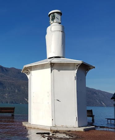
Date unknown. Active; focal plane about 7 m (23 ft); continuous (?) white light. 5 m (16 ft) cylindrical cast iron tower on a 1-story octagonal cast iron equipment shelter. Lighthouse painted white. Franck de la Savoie's closeup 2018 street view (seen at right) shows a small Fresnel lens in the lantern, Benoit Sigoure has a 2023 photo, Marc Lecuyer has a 2016 street view, Pascal Baudet has a street view and Google has a satellite view. A March 2016 photo accompanies an announcement that the lighthouse had been reactivated. Thierry Kergroac'h's 2013 photo shows an active light atop the tower, but not in the lantern seen now. Huelse has a historic postcard view and another postcard view showing an earlier light. The Lac du Bourget, the largest lake entirely in France, is located in the Alps about halfway between Grenoble and Genève, Switzerland. The lake is 18 km (11 mi) long and has an altitude of 231.5 m (760 ft). The resort town of Aix-les-Bains is on the east side of the lake. Located at the end of the main pier at the Grand Port d'Aix-les-Bains. Accessible by walking the pier. Site open, tower closed.

Grand Port Light, Aix-les-Bains, January 2018
Google Maps street view by Franck de la Savoie

Information available on lost lighthouses:

Notable faux lighthouses:

Adjoining pages: North: Switzerland | East: Liguria | South: Corsica | West: Le Var | Enclave: Monaco

Return to the Lighthouse Directory index | Ratings key

Posted April 7, 2006. Checked and revised April 19, 2024. Lighthouses: 34. Site copyright 2024 Russ Rowlett and the University of North Carolina at Chapel Hill.