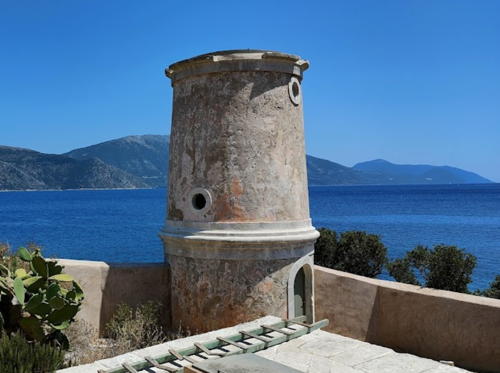
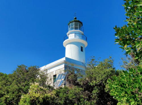
Lighthouses of Greece: Ionian Islands

The nation of Greece occupies a complex peninsula at the southeastern corner of Europe plus a large number of islands in the Aegean Sea to the east and the Ionian Sea to the west. The name Greece is of Roman origin (Graecia in Latin); the traditional name of the country is Hellas (Ἑλλάς) and its official name is the Hellenic Republic (Ελληνική Δημοκρατία, Ellinikí Demokratía).

The modern Greek nation is a relatively recent creation. After several centuries of rule by the Ottoman (Turkish) Empire southern Greece won its independence in a bitter struggle during the 1820s. When its independence was recognzied in 1830 Greece included the southern half of the Greek Peninsula plus the islands of the Cyclades. The nation expanded northward in several steps. Thessaly was ceded to Greece in 1881, Epirus and Macedonia were added after the Balkan Wars of 1912-13, and West Thrace became Greek in 1920.

The Ionian Islands lie in the Ionian Sea off the western coast of mainland Greece. There are seven major islands: Kérkyra (Corfu), Paxos, Antipaxos, Lefkada (Lefkos), Ithaki (Ithaca), Kefalonia (Cephalonia), and Zakynthos (Zante). These islands comprise one of the country's 13 administrative regions, called periferies (περιφέρειες). The region is divided into five districts called regional units (enótites, ενότητες).

The history of the islands is distinct from that of the Greek mainland. For many centuries they were controlled by Venice as outposts of its commercial empire, the Stato da Màr. Because of the long rule by Venice there is a strong Italian influence in the islands and they are often known by their Italian names. During the Napoleonic Wars they came under French rule but were later conquered by Britain. At the end of the wars in 1815 the Treaty of Paris left the British in control, administering the islands as a protectorate and using them as naval bases. The islands were finally transferred to Greece in 1864. Five of the lighthouses in the islands were built during the half century of British rule.

The island of Kythira, located off the southeastern corner of the Greek mainland, is also considered to be one of the Ionian Islands, but it is remote from the others and is attached to the region of Attica. Lighthouses of Kythira are listed on the Southern Greece page.

The Greek word for a lighthouse, pháros or fáros (φάρος), is the root for the words for lighthouse in many Western European languages. In Greek nisi is an island, ýfalos is a shoal or reef, akrotíri or ákra is a cape or headland, kolpós is a bay or gulf, ekvolí is an estuary, potámi is a river, and limáni is a port or harbor.

Lighthouses in Greece are maintained by the Hellenic Navy Lighthouse Service.

ARLHS numbers are from the ARLHS World List of Lights. Admiralty numbers are from volume N of the Admiralty List of Lights & Fog Signals. U.S. NGA List numbers are from Publication 113.

General Sources
Online List of Lights - Greece
Photos by various photographers posted by Alexander Trabas.
Lighthouse Service - Photographs
A large collection of unlabeled (!) photos of lighthouses.
Lighthouses in Greece
Aerial photos posted by Marinas.com.
Greece Lighthouses
Photos by Larry Myhre.
TrekEarth - Lighthouses of Greece
Photos by various contributors.
Leuchttürme an der griechischen Küste
Photos by various photographers posted by Bernd Claußen.
Lighthouses in Greece
Photos by various photographers available from Wikimedia.
World of Lighthouses - Greece
Photos by various photographers available from Lightphotos.net.
Greece Lighthouses
Photos by Larry Myhre.
GPS NavigationCharts
Navigational chart information for Greece.
Navionics Charts
Navigational chart for Greece.


Fiskárdo Light, Kefaloniá, September 2009
Flickr Creative Commons photo by Jim Damare


Gerogompos Light, Kefaloniá, January 2018
Google Maps photo by Panagiotis Kalogiros

Zákynthos (Zante) District Lighthouses
Third largest of the Ionian Islands, Zákynthos (Zante in Italian) is located due south of Kefalloniá and west of the northwestern Peloponnese. The island is accessible by air or by ferry from Killini on the mainland and from Argostóli, Kefalloniá. Its population is about 40,000. The island was ruled by Venice from 1485 to 1797.

Strofades (Strivali Islands, Stamfani)
1829 (British). Active; focal plane 39 m (128 ft); two white flashes every 15 s. 11 m (36 ft) square stone tower with lantern and gallery. The tower is unpainted stone; lantern painted green. An undated closeup photo is available and Bing has a distant satellite view. The lighthouse appears to be endangered by lack of maintenance. The Strofades are a small group of islands about 40 km (25 mi) south southeast of Cape Keri, the southern tip of Zákynthos. The largest island, Stamfani, is the site of a 14th century Orthodox monastery, now occupied by a single monk as a caretaker. Located at the western tip of Stamfani. Accessible only by boat. Site open, tower closed. ARLHS GRE-122; Admiralty N4004; NGA 14900.
** Skinári
1897. Active; focal plane 66 m (217 ft); white flash every 5 s. 9 m (30 ft) round rubblestone tower with lantern and gallery attached to the seaward side of a 1-story rubblestone keeper's house. The house is occupied by resident keepers. The lighthouse is unpainted stone; lantern painted white with a black roof. Didier Bonvin's photo is at right, Trabas has an excellent photo, Tomáš Hofman has a photo, Jakub Cholewik has a 2018 street view, the Navy has a photo of the light in action, and Google has a satellite view of the station. The lantern is clearly not the original. Comparison with Savas's photos suggests that the lighthouse has been restored and the lantern replaced since 2002. The area around the light station is well known for the "blue caves" cut into the limestone cliffs by the sea and for several historic stone windmills. Located on Cape Skinari, the northern tip of Zákynthos, about 1.5 km (1 mi) north of Korithi. Accessible by road. Site open; the keepers may be willing to conduct tours of the tower. . ARLHS GRE-119; Admiralty N3984; NGA 14724.
Ákra Kryonéri (Cape Krionero)
Date unknown (station established 1869). Active; focal plane 21 m (69 ft); two white flashes every 16 s. 8 m (26 ft) square concrete tower, painted white. Trabas has a photo and Google has a street view and a satellite view. This light marks the narrowest point of the passage between Zákynthos and the mainland. Located on a promontory on the southeastern side of the island. Site and tower closed (private property). ARLHS GRE-171; Admiralty N3986; NGA 14728.
* Zákynthos North Breakwater
Date unknown. Active; focal plane 11 m (36 ft); green flash every 1.5 s. 9 m (29 ft) post centered on a square 1-story equipment shelter standing on a square stepped platform. The lighthouse is unpainted white concrete with one green horizontal band. Trabas has a photo, Robert Rossi has a view from the sea, and Google has a street view and an indistinct satellite view. Located on the end of the north breakwater of Zákynthos harbor. Accessible by walking the pier, and there is a good view from ferries entering or leading the harbor. Site open, tower closed. Admiralty N3988; NGA 14737.
Kerí (Kerion)
1925. Active; focal plane 194 m (636 ft); white flash every 10 s. 7 m (23 ft) round cylindrical masonry tower with lantern and gallery attached to the seaward side of a 1-story masonry keeper's house. Lighthouse painted white, except the lantern roof is painted green. Trabas has a good photo, Wikimedia has a 2012 photo, a 2021 photo is available, and Google has a closeup street view and a satellite view of the lighthouse. The area is famous for its spectacular cliffs overlooking the Ionian Sea. Accessible by road (local guidance may be needed). Located on Cape Keri, the southern tip of Zákynthos, near the town of Kerí. Site and tower closed; the entrance is gated. ARLHS GRE-081; Admiralty N3990; NGA 14740.

Skinári Light, Zákynthos, June 2021
Google Maps photo by Didier Bonvin

Kefalloniá (Cephalonia) District Lighthouses
Kefalloniá, the largest of the Ionian Islands, is located off the entrance to the Gulf of Corinth. The island has a population of about 45,000 and is accessible by ferries from several locations on the mainland coast. The island was ruled by Venice from 1500 to 1797.
[Dhik Halia (Dihalia, Dekhalia) (3?)]
Date unknown (station established 1910). Active; focal plane 17 m (56 ft); two red flashes every 8 s. 5.5 m (18 ft) square skeletal tower mounted on a round cylindrical metal base, painted white with one red horizontal band. The active light stands just in front of the ruins of the original 1-story stone keeper's house. Kostas Annikas Deftereos has a 2021 closeup photo, Trabas has a distant photo, Myhre has a view from the sea, and Google has a satellite view. Old light lists indicate the light here has always been displayed from a skeletal or metal tower; the original tower was atop the keeper's house. The present light tower is at least the third, possibly the fourth. Located on a promontory marking the entrance to the bay of Sami, on the east side of the island, about 5 km (3 mi) northeast of the town of Sami. Accessible by hiking the service road. Site open, tower closed. ARLHS GRE-163; Admiralty N3870; NGA 14684.
* Argostóli (Ágios Theodoros, Ayious Theodorus) (2)
1960 (station established by the British in 1828). Active; focal plane 11 m (36 ft); white flash every 3 s. 9 m (30 ft) round cylindrical masonry tower surrounded by a Doric colonnade. No lantern; the light is mounted atop a domed structure. Entire lighthouse is white. Roman Šiška's 2023 photo is at right, Trabas has a great closeup, another good closeup photo is available, Marinas.com has aerial photos, Huelse has a historic postcard view, Kirk Hamlet has a street view and Google has a satellite view. The present structure is a replica of the original lighthouse, which was heavily damaged by an earthquake in 1953. Located on the east side of the Gulf of Argostóliou at the northwestern tip of a cape protecting the harbor of Argostóli. Accessible by road. Site open, tower closed. . ARLHS GRE-048; Admiralty N3890; NGA 14708.
Vardiani (Vardiánoí) (1)
1824 (British). Inactive for many years. Approx. 7 m (23 ft) square cylindrical stone tower attached to a small 1-story stone keeper's cottage. The abandoned buildings are crumbling into ruin. Google has a satellite view. This lighthouse was built to mark the entrance to the Gulf of Argostóliou, a protected bay on the southwest side of Kefalloniá that leads to the island's principal town, Argostóli. Heavily damaged by a 1953 earthquake, the lighthouse was replaced rather than repaired. Savas's statement that the lighthouse is accessible "by a difficult street" from Lixouri does not make any sense. Located on the southeast point of the island of Vardianoi, about 3 km (1.8 mi) southwest of the entrance to the Gulf of Argostóliou. Accessible only by boat. Site open, tower closed.

Ágios Theodoros Light, Argostóli, August 2023
Google Maps photo by Roman Šiška
Vardiani (Vardiánoi) (2)
Date unknown. Active; focal plane 11 m (36 ft); flash every 7.5 s, white or red depending on direction. 8 m (26 ft) round cylindrical concrete tower rising from a 1-story base. Michaela Rovenská has aa 2020 closeup photo, Trabas has a very distant view from the sea, and Google has a satellite view. Located on the southeast point of the island of Vardhiánoi, about 3 km (1.8 mi) southwest of the entrance to the Gulf of Argostóliou. Accessible only by boat. Site status unknown. ARLHS GRE-186; Admiralty N3882; NGA 14704.
* Gerogompos (Ákra Yerogómbos) (2)
1947 (station established 1907). Active; focal plane 58 m (190 ft); white light, 3 s on, 2 s off, 3 s on, 7 s off. 13 m (43 ft) round cylindrical masonry tower with lantern and gallery attached to the seaward side of a 1-story keeper's house. Entire lighthouse painted white, except the lantern dome is gray metallic. Panagiotis Kalogiros has a 2018 closeup (also seen at the top of this page), Trabas has a closeup photo, another fine closeup and a 2022 photo are available, the Navy has a photo, and Google has a satellite view. The original lighthouse was destroyed by retreating German troops late in World War II; it was replaced using the same plans as the original. Located on a promontory at the southwestern tip of Kefalloniá, about 12 km (7.5 mi) west of Lixouri. Accessible by an unpaved road but the entrance is unmarked. Site open, tower closed. . ARLHS GRE-132; Admiralty N3880; NGA 14720.
*** Fiskárdo (1)
16th century (?) (Venetian). Inactive since 1892 at least. Approx. 6 m (20 ft) round masonry tower. Adjacent to the lighthouse is a 1-story keeper's house. Szymon Banaszczyk's photo is at right, Stéphane-Aristide Zissis has a 2018 photo, Daniel Earl's photo shows that it is possible to climb the tower, and Google has a satellite view. We need information on the history of this lighthouse. The keeper's house appears to date from the 19th century, so it may be that the British refurbished the lighthouse during their administration of the Ionian Islands (1809-1864). Located on a promontory on the east side of Kefalloniá's northern tip, marking the entrance to the channel between Kefalloniá and the neighboring, smaller island of Itháki (Ithaka). Accessible by a hiking trail, about 1.5 km (1 mi) long, from a popular viewpoint on the north side of Fiskardo Bay; the entrance is marked with a small sign. Site open, tower open to all comers (caution advised!). .

Venetian lighthouse at Fiskárdo, Kefalloniá, July 2021
Google Maps photo by Szymon Banaszczyk
* Fiskárdo (2)
1892. Active; focal plane 28 m (92 ft); white flash every 3 s. 14 m (46 ft) square stone tower with lantern and gallery. The lighthouse is unpainted light gray stone; the lantern dome is gray metallic. Jim Damare's photo is at the top of this page, Trabas has a photo, Kirsty Sarah Tuxford also has a closeup photo, Myhre has a view from the sea, Antonis Tvlink has a distant street view, and Google has a satellite view. Located a short distance uphill from the Venetian lighthouse. Accessible by a hike of about 1.5 km (1 mi). Site open, tower closed. ARLHS GRE-065; Admiralty N3876; NGA 14672.

Itháki (Ithaca) District Lighthouses
The island of Itháki, better known as Ithaca in English, is located just off the northeastern coast of Kefalloniá. The island is about 25 km (15 mi) long but less than 8 km (5 mi) wide. The population is about 3300. The island was ruled by Venice from 1503 to 1797.

Oxeiá (Oxía, Oksia)
1899. Active; focal plane 70 m (230 ft); two white flashes every 15 s. 8 m (26 ft) round rubblestone tower with lantern and gallery, attached to the seaward side of a 2-story keeper's house. The tower and lower story of the house are unpainted rubblestone; the lantern and upper story of the house are painted white, and the lantern roof is green. The upper story of the house is dissimilar to the lower and must have been added well after the original construction. Konstantinos Charalampakis has a 2022 drone view, Alexandros Gialias has a photo, Trabas has Peter Doll's distant view from the sea, and Google has a satellite view. Oxeiá is a small island at the north entrance to the Gulf of Patras, which leads to the Gulf of Corinth. Despite its close proximity to the mainland Oxeía is administered as part of the Itháki (Ithaca) municipality in the Ionian Islands Region. Located at the southern tip of the island. Accessible only by boat, although transportation can be arranged from Astakos on the nearby mainland. Site open, tower closed. ARLHS GRE-101; Admiralty N3908; NGA 14640.
Ákra Far'Aetós (Akra Pisaetou)
Date unknown. Active; focal plane 19 m (62 ft); white flash every 5 s. 4 m (13 ft) round white lantern on a concrete base. Trabas has a view from the sea and Google has an indistinct satellite view. Located on a headland on the central west coast of Itháki. Site status unknown. Admiralty N3866; NGA 14644.
 

Lefkáda (Lefkas, Leucas) District Lighthouse
The island of Lefkáda, better known as Lefkas or Leucas in English, is located just off the mainland coast south of Preveza. It is the only one of the Ionian Islands accessible from the mainland by a bridge. The Lefkáda Lighthouse is on the mainland side of the bridge, so it is described on the Northern Greece page. Lefkada was ruled by the Ottoman Empire from 1479 to 1718 and then by Venice until 1797.

Vrachonisída Formíkoula (Nisis Formikoula)
Date unknown. Active; focal plane 17 m (56 ft); flash every 4 s, white or red depending on direction. 4 m (13 ft) round white lantern. Dávid Juraj Szücs has a photo and Google has a satellite view. The light is an important guide for ships in the island-strewn waters between Ithaca, Lefkada, and the mainland. Located on a small island marking the passage between the islands of Meganisi and Kálamos southeast of Lefkada. Accessible only by boat. Site open, tower closed. Admiralty N3846; NGA 14612.
* Ákra Doukáto (Dukato, Cape Lefkada)
1890. Active; focal plane 70 m (230 ft); white flash every 10 s. 15 m (49 ft) round cylindrical concrete tower with lantern and gallery, rising from a 1-story keeper's house. Entire lighthouse painted white. A photo is at right, Trabas has a good photo by Eckhard Meyer, Neil Merton has posted a closeup photo, the Navy has a photo, Myhre has a view from the sea, Elliott Langmead has another view from the sea, David Prochazka has a 2017 street view, and Google has a satellite view. The light station stands atop a spectacular cliff at the southern tip of Lefkáda, commanding a view of the islands of Ithiki and Kefalloniá. According to legend the poet Sappho leaped to her death from this cliff around 570 BCE. Located at the southwestern tip of Lefkáda, about 50 km (30 mi) south southwest of the town of Lefkada. Accessible by road; parking available. Site open, tower closed. . ARLHS GRE-060; Admiralty N3836; NGA 14572.

Ákra Doukáto Light, Lefkáda, July 2011
Flickr Creative Commons photo by christsiav

Kérkyra District: Paxi (Paxoí, Paxos) Lighthouses
The municipality of Paxi (Paxoi) includes two small islands, Paxos and Antipaxos, located 12 km (7.5 mi) due south of the southern tip of Kérkyra. The islands are accessible by ferry from Parga. As a dependency of Kérkyra Paxi was ruled by Venice from 1386 to 1797.
** Antipaxos (Antipaxoí, Ákra Ovorós, Cape Oboros)
1906. Active; focal plane 41 m (135 ft); white or red light, depending on direction, on 1.5 s, off 4.5 s. 12 m (39 ft) square rubblestone tower with lantern and gallery attached to a small 1-story rubblestone keeper's cottage. The lighthouse is unpainted; lantern painted white with a green roof. A closeup and a 2009 view from the sea are available, Claußen also has a view from the sea by Olaf Riesenberg, Marinas.com has aerial photos, and Google has a satellite view. Antipaxos is a small island about 2.5 km (1.5 mi) southeast of Paxos. Boat transportation to the island can be arranged in Gaios, the principal town of Paxos. The lighthouse is staffed and the keeper is reported to conduct tours by arrangement. Located at the southeastern tip of the island. Site open, tower open by arrangement. ARLHS GRE-100; Admiralty N3796; NGA 14496.
Panagía (Panayia, Port Gayo)
1825 (British). Active; focal plane 26 m (85 ft); flash every 5 s, white or red depending on direction. 11 m (36 ft) square cylindrical stone tower with lantern and gallery, attached to a keeper's house. Lighthouse painted white, lantern roof dark green. The Navy has a closeup, Google Maps has the same photo, Claußen has photos by Olaf Riesenberg, Ioannis Petrou has a 2023 closeup, and Google has a satellite view. Panagia is a small island off the north side of the entrance to the harbor of Gaios; the island is also the site of a historic monastery, the Moni Panagias. Transportation to the island is available from Gaios. Located at a high point at the northeastern end of the island. Site open, tower closed. ARLHS GRE-102; Admiralty N3794; NGA 14488.
* Lákka (Laka) (2)
1919 (station established 1825). Active; focal plane 64 m (210 ft); three white flashes every 24 s. 10 m (33 ft) square rubblestone tower with lantern and gallery, attached to a small 1-story rubblestone keeper's cottage. The lighthouse is unpainted; lantern painted white with a green roof. A photo is at right, a page for the lighthouses has photos, Efi Labropoulou has a 2021 closeup, Giannis Koskinas has a nice 2020 photo, Phil James has a 2008 photo, and Google has a street view and a satellite view. The lighthouse is located near Lakka at the northwestern tip of the island, about 9 km (5.5 mi) northwest of Gaios, the principal town and ferry port. Accessible by road. Site open, tower closed. . ARLHS GRE-088; Admiralty N3792; NGA 14484.

Laka Light, Paxi, April 2018
Google Maps photo by minimal mentor


Kérkyra District: Kérkyra (Corfu) Lighthouses
Kérkyra was long known (and may still be better known) by its Italian name Corfu. The northernmost of the Ionian Islands, it lies off the northwestern corner of Greece and the southwestern corner of Albania. The island is 60 km (40 mi) long. It is accessible by air and by high-speed ferries from Igoumenítsa in Epirus and from Sarandë in neighboring Albania. Under the name Corfu Kérkyra was ruled by Venice from 1386 to 1797 and served as the capital of Venice's maritime empire.
Peristeres (Peristeraí, Tignoso) (2)
1872 (station established 1825). Active; focal plane 23 m (75 ft); red flash every 5 s. 10 m (33 ft) round cylindrical stone tower with gallery, attached to a small 1-story stone keeper's cottage. The lighthouse is unpainted, and it appears in very poor condition in Savas's photo; the keeper's house is in ruins. A 2021 closeup photo is available, a 2016 photo by Giovanni Marques Ramos, taken from the sea, shows the mountains of southern Albania in the distance, the Navy has a good view from the sea, Dean Smethurst has a photo, Claußen has photos by Olaf Riesenberg, Trabas has a very distant view, and Google has a satellite view. Located on a rocky islet off the northeastern tip of Kérkyra, marking the entrance to the channel between the Greek island and the Albanian mainland. Accessible only by boat. Site and tower closed. ARLHS GRE-106; Admiralty N3750; NGA 14392.
[Ýfalos Sérpa]
Date unknown. Active; focal plane 12 m (39 ft); white light, characteristic unknown. 12 m (39 ft) skeletal mast atop a large round platform supported by four piles. Trabas has a photo and Bing has a satellite view. Located on a reef off the northeastern tip of Kérkyra, about 2.5 km (1.5 mi) south of the Peristeres lighthouse. Accessible only by boat. Site and tower closed. Admiralty N3754.5.; NGA 14398.
* Sidero (Sideros, Akra Sidero, Kérkyra, Corfu)
1828 (British). Active; focal plane 78 m (256 ft); two white flashes every 6 s. 8 m (26 ft) round stone tower with lantern and gallery, attached to a small 1-story stone keeper's cottage. The lighthouse is unpainted; the lantern roof is green. Larry Myhre's 2009 photo is at right, Claußen has photos by Olaf Riesenberg, Steven dos Remedios has a nice view, Trabas has Andreas Köhler's view, Klaus Huelse has a historic postcard view, Jim Gayes has a street view, and Google has a satellite view. Endangered by poor maintenance. Myhre's photo at right and a March 2006 closeup show the poor condition of this historic lighthouse: the crumbling tile roof and a pane missing from the lantern. Benny Hünersen's September 2013 photo doesn't show much improvement, and the lighthouse stills look to be in poor condition in René Sobota's 2023 photo. The lighthouse was built by the British to light the way to their principal naval base in the Ionian Islands. It stands at the east end of the town of Kérkyra within the Venetian citadel, which withstood repeated sieges by the Turks. Note: there is another Faros Sidero on Kriti (Crete). Site open, tower closed. . ARLHS GRE-117; Admiralty N3756; NGA 14430.
Sidero Light
Sidero Light, Kérkyra, May 2009
Flickr Creative Commons photo by Larry Myhre
[Levkimnis (Salternes)]
Date unknown (station established 1874). Inactive since 2020. 5 m (17 ft) square skeletal tower painted white. Next to the modern light is a small 1-story stone keeper's cottage; the light was originally displayed from a post atop the cottage. Trabas has a distant view of the light tower and Google has an indistinct satellite view. Located on Akra Levkimnis, a point of land on the southeastern side of the island, about 2.5 km (1.5 mi) northeast of Alikes. Site status unknown. ex-Admiralty N3776; NGA 14436.
* Kastri (Othoni, Othonoí, Fano) (1)
1872. Active or reactivated (?); focal plane 103 m (338 ft); white flash every 10 s. 13 m (43 ft) round masonry tower with lantern and gallery centered on a 1-story masonry keeper's house. Lighthouse painted white. A 2020 photo by Panayotis Ioannidis is at right, Spiros Katehis has a 2019 photo, Pierros Zevolis has a closeup, Marinas.com has aerial photos, and Google has a satellite view. NGA now describes the light as a 10 m (33 ft) "round metal tower on house" but the available photos do not show such a tower and the lighthouse appears to be in service. Othonoí (Fano in Italian), the westernmost Greek territory, is an island about 6 km (3.5 mi) long and about 25 km (15 mi) northwest of Kérkyra. The island has a population of about 400 and is accessible by ferry from the town of Kérkyra. Located on the northeastern point of the island. Site open, tower closed. ARLHS GRE-078; Admiralty N3747; NGA 14380.

Information available on lost lighthouses:

Notable faux lighthouses:


Kastri Light, Othonoí, September 2020
Google Maps photo by Panayotis Ioannidis

Adjoining pages: North: Albania | East: Northern Greece | Southeast: Southern Greece

Return to the Lighthouse Directory index | Ratings key

Posted November 27, 2006. Checked and revised November 7, 2023. Lighthouses: 21. Site copyright 2023 Russ Rowlett and the University of North Carolina at Chapel Hill.