Lighthouses of Southern Greece

The nation of Greece occupies a complex peninsula at the southeastern corner of Europe plus a large number of islands in the Aegean Sea to the east and the Ionian Sea to the west. The name Greece is of Roman origin (Graecia in Latin); the traditional name of the country is Hellas (Ἑλλάς) and its official name is the Hellenic Republic (Ελληνική Δημοκρατία, Ellinikí Demokratía).

The modern Greek nation is a relatively recent creation. After several centuries of rule by the Ottoman (Turkish) Empire southern Greece won its independence in a bitter struggle during the 1820s. When its independence was recognzied in 1830 Greece included the southern half of the Greek Peninsula plus the islands of the Cyclades. The nation expanded northward in several steps. The Ionian Islands were added in 1864 and Thessaly in 1881. Epirus and Macedonia were added after the Balkan Wars of 1912-13 and West Thrace became Greek in 1920.

Greece is divided into thirteen administrative regions called periferies (περιφέρειες) and the periferies are subdivided into districts called regional units (enótites, ενότητες). This page covers lighthouses of the southern mainland of Greece, including the Attica region (the Athens area), the Peloponnese region, and the portion of the West Greece region south of the Gulf of Corinth. Also included are lighthouses of nearby islands, in particular Kythira and Antikythira. Lighthouses of regions north of Attica and the Gulf of Corinth are listed on the Northern Greece page. There are separate pages for the Ionian Islands, for Crete, and for the Aegean Islands.

The Greek word for a lighthouse, pháros or fáros (φάρος), is the root for the words for lighthouse in many Western European languages. In Greek nisi is an island, ýfalos is a shoal or reef, akrotíri or ákra is a cape or headland, kolpós is a bay or gulf, ekvolí is an estuary, potámi is a river, and limáni is a port or harbor.

Lighthouses in Greece are maintained by the Hellenic Navy Lighthouse Service.

ARLHS numbers are from the ARLHS World List of Lights. Admiralty numbers are from volume N of the Admiralty List of Lights & Fog Signals. U.S. NGA List numbers are from Publication 113.

General Sources
Lighthouses of Greece
A comprehensive site posted by amateur radio operator Pavlidis Savas (SV2AEL); it includes data and photos for 120 traditional Greek lighthouses.
Lighthouse Service - Photographs
A large collection of unlabeled (!) photos of lighthouses.
Online List of Lights - Greece
Photos by various photographers posted by Alexander Trabas.
Lighthouses in Greece
Aerial photos posted by Marinas.com.
Lighthouses in Greece
Photos available from Wikimedia.
World of Lighthouses - Greece
Photos by various photographers available from Lightphotos.net.
Greece Lighthouses
Photos by Larry Myhre.
Leuchttürme an der griechischen Küste
Photos by various photographers posted by Bernd Claußen.
GPS NavigationCharts
Navigational chart information for Greece.
Navionics Charts
Navigational chart for Greece.


Psitalia Light, Piraeus, June 2018
Google Maps photo by Christos Kazantzoglou

Attica Region: Athens Area Lighthouses

East Attica District: Gulf of Euboea Lighthouse
* Ormos Oropou
Date unknown. Active; focal plane 6 m (20 ft); white flash every 4 s. 4 m (13 ft) round lantern mounted on a square masonry base. Trabas has Eckhard Meyer's closeup photo, Nikos Tsatsakis has a 2015 photo, and Google has a street view and a satellite view. Located on the beach, just off the coastal road, on a prominent cape about 1.6 km (1 mi) northeast of Skala Oropou and due north of Athens. Site open, tower closed. Admiralty N4360; NGA 16296.
Verdougi (Berdugi) Islets
1884. Inactive for many years. 8 m (26 ft) square stone tower rising from a 1-story stone keeper's house. Lantern removed. A photo by Capt. Peter Mosselberger is at right, a 2023 view is available, Giorgos Russos has a view from the sea, and Google has a satellite view. The Verdougi Islets are a group of four small islands off Agia Marina, between the Attic mainland and Eoboea; they separate the Petalion Gulf to the south from the Euboean Gulf to the north. The lighthouse has been replaced by beacons on the islets at the ends of the group. Located atop Parthenope, the largest of the islands; the focal plane was 71 m (234 ft). Accessible only by boat. Site status unknown.
[Vrachonisída Lígeía (Verdougi Southeast)]
Date unknown. Active; focal plane 10 m (33 ft); two white flashes every 16 s. 5.5 m (18 ft) square skeletal tower. Trabas has a photo by Capt. Peter Mosselberger and Bing has a satellite view. The light at the northwest end of the islands is even smaller. Located on a tiny islet at the southwestern end of the Verdougi Islets. Accessible only by boat. Site open, tower closed. Admiralty N4352; NGA 16280.

Verdougi Islets Light, August 2015
photo copyright Capt. Peter Mosselberger; used by permission

East Attica District: Petalion Gulf and Cape Sounion Lighthouses
[Nisída Ráftis]
Date unknown. Active; focal plane 100 m (328 ft); white flash every 2 s. 7 m (23 ft) square skeletal tower. Next to the light is a ruined 2nd century AD statue. A closeup photo (second photo on the page) is available, Trabas has a very distant view, Giorgos Russos also has a distant view from the sea, and Google has a satellite view. The statue is of a female believed to represent the goddess Artemis. Located atop Ráftis, an island at the entrance to the bay of Porto Rafti, a resort town on the west shore of the Petalion Gulf. Accessible only by boat. Site open, tower closed. Admiralty N4346.4; NGA 16252.
* Vrisaki (Lavrio)
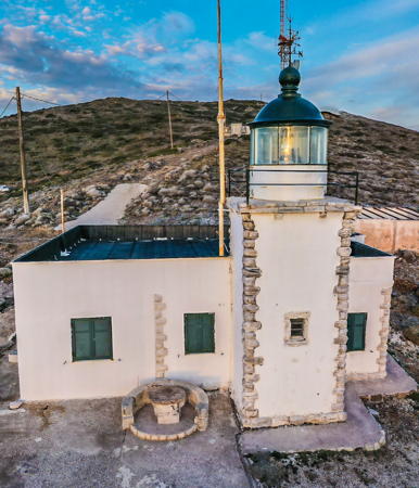
1892. Active; focal plane 23 m (75 ft); white flash every 5 s. 7 m (23 ft) square cylindrical stone tower with lantern and gallery, rising from a 1-story masonry keeper's house. Lighthouse painted white; lantern dome is blue. A 2020 drone view is at right, Trabas has Eckhard Meyer's closeup photo, Dimitris Stathakos has a 2018 photo, Marita Kaloglou has a closeup street view, and Google has a satellite view. Ships rounding Ákra (Cape) Soúnion, the eastern tip of the Attic peninsula, sail north through a channel between the mainland and the island of Makronisi ("Big Island"). Located on Ákra Vrisaki, marking the west side of the northern entrance to the Makronisi channel, about 5 km (3 mi) north of Lavrio. Site open, tower closed. . ARLHS GRE-131; Admiralty N4210; NGA 15620.
* [Ákra Fonias (1)]
1889. Inactive. Now in ruins, this lighthouse had a stone tower atop a 1-story stone keeper's house. Portions of the house walls are standing. Orestis Pad has a 2022 photo, there's a street view by Marita Kaloglou and Google has a satellite view. Trabas has a photo of the active light (focal plane 13 m (43 ft); white flash every 2.4 s) on a white skeletal tower. Located on Ákra Fonias, on the west (mainland) side of the Makronisi channel at the narrowest point, about 4 km (2.5 mi) south of Lavrio and 8 km (5 mi) northeast of Ákra Sounion. Site open. ARLHS GRE-067; Admiralty N4208; NGA 15612.
Agios Georgios (2?)
Date unknown (station established 1901). Active; focal plane 145 m (476 ft); two white flashes every 15 s. 10 m (33 ft) round white lantern mounted atop the ruins of a former keeper's house. Trabas has a photo by Capt. Peter Mosselberger and Google has a satellite view. Agios Georgios (St. George) is a small island in the center of the entrance to the Saronic Gulf and Athens, about 20 km (13 mi) south southwest of Cape Sounion. The island is uninhabited but in recent years it has become the site of a large windfarm. Located on the southeastern tip of the island. Accessible only by boat. Site and tower closed. Admiralty N4136; NGA 15224.

Vrisaki Light, Lavrio, December 2020
Google Maps drone view by Chromolia “Chromolia com” com
 

Pireaus District Lighthouses
Pireaus, the seaport of Athens, is located 8 km (5 mi) southwest of the center city along the east side of the Saronic Gulf. The city is the largest port of Greece and (thanks to cruise ships and ferries to the islands of the Aegean) one of the largest passenger ports in the world.

Piraeus Molos Themistokleus
Date unknown. Active; focal plane 14 m (46 ft); green light, 2 s on, 4 s off. 10 m (33 ft) round cylindrical concrete tower, painted white with one green horizontal band. Trabas has Rainer Arndt's photo, Myhre has a closeup photo, and Bing has a satellite view. Located at the end of the south breakwater mole at the entrance to the inner harbor of Piraeus. Site status unknown. Admiralty N4178; NGA 15524.
* Piraeus Molos Vasileus Georgios (2)
Date unknown. Active; focal plane 14 m (46 ft); red light, 2 s on, 4 s off. 10 m (33 ft) round cylindrical concrete tower, painted white with one red horizontal band. Trabas Rainer Arndt's photo and Google has a satellite view. Myhre's 2009 photo shows the earlier tower. It was replaced by a similar tower after its base was damaged by the cruise ship MSC Magnifica in November 2013. Located at the end of the north breakwater mole at the entrance to the inner harbor of Piraeus. Accessible by walking the mole. Site open, tower closed. Admiralty N4180; NGA 15528.
Ákra Keos Molos (Drapetsonas)
Date unknown. Active; focal plane 14 m (46 ft); two green flashes every 10 s. Approx. 11 m (36 ft) concrete post topped by a round lantern room with gallery; the active light is mounted on the roof. The lighthouse is unpainted white concrete with one green horizontal band. Bass Dimou's photo is at right, Trabas has a closeup photo, Iordanis Keramidas has a 2008 closeup, a view from the water is available, and Google has a street view and a satellite view. The lighthouse was restored and repainted in 2009. Located at the end of a mole extending from Ákra Keos, a cape in Piraeus directly opposite the Psitalia lighthouse. Site and tower closed. Admiralty N4171.5; NGA 15384.

Akra Keos Molos Light, Piraeus, March 2009
Google Maps photo by Bass Dimou
Psitalia (Psyttáleia)
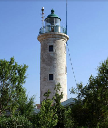
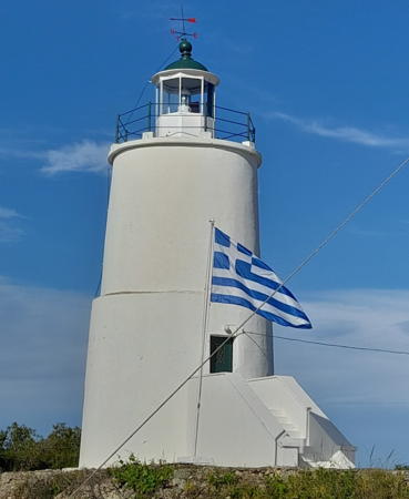
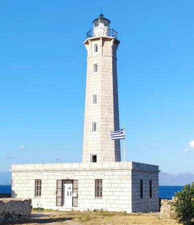
1856. Active; focal plane 47 m (154 ft); two white flashes every 15 s. 14 m (46 ft) round cylindrical stone tower with lantern and gallery, attached to a 1-story stone keeper's house. 4th order Fresnel lens in use. The lighthouse is unpainted white stone; lantern dome painted green. Christos Kazantzoglou's photo is seen at the top of this page, Trabas also has a photo, Myhre has a view from the harbor, and Bing has a satellite view. This is the traditional landfall light for Piraeus. Psitalia is a small island in the harbor of Piraeus, between the waterfront and Salamina. The island is the site of large sewage and hazardous waste treatment plant and is probably not open to the public. Located at the eastern tip of the island. Site status unknown. ARLHS GRE-115; Admiralty N4170; NGA 15376.
Fylatouri (Ákra Fylatouri)
Date unknown. Active; focal plane 13 m (43 ft); two white flashes every 14 s. Approx. 10 m (33 ft) two-story keeper's house with a short square light tower at one corner. Lighthouse painted white. Trabas has a distant view and Bing has a satellite view. Located on a cape about 3 km (2 mi) northwest of Pérama, marking the northern entrance to the strait separating Salamina from the mainland. Site status unknown. Admiralty N4174; NGA 15476.

Attica Region: Islands District Lighthouses

The Islands District includes the islands of the Saronic Gulf, a broad inlet of the Aegean Sea separating the Attic Peninsula from the Argolid Peninsula of the Peloponnese. It also includes several islands lying off the end of the Argolid Peninsula, several small unihabited islands off the east coast of the Peloponnese, and, far to the south, the islands of Kythira and Antikythira that were formerly part of the British territory of the Ionian Islands during much of the nineteenth century.

Salamina (Salamis) Municipality Lighthouse
Salamína (Salamis), the traditional home of the Hellenic Navy, is a large island in the northern end of the Saronic Gulf, just west of Piraeus. It is famous as the site of a Greek naval victory over Persia in 480 BCE.

*
Koghi (Kokhi, Kónkhi, Salamina)
1901. Active; focal plane 33 m (108 ft); white flash every 4 s. 12 m (39 ft) round cylindrical stone tower with lantern and gallery, centered on a 1-story stone keeper's house. The lighthouse is unpainted; lantern painted white with a green dome. A Navy photo is at right, Trabas also has a good photo, Stamatia Tselikou has a 2020 photo, Marinas.com has aerial photos, Marita Kaloglou has a street view, and Google has a satellite view. The island is easily accessible from the mainland by ferries. Located at the southern tip of the island, about 1.5 km (1 mi) southeast of Kolones. Accessible by road. Site open, tower closed. . ARLHS GRE-084; Admiralty N4168; NGA 15324.

Ákra Kokhi Light, Salamina
Hellenic Navy photo

Aegina and Poros Municipalities Lighthouses
These islands, located in the Saronic Gulf southwest of Athens, are governed as municipalities of the Islands District.
Plakakia (Aigina, Aegina, Egina)
1881. Active; focal plane 11 m (36 ft); two white flashes every 15 s. Post mounted atop a 6 m (20 ft) round stone tower. Lighthouse painted white. Trabas has a closeup, Vasilis Sideris has a 2022 photo, and Google has a street view and a satellite view. Located at the western tip of Aegina, an island in the middle of the Saronic Gulf. The island is readily accessible by ferry from Piraeus and several other locations, and the lighthouse is accessible by road. Site open, tower closed. ARLHS GRE-108; Admiralty N4144; NGA 15252.
* Dana (Ákra Ntána, Poros) (1)
1870. Reactivated; focal plane 31 m (102 ft); flash every 4 s, white or red depending on direction. 9 m (30 ft) square cylindrical stone tower with lantern and gallery, rising from a 1-story stone keeper's house. The lighthouse is unpainted; lantern dome painted red. The light was moved to a square skeletal tower next to the lighthouse; this tower was apparently removed in 2012-13 and the light returned to the historic lighthouse. A 2022 photo is at right, Chris Brooks has a photo, Brent Koppenhaver has a photo, Dimitris Katsoulas has a 2021 photo, Trabas has a drone view, Wikimedia has a view from the sea by Georgios Pazios, and Google has a satellite view. The island of Poros lies at the southern end of the Saronic Gulf, just off the coast of the Peloponnese. Located at the western tip of the island, marking the entrance to the narrow strait between Poros and the mainland. Site open, tower closed. ARLHS GRE-058; Admiralty N4140; NGA 15228.
* Ákra Stavros
Date unknown. Active; focal plane 7 m (23 ft); flash every 3 s, red or green depending on direction. 7 m (23 ft) structure: a short triangular skeletal tower formerly mounted at one corner of a 1-story building that may or may not be a former keeper's cottage. The light is seen behind the church in Nick Cook's 2017 photo. A later photo by Trabas showed the tower leaning precariously from the structure. Trabas now has Eckhard Meyer's photo showing the light moved next to the building and Google has a satellite view. Located at the southern tip of the island of Poros, guiding vessels entering the narrow strait between the island and the mainland. Site open, tower closed. Admiralty N4141; NGA 15236.

Dana Light, Poros, September 2022
Google Maps photo by Sweet Salt

Hydra Municipality Lighthouses
Although the neighboring mainland is part of the county of Argolida and the Peloponnese region, these islands are governed as the Hydra municipality of the Islands District of the Attica Region.

Zourvas (Zurva) (2)
1946 (station established 1883). Active; focal plane 36 m (118 ft); three white flashes every 20 s. Approx. 9 m (30 ft) square cylindrical stone tower rising from a 1-story stone keeper's cottage. The house is unpainted stone with white trim; lantern painted white with a green dome. Michael Kalafatas has a closeup 2022 photo, a 2020 photo is available, George Morochartzis has a 2018 drone view, the Navy has a view from the sea, and Google has a satellite view. This is a copy of the original lighthouse, which was destroyed by German troops during World War II. Located at the eastern tip of Hydra, about 10 km (6 mi) east of Idra (Hydra), the largest town of the island. Practically inaccessible. Site and tower closed. ARLHS GRE-133; Admiralty N4134; NGA 15216.
Dokós
1923. Active; focal plane 23 m (75 ft); two flashes every 12 s, white or red depending on direction. 9 m (30 ft) round stone tower with lantern and gallery, attached to a 1-story stone keeper's house. Nikos Dritsakis has a photo, Thierry Flahaut has a view from the sea and Google has a satellite view. The keeper's house is unroofed and falling into ruin. Dokos (Dhokós) is one of the Saronic Islands, just off the east coast of the Peloponnisos about 8 km (5 mi) southeast of Ermioni. Attached to the Hydra municipality, the island is uninhabited except for a small Orthodox monastery. Located at the eastern tip of the island. Site status unknown. ARLHS GRE-059; Admiralty N4124; NGA 15196.

Spetses Municipality Lighthouses
Spetses is an island in the eastern entrance to the Argolikos Kolpos (Argolic Gulf). The island is about 7 km (4.5 mi) long by 3 km (2 mi) wide and has a population of about 3500. A popular tourist destination, Spetses is accessible by ferry from Piraeus or Kosta.

* Spetses (2)
1885 (station established 1837). Active; focal plane 27 m (89 ft); flash every 5 s, white or red depending on direction. 10 m (33 ft) 2-stage round old-style masonry tower with lantern and gallery. Lighthouse painted white with green trim; lantern dome is green. A 2023 photo is at right, Dimitrs Kourtidis has a 2021 photo, a 2009 view is available, Hans Baake has a 2018 closeup, the Navy has a good photo, and Google has a satellite view. Located on a promontory sheltering the east side of the harbor of Spetses. Site open, tower closed. . ARLHS GRE-063; Admiralty N4100; NGA 15176.
Velopoula (Belopoúla, Parapola)
1884. Active; focal plane 112 m (367 ft); two white flashes every 20 s. 10 m (33 ft) octagonal masonry tower with lantern and gallery, rising from a small square 1-story keeper's house. The lighthouse is painted white in Savas's photo. Trabas has Capt. Peter Mosselberger's 2015 closeup photo, Tomas Holec has a distant view from the sea, and Bing has a satellite view. Velopoula is an isolated, uninhabited island about 27 km (17 mi) off the southeastern peninsula of the Peloponnisos; it is attached administratively to the municipality of Spetses. Located atop the island. Accessible only by boat. Site and tower closed. ARLHS GRE-027; Admiralty N4090; NGA 15088.
Falkonera
Date unknown. Active; focal plane 136 m (446 ft); white flash every 5 s. 4 m (13 ft) round white lantern mounted on a stone base. Amateur radio operator SV1HER has a closeup photo (1/3 the way down the page), Trabas has a distant view by Capt. Theo Hinrichs, and Google has a distant satellite view. Falkonera is a small uninhabited island far out in the Aegean Sea, about 40 km (25 mi) east southeast of Velopoula. This is much closer to the Cyclades Islands than it is to the Greek mainland. The isolated island has been the scene of many shipwrecks, including the 1966 wreck of the ferry Heraklion which resulted in the loss of 217 lives. Located on heights at the southeastern end of the island. Accessible only by boat. Site open, tower closed. ARLHS GRE-012; Admiralty N4088; NGA 15084.

Spetses Light, Spetses, April 2023
Google Maps photo by Syl. Stalone

Kythira Municipality Lighthouses
Kythira (also spelled Cythera, Kithira or Kythera) is an island about 12 km (7.5 mi) off the southeastern tip of the Peloponnisos. Historically and culturally it is associated with the Ionian Islands, although it is remote from them geographically. Like the Ionian Islands it was administered by Britain from 1809 to 1864. The island has a population of about 3500 and is accessible by ferry from Gythio or Neapoli. Antikythira is a small island roughly halfway between Kythira and the northwestern tip of Crete. Kythira and Antikythira are administered as a municipality of the Attica region.

Apolitares (Antikythira, Andikíthira)
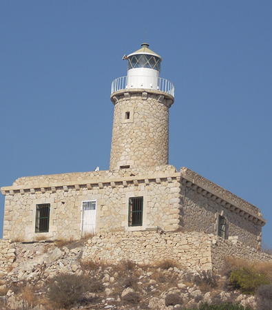
1926. Active; focal plane 40 m (131 ft); two white flashes every 15 s. 23 m (75 ft) 2-stage round stone tower, lower stage cylindrical and upper stage conical, with lantern and gallery, attached to the seaward end of a 1-story stone keeper's house. The tower is unpainted; lantern painted white with a green roof; keeper's house painted white. Christos Barboutis has the photo seen at right, Nikos Athanasopoulos has a 2022 photo, Angelos Kynigalakis has an aerial photo, Trabas has Capt. Peter Mosselberger's photo, and Google has a satellite view. This lighthouse is an important guide to vessels in the Antikythira Strait, which connects the Mediterranean and Aegean Seas northwest of Crete. Antikythira has a population of about 50. Boat transportation from Kythira can be arranged. Located at the southern tip of the island. Site open, tower closed. ARLHS GRE-040; Admiralty N4072; NGA 15076.
[Ákra Kástro]
Date unknown. Active; focal plane 31 m (102 ft); white flash every 5 s. 4 m (13 ft) square skeletal tower on a concrete base. No photo available but Google has a satellite view. Located on a headland on the east side of the entrance to a protected bay on the north coast of Antikythira. Site status unknown. Admiralty N4072.4; NGA 15080.


Apolitares Light, Antikythira, September 2017
Google Maps photo (by Christos Barboutis

* Kapsali
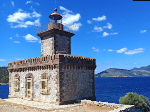
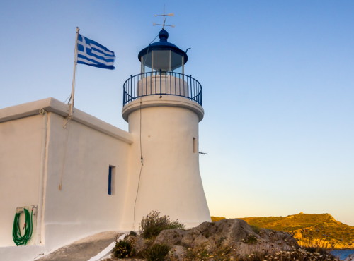
1853 (British). Active; focal plane 24 m (79 ft); white flash every 3 s. 8 m (26 ft) round cylindrical masonry tower with lantern and gallery, rising from a small 1-story masonry keeper's house. Entire lighthouse painted white, except the lantern dome is blue. A photo is at right, Trabas has a closeup photo, Giorgos Russos has another good photo, Nikos Dritsakis has a 2022 photo, Stuefi Ber has a street view, and Google has a satellite view. The photos show that the lighthouse was restored around 2010. Located on a promontory protecting the harbor of Kapsali, a port at the southern end of Kythira. Site open, tower closed. . ARLHS GRE-077; Admiralty N4068; NGA 15052.
* Moudari (Mudari, Ákra Spathi) (1)
1857. Inactive since 1901. Ruined octagonal stone tower attached to a stone keeper's house. Lambros Malamas has a photo and Google has a satellite view. Located about 200 m (220 yd) north of the newer lighthouse.Site status unknown, but the site should be accessible from the end of a road that approaches the cape.
* Moudari (Mudari, Ákra Spathi) (2)
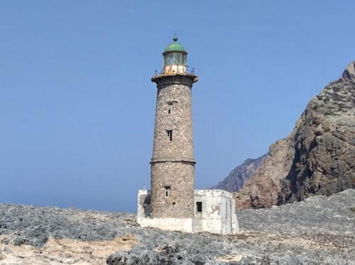
1901 (station established 1857). Active; focal plane 114 m (374 ft); three white flashes every 30 s. 25 m (82 ft) round masonry tower with lantern and gallery, rising from one end of a 1-story masonry keeper's house. Tower unpainted except for a white band around the base; lantern painted white with a green roof; keeper's house painted white. Efthymis Mitsos has a 2018 photo showing the white band painted around the base, Michalis Evangelidis has a 2019 photo, Trabas has Capt. Peter Mosselberger's photo, the Navy has a photo, Stephen Trifyllis has a distant photo in which the mainland can be seen in the distance, Marinas.com has aerial photos, Yannis Cotsonis has a 2019 street view, and Google has a satellite view. The site is accessible from the end of a road that approaches the cape. Located on Cape Spathi, the northern tip of Kythira. Site open, tower closed. . ARLHS GRE-120; Admiralty N4066; NGA 15048.
Kapsali Light
Kapsali Light, Kythira, June 2012
ex-Flickr Creative Commons photo by BeeFortyTwo
 

Peloponnese Region Lighthouses

Corinthia (Korinthía) District Lighthouses
Corinthia is the northeasternmost district of the Peloponnese region. It includes the Isthmus of Corinth, the narrow connection between the Peloponnese Peninsula and the rest of mainland Greece. Thus it has two coasts, one facing east on the Saronic Gulf of the Aegean Sea and one facing north on the Gulf of Corinth of the Ionian Sea.
* Likoporia
Date unknown. Active; focal plane 17 m (56 ft); two white flashes every 16 s. 15 m (49 ft) square pyramidal iron skeletal tower, painted white. Trabas has Eckhard Meyer's photo, a 2022 photo is available, and Google has a street view and a satellite view. Located on a point of land on the south side of the Gulf of Corinth directly opposite the Psaromyta lighthouse and about 2 km (1.25 mi) west of the village of Likoporia. Site open, tower closed. Admiralty N3967; NGA 14868.
* Melagavi (Melangavi, Cape Ireon, Loutraki)
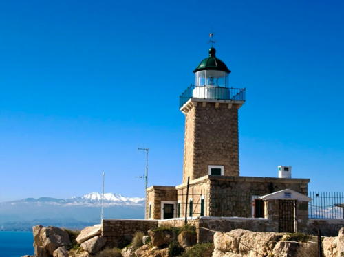
1897. Active; focal plane 58 m (190 ft); white flash every 10 s. 13 m (43 ft) square cylindrical stone tower with lantern and gallery, rising from the seaward end of a 1-story stone keeper's house. The lighthouse is unpainted stone with white trim; lantern painted white with a green roof. A photo is at right, Trabas has Philippe Le Bret's photo, Hercules Kladis has a 2022 photo, the Navy has a good photo, Yaroslav Tkachev has a street view, and Google has a satellite view. Cape Ireon projects westward into the Gulf of Corinth and shelters the bay leading to the city of Kórinthos (Corinth). Located on the point of the cape about 15 km (9 mi) west of Loutraki. Accessible by road. Site open, tower closed. . ARLHS GRE-018; Admiralty N3972; NGA 14844.
* Sousaki (Susaki)
1894. Active; focal plane 10 m (33 ft); green flash every 10 s. 7.5 m (25 ft) round cylindrical rubblestone tower with lantern and gallery, attached to a 1-story rubblestone keeper's house. Lighthouse unpainted; lantern dome painted green. Trabas has a good closeup, Rolandos Nini has a 2021 photo, Angelos Spanakos has a 2018 photo, the Navy has a closeup photo, and Google has a satellite view. This lighthouse was built to guide westbound ships approaching the Corinth Canal, which connects the Saronic Gulf to the Gulf of Corinth (the canal is too narrow for modern ships). Located on the Saronic Gulf on a point of land about 4 km (2.5 mi) east of Isthmia, the eastern entrance to the canal. Accessible by road. Site open, tower closed. . ARLHS GRE-136; Admiralty N4162; NGA 15320.

Melagavi Light, Loutraki, February 2011
unattributed Google Maps photo
 

Arcadia District Lighthouse
Arcadia is the district in the central part of the Peloponnese region, but it also includes a portion of the east coast of the peninsula facing the Argolic Gulf. This coastal area is called Kynouria (or Cynuria).
* Astros (Ákra Astros) (1)
1893. Inactive. 7 m (23 ft) square cylindrical rubblestone tower with lantern and gallery, attached to the seaward side of a small square 1-story keeper's house. The lighthouse is unpainted; lantern painted white with a blue dome. Trabas has a closeup photo, a 2021 photo is available, and Google has a satellite view and a closeup street view. The active light (focal plane 77 m (253 ft); white flash every 5 s) has been moved to a small skeletal tower on heights of the cape about 900 m (0.56 mi) to the north; Google has a satellite view. Located on a promontory on the east side of the harbor of Astros, a port on the west side of the Argolikos Kolpos (Argolic Gulf). Site open, tower closed. ARLHS GRE-045; New light: Admiralty N4104, NGA 15124.

Laconia District Lighthouses
The southernmost district of Peloponnese, Laconia includes two long peninsulas ending in Capes Tenaro and Maleas, respectively, and separated by the broad Gulf of Laconia.

*
Monemvasia (1)
1896 (rebuilt 2015). Reactivated (focal plane about 20 m (66 ft); white flash every 5 s). Approx. 10 m (33 ft) square stone tower with lantern and gallery attached to a 1-story stone keeper's house. The Navy's photo is at right, Trabas has Eckhard Meyer's closeup photo, Kostas Tsitlakidis has a 2017 photo, Manolis Akoumianakis has a 2018 photo, and Google has a satellite view. For many years the active light (focal plane 15 m (49 ft)) was on a 7 m (23 ft) square skeletal tower; the historic lighthouse was unroofed and in ruins. Mark Hensley has a 2006 photo of the lighthouse in ruins. The lighthouse was rebuilt in 2015 by a government program called the National Strategic Reference Framework. Lighthouse, fortress, and the tiny village of Monemvasia are located on a high, rocky island about 32 km (20 mi) north of Cape Maleas. Accessible by road, since the island is connected to the mainland town of Gefyra by a causeway. Site open, tower closed. . ARLHS GRE-098; Admiralty N4080; NGA 15092.

Monemvasia Light, Monemvasia
Hellenic Navy photo
Maleas (Ákra Maleas, Cape Malea)
1883. Active; focal plane 40 m (131 ft); white flash every 10 s. 15 m (49 ft) square cylindrical stone tower with lantern and gallery, rising from a small 1-story masonry keeper's house. The lighthouse is unpainted; lantern painted white with a green dome. Trabas has Capt. Peter Mosselberger's photo, Chrysovalántis Karantzís has a photo, a 2017 photo and a 2021 photo are available, and Google has a satellite view. Cape Maleas is the southeastern tip of the Peleponnisos. Located at the easternmost point of the cape, about 1.5 km (1 mi) north of the southernmost point. Perched on a very steep slope, the lighthouse is very difficult to access. Site and tower closed. ARLHS GRE-093; Admiralty N4078; NGA 15044.
Zovollo (Ákra Zóvollo)
Date unknown. Active; focal plane 13 m (43 ft); white flash every 7 s. 4 m (13 ft) round lantern mounted on a square masonry base. Lantern painted white. Trabas has a closeup photo and Google has a satellite view. Located on a promontory about 7 km (4.5 mi) west of Cape Maleas, near the southeastern tip of the Peleponnisos. Site open, tower closed. ARLHS GRE-182; Admiralty N4076; NGA 15040.
Kranai (Gythio, Gytheio)
1873. Active; focal plane 23 m (75 ft); three white flashes every 18 s. 23 m (75 ft) octagonal stone tower with lantern and gallery, attached to the seaward side of a 1-story stone keeper's house. The lighthouse is unpained white stone; lantern painted white with a green roof. A photo by Harris Skordakis is at right, Trabas has Eckhard Meyer's closeup photo, Vasilis Poul has a good photo, Lighthouse Digest has a closeup photo by Mike Rice, the Navy has an excellent photo, Nickolas Lerounis has a street view, and Google has a satellite view and a distant street view from the Gytheio waterfront. Gytheio is a historic seaport on the west side of the Lakoniakos Kolpós (Gulf of Lakonia), and Kranai (Cranae) is a small island on the south side of Gytheio harbor, connected to the mainland by a causeway. The name is derived from kranos (helmet) because according to ancient legend the warrior Paris left his helmet here after spending his first night with Helen of Troy on the island. This handsome lighthouse is built of marble quarried on the Tenaro peninsula within a few miles of the tower. Savas says that the light station was donated to the Hellenic Maritime Museum in 1989 but apparently it has never been open to the public; a visitor in 2013 found it gated with a no-trespassing sign. Located at the eastern tip of the island of Kranai. Site and tower closed. . ARLHS GRE-073; Admiralty N4052; NGA 15008.

Kranai Light, Gytheio, August 2022
Instagarm photo by Harris Skordakis
* Ákra Taínaro (Cape Tenaro, Cape Matapan)
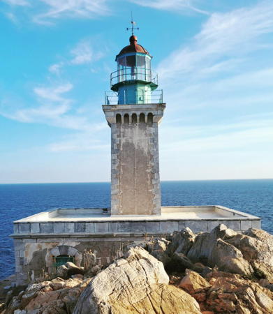
1882. Active; focal plane 41 m (135 ft); two white flashes every 20 s. 16 m (52 ft) square cylindrical stone tower with lantern and gallery, centered on a 1-story stone keeper's house. The lighthouse is unpainted; lantern painted white with a gray metallic roof. Eleanna Martinou's 2023 photo is at right, Trabas has Capt. Peter Mosselberger's photo, a good 2006 photo is available, Marinas.com has aerial photos, Mathieu Capronnier has a street view, and Google has a good satellite view. Ákra Taínaro (Cape Matapan) is the southernmost point of the Greek mainland. Located on the point of the cape, about 10 km (6 mi) south of Vatheia. Accessible by road and a short hike. Site open, tower closed. . ARLHS GRE-125; Admiralty N4048; NGA 14992.
* Liméni
1898. Active; focal plane 14 m (46 ft); quick white flash every 1.5 s. 6 m (20 ft) skeletal post light atop a small 1-story stone keeper's cottage. Light tower painted white; keeper's house unpainted. Trabas has Eckhard Meyer's photo and Google has a satellite view of the station. Located at the south entrance to the harbor of Liméni, on the east side of the Messiniakos Kolpós (Gulf of Messinia), about 3 km (2 mi) northwest of Areopoli. Accessible by road. Site open, tower closed. ARLHS GRE-091; Admiralty N4040; NGA 14980.

Messenia (Messinia) District Lighthouses
Messenia is the district of the Peloponnese region located at the southwestern corner of the Greek mainland. The county surrounds the Messenian Gulf.

*
Kitries
1892. Active; focal plane 32 m (105 ft); two white flashes every 12 s. 11 m (36 ft) square stone tower with lantern and gallery, rising from a 1-story stone keeper's house. The lighthouse is unpainted; lantern painted white. A 2010 photo and a 2020 view from the sea are available, Trabas has a photo taken from the heights above the lighthouse, Volodymyr Shcherbenko has a 2023 photo, Marinas.com has aerial photos, and Google has a satellite view. The lighthouse guides vessels approaching the port of Kalamata. Located on Ákra Kitries, a prominent cape on the east side of the Messiniakos Kólpos (Gulf of Messenia), about 3 km (2 mi) southwest of the village of Kitries. The coastline is fairly rugged in this area, but the lighthouse is apparently accessible by hiking trail. Site open, tower closed. ARLHS GRE-082; Admiralty N4032; NGA 14968.

Ákra Taínaro (Cape Matapan) Light, Vatheia, September 2023
Instagram photo by Eleanna Martinou
Sapienza (Sapiéntza)
1885. Active; focal plane 116 m (381 ft); three white flashes every 20 s. 9.5 m (31 ft) octagonal stone tower with lantern and gallery, attached to the seaward side of a 1-story rubblestone keeper's house. The lighthouse is unpainted stone; lantern painted white with a black dome. Dim Skourt has a 2021 photo, Piet de Nijs has a 2017 photo, Panagiotis Tokmakidis has a 2022 photo, the Navy has a closeup photo, Trabas has Eckhard Meyer's distant photo, and Google has a good satellite view. Sapienza is an island about 6 km (3.5 mi) in length located off Methoni at the southwestern corner of the Peloponnese. Most of the island is set aside as a nature reserve, but it is rarely visited. Located on a high promontory at the south end of the island. Accessible only by boat. Site open, tower closed. ARLHS GRE-116; Admiralty N4016; NGA 14932.
Sfaktiria (Pylos, Pílos) (3)
Date unknown (station established 1873). Active; focal plane 36 m (118 ft); two white flashes every 10 s. Approx. 9 m (30 ft) square pyramidal skeletal tower with gallery, painted white, standing in front of the original lighthouse, a square cylindrical stone tower attached to the seaward end of a 1-story stone keeper's house. Sava's photo shows the second light on a 3 m (10 ft) square stone pillar. Trabas has a photo of the current light in which the old lighthouse and the stone pillar are also seen. Google has a satellite view. The historic lighthouse is abandoned and falling into ruin. Located on a small island at the west side of the entrance to the bay of Pylos. Accessible only by boat. Site open, tower closed. ARLHS GRE-185; Admiralty N4008; NGA 14908.

Lighthouses of Southern West Greece

Ilia (Elis) District Lighthouses
Ilia, also called Elis, is a district of the West Greece region occupying the northwestern part of the Peloponnese Peninsula.

Katákolon
1865. Active; focal plane 49 m (161 ft); white flash every 4 s. 9 m (30 ft) octagonal cylindrical stone tower rising from the seaward side of a 1-story stone keeper's house. The lighthouse is unpainted stone; lantern painted white with a green roof; keeper's house painted white. A 2022 photo by Stavros Mouzakis is at right, Trabas has an excellent closeup photo, the Navy has a closeup photo, Athanasios Nikolakopoulos has a photo, Amadeus Stergiou has a 2019 photo, Olga Karali has a 2022 photo, and Google has a satellite view. Located at the end of Ákra Katákolon, a sharp promontory about 15 km (9 mi) west of Pirgos. The lighthouse is accessible by road, but judging from the scarcity of photos the area may be restricted. Site status unknown. ARLHS GRE-080; Admiralty N3998; NGA 14892.
Kafkalída (Cape Killini)
1906. Active; focal plane 21 m (69 ft); white or red light, depending on direction, 2 s on, 8 s off. 15 m (49 ft) square stone tower with gallery, attached to a 1-story stone keeper's house. Lantern removed. The lighthouse is unpainted gray stone with white stone trim; the original lantern has been removed and replaced by a small lantern painted white. Trabas has Eckhard Meyer's photo, a 2015 closeup photo is available, the Navy also has a closeup photo, Marinas.com has aerial photos, and Google has a satellite view. Kafkalída is a small island off Cape Kyllíni (Killini) at the northwestern corner of the Peloponnisos. Located at the highest point of the island. Accessible only by boat; transportation can be hired in Kyllini. Site open, tower closed. ARLHS GRE-074; Admiralty N3996; NGA 14880.

Katákolon Light, Pirgos, August 2022
Instagram photoby Stavros Mouzakis

Achaea District Lighthouses
Achaea is a district of the West Greece region, located in the northern Peloponnese Peninsula and facing the Gulfs of Corinth and Patras.

*
Patras (replica)
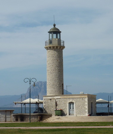
1999 replica of 1880 lighthouse. Active (unofficial); focal plane about 17 m (56 ft); continuous (?) white light. Approx. 13 m (43 ft) round cylindrical stone tower with lantern and gallery, rising from a 1-story stone keeper's house. A photo is at right, Adam Balch has a photo, another good photo is available, Athanasios Panagopoulos has a 2021 photo, Wikimedia has additional photos, and Google has a street view and a satellite view. Klaus Huelse has a postcard view of the original lighthouse, which was located at the end of a pier at the foot of Agios Nikolaos street in Patras. The lighthouse was demolished in 1972, a tragic loss of a valuable and valued civic landmark. Located on the waterfront at the west end of the harbor of Patras. Site open. tower status unknown. . ex-Admiralty E3920.
* Drepano (Drepanon, Rio, Rion, Morea)
1880. Active; focal plane 9 m (30 ft); white flash every 10 s. 7 m (23 ft) round rubblestone tower with lantern and gallery, attached to the seaward side of a 1-story keeper's house. 4th order (?) Fresnel lens in use. The tower is unpainted white stone; lantern and keeper's house painted white; lantern roof is black. Trabas has an excellent photo, Andreas Stamatopoulos has a closeup photo, Georgios Tsionis has a 2021 photo, Marinas.com has aerial photos, Marita Kaloglou has a street view, and Google has a satellite view. Located on a point of land at the base of a sandy spit about 8 km (5 mi) northeast of the Rion-Antirion Bridge. Site open, tower closed. . ARLHS GRE-061; Admiralty N3948; NGA 14876.

Information available on lost lighthouses:

Notable faux lighthouses:

Faros Patras
Patras Light replica, Patras, October 2010
Wikimedia public domain photo by Xocolatl

Adjoining pages: North: Northern Greece | East: Aegean Islands | Southeast: Crete | West: Ionian Islands

Return to the Lighthouse Directory index | Ratings key

Posted November 27, 2006. Checked and revised October 30, 2023. Lighthouses: 39. Site copyright 2023 Russ Rowlett and the University of North Carolina at Chapel Hill.