Lighthouses of Hungary

Hungary, known as Magyarország ("Magyar Country") in its own langauge, is a Central European country located in the Danube River Basin. The Danube is a busy waterway that flows southward through the center of the country, but there are presently no lighthouses on the river in Hungary.

After centuries as an independent kingdom Hungary was on the frontline of the struggle between Europe and the Ottoman (Turkish) Empire in the 16th and 17th centuries. Through the 19th century and until World War I Hungary shared its monarch with Austria, creating the Austrian and later Austro-Hungarian Empire. With the collapse of that empire Hungary resumed its independence following the war.

Lake Balaton, the largest lake of Central Europe, is located in the western part of Hungary. The lake is 78 km (48 mi) long and up to 14 km (8.7 mi) wide. It is a very popular recreational area and there are at least three dozen marinas around the shores of the lake. Many of the marinas have pierhead lights that are tall, robust masts, often as much as 15 m (49 ft) in height. As a general rule the Directory does not list mast lights, but this page describes a selection of them, including some of the taller lights most easily accessible on public piers.

Locks on the River Sió, the lake's outlet, allow small craft to access the lake from the Danube.

The Hungarian word for a lighthouse is világítótorony ("light tower"). is a lake, folyó is a river, móló is a pier, and kikötő is a harbor.

General Sources
World of Lighthouses - Hungary
Photos by various photographers available from Lightphotos.net
Lighthouses in Hungary
Photos by various photographers available from Wikimedia.
Leuchttürme in Ungarn
Photos by Andreas Köhler.
Lighthouses of the Danube
This January 2013 blog by Dániel Szávoszt-Vass has good information and photos on Danube lighthouses.
Seezeichen der Alpenregion auf historischen Postkarten
Historic postcard views posted by Klaus Huelse. Hungarian lighthouses are at the bottom of the page.
Navionics Charts
Navigation chart for Lake Balaton.


Balatonfüred Light, Balatonfüred, February 2020
Google Maps photo by Szatmári Ádám


Somoga County (South Coast) Lightbeacons
* [Balatonboglár]
Date unknown. Active; focal plane about 13 m (43 ft); red light, pattern unknown. 12 m (39 ft) square skeletal mast painted with red and white horizontal bands. Lightphotos.net has Köhler's photo, Zsolt Szentpéteri has a 2020 photo, László Rázga has a street view, and Google has a distant satellite view of the mole.
* [Siófok West Pier]
Date unknown. Active; focal plane about 15 m (49 ft); green light, pattern unknown. 12 m (39 ft) mast, lower half solid and upper half skeletal, painted with green and white horizontal bands. Alberto Cobretti has a street view and Google has a satellite view. Siófok is the largest town on the lake and the location of the lake's outflow through the Sió River. The river is now canalised as the Sió Channel (Sió-csatorna) leading from the lake to the Danube River 121 km (75 mi) to the southeast. Located on the west breakwter at Siófok. Site open, tower closed.
* Siófok East Pier
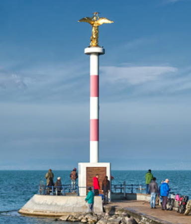
Date unknown. Active; focal plane 12 m (39 ft); red (?) light, pattern unknown. 10 m (33 ft) round post centered on a 1-story building and crowned by a gold statue of "The Benevolent Angel of Peace." Post painted with red and white horizontal bands. Sinka Pál's photo is at right, Lightphotos.net has Köhler's photo, Wikimedia has photos, and Google has a street view and satellite view. Köhler has a photo of the tower displaying a white light. Located on the east breakwter at Siófok. Site open, tower closed.

Veszprém County (North Coast) Lightbeacons
* [Balatonkenese East Pier]
Date unknown. Active; focal plane about 13 m (43 ft); green light, pattern unknown. 11 m (36 ft) square metal mast painted with green and white horizontal bands. Szatmári Ádám has a good street view, Bálint Már has a closeup street view, and Google has a distant satellite view. Balatonkenese is a town at the extreme northeast end of the lake. Located on the short east pier of the town's large marina. Site open, tower closed.
* [Balatonkenese West Pier]
Date unknown. Active; focal plane about 13 m (43 ft); red light, pattern unknown. 11 m (36 ft) square metal mast painted with red and white horizontal bands. Nezz Korbe has a closeup street view and Google has a distant satellite view. Located on the long outer breakwater of the marina. Site open, tower closed.


East Pier Light, Siófok, November 2019
Google Maps photo by Sinka Pál

* [Balatonfüred]
Date unknown. Active; focal plane about 13 m (43 ft); white light, pattern unknown. 12 m (39 ft) square metal mast painted with red and green horizontal bands. Szatmári Ádám has a closeup street view, (also seen at the top of this page), Lightphotos.net has a photo, and Google has a fuzzy satellite view. Balatonfüred is a town of about 13,000 residents on the central north coast of the lake; it serves a center for resorts on that coast. The light is at the east corner of a broad pier that features a restaurant. Site open, tower closed.
* [Tihanyi East Pier]
Date unknown. Active; focal plane about 11 m (36 ft); green light, pattern unknown. 10 m (33 ft) square metal mast painted with green and white horizontal bands. Balazs Lorincz has a closeup street view, Lightphotos.net has Köhler's photo, and Google has a distant satellite view. Ferries cross the narrowest passage of the lake from Tihanyi to Szántód on the south coast. Located on the east side of the entrance to the ferry harbor. Site open, tower closed.
* [Tihanyi West Pier]
Date unknown. Active; focal plane about 11 m (36 ft); red light, pattern unknown. 10 m (33 ft) square metal mast painted with red and white horizontal bands. István Dalmadi has a closeup street view, Lightphotos.net has Köhler's photo, and Google has a distant satellite view. Site open, tower closed.
* [Badacsony East Pier]
Date unknown. Active; focal plane about 11 m (36 ft); green light, pattern unknown. 10 m (33 ft) square metal mast painted with green and white horizontal bands. József Bózsa's photo is at right, Csaba Laszkovszky has a closeup street view, and Google has a distant satellite view. Located on the east pier at the marina entrance in Badacsony, a resort town on the northwest coast of the lake. Site open, tower closed.


East Pier Light, Badacsony, July 2007
ex-Panoramio photo copyright József Bózsa; permission requested


Zala County (West Coast) Lightbeacon
* [Keszthely Móló]
Date unknown. Active; focal plane about 17 m (56 ft); green light, pattern unknown. 15 m (49 ft) square metal mast painted with green and red horizontal bands. Mateusz Sołtys has a 2023 photo, Köhler has a photo, and Google has street view and an indistinct satellite view. Keszthely is a city of about 25,000 residents at the west end of the lake. The pier is a popular attraction with a café and a terminal for boat tours of the lake. Located at the end of the pier. Site open, tower closed.

Information available on lost lighthouses:

  • Petőfi Bridge, Budapest (1937-1945). Szávoszt-Vass discusses this lighthouse, built to honor sailors of the former Imperial (Austro-Hungarian) Navy. Retreating German troops blew up the bridge and lighthouse in January 1945. The bridge was rebuilt, but not the lighthouse.

Notable faux lighthouses:

Adjoining pages: East: Austria | Southeast: Serbia

Return to the Lighthouse Directory index | Ratings key

Created August 29, 2021. Checked and revised September 19, 2023. Lighthouses 1. Site copyright 2023 Russ Rowlett and the University of North Carolina at Chapel Hill.