Lighthouses of Indonesia: Western Aceh, Sumatra

Indonesia is a huge country of Southeast Asia, stretching along both sides of the Equator for more than 46 degrees of longitude (roughly 5100 km or 3200 miles). It occupies 17,504 islands, by official count, including more than 6000 inhabited islands. It is the world's fourth most populous nation with a population currently estinated ay about 280 million. More than half of the population lives on the island of Java. Other major islands include Sumatra in the west, Borneo (shared with Malaysia and Brunei) in the northwest, Sulawesi in the northeast, and the eastern half of New Guinea in the far east. Other well known islands include Bali, Lombok, Sumbawa, Flores, and Timor (shared with independent East Timor) along the south side of the country.

The unification of the country was accomplished over many years of struggle by Dutch colonial authorities. The Dutch East India Company was founded in 1602 to establish and extend Dutch administration, and after the company folded the Netherlands established the Dutch East Indies colony and gradually extended its boundaries to reach the present boundaries of Indonesia. During World War II Japan occupied the islands from March 1942 to the end of the war in 1945. The Republic of Indonesia proclaimed its independence immediately after the war ended and following some conflict the Netherlands accepted the country's independnece in 1949.

Sumatra (Sumatera in Indonesian) is the world's sixth largest island and the westernmost of the major islands of Indonesia. It is separated from Malaysia to the north by the Malacca Strait, from Kalimantan (Borneo) to the northeast by the broad Karimata Strait, and from Java to the southeast by the Sunda Strait. Its south coast faces the open Indian Ocean. The population of Sumatra is about 60 million.

Located at the northwestern end of Sumatra, Aceh (pronounced AH-chay in English) was a powerful independent sultanate for more than three centuries before bring brought, more or less, under Dutch control in the early 20th century. It has been the scene of a lengthy and sometimes violent separatist movement, first against Dutch control and then against Indonesian administration. Following the disastrous tsunami of 26 December 2004 a peace agreement was negotiated with the help of Finnish diplomats and signed in August 2005.

Indonesia is divided into 38 provinces (provinsi) and the provinces are subdivided into county units called regencies (kabupaten). Aceh is a province of Indonesia but under the 2005 peace agreement it is governed as a special territory (daerah istimewa) enjoying a considerable degree of autonomy. The capital is Banda Aceh and the territory has a population of roughly four million. This page includes lighthouses of the western half of Aceh, the section facing the open Indian Ocean. There's another page for Eastern Aceh.

More than 700 languages are spoken in Indonesia. The official national language, Indonesian (Bahasa Indonesia), was standardized from a form of Malay that served as a lingua franca across the archipelago. In Indonesian a lighthouse is a mercusuar or a menara suar. Tanjung is a cape, ujung is a headland or point of land, bukit is a hill, sungai is a river, kuala or muara is an estuary or river mouth, pulau is an island, karang is a reef, batu is a rock, laut is a sea, selat is a strait, teluk is a bay, pelabuhan is a harbor, and labuhan is a port.

Aids to navigation in Indonesia are operated and maintained by the Directorate of Marine Navigation (Direktorat Navigasi Laut) within the Directorate General of Sea Transportation.

ARLHS numbers are from the ARLHS World List of Lights. Admiralty numbers are from volume F of the Admiralty List of Lights & Fog Signals. U.S. NGA List numbers are from Publication 112.

General Sources
Lighthouses in Indonesia
Photos by various photographers available from Wikimedia; most of the photos are historic.
World of Lighthouses - Indonesia
Photos by various photographers available from Lightphotos.net.
Online List of Lights - Indonesia
Photos by various photographers posted by Alexander Trabas.
GPSNavigationCharts
Navigation chart information for Aceh.
Navionics Charts
Navigation chart for Aceh.

Breueh Light, Aceh Besar, January 2020
Google Maps photo by Syahwal Fazillah

West Coast (Indian Ocean) Lighthouses

Aceh Singkil Regency: Singkil Lighthouses
* Singkil (Singkel) Front
1912 (?). Active (?); focal plane about 20 m (66 ft); white light, pattern unknown. Approx. 17 m (56 ft) square skeletal tower. Musliono Adicipta has a 2015 photo, Khairul Fajri has a 2022 view from the pier, a distant street view is available, and Bing has a satellite view. The relationship of the two Singkel lights is not clear; Navionics charts both as active, in which case they may function as a range although they are not listed in that role. The regency capital of Singkil, a town of about 15,000 residents, is an important ferry terminal with departures to the large islands of Simeulue and Nias as well as the nearby Banyak Islands. Located at the base of the pier at Singkel in the extreme southern end of Aceh. Site open, tower closed. Not listed by the Admiralty.
* Singkil (Singkel) Rear
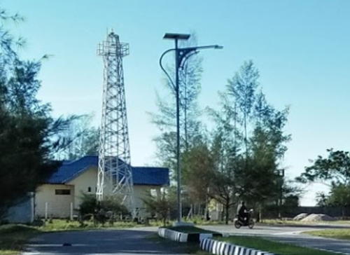
Date unknown (station established 1912). Active; focal plane 33 m (108 ft); white flash every 6 s. 30 m (98 ft) skeletal tower, painted white. Delimawati Zalukhu has a distant photo (a portion is at right), Musliono Adicipta's photo shows most of the tower, and Google has a satellite view. A 1917 coast pilot lists the original light with a focal plane of 21 m (69 ft). Located about 200 m (220 yd) north of the previous light. Site open, tower closed. ARLHS IDO-279; Admiralty F1267; NGA 23292.
* Singkil (Singkel) Wharf
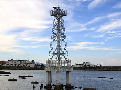
Around 2014. Active; focal plane about 12 m (39 ft); white flash every 3 s. 10 m (33 ft) round barbell-shaped white tower. Sahidin Pandapotan Lubis has a 2016 photo, a closeup is available, and Bing has an indistinct satellite view. Located at the commerical pier of Singkil about 1 km (0.6 mi) west of the ferry pier. Site open, tower closed. Admiralty F1269.7.
Karang Rumambi
Date unknown. Active; focal plane 14 m (46 ft); two red flashes every 10 s. 14 m (46 ft) square pyramidal skeletal tower, painted white and mounted on a square platform supported by piles. No photo available but Google has a satellite view. Located at the end of a shoal about 8 km (5 mi) southwest of Singkel. Accessible only by boat. Site status unknown. Admiralty F1267.5; NGA 23291.

Singkil (Rear) Light, Singkil, July 2017
Google Maps photo by Delimawati Zalukhu

Aceh Singkil Regency: Banyak Islands Lighthouses
Pulau Sarangalu (Sarang Uln)
Date unknown. Active; focal plane 41 m (135 ft); white flash every 5 s. 40 m (131 ft) tapered square skeletal tower painted white. Four 1-story coast guard station buildings. No photo available but Google has a good satellite view of the station. Located on a small island at the south end of the Banyak Islands, a group of islands between the mainland and the larger island of Simeulue, about 50 km (30 mi) west of Singkil. Accessible only by boat. Site status unknown. Admiralty F1273; NGA 23304.
Karang Panjang (2)
Around 2017. Active; focal plane 10 m (33 ft); three quick white flashes every 6 s. 10 m (33 ft) square pyramidal skeletal tower mounted on a square platform supported by piles. No photo available but Google has a satellite view. There is an older and smaller light to the southeast. Located on a shoal on the approach to Pulau Banyak. Accessible only by boat. Site open, tower closed. Admiralty F1270; NGA 23300.
Pulau Rangit Kecil
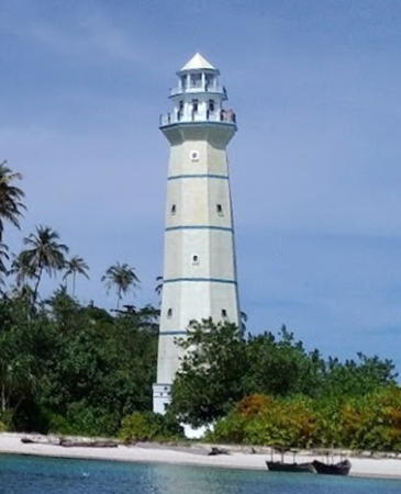
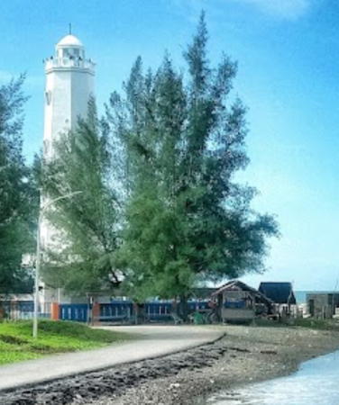
Around 2015. Active; focal plane 31 m (102 ft); white flash every 3 s. 30 m (98 ft) octagonal concrete tower with lantern and gallery painted a pale yellow. A 2016 photo is at right, Hari Faisal has a 2018 drone view and a more distant drone view is available, Martin Schätz has a 2022 photo, and Google has a satellite view. Located on a small island at the south end of the Panjang reef. Accessible only by boat. Site open, tower closed. Not yet listed by the Admiralty.
Pulau Panjang
Date unknown. Active; focal plane 31 m (102 ft); white flash every 3 s. 10 m (33 ft) concrete tower No photo available but Google has a satellite view. Located on the north point of Pulau Panjang marking the approach to Pulau Banyak from the southeast. Accessible only by boat. Site open, tower closed. Admiralty F1270.5; NGA 23298.
Pulau Bagu (2)
Date unknown. Active; focal plane 45 m (148 ft); four white flashes every 18 s. Approx. 40 m (131 ft) square skeletal tower with gallery, painted white. Rahmat Fadhli has a distant drone view (tower on the island at upper left) and Google has a satellite view. The earlier light here had a focal plane of 32 m (105 ft). Located on the north point of an island sheltering the harbor of Pulau Banyak. Accessible only by boat. Site status unknown. Admiralty F1271.5; NGA 23295.
Pulau Banyak (Pulau Baleh, Pulau Balai)
Date unknown. Active; focal plane 8 m (26 ft); white flash every 5 s. 7 m (23 ft) square white pyramidal skeletal tower. Hafiz Kurniawan has a 2017 photo, another photo is available, and Google has a distant satellite view. Located at the foot of the pier at Pulau Balai (Pulau Banyak), the principal settlement in the Banyak Islands. Site open, tower closed. Admiralty F1271; NGA 23296.

Pulau Rangit Kecil Light, Pulau Banyak, July 2016
Google Maps photo by L G

Simeulue Regency Lighthouses
Simeulue is a large island about 130 km (80 mi) off the coast of West Aceh. The island was near the epicenter of the great earthquake of 26 December 2004 and suffered another major earthquake several months later. The two earthquakes tilted the entire island, raising the west coast by about 2 meters and dropping the east coast a similar amount. The island has a population of about 95,000. Simeulue is accessible by air and the regency capital of Sinabang is accessible by ferries from Labuhan Haji and Singkil.

Pulau Babi
Date unknown. Active; focal plane 32 m (105 ft); white flash every 5 s. Approx. 27 m (89 ft) square skeletal tower, painted white. No photo available but Bing has a satellite view. Babi is a small island about 50 km (30 mi) southeast of Pulau Simeulue. Located on the west side of the island. Accessible only by boat. Site status unknown. Admiralty F1273.5; NGA 23305.
* Teluk Sinabang
2014. Active; focal plane 20 m (66 ft); white flash every 5 s. 18 m (59 ft) square cylindrical skeletal tower, painted white. Wan Zulkarnain Barus's photo is at right, Suhra Ilyas has an evening photo, Mohamad Nusur has a street view, and Google has an indistinct satellite view. Teluk Sinabang is a magnificent natural harbor on the southeastern coast of Simeulue. Located at the base of the main pier at Sinabang. Site open, tower closed. Admiralty F1273.7.
Pelabuhan Kargo Sinabang
Date unknown. Active (charted by Navionics); focal plane about 16 m (52 ft); white light, pattern unknown. Approx. 16 m (52 ft) square pyramidal skeletal tower. Nanang Soma has a photo, the light appears at the start of Motivasi Kehidupan's video of the harbor, Irfan Fauzi has a 2021 photo, and the top of the tower is surrounded by trees in Google's satellite view. Located at a commercial quay about 800 m (1/2 mi) south of the Teluk Sinabang light. Site status unknown. Not listed by the Admiralty.
* Pelabuhan Ferry Sinabang (Pelabuhan Kolok)
Date unknown. Active; focal plane about 22 m (72 ft); white light, pattern unknown. Approx. 20 m (66 ft) square white skeletal tower with gallery. Sumayyah M. Nuh has a 2020 photo, Yusrizal Siregar has a photo, and Google has satellite view. Located at a ferry terminal at the southern end of Teluk Sinabang, Site open, tower closed. Not listed by the Admiralty.
Pulau Panjang Kecil
Date unknown. Active; focal plane 16 m (52 ft); green flash every 3 s. 16 m (52 ft) tower on a platform supported by piles. No photo available but Google has a satellite view. Located just off the southeast end of an island marking the north side of the approach to Sinabang. Accessible only by boat. Site status unknown. Admiralty F1274; NGA 23316.
Ujung Babang
Date unknown (2008?). Active; focal plane 40 m (131 ft); white flash every 3 s. 25 m (82 ft) square cylindrical skeletal tower, painted white. No photo available but Google has a satellite view and the top of the tower appears at upper left in Nur Yadi's photo and video. Located on heights at the east side of the entrance to the harbor of Sinabang. Site status unknown. Admiralty F1274.5; NGA 23308.
Pulau Tepak (Pulau Tapah)
Date unknown. Active; focal plane 100 m (328 ft); white flash every 9 s. Approx. 30 m (98 ft) square skeletal tower painted white. No photo available but Google has a distant satellite view. This light has a range of 33 km (20 mi). Located on the summit of a high island off the southwest coast of Simeulue. Accessible only by boat. Site status unknown. Admiralty F1281; NGA 23306.

Teluk Sinabang Light, Simeulue, October 2017
Google Maps photo by Wan Zulkarnain Barus
Pulau Simeulue Cut
2006. Active; focal plane 90 m (295 ft); two white flashes every 12 s. Approx. 30 m (98 ft) square skeletal tower painted white. No photo available but Google has a satellite view. Listed by NGA as "Pulau Simeuloe," this light has a range of 33 km (20 mi). Located on the summit of an uninhabited high island off the central west coast of Simeulue. Accessible only by boat. Site status unknown. Admiralty F1280; NGA 23307.
Pulau Salaut Besar ("Big Salute Island")
Date unknown. Active; focal plane 44 m (144 ft); three white flashes every 20 s. Approx. 40 m (131 ft) square skeletal tower painted white and mounted atop a 2-story Coast Guard building. Busra Alfian has the 2020 photo at right and Google has a satellite view. This coast guard station has numerous buildings. Located on a small island about 40 km (25 mi) northwest of the northern tip of Simeulue. Accessible only by boat. Site status unknown. Admiralty F1279; NGA 23318.
Ujung Sibigo (Ujung Bikha)
Date unknown. Active; focal plane 14 m (46 ft); green flash every 5 s. 14 m (46 ft) square skeletal tower. No photo available but Google has an indistinct satellite view. Located on the north side of the entrance to Sibigo Bay, a large inlet on the northeast coast of Simeulue. Site status unknown. Admiralty F1278.5; NGA 23317.
Pulau Tinggi
Date unknown. Active; focal plane 40 m (131 ft); white flash every 3 s. 30 m (98 ft) skeletal tower, painted white. Four blue-roofed Coast Guard buildings. No photo available, but Google has a satellite view. The lighthouse guides vessels approaching Simeulue Barat (North Simeulue), a port on the northeast coast of Simeulue. Located on a small island about 4 km (2.5 mi) off the coast of Simeulue. Accessible only by boat. Site status unknown. ARLHS IDO-341; Admiralty F1278; NGA 23310.
Ujung Sirih
Date unknown. Active; focal plane 15 m (49 ft); red flash every 7 s. 15 m (49 ft) square skeletal tower painted red and mounted on a square platform supported by piles. No photo available but Bing has a satellite view. Located at the east side of the entrance to the bay of Lhok Dalam on the central east coast of Simeulue. Accessible only by boat. Site open, tower closed. Admiralty F1277; NGA 23310.5.
Pulau Siumat
Date unknown. Active; focal plane 42 m (138 ft); white flash every 6 s. Approx. 25 m (82 ft) square cylindrical skeletal tower, painted white. No photo available but Bing has a distant satellite view. Siumat is a small island about 16 km (10 mi) off the central east coast of Simeulue. Located at the east end of the island. Site status unknown. Accessible only by boat. Admiralty F1276; NGA 23311.

Pulau Salaut Besar Light, Simeulue, June 2020
Google Maps photo by Busra Alfian

Aceh Selatan (South Aceh) Regency Lighthouses
Pulau Trumon
Date unknown. Active; focal plane 10 m (33 ft); white flash every 5 s. 10 m (33 ft) square pyramidal skeletal tower mounted on a square platform supported by piles. No photo available but Bing has a fuzzy satellite view. Located on a shoal on the approach to Trumon. Accessible only by boat. Site open, tower closed. Admiralty F1283.
* Tapaktuan Port
Date unknown. Active; focal plane 30 m (98 ft); white flash every 5 s. 20 m (66 ft) square skeletal tower with gallery painted white. Toyib Kusuma Jaya has a 2018 photo, Wahyu Khz has a photo, another photo is available, and Bing has an indistinct satellite view. Located on the waterfront in Tapaktuan, the capital of South Aceh Regency. Site appears open, tower closed. Admiralty F1283.5.
Ujung Kupiah (Tapaktuan) (2?)
Date unknown. Active; focal plane 56 m (184 ft); white flash every 5 s. Approx. 25 m (82 ft) square cylindrical skeletal tower, painted white. Sandiri San has an aerial photo, Mu Zakir has a distant view from the port, and Bing has a satellite view. Located on a promontory on the southwest side of Tapaktuan. Site status unknown. Admiralty F1284; NGA 23320.
Labuhan Haji West
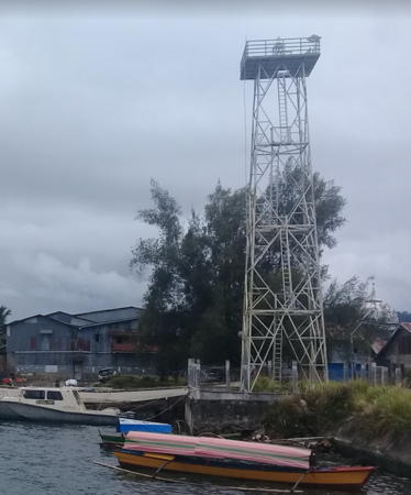
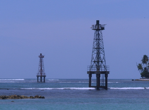
Date unknown. Active; focal plane about 14 m (46 ft); light characteristic unknown. Approx. 14 m (46 ft) square red skeletal tower with gallery. The light is on the left in the photo at right, Isnaidi Chanelaja has a 2018 photo of the two lights, a sunset photo is available, and Bing has a satellite view. Located at the edge of a dangerous reef about 300 m ().2 mi) southwest of the pier at Labuhan Haji, the most important terminal for ferries to Sinabang, Simeulue. Accessible only by boat, but easily seen from shore. Site open, tower closed. Not listed by the Admiralty or charted by Navionics.
Labuhan Haji East
Date unknown. Active; focal plane about 20 m (66 ft); light characteristic unknown. Approx. 20 m (66 ft) square skeletal tower with gallery. The light is on the right in the photo at right, Isnaidi Chanelaja has a 2018 photo of the two lights, a sunset photo is available, and Bing has a satellite view. Located beside the south breakwater at Labuhan Haji. Accessible only by boat, but easily seen from shore. Site open, tower closed. Not listed by the Admiralty or charted by Navionics.

Labuhon Haji West (left) and East Lights, South Aceh, March 2010
Aceh Department of Marine and Fisheries photo
* Pelabuhan Labuhan Haji
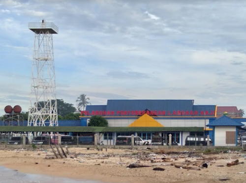
Date unknown. Active; focal plane about 20 m (66 ft); white light, pattern unknown. Approx. 20 m (66 ft) square skeletal tower with gallery. A photo is at right, Zahirin Eliyani has a photo, and Bing has a satellite view. Site open, tower closed. Not listed by the Admiralty or charted by Navionics.

Aceh Barat Daya (Southwest Aceh) Regency Lighthouses
Susoh (Ujung Seurangga) (2)
2017. Active; focal plane 10 m (33 ft); green flash every 5 s. Approx. 14 m (46 ft) square skeletal tower on a square platform supported by piles. This light replaced a 10 m (33 ft) round green barbell-shaped tower mounted on a square platform supported by piles. A 2020 view shows the new light and the empty platform of the earlier light, Sarjanuddin Jusuf has a photo of the first light, and Rita Suriyanti has a 2017 photo showing both lights. Bing has a satellite view. Located off a sand spit at Susoh. Site open, tower closed. Admiralty F1290; NGA 23324.
* Teluk Susoh (2)
Around 2013. Active; focal plane about 22 m (72 ft); white flash every 3 s. Approx. 20 m (66 ft) square skeletal tower, painted white. Ganang Ramadhan has a photo, another photo is available, Google has a street view from the nearby pier and Bing has a satellite view. This light replaced a 7 m (23 ft) square skeletal tower located on the other side of the pier; Sarjanuddin Jusuf has a 2008 photo of that light. Located just south of the pier at Susoh. Site open, tower closed. Admiralty F1291; NGA 23322.
* Susoh Range Rear
Date unknown. Active; focal plane about 20 m (66 ft); continuous white light. Approx 12 m (39 ft) tower. No photo available but Bing has an indistinct satellite view. The front light is apparently mounted on a warehouse. Located at a street intersection in the Pulau Kayu neighborhood northwest of the port area in Susoh. Site open, tower closed. Admiralty F1291.17.

Labuhon Haji Light, South Aceh, July 2018
Google Maps photo by Mulianto S

Nagan Raya Regency Lighthouse
Ujung Raya (Ujung Raja)
Date unknown. Active; focal plane 42 m (138 ft); four white flashes every 20 s. 40 m (131 ft) square skeletal tower, painted white. No photo available but Google has a satellite view. Located on a remote, rounded headland in Nagan Raya regency. Site status unknown. Admiralty F1289; NGA 23326.

Aceh Barat (West Aceh) Regency Lighthouses
Kuala Pesisir
Date unknown. Active; focal plane about 18 m (59 ft); white light, pattern unknown. Approx. 16 m (52 ft) tower. No photo available but Google has a distant satellite view. Located at a power plant about 8 km (5 mi) east of Muelaboh. Site and tower closed. Admiralty F1291.5.
* Teluk Muelaboh
2014. Active; focal plane 30 m (98 ft); white flash every 3 s. 26 m (85 ft) square skeletal tower painted white. The lighthouse is on the left edge of Aulian Syah's photo, Sayid G. Al Farisi has the view from the harbor, and Google has an indistinct satellite view. Located at the base of a pier at Muelaboh, the capital of West Aceh Regency. Site open, tower closed. Admiralty F1291.7.
* Ujung Kareueng (3?)
2023. Active; focal plane 27 m (89 ft); white light, 2 s on, 6 s off. 25 m (82 ft) square skeletal tower with gallery, painted white. Johan Nababan has the photo seen at right and Google has a satellite view. Wan Zulkarnain Barus has a 2017 photo of the previous light, Zul Irfan Ivan Gondrong has a view from the sea, another photo is available, Bing has a satellite view, and Google has a distant street view. This area was devastated by the 2004 tsunami and the original lighthouse must have been destroyed. Located on a promontory at Muelaboh. Site status unknown but probably open, tower closed. ARLHS IDO-350; Admiralty F1292; NGA 23328.
* Kuala Bubon (Lhok Bubon)
Date unknown. Active; focal plane about 20 m (66 ft); white light, pattern unknown. Approx. 16 m (52 ft) square white skeletal tower. A photo is available and Google has a satellite view. Located at the Lhok Bubon ferry terminal about 12 km (7.5 mi) northwest of Muelaboh. Site open, tower closed. Admiralty F1292.1.

Aceh Jaya Regency Lighthouses
Krueng Teunom
Date unknown. Active; focal plane 34 m (111 ft); red flash every 7.5 s. 30 m (98 ft) skeletal tower, painted white. No photo available but Google has a satellite view. Located at the Teunom River entrance northwest of Suak Uleue and about 50 km (30 mi) northwest of Muelaboh. (The river entrance is blocked by a bar, so this must be a coastal light rather than a harbor light.) Site status unknown. ARLHS IDO-149; Admiralty F1292.2; NGA 23328.5.
Ujung Baro
Date unknown. Active; focal plane 60 m (197 ft); two white flashes every 10 s. 30 m (98 ft) square skeletal tower, painted white. No photo available but Bing has a satellite view (with two superimposed images?). Udin Nandcungil has a photo taken atop the tower. Located on a tombolo (tied island) just off a promontory near Alue Titi. Site status unknown. ARLHS IDO-347; Admiralty F1292.35; NGA 23329.5.

Ujung Kareueng Light, Muelaboh, July 2023
Google Maps photo by Johan Nababan
Pulau Rangas
Date unknown. Active; focal plane 50 m (164 ft); white flash every 5 s. Approx. 30 m (98 ft) square white skeletal tower. No photo available but Google has a satellite view. Located on a small island about 3 km (1.75 mi) southwest of Ujung Baro. Accessible only by boat. Site status unknown. ARLHS IDO-261; Admiralty F1292.3; NGA 23329.
Pulau Raya
Date unknown. Active; focal plane 72 m (236 ft); two quick white flashes every 5 s. Approx. 15 m (49 ft) round white skeletal tower with gallery. No photo available but Google has a satellite view. Located at the northwest corner of Pulau Raya, a triangular island just off the coast near Sampoiniet. Accessible only by boat. Site status unknown. Admiralty F1292.5; NGA 23330.
Ujung Tangkura
Date unknown. Active; focal plane 45 m (148 ft); three quick white flashes every 5 s. Approx. 20 m (66 ft) square skeletal tower with gallery. No photo available but Google has a satellite view. Located on a prominent cape north of Jaya. Site status unknown. Admiralty F1292.7; NGA 23331.

North Coast (Andaman Sea) Lighthouses

Western Aceh Besar (North Aceh) Regency Lighthouses
Pulau Rusa
Date unknown. Active; focal plane 119 m (390 ft); white flash every 3 s. 10 m (33 ft) square skeletal tower, painted white. No photo available but Google has a satellite view and the light is barely visible near the left end of the island in Adi Sulay's view. Located on a small island off a promontory about 15 km (9 mi) south of Leupung on the west coast of Aceh Besar. Accessible only by boat. Site status unknown. Admiralty F1293; NGA 22296.
Pulau Bunta (Ujung Mane)
Date unknown. Active; focal plane 90 m (295 ft); four white flashes every 20 s. Approx. 40 m (131 ft) square skeletal tower with gallery, painted white, mounted atop a square 1-story equipment building. The lantern has been removed. Four 1-story coast guard station buildings. A 2013 photo is at right, a 2020 closeup is available, Aiyub Muchtar also has a 2013 photo (halfway down the page), and Google has a satellite view of the light station. This light marks the beginning of the approach to the city of Banda Aceh from the Indian Ocean. Pulau Bunta is an island off the extreme northwestern tip of Sumatra. Located at the western tip of the island, about 25 km (15 mi) west of Banda Aceh. Accessible only by boat. Site status unknown. Admiralty F1295; NGA 22238.
Pulau Benggala
Date unknown. Active; focal plane 28 m (92 ft); white flash every 5 s. 15 m (49 ft) square skeletal tower mounted on a 1-story square structure. A photo is available and the tower is visible in Bing's satellite view of the island. Located on a rocky islet about 8 km (5 mi) northwest of Pulau Brueh. Accessible only boat. Site status unknown. Admiralty F1301; NGA 22234.

Pulau Bunta Light, Aceh Besar, 2013
Aceh Tourism Agency photo
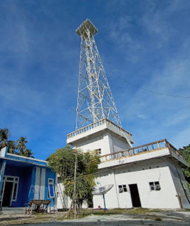
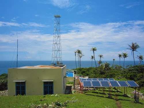
** Breueh (Pulau Brueh, Pulau Bras, Willemstoren)
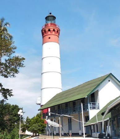
1875. Active; focal plane 160 m (525 ft); two white flashes every 10 s. 44 m (144 ft) round stone tower with lantern and gallery, painted red with one very broad white horizontal band. 5th order clamshell Fresnel lens. This is a staffed station with several station buildings. Syahwal Fazillah has the 2020 photo seen at the top of this page, Akhir Syahputra a the fine 2016 photo, Romi Permana has a 2022 photo, Irhamuddin Guna has a 2013 closeup, Wikimedia has three historic photos from the collection of the Amsterdam Tropenmuseum, and Google has a satellite view. This light marks the extreme northwestern corner of Indonesia, the island of Brueh off the northwestern end of Sumatra.The island of Breueh was devastated by the tsunami of 26 December 2004 but this lighthouse was far above the waves. Some of its support buildings were destroyed by the earthquake, however. Located at the northern tip of Brueh, about 40 km (25 mi) northwest of Banda Aceh. There are ecotours to the island, and the light station is accessible by road; it's a walk of 4 km (2.5 mi) from the nearest fishing village. Site open, tours by the lighthouse staff of the station and tower can be arranged. ARLHS IDO-051; Admiralty F1302; NGA 22236.
Pulau Dedap (Pulau Deudab, Ujung Umpee)
Date unknown. Active; focal plane 40 m (131 ft); white flash every 4 s. 10 m (33 ft) barbell-shaped white fiberglass tower. A view from the sea is available, there's a closeup view at the start of Akmal Riski's video and a view from the beach, and Google has a distant satellite view. Located on a small "island," really a peninsula, at the southeastern tip of Pulau Nasi, an island about 15 km (9 mi) west of Banda Aceh. Accessible only by boat. Site status unknown. Admiralty F1296; NGA 22273.

Banda Aceh City Lighthouses
Banda Aceh, the capital of the Aceh region, is an ancient and historic port; Marco Polo visited the city in 1292. Under the Aceh Sultanate the city was called Kutaraja, the "city of the king." Built on low ground, the city was devastated by the 2004 tsunami, which destroyed 60% of the city's buildings and killed 167,000 of its residents. Largely rebuilt, the city now has a population of more than 250,000.

* Pelabuhan Ulee Lheue (Banda Aceh)
2019. Active; focal plane about 20 m (66 ft); white light, characteristic unknown. Approx. 18 m (59 ft) square skeletal tower. A 2023 closeup photo is available, Agus Kitono has a distant 2022 view, and Google has a satellite view. Located at the ferry terminal in Banda Aceh. Site open, tower closed. Not listed by the Admiralty.
Ulee Lheue (Banda Aceh) Range Front
Between 2005 and 2009. Active; focal plane about 15 m (49 ft); white light, characteristic unknown. Approx. 15 m (49 ft) square skeletal tower painted white and mounted on a square concrete platform supported by piles. Adi Sulay has the 2013 photo seen at right, another photo is available, Yasir Grafis has a drone view, and Google has a satellite view. Ulee Lheue, the harbor district of Banda Aceh, has a new (post-tsunami) ferry port with frequent departures to Pulau Weh, Pulau Breueh, and Pulau Rondo. Located near the mainland shore south of the ferry terminal. Accessible only by boat but easy to view from a waterfront street. Site open, tower closed. It is surprising that these range lights are not listed by the Admiralty and not charted by Navionics.
Ulee Lheue (Banda Aceh) Range Rear
Between 2005 and 2009. Active; focal plane about 22 m (72 ft); white light, characteristic unknown. Approx. 20 m (66 ft) square skeletal tower painted white. No photo available but Google has a satellite view. Located on land about 120 m (400 ft) south of the front light. Site status unknown.

Range Front Light, Banda Aceh, November 2013
Google Maps photo by Adi Sulay

Information available on lost lighthouses:

Notable faux lighthouses:

Adjoining pages: East: Eastern Aceh | South: Northwestern Sumatra | Southwest: Nias

Return to the Lighthouse Directory index | Ratings key

Posted April 13, 2006. Checked and revised December 28, 2023. Lighthouses: 50. Site copyright 2023 Russ Rowlett and the University of North Carolina at Chapel Hill.