Lighthouses of Indonesia: Bangka

The Republic of Indonesia has been independent since 1945 after having been the Dutch East Indies for more than 350 years. It is a huge country, stretching along both sides of the Equator for more than 46 degrees of longitude (roughly 5100 km or 3200 miles). Comprised of some 17,000 islands (more than 6000 inhabited islands), it has hundreds of major aids to navigation.

Indonesia is divided into 38 provinces (provinsi) and the provinces are subdivided into county units called regencies (kabupaten). The province of Bangka Belitung Islands, separated from South Sumatra Province in 2000, includes the islands of Bangka and Belitung off the southeast coast of the much larger island of Sumatra. The narrow Bangka Strait separates Bangka from Sumatra; the Gaspar Strait (usually called the Gelasa Strait in this area) separates Bangka from Belitung, and the broad Karimata Strait separates Belitung from Borneo to the northeast. The Java Sea lies to the south of the islands and the Natuna Sea lies to the north.

This page describes the lighthouses of Bangka; there is a separate page for Belitung. Bangka is a rather large island lying just off the southeast coast of Sumatra; it is about 250 km (150 mi) long and 50 km (30 mi) wide; it has a population of about 1.15 million. Pangkal Pinang, on the east coast, is the provincial capital and largest city of the island.

More than 700 languages are spoken in Indonesia. The official national language, Indonesian (Bahasa Indonesia), was standardized from a form of Malay that served as a lingua franca across the archipelago. In Indonesian a lighthouse is a mercusuar or a menara suar. Tanjung is a cape, ujung is a headland or point of land, bukit is a hill, sungai is a river, kuala or muara is an estuary or river mouth, pulau is an island, karang is a reef, batu is a rock, laut is a sea, selat is a strait, teluk is a bay, pelabuhan is a harbor, and labuhan is a port.

Aids to navigation in Indonesia are operated and maintained by the Directorate of Marine Navigation within the Directorate General of Sea Transportation.

ARLHS numbers are from the ARLHS World List of Lights. Admiralty numbers are from volume Q of the Admiralty List of Lights & Fog Signals. U.S. NGA List numbers are from Publication 112.

General Sources
Online List of Lights - Indonesia
Photos by various photographers posted by Alexander Trabas.
World of Lighthouses - Indonesia
Photos by various photographers available from Lightphotos.net.
Indonesian Lighthouses
Historic postcard views from the collection of Michel Forand.
GPSNauticalCharts
Navigational chart information for Bangka and Belitung.
Navionics Charts
Navigational chart for Bangka and Belitung.

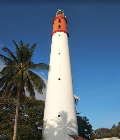
Tanjung Kelian Light, Bangka, January 2020
Google Maps photo by Tjan Sanak Huma
South Bangka Regency: Pulau Lepar and Pulau Pongok Area Lighthouses
Pulau Celaka (Celata, Jelaka) (3?)
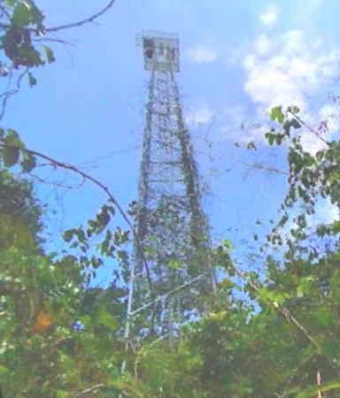
Date unknown (station established 1870). Active; focal plane 32 m (105 ft); two white flashes every 8 s. 30 m (98 ft) square white skeletal tower with gallery. Albert Maramis has a distant view and Google has a satellite view. The original light was listed at a focal plane of 39 m (128 ft) but a 1906 light list has a light with a focal plane of only 16 m (52 ft). Pulau Celaka is an island off the west side of the much larger Pulau Pongok (Liat) in the center of the Gelasa (Gaspar) Strait, which separates Bangka and Belitung islands. The lighthouse guides vessels in the narrow Macclesfield Channel (also called the Leplia Strait) between Pulau Pongok and Pular Lepar, a channel favored by ships sailing between Singapore and Jakarta. Located on the western tip of the island. Accessible only by boat. Site status unknown. ARLHS IDO-178; Admiralty Q1024.5; NGA 22977.
[Pongok Entrance West]
Date unknown. Active; focal plane about 14 m (46 ft); red light, pattern unknown. Approx. 14 m (46 ft) post with gallery mounted on a platform supported by piles. Imam Rahmadi has a photo of the two Pongok lights and a second view of this light and Google has an indistinct satellite view. Located on the west side of the entrance channel for Pelabuhan Pongok, on the west side of Pulau Pongok. Accessible only by boat. Site open, tower closed. Not listed by the Admiralty.
[Pongok Entrance East]
Date unknown. Active; focal plane about 14 m (46 ft); green light, pattern unknown. Approx. 14 m (46 ft) post with gallery mounted on a platform supported by piles. Imam Rahmadi has a photo of the two Pongok lights and Google has an indistinct satellite view. Located on the east side of the entrance channel for Pelabuhan Pongok, on the west side of Pulau Pongok. Accessible only by boat. Site open, tower closed. Not listed by the Admiralty.
Karang Medang (Batu Medang)
Date unknown. Active; focal plane 15 m (49 ft); white flash every 5 s. 15 m (49 ft) white skeletal or fiberglass tower mounted on a platform supported by piles. No photo available and the light is not shown in Google's satellite view. Located in the Java Sea about 30 km (19 mi) east southeast of Pulau Lepar. Accessible only by boat. Site open, tower closed. Admiralty Q1021.8; NGA 22972.5.
Karang Suji (Karang-Karang Suji)
Date unknown. Active; focal plane 12 m (39 ft); two white flashes every 10 s. 12 m (39 ft) white skeletal or fiberglass tower mounted on a platform supported by piles. No photo available and the light is not shown in Google's satellite view. Located in the Java Sea about 90 km (65 mi) east southeast of Pulau Lepar. Accessible only by boat. Site open, tower closed. Admiralty Q1013; NGA 22973.
Tanjung Murung (Pulau Lepar)
Date unknown. Active; focal plane 90 m (295 ft); white flash every 10 s. 30 m (98 ft) square white skeletal tower with gallery. No photo available but Bing has a satellite view. A young visitor has a photo taken atop the tower. Located on a sharp promontory on the southeastern tip of Pulau Lepar, marking the west side of the entrance to the Macclesfield Channel. Site status unknown. Admiralty Q1025; NGA 22978.

South Bangka Regency: Pulau Bangka South Coast Lighthouses
* Sadai
Around 2020. Active; focal plane about 16 m (52 ft0; white light, pattern unknown. Approx. 13 m (43 ft) round white barbell-shaped tower. Intan Andriyani has a 2022 photo, there's a good view of the light in Dimas Prakasa's 2024 video, and Google has a 2024 street view but the lighthouse is not seen in a 2015 street view or in Google's satellite view. Sadai is a port on the southeastern peninsula of Bangka. Located on the Sadai waterfront. Site open, tower closed. Not listed by the Admiralty.
Tanjung Baginda (Tanjung Besar)
Date unknown (2010?). Active; focal plane 23 m (75 ft); two white flashes every 15 s. No description available; this is presumably a white skeletal tower. No photo available and the lighthouse has not been found in Google's satellite view of the cape. This light was added to the NGA list in 2010. Located at the tip of a sharp promontory at the southern tip of Bangka. Site status unknown. Admiralty Q0981.9; NGA 22926.
Pulau Dapur (Kitchen Island)
1889. Active; focal plane 41 m (135 ft); white flash every 10 s. 14 m (46 ft) hexagonal skeletal cast iron tower with lantern and gallery, painted white. Several coast guard buildings. A photo is at right, a closeup and a view from the sea are available and Bing has a satellite view. Located on a small island off the southern tip of Bangka, marking the southeastern entrance to the Bangka Strait. Accessible only by boat. Site status unknown. ARLHS IDO-124; Admiralty Q0982; NGA 22924.

Pulau Dapur Light
Pulau Dapur Light, South Bangka
Bangka-Belitung Dept. of Culture and Tourism photo

* Toboali (2?)
Date unknown. Active; focal plane 32 m (105 ft); white flash every 5 s. Approx. 29 m (95 ft) square skeletal tower, painted white. Google has a street view, the tower is at the left edge of Stefanus Dedy's 2021 photo, and Bing has a satellite view. There was formerly a light at the head of the nearby pier, but Google's street view shows that the pierhead light was removed. Toboali, a town near the southeastern tip of Bangka, is the capital of the South Bangka Regency. Located at the base of the main pier at Toboali. Site open, tower closed. ARLHS IDO-342; Admiralty Q0984; NGA 22908.
Gosong Melvill (Melvill Bank, Western Bank)
Date unknown. Active; focal plane 15 m (49 ft); three green flashes every 9 s. 15 m (49 ft) skeletal or fiberglass tower painted green and mounted on a platform supported by piles. No photo available and the light is not shown in Google's satellite view. This light and the next one guide ships between shoals in the southern Bangka Strait. Located on the west side of the channel in the strait about 8 km (5 mi) southeast of Pulau Besar. Accessible only by boat. Site open, tower closed. Admiralty Q0985; NGA 22912.
Gosong Timur (Eastern Bank)
Date unknown. Active; focal plane 15 m (49 ft); red flash every 5 s. 15 m (49 ft) skeletal or fiberglass tower painted red and mounted on a platform supported by piles. No photo available and the light is not shown in Google's satellite view. This light and the previous one guide ships between shoals in the southern Bangka Strait. Located in the strait about 5 km (3 mi) southeast of Pulau Besar. Accessible only by boat. Site open, tower closed. Admiralty Q0986; NGA 22914.
Pulau Besar (Lampu Besar)
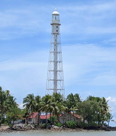
1889. Active; focal plane 61 m (200 ft); two white flashes every 20 s. 57 m (187 ft) octagonal skeletal tower with lantern, gallery, and central cylinder. Entire lighthouse painted white. Five coast guard station buildings. Rara Andhika has the 2018 view from shore seen at right, a closeup photo is available, and Google has a street view and a satellite view. This historic lighthouse is located on the east side of the Strait of Bangka marking the beginning of the narrow portion of the strait. Located on a small island just off a promontory about 3 km (2 mi) southeast of Batubetumpang, on the south coast of Bangka. Accessible only by boat, although there's a good view from shore. Site status unknown. ARLHS IDO-018; Admiralty Q0988; NGA 22904.


Pulau Besar Light, South Bangka, March 2018
Google Maps photo by Rara Andhika

Tanjung Lelari
Date unknown. Active; focal plane 13 m (43 ft); red flash every 10 s. 12 m (39 ft) round red barbell-shaped tower tower mounted on a square platform supported by piles. No photo available but Google has an indistinct satellite view. This light marks the inside of a 45° bend in the Bangka Strait. Located about 600 m (3/8 mi) off the tip of a sharp cape jutting into the southern part of the Bangka Strait. Site status unknown. ARLHS IDO-310; Admiralty Q0990; NGA 22896.
Tanjung Bedawu
Date unknown. Active; focal plane 22 m (72 ft); two white flashes every 15 s. 22 m (72 ft) white square skeletal tower with gallery mounted on a square platform supported by piles. Fahri Setiawan has a 2017 photo, Cintya Lorenza Melden has another photo, and Google has a satellite view. Located just off a cape on the central east coast of the Bangka Strait. Site status unknown. Admiralty Q0991.3; NGA 22878.

Central Bangka Regency West Coast Lighthouse
Pulau Pelepas (Pulau Pelapasan, West Nangka)
1893. Active; focal plane 66 m (217 ft); three white flashes every 30 s. 35 m (115 ft) 12-sided cast iron tower with lantern and gallery, painted white. Several 1-story coast guard buildings. A photo is at right, Fiko Agung has a 2018 closeup, Datuk Kalu has a 2023 view from the sea, Radi El Guitarista has a drone view, and Google has a satellite view. This light marks a right-angle turn in the Bangka Strait and serves as a leading light for traffic in both directions. Located on an island, the westernmost of three islands, on the east side of the strait, about 75 km (45 mi) southeast of Tanjung Kelian. Site status unknown. ARLHS IDO-001; Admiralty Q0992; NGA 22876.

West Bangka Regency Lighthouses
Karang Brom-Brom
Date unknown. Active; focal plane 15 m (49 ft); red flash every 5 s. 10 m (33 ft) skeletal tower painted red and mounted on a square platform supported by piles. No photo available but Bing has a satellite view. Located on a dangerous sand shoal on the north side of the Bangka Strait channel about 25 km (15 mi) southeast of Mentok. Accessible only by boat. Site open, tower closed. Admiralty Q0994; NGA 22880.
* Mentok (Muntok) (2?)
Date unknown (station established 1865). Active; focal plane 32 m (105 ft); white flash every 3 s. Approx. 28 m (92 ft) square skeletal tower with gallery, painted white. Google has a street view and a satellite view. The original light had a focal plane of 12.5 m (41 ft). Muntok, at the north end of Bangka Strait, is the capital of West Bangka Regency. Located at the northeast corner of Mentok harbor. Site open, tower closed. Admiralty Q0996; NGA 22868.


Pulau Pelapas Light, Central Bangka, December 2019
Google Maps photo by Radi El Guitarista

*** Tanjung Kelian (Kalian)
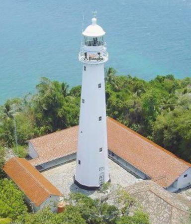
1862. Active; focal plane 38 m (125 ft); white flash every 5 s. 50 m (164 ft) round stone tower with lantern and gallery. Lighthouse painted white with a red horizontal band near the top. Tjan Sanak Huma's photo is at the top of this page, Trabas has an excellent photo by Alfonso Biescas Vignau, a drone view is available, Eko Prasetyo has a 2021 view from the sea, and Google has a street view and a satellite view. Several sources give 1826 as the date of the lighthouse but this is a typo for 1862. This lighthouse guides ships entering the Bangka Strait, which separates Sumatra from Bangka. In March 2006 the lighthouse was vandalized, the thieves taking some of the ironwork. Since then the lighthouse has been restored and has become a very popular attraction. Located on a point of land at the west end of Bangka and the southwest side of Mentok. Accessible by road. Site open, tower open for climbing. ARLHS IDO-041; Admiralty Q0998; NGA 22864.
Karang Haji (Haji Reef)
Date unknown. Active; focal plane 10 m (33 ft); white flash every 5 s. 10 m (33 ft) square skeletal tower with gallery, painted white, mounted on a platform supported by piles. No photo available but Google has a satellite view. Located on a reef about 3 km (1.8 mi) west southwest of Tanjung Kelian. Accessible only by boat. Site open, tower closed. Admiralty Q0998.5.
Karang Ular (Frederick Hendrik Rocks)
Date unknown. Active; focal plane 14 m (46 ft); two white flashes every 5 s. 14 m (46 ft) white tower, probably skeletal, on a platform supported by piles. No photo available and the light is not shown in Google's satellite view. This light marks a dangerous reef on the west side of the northern deep water entrance to the Bangka Strait. Located 19 km (12 mi) due west of Tanjung Ular. Accessible only by boat. Site open, tower closed. Admiralty Q1001; NGA 22860.
Tanjung Ular (2?)
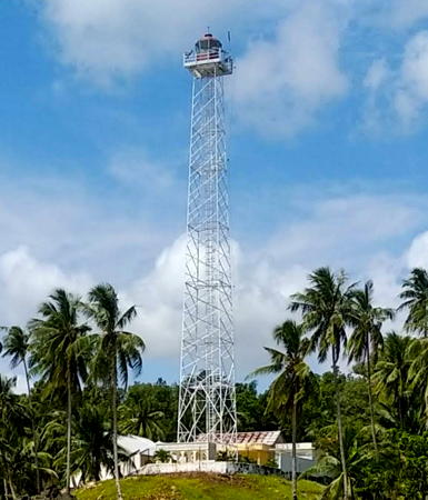
Date unknown (station established 1893). Active; focal plane about 44 m (144 ft); white flash every 19.5 s. 40 m (131 ft) square skeletal tower with lantern and gallery, painted white. Several coast guard station buildings. Muhammad Alfahri has the 2021 photo seen at right, Iwan Resmawan has a 2017 photo, M.farsyah Septa Hartawan has a drone view, and Google has a satellite view. The original lighthouse was similar but its focal plane was only 16 m (52 ft). Located on the northwestern tip of Bangka. Accessible by road, but local guidance is probably needed. Site open, tower closed. ARLHS IDO-333; Admiralty Q1000; NGA 22856.

Tanjung Ular Light, West Bangka, September 2021
Google Maps photo by Muhammad Alfahri

Bangka Regency: North and Northeast Coast Lighthouses
Tanjung Mantong Range Front
Date unknown. Active; focal plane 12 m (39 ft); quick-flashing white light. 12 m (39 ft) square white skeletal tower on a square platform supported by piles. Dewi Eliza Pantja has a sunset 2022 photo and Google has a satellite view and a distant street view. Located about 400 m (1/4 mi) northwest of the rear light (next entry). Accessible only by boat. Site open, tower closed. Admiralty Q1003.; NGA 22969.
Tanjung Mantong Range Rear
Date unknown. Active; focal plane 32 m (105 ft); white light, 2 s on, 2 s off. 30 m (98 ft) square skeletal tower painted white. Muhamad Nur has a photo, Haryo Jati has a distant view from the nearby ferry pier, and Google has a street view and a satellite view. Located at Belinyu, a small port on the east side of Teluk Klabat, a protected harbor on the north coast of Bangka. Site status unknown, but the tower is easy to see from nearby. Admiralty Q1003.1; NGA 22969.1.
Teluk Klabat (Pulau Penyusu)
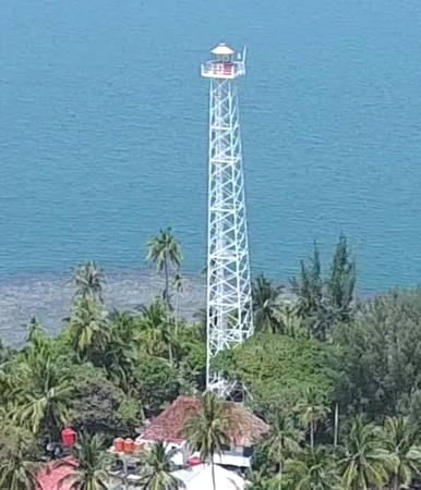
Date unknown. Active; focal plane 36 m (118 ft); white flash every 7.5 s. 40 m (131 ft) square skeletal tower with lantern and gallery, painted white. 1-story coast guard building. M.farsyah Septa Hartawan has the drone view seen at right, Suhandi Widjaja has a distant street view from the mainland, and Google has a satellite view of the station. Located on an islet off a promontory at the east side of the entrance to Teluk Klabat. Accessible only by boat, although there's probably a good view from shore. Site status unknown. ARLHS IDO-025; Admiralty Q1002; NGA 22968.
[Tanjung Tuing]
Date unknown. Active; focal plane 50 m (164 ft); white flash every 6 s. 12 m (39 ft) square white skeletal mast. The tip of the tower is see near the left edge of Budi Suriansyah's photo and Google has an indistinct satellite view. Located on a prominent cape at the northeastern corner of Bangka. Site status unknown. ARLHS IDO-332; Admiralty Q1004; NGA 22956.
* [Tanjung Raja]
Date unknown. Active; focal plane 30 m (98 ft); white flash every 6 s. Approx. 15 m (49 ft) white mast centered on a square platform supported by piles. Google has a closeup street view and a satellite view showing the square platform. Located near the Padepokan Puri Tri Agung temple on a prominent cape about 35 km (22 mi) north of Pangkal Pinang. Site open, tower closed. Admiralty Q1005; NGA 22952.
Karang Merah
Date unknown. Active; focal plane 12 m (39 ft); two green flashes every 15 s. 12 m (39 ft) "green beacon," probably a skeletal or fiberglass tower on a platform supported by piles. No photo available and the light is not shown in Google's satellite view. Located in the Natuna Sea about 25 km (15 mi) northeast of Pangkal Pinang. Accessible only by boat. Site open, tower closed. Admiralty Q1007; NGA 22948.
Karang Hidrograf Timur (East Hydrograph Reef)
Date unknown. Active; focal plane 13 m (43 ft); white flash every 4 s. 13 m (43 ft) white barbell-shaped fiberglass tower on a platform supported by piles. No photo available and the light is not shown in Google's satellite view. Located on a notorious reef about 45 km (28 mi) east northeast of Pangkal Pinang. Accessible only by boat. Site open, tower closed. Admiralty Q1005.4; NGA 22957.

Teluk Klabat (Pulau Penyusu) Light, Bangka, June 2018
Google Maps drone view by M.farsyah Septa Hartawan

Pangkal Pinang City and Approaches Lighthouses
Karang Elliot (General Elliot Reef)
Date unknown. Active; focal plane 15 m (49 ft); white (?) light, 3 s on, 15 s off. 15 m (49 ft) skeletal tower mounted on a platform supported by piles. No photo available and the light is not shown in Bing's satellite view. Navionics charts the light as green, which would be appropriate for this location. This light and the next one bracket the approach to Pangkal Pinang. Located in the Natuna Sea about 25 km (15 mi) northeast of Pangkal Pinang. Accessible only by boat. Site open, tower closed. Admiralty Q1006; NGA 22960.
Karang Miang (2?)
Date unknown. Active; focal plane 15 m (49 ft); red flash every 4 s. 15 m (49 ft) square red skeletal (?) tower mounted on a platform supported by piles. No photo available; Bing's satellite view suggests the skeletal tower has been replaced by a post or fiberglass tower. Located in the Natuna Sea about 20 km (13 mi) east of Pangkal Pinang. Accessible only by boat. Site open, tower closed. Admiralty Q1006.5; NGA 22964.
Pangkal Pinang Entrance Channel North
Date unknown. Active; focal plane about 12 m (39 ft); green light, pattern unknown. Approx. 12 m (39 ft) square skeletal tower painted green and mounted on a square platform supported by piles. No photo available but Bing has a satellite view. Located on a shoal on the northern edge of the entrance channel to Pangkal Pinang. Accessible only by boat. Site open, tower closed. Admiralty Q1008.03.
Pangkal Pinang Entrance Channel South
Date unknown. Active; focal plane about 12 m (39 ft); red light, pattern unknown. Approx. 12 m (39 ft) square skeletal tower painted red and mounted on a square platform supported by piles. No photo available but Bing has a satellite view. Located on a shoal on the south side of the entrance channel to Pangkal Pinang. Accessible only by boat. Site open, tower closed. Admiralty Q1008.05.
Pangkal Pinang (Pangkalbalam) Range Front (2?)
Date unknown. Active; focal plane about 12 m (39 ft); white flash every 3 s. Approx. 12 m (39 ft) square skeletal tower painted white and mounted on a square platform supported by piles. A 2021 drone view is available, Reza Arlianda has a distant street view, Edi Rahman has a very distant street view, and Bing has a satellite view. NGA lists a tower with a focal plane of 8 m (26 ft), but the tower appears taller than this listed height. Pangkal Pinang is the capital and largest city of Bangka-Belitung Province, with a population of about 330,000, but it is not a major seaport. Located at the entrance to a small estuary that serves as the city's harbor. Accessible only by boat. Site open, tower closed. Admiralty Q1008; NGA 22946.
Pangkal Pinang (Pangkalbalam) Range Rear (2?)
Date unknown. Active; focal plane about 20 m (66 ft); white flash every 5 s. Approx. 20 m (66 ft) square skeletal tower painted white and mounted on a square platform supported by piles. A 2021 drone view is available (a portion is seen at right), Reza Arlianda has a street view across the river, and Bing has a satellite view. NGA lists a tower with a focal plane of 14 m (46 ft), but the tower appears taller than this listed height. Located 926 m (0.58 mi) west northwest of the front light. Accessible only by boat. Site open, tower closed. Admiralty Q1008.1; NGA 22946.5.
Pangkalbalam
Date unknown. Active; focal plane 10 m (33 ft); green flash every 3 s. 10 m (33 ft) square skeletal tower painted white and mounted on a square platform supported by piles. No photo available but Google has a satellite view. Located just off the north bank of the Baturusa estuary opposite downtown Pangkal Pinang. Accessible only by boat. Site open, tower closed. Admiralty Q1008.3.

Rear Range Light, Pangkal Pinang, May 2021
Google Maps drone view by Ifan Videografi
* Tanjung Bunga
Date unknown. Active; focal plane 30 m (98 ft); white flash every 5 s. 20 m (66 ft) square white skeletal tower with gallery. No photo available but Google has a satellite view and a distant street view. This lighthouse is close to Kelenteng Dewi Laut, a well-known Buddhist temple. Located at the tip of a promontory on the south side of the entrance to Pangkal Pinang. Site probably open, tower closed. ARLHS IDO-298; Admiralty Q1009; NGA 22940.

Central Bangka Regency East Coast Lighthouses
Karang Gosong
Date unknown. Active; focal plane 13 m (43 ft); green flash every 5 s. 13 m (43 ft) skeletal tower mounted on a square platform supported by piles. No photo available but Bing has a satellite view of the platform. Located on a shoal about 8 km (5 mi) southeast of the entrance to Pangkal Pinang. Accessible only by boat. Site open, tower closed. Admiralty Q1010; NGA 22944.
Pulau Bebuar (Pulau Beboear)
Date unknown. Active; focal plane 43 m (141 ft); three white flashes every 10 s. Approx. 40 m (131 ft) skeletal tower, painted white. Only a fuzzy distant view is available and the tower is not conspicuous in Bing's satellite view of the station. Located on a small island, the easternmost of a chain of islands, southeast of Pangkal Pinang. Accessible only by boat. Site status unknown. Admiralty Q1010.7; NGA 22934.
Karang Van Sittard
Date unknown. Active; focal plane 13 m (43 ft); two white flashes every 5 s. 13 m (43 ft) skeletal or fiberglass tower, painted black with one red horizontal band and mounted on a square platform supported by piles. No photo available and the light is not shown in Google's satellite view. Located on an isolated reef about 45 km (28 mi) north northwest of Tanjung Berikat. Accessible only by boat. Site open, tower closed. Admiralty Q1005.7; NGA 22958.
Tanjung Berikat
Date unknown. Active; focal plane 46 m (151 ft); three white flashes every 15 s. 30 m (98 ft) square skeletal tower with gallery, painted white. Gawai Kerja's 2023 photo is at right, Rizwar d'laze has a distant view, another distant view is available and Google has a satellite view. This lighthouse marks the northern entrance to the Gelasa (Gaspar) Strait, which separates Bangka and Belitung islands. Located on a sharp promontory at the southeastern corner of Bangka. Site status unknown. ARLHS IDO-037; Admiralty Q1012; NGA 22932.
Pulau Berikat
Date unknown. Active; focal plane 15 m (49 ft); two white flashes every 6 s. 10 m (33 ft) skeletal tower painted white and mounted on a square platform supported by piles. No photo available but Google has a distant satellite view. An older and shorter beacon is just to the east of the active light. Located on a small island about 20 km (13 mi) east northeast of Tanjung Berikat. Accessible only by boat. Site status unknown. Admiralty Q1012.5; NGA 22933.

Tanjung Berikat Light, Bangka, September 2023
Google Maps photo by Gawai Kerja

Information available on lost lighthouses:

Notable faux lighthouses:

Adjoining pages: North: Bintan and Lingga | East: Belitung | South: North West Java | West: Eastern Sumatra

Return to the Lighthouse Directory index | Ratings key

Posted April 13, 2006. Checked and revised March 27, 2024. Lighthouses: 38. Site copyright 2024 Russ Rowlett and the University of North Carolina at Chapel Hill.