Lighthouses of Indonesia: Belitung

The Republic of Indonesia has been independent since 1945 after having been the Dutch East Indies for more than 350 years. It is a huge country, stretching along both sides of the Equator for more than 46 degrees of longitude (roughly 5100 km or 3200 miles). Comprised of some 17,000 islands (more than 6000 inhabited islands), it has hundreds of major aids to navigation.

Indonesia is divided into 38 provinces (provinsi) and the provinces are subdivided into county units called regencies (kabupaten). The province of Bangka Belitung Islands, separated from South Sumatra Province in 2000, includes the islands of Bangka and Belitung off the east coast of the much larger island of Sumatra. The narrow Bangka Strait separates Bangka from Sumatra; the Gaspar Strait (usually called the Gelasa Strait in this area) separates Bangka from Belitung, and the broad Karimata Strait separates Belitung from Borneo to the northeast. The Java Sea lies to the south of the islands and the Natuna Sea lies to the north.

This page describes the lighthouses of Belitung; there is separate page for Bangka. Belitung is about 80 km (50 mi) in diameter and has a population of about 310,000. Tanjung Pandan is its main port and largest city.

More than 700 languages are spoken in Indonesia. The official national language, Indonesian (Bahasa Indonesia), was standardized from a form of Malay that served as a lingua franca across the archipelago. In Indonesian a lighthouse is a mercusuar or a menara suar. Tanjung is a cape, ujung is a headland or point of land, bukit is a hill, sungai is a river, kuala or muara is an estuary or river mouth, pulau is an island, karang is a reef, batu is a rock, laut is a sea, selat is a strait, teluk is a bay, pelabuhan is a harbor, and labuhan is a port.

Aids to navigation in Indonesia are operated and maintained by the Directorate of Marine Navigation within the Directorate General of Sea Transportation.

ARLHS numbers are from the ARLHS World List of Lights. Admiralty numbers are from volume Q of the Admiralty List of Lights & Fog Signals. U.S. NGA List numbers are from Publication 112.

General Sources
Online List of Lights - Indonesia
Photos by various photographers posted by Alexander Trabas.
World of Lighthouses - Indonesia
Photos by various photographers available from Lightphotos.net.
Indonesian Lighthouses
Historic postcard views from the collection of Michel Forand.
GPSNauticalCharts
Navigational chart information for Bangka and Belitung.
Navionics Charts
Navigational chart for Bangka and Belitung.

Tanjung Ajer Lancur Light, Gelasa Strait, June 2017
Google Maps photo by Robert Elreal
Belitung Regency: Gelasa Strait Islands Lighthouses
The Gelasa Strait separating Bangka and Belitung is strewn with reefs and shoals. These bits of land are all assigned to Belitung Regency rather than South Bangka Regency on the west side of the strait.

Pulau-Pulau Masar (Kennedy Island)
Date unknown. Active; focal plane 22 m (72 ft); two white flashes every 15 s. Approx. 20 m (66 ft) white skeletal tower. No photo available but Bing has a satellite view. Located on an islet about 20 km (13 mi) off the south coast of Belitung. Accessible only by boat. Site open, tower closed. Admiralty Q1020.7; NGA 22972.25.
Karang Genting
Date unknown. Active; focal plane 10 m (33 ft) (?); white flash every 5 s. Described as a "whute beacon" with a range of 11 nautical miles; this suggests the focal plane is higher than listed. Probably a white skeletal or fiberglass tower on a platform supported by piles. No photo available and the light is not shown in Google's satellite view. Located on a shoal about 8 km (5 mi) southwest of Kennedy Island. Accessible only by boat. Site open, tower closed. Admiralty Q1021; NGA 22974.
Karang Batu Malang
Date unknown. Active; focal plane 13 m (43 ft); white flash every 5 s. 13 m (43 ft) white skeletal or fiberglass tower on a platform supported by piles. No photo available and the light is not shown in Google's satellite view. Located about 3.5 km (2 mi) west of Pulau Seliu, an island off the southwest corner of Belitung. Accessible only by boat. Site open, tower closed. Admiralty Q1020.5; NGA 22972.2.
Pulau Sumedang (Pulau Simedang, Shoalwater Island)
1883. Active; focal plane 61 m (200 ft); two white flashes every 20 s. 57 m (187 ft) 16-sided cast iron tower with lantern and gallery, painted white. Several 1-story coast guard buildings. Ardi Pradhana has a 2019 photo (also seen at right) and drone view, Suratman Trautman has a distant view from the sea, and Bing has a good satellite view of the station. Welcoming northbound ships to the Gelasa (Gaspar) Strait, this lighthouse is in the Java Sea about 80 km (50 mi) southeast of Bangka and 50 km (30 mi) southwest of Belitung. Accessible only by boat. Site open, tower closed. ARLHS IDO-029; Admiralty Q1020; NGA 22972.
Karang-Karang Baginda
Date unknown. Active; focal plane 15 m (49 ft); green flash every 7 s. 15 m (49 ft) green skeletal or fiberglass tower mounted on a platform supported by piles. No photo available and the light is not shown in Google's satellite view. Located in the Java Sea about 16 km (10 mi) southeast of Pulau Lepar. Accessible only by boat. Site open, tower closed. Admiralty Q1021.6; NGA 22972.3.

Pulau Sumedang Light, Java Sea, May 2019
Google Maps photo by Ardi Pradhana
Pulau Kasenga
Date unknown. Active; focal plane 20 m (66 ft); white flash every 5 s. 18 m (59 ft) mast painted with red and white horizontal bands and mounted on a square platform supported by piles. No photo available but Bing has a fuzzy satellite view. This light guides northbound vessels entering the Gelasa (Gaspar) Strait between Belitung and Bangka. Located off a small island southwest of the southwestern point of Belitung. Accessible only by boat. Site status unknown. ARLHS IDO-146; Admiralty Q1022; NGA 22980.
Pulau Selemar
Date unknown. Active; focal plane 14 m (46 ft); green flash every 5 s. Approx. 13 m (43 ft) square skeletal tower painted green. A very distant view from the sea is available (zoom for a better view) and Bing has a distant satellite view. Located on an islet about 8 km (5 mi) south of Pulau Pongok (Liat). Accessible only by boat. Site status unknown. Admiralty Q1024.7; NGA 22977.5.
Karang Tominkor
Date unknown. Active; focal plane 13 m (43 ft); white flash every 3 s. 13 m (43 ft) white skeletal or fiberglass tower on a platform supported by piles. No photo available and the light is not shown in Google's satellite view of the reef. Located on a large reef about 8 km (5 mi) southeast of Pulau Lait in South Bangka Regency. Accessible only by boat. Site open, tower closed. Admiralty Q1024.2; NGA 22975.
Karang Pandan
Date unknown. Active; focal plane 13 m (43 ft); two white flashes every 5 s. 13 m (43 ft) skeletal or fiberglass tower, painted black with one red horizontal band and mounted on a square platform supported by piles. No photo available and the light is not shown in Google's satellite view. Located on an isolated and dangerous reef in the middle of the Gelasa Strait halfway between Pulau Liat on the Bangka side and Pulau Mendanau on the Belitung side. Accessible only by boat. Site open, tower closed. Admiralty Q1024.1; NGA 22975.5.

Belitung Regency: West Coast Lighthouses
** Tanjung Ajer Lancur (Tanjung Ajer Lantjoer, Tanjung Ayerlancur, Pulau Mendanau)
1882. Active; focal plane 62 m (203 ft); three white flashes every 20 s. 27 m (89 ft) 12-sided cast iron tower with lantern and gallery, painted white. Robert Elreal's drone view is at the top of this page, Frey Jabink has a closeup photo, Dwi Andini has a 2019 closeup, Farboong Uyye has a 2021 photo, and Google has a satellite view of the station. This historic lighthouse is in good condition. Located at the western point of the island of Mendanau, off the west coast of Belitung. Accessible only by boat. Site open and staff are willing to conduct tours. ARLHS IDO-036; Admiralty Q1024; NGA 22976.
Pulau Langir
Date unknown. Active; focal plane 22 m (72 ft); two white flashes every 15 s. Approx. 18 m (59 ft) white skeletal tower. The tower is seen in a video, a view of the interior of the tower is available, and Google has an indistinct satellite view. The light guides ships approaching Tanjung Pandan. Located on a small island off the northwestern point of the island of Mendanau. Site status unknown. Admiralty Q1024.05; NGA 22976.5.
Tanjung Pandan Approach
Date unknown. Active; focal plane 13 m (43 ft); two green flashes every 8 s. 13 m (43 ft) round green tower mounted on a triangular platform supported by piles. No photo available but Bing has an indistinct satellite view. Located on the south side of the approach channel to the port of Tanjung Pandan. Accessible only by boat. Site open, tower closed. Admiralty Q1028; NGA 23000.

Harbor Light, Tanjung Pandan, November 2015
Google Maps street view
* Tanjung Pandan Harbor
Date unknown. Active; focal plane 24 m (79 ft); white flash every 5 s. Approx. 22 m (72 ft) square skeletal tower with gallery, painted white. Tjan Sanak Huma has a view from the harbor, Doddy Alexandra has a sunset photo, and Google has a street view (also seen above right) and a satellite view. Located on the waterfront of Tanjung Pandan, a port on the west side of Belitung and the capital of Belitung Regency. Site open, tower closed. ARLHS IDO-319; Admiralty Q1028.8; NGA 22998.
Pulau Lengkuas (Langkuas)
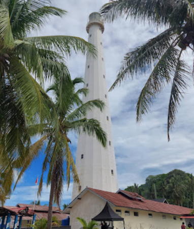
1883. Active; focal plane 61 m (200 ft); white flash every 7.5 s. 57 m (187 ft) 16-sided cast iron tower, painted white with lantern and gallery. Several coast guard station buildings. Paulus Budianto's 2022 photo is at right, Datuk Kalu has a 2023 photo, Varo Dhaniswara has a closeup 2023 photo, Bimo Pakusadewa has a 2016 street view, Kawi Boedisetio has a view from the sea, and Google has a satellite view of the station. This lighthouse is just off the northwestern point of Belitung, facing the entrance to the Gelasa Strait. It was prefabricated by Enthoven at The Hague. Site status unknown. ARLHS IDO-010; Admiralty Q1030; NGA 22984.

East Belitung Regency: East Coast Lighthouses
[Pulau Kanis (Pulau Pekandis)] (2?)
Around 2015. Active; focal plane 12 m (39 ft); two white flashes every 8 s. 10 m (33 ft) white post on a platform supported by piles. A very distant view (lighthouse on the left) is available and the light is a fuzzy spot in Bing's satellite view. NGA lists the light as "Northeast Coast." Located on a small island off the northeast coast of Belitung. Accessible only by boat. Site open, tower closed. Admiralty Q1032; NGA 22988.
[Tanjung Kluang]
Date unknown. Active; focal plane about 18 m (59 ft); white light, pattern unknown. Approx. 15 m (49 ft) steel mast painted with red and white bands. The mast is at the left edge of a 2016 photo and in front of a blue-roofed building on the right in a 2017 photo, and its shadow is seen in Google's satellite view. The red and white bands are visible (with zoom) in Rudi Makmur's distant October 2017 view; earlier the mast was all white. Tanjung Kluang is an oil terminal on the northeast coast of Belitung. Located on the waterfront of the port. Site status unknown. Admiralty Q1031.5.

Pulau Lengkuas Light, Belitung, June 2022
Google Maps photo by Paulus Budianto
Manggar Approach North
Date unknown. Active; focal plane about 13 m (43 ft); green light, pattern unknown. Approx. 13 m (43 ft) green skeletal tower on a square platform supported by piles. Eriko Utama has a very distant street view and Google has an indistinct satellite view. Located on the north side of the deep water approach to Manggar. Accessible only by boat. Site open, tower closed. Admiralty Q1032.8.
Manggar Approach South
Date unknown. Active; focal plane about 13 m (43 ft); red light, pattern unknown. Approx. 13 m (43 ft) red skeletal tower on a square platform supported by piles. Eriko Utama has a distant street view and Google has an indistinct satellite view. Located on the south side of the deep water approach to Manggar. Accessible only by boat. Site open, tower closed. Admiralty Q1032.7.
Manggar Entrance North
Date unknown. Active; focal plane 30 m (98 ft); white flash every 3 s. Approx. 27 m (89 ft) square skeletal tower, painted white. Eriko Utama has a street view and Google has a satellite view. NGA has confused the two Manggar lights, combining the location of this light and the data for the south light into a single listing. Located on the north side of Manggar, the capital of the East Belitung Regency. Site status unknown. Admiralty Q1032.3.
* Manggar Entrance South
Date unknown. Active; focal plane 22 m (72 ft); white flash every 5 s. Approx. 19 m (62 ft) square skeletal tower. Eriko Utama has a photo and a street view (a portion is seen at right), Onedes Sipahutar has a 2019 sunset photo, and Google has a satellite view. Located on the south side of the entrance to Manggar. Site open, tower closed. Admiralty Q1032.5; NGA 22990.
[Manggar Southwest]
Date unknown. Active; focal plane about 13 m (43 ft); light characteristics unknown. Approx. 10 m (33 ft) post mounted on a square stone base. Mifta Lalang has a 2023 photo and William Susanto has a fuzzy drone view but the post is not seen in Google's distant satellite view. Located at a small estuary entrance on the south side of Manggar. Site status unknown. Admiralty Q1032.6.

Entrance South Light, Manggar, June 2016
Google Maps photo by Eriko Utama

East Belitung Regency: Karimata Strait Lighthouses
Pulau Pesemut
Date unknown. Active; focal plane 43 m (141 ft); one long white flash every 5 s. 40 m (131 ft) tapered square skeletal tower with gallery, painted white. Four 1-story coast guard buildings. A photo is at right, a small photo and another small photo are available, and Bing has a satellite view of the station. This lighthouse marks the end of the long reef of the Momperang Islands extending eastward from Belitung; it is of crucial importance for vessels in the Karimata Strait. It is a staffed station; crews of three serve four month assignments. The conservation organization YPLI pays the keepers to guard the nests of sea turtles on the island and refrain from selling the eggs to passing fishermen. Located on a low island in the strait about 65 km (40 mi) northeast of Belitung. Accessible only by boat. Site status unknown. ARLHS IDO-240; Admiralty Q1033; NGA 25056.
Karang Batuan
Date unknown. Active; focal plane 13 m (43 ft); two white flashes every 10 s. 13 m (43 ft) skeletal or fiberglass tower, painted black with one red horizontal band and mounted on a square platform supported by piles. No photo available and the light is not shown in Google's satellite view. Located on a shoal about 50 km (30 mi) east of the southeastern corner of Belitung. Accessible only by boat. Admiralty Q1033.8; NGA 25051.
Gosong Mampango (Discovery East Bank) (2)
Date unknown (station established 1903). Active; focal plane 13 m (43 ft); white flash every 5 s. 13 m (43 ft) "white beacon" on a square platform supported by piles. A very fuzzy photo is available and Bing has a very distant satellite view of the reef. The light is an important guide for northbound vessels entering the Karimata Strait. In January 2010 the Irish racing yacht Cork Clipper wrecked near the light, bringing it briefly to international attention. Lightphotos.net has a historic photo of the original Dutch lighthouse, said to have been destroyed in World War II. (This photo is from a Java Post article.) Located on a dangerous reef far out in the northwestern corner of the Java Sea, about 200 km (125 mi) east southeast of Belitung and a similar distance southwest of the southwestern corner of Kalimantan. Accessible only by boat. Site status unknown. ARLHS IDO-132; Admiralty Q1034; NGA 25052.
Karang Selatan (South Reef)
Date unknown. Active; focal plane 11 m (36 ft); white flash every 3 s. 11 m (36 ft) white fiberglass tower on a platform supported by piles. No photo available and the light is not shown in Google's satellite view. NGA misspells the name as Satatan. Located on a shoal about 40 km (25 mi) southeast of Belitung. Accessible only by boat. Site open, tower closed. Admiralty Q1033.5; NGA 25054.

Pulau Pesemut Light, Karimata Strait
photo posted by YPLI
Gosong Abadi
Date unknown. Active; focal plane 13 m (43 ft); two white flashes every 10 s. 13 m (43 ft) skeletal or fiberglass tower, painted black with one red horizontal band and mounted on a square platform supported by piles. No photo available and the light is not shown in Google's satellite view. Located on a shoal about 65 km (40 mi) south southeast of Belitung. Accessible only by boat. Site open, tower closed. Admiralty Q1033.6; NGA 25053.
Karang Beli (Pulau Kebatu)
Date unknown. Active; focal plane 15 m (49 ft); white light, 3 s on, 15 s off. 15 m (49 ft); white skeletal tower mounted on a platform supported by piles. No photo available and the light is not shown in Google's satellite view. Located in the Java Sea about 50 km (30 mi) south of the southern tip of Belitung. Site open, tower closed. Admiralty Q1021.5; NGA 22974.5.

Information available on lost lighthouses:

Notable faux lighthouses:

Adjoining pages: North: Bintan and Lingga | East: West Kalimantan | South: North West Java | West: Bangka

Return to the Lighthouse Directory index | Ratings key

Posted April 13, 2006. Checked and revised April 4, 2024. Lighthouses: 26. Site copyright 2024 Russ Rowlett and the University of North Carolina at Chapel Hill.