Lighthouses of Indonesia: West Kalimantan (Borneo)

The Republic of Indonesia has been independent since 1945 after having been the Dutch East Indies for more than 350 years. It is a huge country, stretching along both sides of the Equator for more than 46 degrees of longitude (roughly 5100 km or 3200 miles). Comprised of some 17,000 islands (more than 6000 inhabited islands), it has hundreds of major aids to navigation.

Borneo, known as Kalimantan in Indonesia, is the world's third largest island. 73% of the island is Indonesian; the remaining portion includes the Malaysian states of Sarawak and Sabah and the independent sultanate of Brunei. Indonesian Kalimantan is separated from Sulawesi (Celebes) to the east by the Makassar Strait, from Java to the south by the Java Sea, and from Sumatra to the southwest by the Karimata Strait and Natuna Sea.

Indonesia is divided into 38 provinces (provinsi) and the provinces are subdivided into county units called regencies (kabupaten). This page describes lighthouses of West Kalimantan Province, which occupies the southwestern corner of Borneo with a coast that faces west on the Karimata Strait and Natuna Sea.

More than 700 languages are spoken in Indonesia. The official national language, Indonesian (Bahasa Indonesia), was standardized from a form of Malay that served as a lingua franca across the archipelago. In Indonesian a lighthouse is a mercusuar or a menara suar. Tanjung is a cape, ujung is a headland or point of land, bukit is a hill, sungai is a river, kuala or muara is an estuary or river mouth, pulau is an island, karang is a reef, batu is a rock, laut is a sea, selat is a strait, teluk is a bay, pelabuhan is a harbor, and labuhan is a port.

Aids to navigation in Indonesia are operated and maintained by the Directorate of Marine Navigation within the Directorate General of Sea Transportation

ARLHS numbers are from the ARLHS World List of Lights. Admiralty numbers are from volumes F and Q of the Admiralty List of Lights & Fog Signals. U.S. NGA List numbers are from Publication 112.

General Sources
Online List of Lights - Indonesia - Kalimantan - Vol. F and Vol. Q
Photos by various photographers posted by Alexander Trabas.
Indonesian Lighthouses
Historic postcard views from the collection of Michel Forand.
World of Lighthouses - Indonesia
Photos by various photographers available from Lightphotos.net.
GPSNauticalCharts
Navigational chart information for West Kalimantan.
Navionics Charts
Navigation chart for southern Kalimantan.

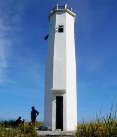
Pulau Sitinjan Light, Karimata Strait, January 2018
Google Maps photo by Budi Ponty
Ketapang Regency Lighthouses
Sukamara (Sungai Jelai) Range Rear
Date unknown. Active; focal plane about 13 m (43 ft); white light, pattern unknown. Approx. 13 m (43 ft) square skeletal tower on a platform supported by piles. No photo available but Google has an indistinct satellite view. This is the entrance range for the Jelai River, which forms part of the border between Central Kalimantan and West Kalimantan. The front light is on a shorter skeletal tower. Accessible only by boat. Site open, tower closed. Admiralty Q1410.61.
Gosong Mangkut
Date unknown. Active; focal plane 15 m (49 ft); two white flashes every 5 s. 15 m (49 ft) tower, painted black with one red horizontal band. No photo available and the islet is barely visible in Google's distant satellite view. Located on a shoal about 16 km (10 mi) southwest of Tanjung Sambar, the southwestern tip of Kalimantan. Accessible only by boat. Site open, tower closed. Admiralty Q1410.3; NGA 25049.
Gosong Aling (New Fox Bank, Fox Banks)
Date unknown. Active; focal plane 14 m (46 ft); four white flashes every 20 s. 14 m (46 ft) white skeletal tower, presumably on a platform supported by piles. No photo available and the light is not shown in Google's satellite view. Located on the east side of the shipping lanes at the southern entrance to the Karimata Strait, about 55 km (35 mi) southwest of Tanjung Sambar, the southwestern tip of Kalimantan. Accessible only by boat. Site open, tower closed. Admiralty Q1036; NGA 25048.
Pulau Bawal (Tanjung Rotan)
Date unknown. Active; focal plane 67 m (220 ft); three white flashes every 12 s. 30 m (98 ft) square skeletal tower painted white. No photo available but Bing has a very distant satellite view. Pulau Bawal is an island about 10 km (6 mi) northwest of Tanjung Sambar. Site status unknown. Admiralty Q1410; NGA 25050.
* [Pelabuhan Kendawangan]
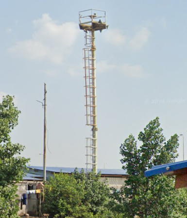
Date unknown. Active; focal plane about 16 m (52 ft); light characteristic unknown. Approx. 13 m (43 ft) mast. Zaenal Zaenul has a photo, Google has a 2023 street view, and Bing has a distant satellite view. Kendawangan is a city of about 185,000 residents about 15 km (9 mi) north of Tanjung Sambar; its port ships bauxite and palm oil. Located on the quay at Kendawangan. Site open, tower closed. Not listed by the Admiralty.
Kendawangan Range Front
Date unknown. Active; focal plane 10 m (33 ft); white light, 1 s on, 1 s off. 10 m (33 ft) white skeletal tower on a platform supported by piles. No photo available but Google has a distant satellite view. Located off the north side of the entrance to Kendawangan. Accessible only by boat. Site open, tower closed. Admiralty Q1409.8.
Kendawangan Range Rear
Date unknown. Active; focal plane 13 m (43 ft); white light, 2 s on, 2 s off. Approx. 20 m (66 ft) white skeletal tower. No photo available but Google has an indistinct satellite view. Located on the beach about 200 m (1/8 mi) northwest of the front light. Site status unknown. Admiralty Q1409.81.
Karang Onrust
Date unknown. Active; focal plane 12 m (39 ft); white flash every 5 s. 12 m (39 ft) tower, form unknown, presumably on a platform supported by piles, painted black with one red horizontal band. No photo available and the light is not shown in Google's satellite view. Located on a reef about 15 km (9 mi) southwest of Ketapang. Accessible only by boat. Site open, tower closed. Admiralty Q1409.5.
Pelabuhan Sukabangun (Ketapang Harbor)
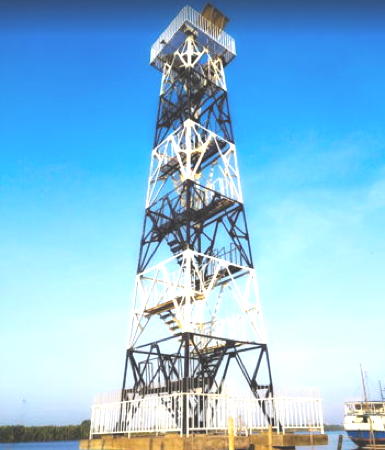
Date unknown. Active; focal plane about 22 m (72 ft); flash every 5 s, white or green depending on direction. Approx. 20 m (66 ft) square skeletal tower painted with black and white horizontal bands. Mariani Rinn has the 2020 closeup photo at right, the light is at the right edge of a photo of the waterfront, and Google has a May 2024 satellite view (lighthouse just off the left end of the quay). Ketapang is the regency capital. Located at Ketapang's principal harbor on the south bank of the Pawan River. Site status unknown. Admiralty Q1408.3; NGA 25067.
Ketapang Approach (Tanjung Adung) Range Rear
Date unknown. Active; focal plane about 22 m (72 ft); white light occulting once every 4 s. Approx. 20 m (66 ft) square white skeletal tower. No photo available but Google has a satellite view. This is the approach range for the Kandangkerbau River and Ketapang. The front light is on a platform offshore. Located on Tanjung Adung, on the north side of the river's mouth. Site status unknown. Admiralty Q1408.1; NGA 25066.
Ketapang Outbound Range Rear (2)
Date unknown. Active; focal plane about 20 m (66 ft); white light, 2 s on, 2 s off. White tower, form unknown, on a platform supported by piles. No photo available but Google has a satellite view. The range guides vessels leaving the Kandangkerbau River and Ketapang. An earlier light was only 8 m (26 ft) tall. Located off the south side of the river entrance. Accessible only by boat. Site open, tower closed. Admiralty Q1409.1.; NGA 25066.4.

Pelabuhan Sukabangun Light, Ketapang, August 2020
ex-Google Maps photo by Mariani Rinn

Kayong Utara (North Kayong) Regency: Karimata Islands Lighthouses
The Karimata Islands are a group of small islands off the Kalimantan coast in the northern entrance to the Karimata Strait. The shipping lanes in the strait veer to the west to avoid the islands.

Karang Ontario (Ontario Reef)
Date unknown. Reported inactive in 2020; listed with focal plane 15 m (49 ft); two white flashes every 5 s. 15 m (49 ft) tower, painted black with one red horizontal band. No photo available and the light is not shown in Google's satellite view. The Admiralty dropped this light in April 2020 but it is an important beacon and may still be active; the safe shipping channel of the Karimata Strait lies between this light and the Pulau Serutu light (next entry) Located on a coral reef 31 km (19.5 mi) south southwest of Palau Serutu. Accessible only by boat. Site status unknown. ex-Admiralty Q1405.5; NGA 25058.
Pulau Serutu
1902. Active; focal plane 175 m (574 ft); three quick white flashes every 10 s. 25 m (82 ft) octagonal cast iron skeletal tower with lantern and gallery, painted white. A 2024 photo is at right, there's a closeup of the tower in Tambas Aulia's video, and Google has a satellite view of the station. This is a major light with a range of 36 nautical miles (67 km, 42 mi). There is a proposal to protect the light station as a heritage area and the province's cultural survey team has a 2017 photo. Pulau Serutu anchors the southwest end of the Karimata Archipelago, which extends into the Karimata Strait separating Kalimantan from Sumatra. The light is an important landmark for ships sailing between Singapore and Jakarta. Located on the highest point of the island. Site status unknown. ARLHS IDO-181; Admiralty Q1406; NGA 25060.
Pulau Macan
Date unknown. Active; focal plane 50 m (164 ft); two white flashes every 5 s. 10 m (33 ft) square white skeletal tower. No photo available but Google has a satellite view. Located on a small island in the southeastern Karimata Archipelago. Accessible only by boat. Site status unknown. Admiralty Q1407.7; NGA 25064.4.

Pulau Serutu Light, Karimata Strait, May 2024
Google Maps photo by Hani Tv
Pulau Layah Kecil
Date unknown. Active; focal plane 72 m (236 ft); two white flashes every 15 s. 40 m (131 ft) square skeletal tower with lantern and gallery, painted white; lantern painted red. Several coast guard buildings. The lighthouse is seen from the sea in Muhammad Khusyairi Permata's video and Google has a satellite view of the station. This lighthouse is in Sukadana Bay, a broad embayment on the southwest coast of Kalimantan. Located on a small island about 80 km (50 mi) west of Tanjung Baikbudi. Accessible only by boat. Site status unknown. ARLHS IDO-213; Admiralty Q1407.5; NGA 25064.1.
Pulau Buan
Date unknown. Active; focal plane 15 m (49 ft); two white flashes every 8 s. 15 m (49 ft) white fiberglass tower on a platform supported by piles. No photo available but Bing has an indistinct satellite view. This light and the next one frame a deepwater passage through the islands. Located off the northern tip of Pulau Buan, an island in the center of the Karimata archipelago. Accessible only by boat. Site open, tower closed. Admiralty Q1407.3; NGA 25064.3.
Pulau Suka
Date unknown. Active; focal plane 15 m (49 ft); two white flashes every 6 s. 15 m (49 ft) white fiberglass tower on a platform supported by piles. No photo available but Bing has an indistinct satellite view. Located off the west side of Pulau Suka, an island about 16 km (10 mi) northeast of Pulau Buan. Accessible only by boat. Site open, tower closed. Admiralty Q1407.2; NGA 25064.2.
Pulau Lemanbudi (Lemen Boedi) (2?)
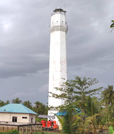
Date unknown. Active; focal plane 48 m (157 ft); two white flashes every 8 s. 15 m (49 ft) octagonal cylindrical concrete tower, painted white. The Coast Guard photo is at right and Google has a satellite view. NGA lists a skeletal tower. Located on the outermost of a group of small islands at the north edge of the Karimata Archipelago. Accessible only by boat. Site status unknown. Admiralty Q1407; NGA 25064.

Kabu Raya Regency Lighthouses
Pulau Masatiga
Date unknown. Active; focal plane 71 m (233 ft); two white flashes every 15 s. Approx. 15 m (49 ft) square white skeletal tower. No photo available but Bing has a satellite view. Located on a small island off the southwestern tip of Pulau Padangtikar. Accessible only by boat. Site status unknown. Admiralty Q1403.5.
Tanjung Padangtikar (Padang Tikar)
Date unknown. Active; focal plane 15 m (49 ft); white flash every 3 s. 15 m (49 ft) round barbell-shaped white fiberglass tower mounted on a platform supported by piles. Herman Lauw has a distant view from the shoreline and Google has an indistinct satellite view. The range guides vessels into the Padangtikar River estuary leading to the port of Batu Ampar. Located on the south side of the river mouth and just off the northwestern tip of Pulau Padangtikar. Accessible only by boat. Site open, tower closed. Admiralty Q1402; NGA 25068.

Pulau Lemanbudi Light, Karimata Strait
Indonesian Coast Guard Pontianak Navigation Region photo
Telokayer
Date unknown. Active; focal plane 10 m (33 ft); three white flashes every 15 s. Approx. 9 m (30 ft) square white skeletal tower. No photo available but Bing has a distant satellite view. This light serves as a leading light for ships in the Padangtikar River and marks a fork in the river system. The Admiralty calls the light "Tanjung Nibung West Side" but it is not near Tanjung Nibung. Located on a forested point across the river from Batu Ampar. Accessible only by boat. Site status unknown. Admiraly Q1405.
Tanjung Putus
Date unknown. Active; focal plane 15 m (49 ft); three white flashes every 15 s. 12 m (39 ft) square white skeletal tower. No photo available but Bing has a satellite view. Located in a low area north of the mouth of the Kapuas River. Site status unknown. Admiralty Q1400; NGA 25068.7.

Pontianak Regency Lighthouses
Pontianak is the capital of West Kalimantan and the largest city of the west coast of Kalimantan with a population of about 675,000. The city is located on the Equator in the delta of the Kapuas River, Indonesia's longest river.

* Tanjung Intan
Date unknown. Active; focal plane about 33 m (108 ft); white light, pattern unknown. Approx. 30 m (98 ft) octagonal white concrete tower with lantern and gallery. Two coast guard buildings. Yulia Chang's 2022 photo is at right, Helo Soleh has a 2023 photo, and Google has a satellite view. Apparently intended as aa landfall light for Pontianak. Located on the south side of the estuary entrance. Accessible by road. Site open, tower closed. Admiralty F1872.25.

Tanjung Intan Light, Pontianak, June 2022
Google Maps photo by Yulia Chang
Sungai Kapuas Kecil (Pontianak) Range Front
Date unknown. Active; focal plane 16 m (52 ft); quick-flashing white light. 15 m (49 ft) square skeletal tower mounted on a platform supported by piles. No photo available but Bing has an indistinct satellite view. The range guides vessels into the Little Kapuas River estuary leading to Pontianak. The rear light is on a smaller tower on a hillside onshore. Located on the north side of the river mouth. Accessible only by boat. Site open, tower closed. Admiralty F1872; NGA 25072.
Sungai Kapuas Kecil (Pontianak) Range Rear
Date unknown. Active; focal plane 25 m (82 ft); white light, 2 s on, 2 s off. Approx. 17 m (56 ft) square skeletal tower carrying a red triangular daymark. Noor Fatiha's 2022 photo is at right and he or she also has a video taken atop the tower. Google has a distant satellite view. NGA lists the light as 26 ft (8 m) tall, probably a typo. Located onshore 1720 m (1.07 mi) east southeast of the front light. Site appears open, and the tower can be climbed. Admiralty F1872.1; NGA 25076.
Jungkat
Date unknown. Active; focal plane 12 m (39 ft); red flash every 4 s. 12 m (39 ft) square red skeletal tower mounted on a platform supported by piles. No photo available but Google has a satellite view. Located just off the north bank of the Little Kapuas River estuary introducing a series of industrial terminals. Accessible only by boat. Site open, tower closed. Admiralty F1872.3; NGA 25077.
Pulau Baharu
Date unknown. Active; focal plane 14 m (46 ft); green flash every 15 s. Approx. 15 m (49 ft) square skeletal tower mounted on a platform supported by piles. No photo available but Google has a satellite view. Located just off the south bank of the Little Kapuas River estuary. Accessible only by boat. Site open, tower closed. Admiralty F1872.45.
Pontianak Pertamina Jetty
Date unknown. Active; focal plane 15 m (49 ft); four white flashes every 8 s. Approx. 15 m (49 ft) square skeletal tower mounted on a platform supported by piles. No photo available but Google has an indistinct satellite view. Located beside the pier at the Pertamina oil terminal on the north side of the river in Pontianak. Site and tower closed. Admiralty F1873.2; NGA 25079.
Pulau Datu (Dato)
Date unknown. Active; focal plane 62 m (203 ft); three white flashes every 9 s. 30 m (98 ft) white skeletal tower. No photo available but Google has an indistinct satellite view. Located on an uninhabited island about 65 km (40 mi) west northwest of the Kapuas River mouth. Accessible only by boat. Site status unknown. Admiralty F1879; NGA 25081.

Sungai Kapuas Kecil Range Rear Light, Pontianak, June 2022
Google Maps photo by Noor Fatiha
* [Tanjung Bangkai]
Date unknown. Active; focal plane 18 m (59 ft); white flash every 5 s . Approx. 15 m (49 ft) mast. A photo is available and Google has a satellite view. Located at a small port just inside the mouth of the Mempawah River a shirt distance southeast of Tanjung Bangkai. Site ope, tower closed. Admiralty F1884.
Pulau Sitinjan (Sitijan) (2?)
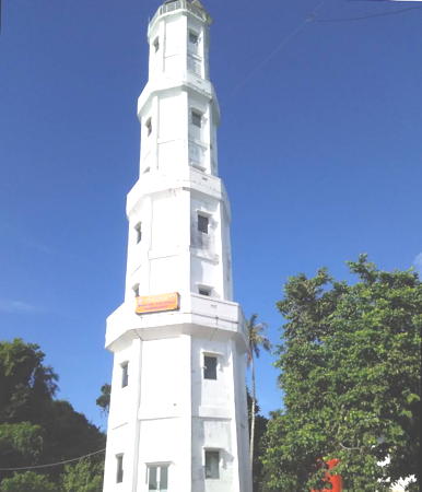
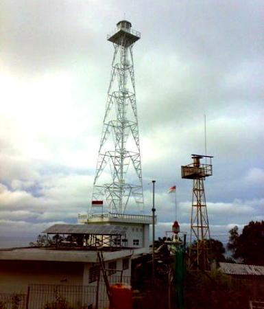
2018. Active; focal plane 90 m (295 ft); two white flashes every 15 s. Approx. 30 m (98 ft) 4-stage octagonal white concrete tower with lantern and gallery. Budi Ponty's photo is at the top of this page, Nanank Potlot has another photo, Ponty also has a photo of the tower under construction in 2017, and Bing has a satellite view. Google has a satellite view of the earlier light, a square skeletal tower with lantern and gallery. Located on an island about 75 km (45 mi) northwest of the Kapuas River mouth. Accessible only by boat. Site status unknown. Admiralty F1883; NGA 25082.
Pulau Lemukutan (Lemoekoetan)
Date unknown. Active; focal plane 314 m (1030 ft); three white flashes every 10 s. 19 m (59 ft) skeletal tower, painted white. No photo available but Google has a satellite view of the station. Pulau Lemukutan is a mountainous island about 18 km (12 mi) off the westernmost point of Kalimantan. Located on the highest point of the island. Accessible only by boat. Site status unknown. ARLHS IDO-214; Admiralty F1885; NGA 25084.

Sambas Regency Lighthouses
Tanjung Batu (Pemangkat)
Date unknown. Active; focal plane 11 m (36 ft); green flash every 3 s. 11 m (36 ft) tower. The tower is just off the point of land in Irwan Triputra's photo and the tower is hard to distinguish in Google's satellite view. Located at the tip of a promontory on the south side of the entrance to the Sambas River. Site status unknown. Admiralty F1890; NGA 25088.
Sungai Sambas Besar Range (Pemangkat Range) Front (2)
Date unknown. Active; focal plane 15 m (49 ft); white light, 1 s on, 1 s off. 15 m (49 ft) square skeletal tower mounted on a platform supported by piles. Tower painted with black and white horizontal bands. No photo available but Google has a satellite view. Nizar Kauzar has a very distant 2009 view of the earlier light. This is the entrance range for the Sambas River. Located in the river about 800 m (1/2 mi) northeast of Tanjung Batu. Accessible only by boat. Site open, tower closed. Admiralty F1892; NGA 25094.
Sungai Sambas Besar Range (Pemangkat Range) Rear
Date unknown. Active; focal plane 20 m (66 ft); white light, 2 s on, 2 s off. 20 m (66 ft) square skeletal tower mounted on a platform supported by piles. Tower painted with black and white horizontal bands. No photo available but Google has a satellite view. Located just off the south bank of the river 1148 m (0.71 mi) east of the front light. Accessible only by boat. Site open, tower closed. Admiralty F1892.1; NGA 25094.2.
Tanjung Parakan
Date unknown. Active; focal plane 13 m (43 ft); green flash every 5 s. 13 m (43 ft) tower on a square platform supporteed by piles. No photo available but Google has a satellite view. Located off a promontory on the south side of the Sambas River, about 800 m (1/2 mi) northwest of the Pemangkat ferry terminal. Accessible only by boat. Site open, tower closed. Admiralty F1892.6.
* Sintete Port
Date unknown. Active (?); focal plane 19 m (62 ft); white flash every 5 s. Approx. 12 m (39 ft) black skeletal tower; the front of the tower is covered by a slatted daymark. Ajie Arief has a 2014 closeup photo and Google has a satellite view. The tower has no light (yet?) in the 2014 photo. Located at a port on the south side of the Sambas River. Site ooen, tower closed. Admiralty F1892.9.
Bukit Kalangbau (Kalang Bahu, Sungai Sambas)
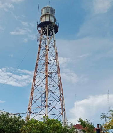
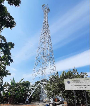
Date unknown. Active; focal plane 132 m (433 ft); two white flashes every 15 s. 40 m (131 ft) tapered square skeletal tower with lantern and gallery, painted white. Nanda Nurussalam has the 2021 photo seen at right, Bung Jang has a 2018 closeup photo, Yanto Wen also has a closeup, and Google has a satellite view of the station. NGA lists the station as Pulau Pekak, although it is not on an island. Located on a steep-sided hill on the north side of the entrance to the Sambas River opposite the port of Pemangkat. Site status unknown. Admiralty F1891; NGA 25092.

Bukit Kalangbau Light, Pemangkat, April 2021
Google Maps photo by Nanda Nurussalam
Tanjung Bayung
Date unknown. Active; focal plane 12 m (39 ft); red flash every 3 s. 12 m (39 ft) red tower, form unknown, presumably on a square platform supporteed by piles. No photo available and the light is not shown on Bing's satellite view. Located about 1.2 km (3/4 mi) off the coast about 32 km (20 mi) north of the Sungai Sambas entrance. Accessible only by boat. Site open, tower closed. Admiralty F1893.1.
Sungai Paloh
Date unknown. Active; focal plane about 15 m (49 ft); white light, pattern unknown. Approx. 15 m (49 ft) barbell-shaped white fiberglass tower mounted on a square platform supported by piles. No photo available but Bing has a satellite view. Located about 2.5 km (1.5 mi) off the mouth of the Paloh River, about 40 km (25 mi) southwest of Tanjung Datu. Accessible only by boat. Site open, tower closed. Admiralty F1893.15.
Tanjung Datu (1?)
1885(?). Inactive since 1978. 10 m (33 ft) square skeletal tower. The tower appears in the photo at right. It is claimed to be an original Dutch lighthouse, although that seems unlikely.
Tanjung Datu (2?)
1978. Inactive since 2006. Approx. 5 m (16 ft) white concrete tower. The tower is partially hidden in the photo at right.
Tanjung Datu (3?)
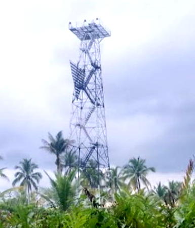
2006. Active; focal plane about 205 m (673 ft); two long (1.5 s) white flashes every 12 s. 40 m (131 ft) square skeletal tower with gallery, painted white, centered on a 2-story station building. Yus Ran has a photo, another photo is at right, and Google has a satellite view of the station. This staffed lighthouse marks the border between Indonesia and the Sarawak state of Malaysia. Since 1987 this border has been the site of dueling lighthouses, one on the Malaysian side and one on the Indonesian side. A photo near the top of the Directory's Sarawak page shows the Malaysian 8 m (26 ft) round cylindrical concrete tower (focal plane 171 m (561 ft; white flash every 15 s) as well as the original Indonesian light. A chain link fence separates the Indonesian light station from the Malaysian light. In 2014 Malaysia began construction of a new light on a platform off the point of the cape; construction was halted when Indonesia protested that the location was in Indonesian waters as provided by a 1969 treaty. Located on a promontory at the tip of the Datu Peninsula about 50 km (30 mi) northwest of Sematan, Malaysia. Site status unknown. Admiralty F1893.2.

Three lighthouses at Tanjung Datu, 2015
ex-Indonesian Ministry of Transportation photo

Information available on lost lighthouses:

Notable faux lighthouses:

Adjoining pages: North: Sarawak | East: Central Kalimantan | West: Belitung | Northwest: Natuna Sea Islands

Return to the Lighthouse Directory index | Ratings key

Posted December 9, 2008. Checked and revised June 6, 2024. Lighthouses: 40. Site copyright 2024 Russ Rowlett and the University of North Carolina at Chapel Hill.