Lighthouses of Indonesia: Northeastern Kalimantan (Borneo)

The Republic of Indonesia has been independent since 1945 after having been the Dutch East Indies for more than 350 years. It is a huge country, stretching along both sides of the Equator for more than 46 degrees of longitude (roughly 5100 km or 3200 miles). Comprised of some 17,000 islands (more than 6000 inhabited islands), it has hundreds of major aids to navigation.

Borneo, known as Kalimantan in Indonesia, is the world's third largest island; it is roughly 1335 km (835 mi) long northeast to southeast. 73% of the island is Indonesian; the remaining portion includes the Malaysian states of Sarawak and Sabah and the independent sultanate of Brunei. Indonesian Kalimantan is separated from Sulawesi (Celebes) to the east by the Makassar Strait, from Java to the south by the Java Sea, and from Sumatra to the southwest by the Karimata Strait and Natuna Sea.

Indonesia is divided into 38 provinces (provinsi) and the provinces are subdivided into county units called regencies (kabupaten). Kalimantan includes five of the provinces. This page describes lighthouses of the northeastern Kalimantan coast facing the Sulawesi (Celebes) Sea. This includes the coasts of North Kalimantan Province and also the Berau Regency in northernmost East Kalimantan Province. North Kalimantan was separated from East Kalimantan in 2012.

More than 700 languages are spoken in Indonesia. The official national language, Indonesian (Bahasa Indonesia), was standardized from a form of Malay that served as a lingua franca across the archipelago. In Indonesian a lighthouse is a mercusuar or a menara suar. Tanjung is a cape, ujung is a headland or point of land, bukit is a hill, sungai is a river, kuala or muara is an estuary or river mouth, pulau is an island, karang is a reef, batu is a rock, laut is a sea, selat is a strait, teluk is a bay, pelabuhan is a harbor, and labuhan is a port.

Aids to navigation in Indonesia are operated and maintained by the Directorate of Marine Navigation within the Directorate General of Sea Transportation

ARLHS numbers are from the ARLHS World List of Lights. Admiralty numbers are from volumes F and Q of the Admiralty List of Lights & Fog Signals. U.S. NGA List numbers are from Publication 112.

General Sources
Online List of Lights - Indonesia - Kalimantan - Celebes Sea
Photos by various photographers posted by Alexander Trabas.
Indonesian Lighthouses
Historic postcard views from the collection of Michel Forand.
World of Lighthouses - Indonesia
Photos by various photographers available from Lightphotos.net.
GPSNauticalCharts
Navigational chart information for eastern Kalimantan.
Kalimantan Timur Map
A useful map of eastern Kalimantan.
Navionics Charts
Navigation chart for eastern Kalimantan.

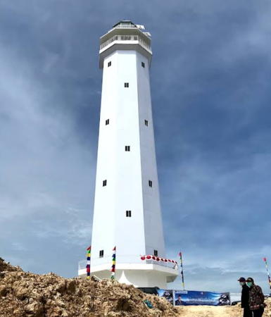
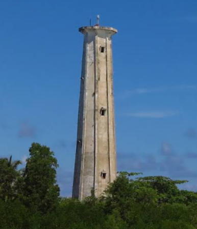
Mamburungan Light, Tarakan, April 2021
Google Maps photo by Darwis Ajalah

Kalimantan Utara (North Kalimantan) Province Lighthouses

Nunukan Regency Lighthouses
Pulau Sebatik (Sebatik Island)
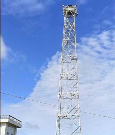
Date unknown. Active; focal plane 42 m (138 ft); two white flashes every 12 s. 40 m (131 ft) square skeletal tower with gallery. A 2019 photo is at right, Tio Kosasih has a 2017 photo, and Google has a satellite view. A 2-story Coast Guard station is beside the tower. The border between Malaysia and Indonesia bisects Sebatik Island. This lighthouse is very close to the Malaysian border, leading to some confusion: the NGA list and Bing Maps have the lighthouse in Malaysia while the Admiralty and Google Maps have it in Indonesia. It is clearly an Indonesian lighthouse. Located on the east coast of Sebatik. Site open, tower closed. Admiralty F1999.3; NGA 24731.
Pelabuhan Sebatik
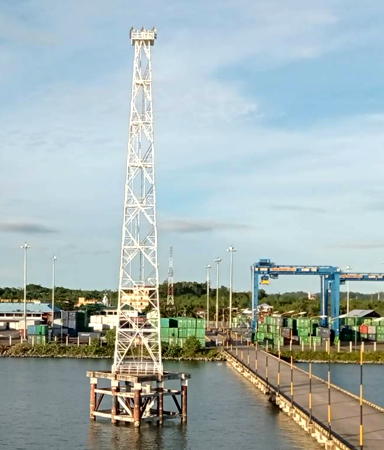
Date unknown. Active; focal plane about 30 m (98 ft); white light, pattern unknown. Apprx. 26 m (85 ft) square white skeletal tower on a platform supported by piles. Rikhsan Kurniatuhadi has a 2018 photo and Bing has a satellite view. Located beside a very long pier extending from Sebatik port. Accessible only by boat. Site open, tower closed. Admiralty F1999.33.
Pulau Sebatik West
Date unknown. Active; focal plane about 16 m (52 ft); light characteristic unknown. Approx. 16 m (52 ft) square skeletal tower mounted on a square platform supported by piles. No photo available but Google has a fuzzy satellite view. This light marks the international border on the west side of Sebatik Island. Located just offshore. Accessible only by boat. Site open, tower closed. Admiralty F1999.4.
Tanjung Harapan (Pulau Nunukan Timur)
Date unknown. Active; focal plane 15 m (49 ft); red flash every 5 s. 15 m (49 ft) skeletal tower mounted on a platform supported by piles. Entire lighthouse is red. No photo available but Google has a distant satellite view. The light guides vessels into the strait between Pulau Sebatik and Pulau Nunukan. Located just off the eastern tip of Pulau Nunukan. Accessible only by boat.Site open, tower closed. Admiralty F1999.6; NGA 24744.
Gosong Nunukan
Date unknown. Active; focal plane 14 m (46 ft); three quick white flashes every 10 s. 14 m (46 ft) beacon, painted black with a red horizontal band. No photo available and the light is not seen in Bing's satellite view. Located on a shoal about 25 km (15 mi) southeast of Pulau Nunukan. Accessible only by boat. Site open, tower closed. Admiralty F1999.65; NGA 24746.
Gosong Makasar (Makassar Bank)
Date unknown. Active; focal plane 15 m (49 ft); green flash every 3 s. 15 m (49 ft) beacon, painted green. No photo available and the light is not seen in Bing's satellite view. Located on the west end of a shoal about 15 km (9 mi) southeast of Pulau Sebatik, near the Malaysian border. Accessible only by boat. Site open, tower closed. Admiralty F1999.7; NGA 24745.

Pulau Sebatik Light, May 2019
Google Maps photo by DALMONCE
Gosong Makasar (Makassar Bank) Center
Date unknown. Active; focal plane 18 m (59 ft); white flash every 5 s. 18 m (59 ft) beacon, painted white. No photo available but Bing has a satellite view. Located on the center of the shoal about 2 km (1.25 mi) east of of teh west light (previous entry). Accessible only by boat. Site open, tower closed. Admiralty F1999.73; NGA 24745.5.
Karang Unarang (2)
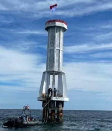
2017 (station established 2005). Active; focal plane 20 m (66 ft); white flash every 5 s. 20 m (66 ft) octagonal concrete tower with gallery standing on a platform supported by piles. The tower is white with a red band on the gallery. Ivan Syafi'i's October 2017 photo at right shows the just-completed lighthouse and Bambang Priyo Cahyono has a 2021 drone view but the light is not shown in Google's satellite view. Next to the new lighthouse is the platform of the former light, a 15 m (49 ft) square skeletal tower with gallery; Syafi has a photo showing both towers. This lighthouse is in the Ambalat Block, a section of the Celebes Sea in dispute between Indonesia and Malaysia; the area may contain important oil and gas deposits. Construction of the first lighthouse was interrupted in February 2005 when Malaysian naval forces arrested the construction workers (they were later released). Located on a reef, sometimes above water at low tide, about 20 km (13 mi) east of Pulau Sebatik, Indonesia, and 25 km (15 mi) south of the Malaysian coast. Accessible only by boat. Site and tower closed. Admiralty F1999.75; NGA 24744.5.
Karang Banda
Date unknown. Active; focal plane 18 m (59 ft); two white flashes every 12 s. 18 m (59 ft) beacon, painted black with a red horizontal band. No photo available and the light is not shown in Bing's satellite view. Located on a reef about 80 km (50 mi) southeast of Pulau Nunukan and 25 km (15 mi) east of Tanjung Ahus. Accessible only by boat. Site open, tower closed. Admiralty F1999.8; NGA 24747.
Pulau Ahus
Date unknown. Active; focal plane about 13 m (43 ft); red light, characteristic unknown. Approx. 13 m (43 ft) barbell-shaped red fiberglass tower mounted on a square platform supported by piles. No photo available but Bing has a satellite view. Located on a shoal off the north point of Pulau Ahus, an island south of Pulau Nunakan. Accessible only by boat. Site open, tower closed. Admiralty F1999.68.
Tanjung Ahus
Date unknown. Active; focal plane 15 m (49 ft); three quick white flashes every 10 s. 15 m (49 ft) beacon, painted black with a red horizontal band and mounted on a square pier supported by piles. No photo available but Bing has a satellite view. Located on a shoal about 15 km (9 mi) southeast of Tanjung Ahus. Accessible only by boat. Site open, tower closed. Admiralty F1999.9; NGA 24749.

Karang Unarang Light, Ambalat Block, October 2017
Google Maps photo by Ivan Syafi'i

Northern Bulungan Regency Lighthouses
Gosong Bunyu (Pulau Bunyu)
Date unknown. Active; focal plane 18 m (59 ft); white flash every 6 s. 18 m (59 ft) white tower mounted on a square platform. No photo available but the light is not shown in Bing's satellite view. Located on a shoal off the east coast of Pulau Bunyu, a large island about 35 km (22 mi) northeast of Tarakan. Accessible only by boat. Site open, tower closed. Admiralty F2000; NGA 24752.
Tanjung Arang
Date unknown. Active; focal plane 47 m (154 ft); white flash every 5 s. White skeletal tower; NGA does not list the height but the tower appears to be at least 20 m (66 ft) tall. No photo available but Google has a distant satellite view. Located atop a bluff near the southern tip of Pulau Bunyu. Site open, tower closed. Admiralty F2000.5; NGA 24753.
Tanjung Tibi
Date unknown. Active; focal plane 13 m (43 ft); white flash every 7 s. 13 m (43 ft) "white beacon," most likely a square skeletal tower on a platform supported by piles. No photo available and the light is not shown in Google's satellite view. Located at the end of a long shoal extending from Pulau Tibi, about 6.5 km (4 mi) northeast of Pulau Tarakan. Accessible only by boat. Site open, tower closed. Admiralty F2001; NGA 24754.

Tarakan City (Pulau Tarakan) Lighthouses
Tarakan, the only large city of Kalimantan Utara, has a population of about 250,000. The city occupies all of Pulau Tarakan, a large, shield-shaped island just off the mainland coast. The downtown and the port area are located on the west side of an island. Lingkas is the port district of the city but the port is called Pelabuhan Malundung.

Tanjung Batu
Date unknown. Active; focal plane 13 m (43 ft); green flash every 5 s. 13 m (43 ft) square green skeletal tower on a platform supported by piles. A distant street view from the Mamburungan lighthouse (next entry) is available and Google has a satellite view. Located about 800 m (1/2 mi) southeast of the southern tip of Tarakan Island. Site open, tower closed. Admiralty F2009; NGA 24762.
* Mamburungan (Tanjung Batu)
2021. Active(?); focal plane about 60 m (197 ft); light charactistics unknonwn. 43 m (141 ft) octagonal white concrete tower. Darwis Ajalah has the closeup photo at the top of this page, Kuspriyanto Abednego has a 2022 photo, a closeup street view is available, and Google has a satellite view. This project suffered a severe setback in December 2020 when a foundation failure caused the tower to begin leaning. Somehow this problem was overcome and the lighthouse was declared complete in April 2021. This lighthouse would be a landfall light for Tarakan. Located at the village of Mamburungan on the southern tip of Tarakan Island. Site status unknown. Not listed by the Admiralty.
Gosong Melulun (Lingkas Approach) Range Front
Date unknown. Active; focal plane 14 m (46 ft); quick-flashing red light. 14 m (46 ft) square skeletal tower, painted red and mounted on a square platform supported by piles. No photo available but Google has a satellite view. The range guides vessels past shoals off the southern tip of Pulau Tarakan. Accessible only by boat. Site open, tower closed. Admiralty F2008; NGA 24764.
Gosong Melulun (Lingkas Approach) Range Rear
Date unknown. Active; focal plane 19 m (62 ft); white flash every 5 s. 19 m (62 ft) square white skeletal tower mounted on a square platform supported by piles. No photo available but Google has a satellite view. Located 914 m (0.57 mi) west of the front light. Accessible only by boat. Site open, tower closed. Admiralty F2008.1; NGA 24768.
Tanjung Mengacu
Date unknown. Active; focal plane 14 m (46 ft); green flash every 5 s. 14 m (46 ft) square green skeletal tower mounted on a square platform supported by piles. The light is at the left in Allan Ticoalu's distant view from shore and Google has a distant satellite view. Located at the northern edge of the deep water channel off Mamburungan, opposite the Gosong Melulun Rear light. Accessible only by boat. Site open, tower closed. Admiralty F2010; NGA 24772.
* Lingkas (2)
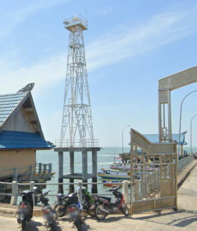
2010 (?). Active; focal plane about 40 m (131 ft) (?); white flash every 10 s. Approx. 40 m (131 ft) square pyramidal skeletal tower, painted white and mounted on a square platform supported by piles. A photo is at right, Anwari Eka Putra has a photo, Yen Nguyen has a night time photo, and Google has a satellite view. The Admiralty formerly listed a 10 m (33 ft) tower. Located in the harbor of Lingkas, on the south side of Pulau Tarakan. Accessible only by boat but easily visible from shore. Admiralty F2010.05.
Pulau Sadau
Date unknown. Active; focal plane 19 m (62 ft); white flash every 5 s. 19 m (62 ft) square white skeletal tower mounted on a square platform supported by piles. A distant view from shore is available and Google has a satellite view. Located at the junction of two straits about 8 km (5 mi) northwest of the Tarakan waterfront. Accessible only by boat. Site open, tower closed. Admiralty F2010.15.

Lingkas Light, Tarakan, March 2021
Google Maps photo by 3 Bidadari

Southern Bulungan Regency Lighthouses
Tanjung Keris
Date unknown. Active; focal plane 15 m (49 ft); red flash every 6 s. 15 m (49 ft) "red beacon," most likely a square skeletal tower on a platform supported by piles. No photo available and the light is not shown in Google's satellite view. Located about 2.5 km (1.5 mi) southeast of Tanjung Keris and 5 km (3 mi) southwest of the Tarakan waterfront. Accessible only by boat. Site open, tower closed. Admiralty F2010.2; NGA 24771.
Salin Batu
Date unknown. Active; focal plane about 13 m (43 ft); red light, pattern unknown. Approx. 13 m (43 ft) red barbell-shaped tower on a platform supported by piles. No photo available but Bing has a satellite view. Located on a shoal on the approach to the Salin Batu estuary about 25 km (15 mi) southwest of Tarakan. Accessible only by boat. Site open, tower closed. Admiralty F2007; NGA 24770.
Muara Salin Batu (Salin Batu Estuary)
Date unknown. Active; focal plane about 13 m (43 ft); green light, pattern unknown. No photo available but the shadow seen in Bing's indistinct satellite view suggests this is a green barbell-shaped tower on a platform supported by piles. Located on a shoal in the entrance to the Salin Batu estuary. Accessible only by boat. Site open, tower closed. Admiralty F2006.
Makapan
Date unknown. Active; focal plane 14 m (46 ft); white flash every 6 s. 14 m (46 ft) beacon, no description given, and the light is not shown in Google's satelllite view. This light marks the east edge of extensive shoals off the delta of the Bulungan River south of Tarakan. Located about 25 km (15 mi) offshore. Accessible only by boat. Site open, tower closed. Admiralty F2014.3; NGA 24772.5.
Karang Baliktaba
Date unknown. Active; focal plane 14 m (46 ft); white flash every 8 s. 14 m (46 ft) square white skeletal tower mounted on a square platform supported by piles. No photo available but Bing has a satellite view. Located on a shoal about 15 km (9 mi) off Kelapa Beach near the southern border of Kalimantan Utara. Accessible only by boat. Site open, tower closed. Admiralty F2014.5; NGA 24773.1.

Kalimantan Timur (East Kalimantan) Province: Berau Regency Lighthouses

Berau Regency includes the coast between two prominent capes, Tanjung Batu and Tanjung Mangkalihat. Between the two capes the low-lying delta of the Berau River is covered by a tropical rainforest. Offshore are two lines of reefs aligned northwest to southeast parallel to the coast.

Mainland Coast Lighthouses
* Tanjung Batu
Date unknown (recent). Active; focal plane about 18 m (59 ft); white light, pattern unknown. Approx. 15 m (49 ft) square pyramidal skeletal tower, painted white, mounted on a square platform supported by piles. A photo is available and Google has a street view (also seen at right) and a satellite view. Note: Tanjung Batu (Rocky Cape) is a common place name in Indonesia and Malaysia. Located beside the pier at Tanjung Batu, a port on the mainland near the northern border of Kalimantan Timur. Site open, tower closed. Not listed by the Admiralty.
Karang Tanjung Balalang
Date unknown. Active; focal plane unknown; white light, pattern unknown. Tower on a platform supported by piles. No photo available but Bing's fuzzy satellite view locates the platform. Located at the north end of a large shoal area about 3 km (1.8 mi) south of the Tanjung Batu waterfront. Accessible only by boat. Site open, tower closed. Admiralty F2017.
Haji Bank East
Date unknown. Active; focal plane about 12 m (39 ft); white light, pattern unknown. Approx. 12 m (39 ft) white square skeletal tower on a platform supported by piles. A distant street view is available (this light is on the left) and Google has a satellite view. Located at the east end of a long shoal in the Berau River at Samburakat. Accessible only by boat. Site open, tower closed. Admiralty F2024.1.
Haji Bank West
Date unknown. Active; focal plane about 12 m (39 ft); white light, pattern unknown. Approx. 12 m (39 ft) white square skeletal tower on a platform supported by piles. A distant street view is available (this light is on the right) and Google has a satellite view. Located at the west end of a long shoal in the Berau River, about 1 km (0.6 mi) west of the east light. Accessible only by boat. Site open, tower closed. Admiralty F2024.15.

Tanjung Batu Light, Tanjung Batu, June 2016
Google Maps street view
Muara Pantai North (1 and 2)
Date unknown. Active; focal plane 13 m (43 ft); green flash every 3 s. 13 m (43 ft) square green skeletal tower on a platform supported by piles. No photo available. Bing's indistinct satellite view shows two towers; probably the active light is the one on the left (west). The Pantai (Beach) Estuary is the southernmost distributary of the Berau River and the principal entrance for navigation. Located just offshore on the north side of the entrance. Accessible only by boat. Site open, tower closed. Admiralty F2024.3; NGA 24778.
Muara Pantai South
Date unknown. Active; focal plane 13 m (43 ft); white flash every 7 s. 13 m (43 ft) square white skeletal tower on a platform supported by piles. No photo available but Bing has a satellite view. Located offshore on the south side of the estuary entrance. Accessible only by boat. Site open, tower closed. Admiralty F2024.2; NGA 24779.
Karang Besar
Date unknown. Active; focal plane 13 m (43 ft); white flash every 9 s. 13 m (43 ft) square white skeletal tower on a platform supported by piles. No photo available but Bing has a satellite view. This light marks a gap in reefs close offshore about halfway between Muara Pantai and Tanjung Mangkalihat. Located at the south end of the reef. Accessible only by boat. Site open, tower closed. Admiralty F2022.5; NGA 24786.

Inner (Derawan) Reef Lighthouses
Pulau Panjang
Date unknown. Active; focal plane 14 m (46 ft); white flash every 5 s. Approx. 12 m (39 ft) square white skeletal tower. No photo available but Bing has an indistinct satellite view. Located on the north end of Pulau Panjang, the northernmost island of the Derawan reef complex about 40 km (25 mi) northeast of Tanjung Batu. Site status unknown. Admiralty F2015.5; NGA 24773.
Karang Derawan (2)
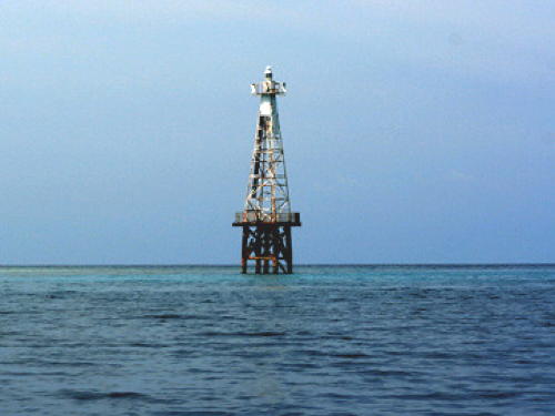
Date unknown. Active; focal plane about 30 m (98 ft); white flash every 10 s. Approx. 30 m (98 ft) square pyramidal skeletal tower, painted white, mounted on a square platform supported by piles. A photo is at right and Google has a distant satellite view. NGA lists a much smaller tower. This light marks a narrow pass through the reef system. Located on a reef about 30 km (19 mi) east of Tanjung Redeb. Accessible only by boat. Site open, tower closed. ARLHS IDO-142; Admiralty F2015.7; NGA 24775.
Karang Tidung
Date unknown. Active; focal plane 14 m (46 ft); two white flashes every 10 s. 14 m (46 ft) tower (form unknown) mounted on a square platform supported by piles. Tower painted black with one red horizontal band. No photo available and the tower has not been found in Bing's satellite view. Located on an isolated shoal midway between the mainland and the Derawan reef complex. Accessible only by boat. Site open, tower closed. Admiralty F2016.5; NGA 24775.1.
Pulau Sangalakki (1 and 2)
Date unknown. Active; focal plane 15 m (49 ft); white flash every 3 s. 15 m (49 ft) square white skeletal tower mounted on a square platform supported by piles. A distant 2022 view from shore is available, oungjin Song has a very distant view (showing two towers, with zoom), and the lighthouse is barely visible at the left end of the island in Aganto Seno's photo, but the light is not shown in Bing's satellite view. This light and the next one mark the ends of a wide passage through the reefs. Located just off an islet about 50 km (30 mi) west of Pulau Bakungan. Accessible only by boat. Site open, tower closed. Admiralty F2016; NGA 24776.
Karang Derawan
Karang Derawan Light, Celebes Sea, October 2007
Flickr Creative Commons photo by Degi
Karang Malalungan (1 and 2)
Date unknown. Active; focal plane about 30 m (98 ft); white flash every 10 s. Approx. 30 m (98 ft) square pyramidal skeletal tower, painted white, mounted on a square platform supported by piles. No photo currently available but Bing has a distant satellite view. NGA lists the older, smaller tower. Located on a reef about 20 km (13 mi) south of Pulau Sangalakki. Accessible only by boat. Site open, tower closed. Admiralty F2018; NGA 24780.

Outer (Maratua/Muaras) Reef Lighthouses
The outer reef system consists of two elongated atolls known as the Maratua and Muaras Reefs. The Maratua Reef is about 25 km (15 mi) long. The Muaras Reef, mostly awash at high tide, is about 30 km (19 mi) long. There is a gap of about 15 km (9 mi) between the two atolls.

Tanjung Bolituwatan (Pulau Maratua)
Date unknown. Active; focal plane 55 m (180 ft); white flash every 15 s. Approx. 45 m (148 ft) square skeletal tower with lantern and gallery, painted white; lantern painted red. Several blue-roofed coast guard buildings. Ervan Muliyadi has a closeup photo, a distant view is available, and Google has a satellite view of the station. Located at the northern tip of Pulau Maratua, a large reef complex in the Celebes Sea about 50 km (30 mi) east of Tanjung Batu. Accessible only by boat. Maratua is a popular scuba diving location; a diving map shows the location of the lighthouse. Site open, tower closed. Admiralty F2015; NGA 24774.
Pulau Bakungan
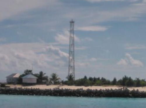
Date unknown. Active; focal plane 35 m (115 ft); white flash every 10 s. 30 m (98 ft) octagonal white concrete tower. 1-story keeper's house. Sayf al Hakam has a photo (a portion is seen at right), another photo is available, Daniel Wickers has a view from the sea, a small photo is available, Franz Till has a street view, and Bing has a satellite view of the station. The Virgin Cocoa resort is adjacent to the lighthouse. Located at the southeastern tip of the Maratua Reef complex. Accessible only by boat. Site open, tower closed. ARLHS IDO-103; Admiralty F2019; NGA 24775.5.

Pulau Bakungan Light, Maratua Reef, May 2015
Google Maps photo by Sayf al Hakam
Karang Gosongan
Date unknown. Active; focal plane 13 m (43 ft); three white flashes every 20 s. 13 m (43 ft) square white skeletal tower mounted on a square platform supported by piles. No photo available and the light has not been found in Bing's satellite view. NGA spells the name Gonsungan. Located at the northwest end of the Muaras Reef complex. Accessible only by boat. Site open, tower closed. Admiralty F2020; NGA 24782.
Pulau Sambit (Karang Muaras, Muaras Reef) (3)
Around 2015 (station established 1911). Active; focal plane 43 m (141 ft); white flash every 5 s. Approx. 40 m (131 ft) square skeletal tower with lantern and gallery. Two 1-story coast guard buildings. Tower painted white, lantern and gallery red. Habel Tandi has the 2018 photo at right and Google has a satellite. view. Abdurrahman Azhary has a 2010 photo of the second lighthouse and Bing has a satellite view. Pulau Sambit is a small island in the Celebes Sea about 80 km (50 mi) northeast of Sepinang; it occupies the extreme southeastern corner of the Muaras Reef atoll. The light guides ships approaching the Makassar Strait on the east side of Borneo. The old tower may have been removed because it ws threatened by beach erosion. Accessible only by boat. Site open, tower closed. ARLHS IDO-032; Admiralty F2022; NGA 24784.
Pulau Bilangbilangan (Bilang Bilangan)
Date unknown. Active; focal plane 13 m (43 ft); white flash every 10 s. 13 m (43 ft) "white beacon," apparently a post with gallery, mounted on a square platform supported by piles. No photo available but Google has a distant satellite view. Located at the end of a long reef extending from the mainland west of Pulau Sambit. Accessible only by boat. Site open, tower closed. Admiralty F2022.3; NGA 24787.

Pulau Sambit Light, Celebes Sea, February 2018
Google Maps photo by Habel Tandi
 

Information available on lost lighthouses:

Notable faux lighthouses:

Adjoining pages: North: Malaysia: Labuan and Sabah | South: Eastern Kalimantan

Return to the Lighthouse Directory index | Ratings key

Posted December 9, 2008. Checked and revised May 1, 2024. Lighthouses: 42. Site copyright 2024 Russ Rowlett and the University of North Carolina at Chapel Hill.