Lighthouses of Indonesia: Sumbawa

The Republic of Indonesia has been independent since 1945, after having been the Dutch East Indies for more than 350 years. It is a huge country, stretching along both sides of the Equator for more than 46 degrees of longitude (roughly 5100 km or 3200 miles). Comprised of some 17,000 islands (more than 6000 inhabited islands), it has hundreds of major aids to navigation.

The island arc that begins in the west with the major islands of Sumatra and Java continues eastward through a chain of smaller islands known in English as the Lesser Sunda Islands and in Indonesian as the Nusa Tenggara ("Southeastern Islands"). From west to east, the major Lesser Sunda Islands are Bali, Lombok, Sumbawa, Sumba, Flores, and Timor.

Indonesia is divided into 38 provinces (provinsi) and the provinces are subdivided into county units called regencies (kabupaten). This page includes lighthouses of Sumbawa, an island united with Lombok as West Nusa Tenggara (Nusa Tenggara Barat) Province. Sumbawa is about 240 km (150 mi) long and very mountainous in terrain and irregular in shape. It is separated from Lombok to the west by the Alas Strait. Teluk Saleh, a large embayment on the north coast, nearly cuts the island in half. On the east the Sape Strait separates Sumbawa from the smaller island of Komodo (famous for its giant lizards) and the much larger island of Flores. The population of Sumbawa is about 1.6 million.

More than 700 languages are spoken in Indonesia. The official national language, Indonesian (Bahasa Indonesia), was standardized from a form of Malay that served as a lingua franca across the archipelago. In Indonesian a lighthouse is a mercusuar or a menara suar. Tanjung is a cape, ujung is a headland or point of land, bukit is a hill, sungai is a river, kuala or muara is an estuary or river mouth, pulau is an island, karang is a reef, batu is a rock, laut is a sea, selat is a strait, teluk is a bay, pelabuhan is a harbor, and labuhan is a port. It's also worth knowing that the word for an island is nusa in Balinese and gili in the Sasak language spoken on Lombok and in western Sumbawa.

Aids to navigation in Indonesia are operated and maintained by the Directorate of Marine Navigation within the Directorate General of Sea Transportation.

ARLHS numbers are from the ARLHS World List of Lights. DSI numbers are Indonesian light list numbers as listed by the Benoa Navigation District. Admiralty numbers are from volume Q of the Admiralty List of Lights & Fog Signals. U.S. NGA List numbers are from Publication 112.

General Sources
Online List of Lights - Indonesia
Photos by various photographers posted by Alexander Trabas.
Sarana Bantu Navigasi-Pelayaran
From the Benoa Navigation District, photos and data on navigational aids. Based in Benoa, Bali, the district includes the islands of Bali, Lombok, and Sumbawa.
World of Lighthouses - Indonesia
Photos by various photgraphers available from Lightphotos.net.
Navionics Charts
Navigation chart for Sumbawa.

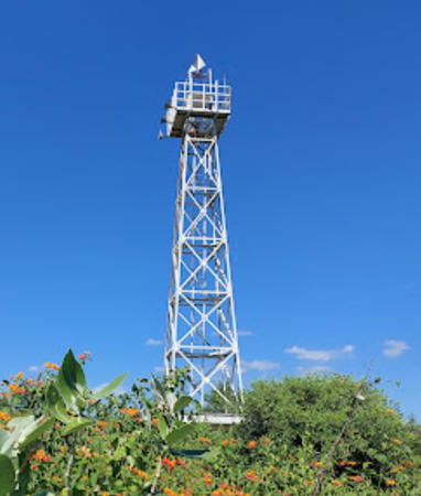
Tanjung Batu Besar Light, Bima Regency, Sumbawa, May 2020
Google Maps photo by Izy Alshuja
Sumbawa Barat (West Sumbawa) Regency (Alas Strait East Side) Lighthouses
Tanjung Talonan
2014. Active; focal plane 30 m (98 ft); white flash every 3 s. 15 m (49 ft) 2-stage tower, including a square white skeletal tower mounted atop a white concrete tower. A photo is at right and Google has a satellite view. Located on heights of the southwest coast of Sumbawa, about 25 km (15 mi) east southeast of Tanjung Mangkun. Site status unknown; this is a very remote area. DSI-4225; Admiralty Q1299.4.
Tanjung Mangkun (2)
2013 (station established 1994). Active; focal plane listed as 29 m (95 ft); white flash every 5 s. 15 m (49 ft) 2-stage tower, including a square white skeletal tower mounted atop a white concrete tower. A distant 2021 view reveals that the focal plane is more likely to be 95 m (311 ft). Google has an indistinct satellite view. Located at the tip of the very steep promontory at the extreme southwestern tip of Sumbawa. Site status unknown. DSi-4220; Admiralty Q1299.5; NGA 25569.
Tanjung Maloh (Benete Point)
Date unknown. Active; focal plane 126 m (413 ft); white flash every 7 s. Approx. 40 m (131 ft) square white skeletal tower. Several station buildings. No photo available but Google has a satellite view of the station. Located on a high promontory near the southwestern tip of Sumbawa, marking the southern entrance to the Alas Strait. Site status unknown; there is an unpaved road to the station. Admiralty Q1299.56; NGA 25572.7.
Port Benete Range Front
Date unknown. Active; focal plane 13 m (43 ft); quick-flashing white light. 13 m (43 ft) round white post carrying a red triangular daymark and mounted on a square 1-story stone base. Sugawonos Animarbeimar has a photo and Google has a satellite view. Benete is the terminal for fast ferries from Kayangan, East Lombok; the port also serves area mines. The rear light is on a shorter tower on the slope about 200 m (220 yd) east southeast. Located just offshore in Benete Bay. Admiralty Q1299.57; NGA 25572.8.
* Labuhan Lalar
Date unknown. Active (?); focal plane unknown; white light, pattern unknown. Approx. 12 m (39 ft) square white skeletal tower. Andy Jones has a sunset view and Google has a street view and a satellite view. Located beside the coastal highway on the north side of Lalar, a village on the central west coast of Sumbawa. Not listed by the Admiralty.
 

Tanjung Talonan Light, Sumbawa Barat, 2018
Benoa Navigation District photo
 
Pulau Paserang (2)
2015 (?). Active; focal plane 20 m (66 ft); white flash every 5 s. 15 m (49 ft) 2-stage tower, including a square white skeletal tower mounted atop a white concrete tower. The current light is not shown in Google's satellite view. The original light was offshore; that light is still listed by the Admiralty, the Benoa Navigation District still has the location of the offshore light, and Google's satellite view shows the offshore light. We need better information! Paserang is a small island in the northern Alas Strait. The location of the new light is not known. DSI-4216.1; Admiralty Q1305.5.
Pulau Ular
1995. Active; focal plane 49 m (161 ft); quick-flashing white light. 12 m (39 ft) square skeletal tower with gallery, uppermost section enclosed. Lighthouse painted with black and red horizontal bands. Simon Potter's photo is at right, Lightphotos.net has a view from the sea, Ririn Ambar has another view, and Google has a satellite view. Located on a small island off the northwestern coast of Sumbawa, marking the northern entrance to the Alas Strait. Accessible only by boat. Site status unknown, but there's a good view from ferries crossing the strait. ARLHS IDO-358; DSI-4215; Admiralty Q1305; NGA 25574.
Tanjung Tano (Photo Tano)
1994. Active; focal plane 14 m (46 ft); green flash every 3 s. 13 m (43 ft) round metal tower rising from a square 1-story equipment room. Tower painted green, equipment room white. A closeup photo is available, Yudha Sunandar has a view from the sea, and Google has a satellite view. Poto Tano, in the lee of Tanjung Tano, is the terminal for ferries arriving from Labuhan Lombok. Located on a sharp promontory on the northwestern coast of Sumbawa. Site status unknown, but there's a good view from ferries crossing the strait. DSI-4216; Admiralty Q1306; NGA 25574.4.

Pulau Ular Light, Alas Strait, June 2010
ex-Panoramio photo copyright Simon Potter; used by permission

Sumbawa Regency North Coast Lighthouses
The Sumbawa Regency is quite large; it includes 43% of the island and has lengthy coasts on both the north and south coasts of the island. Lights on the south coast are at the end of this page.

* Badas (2)
2015 (station established 1982). Active; focal plane 18 m (59 ft); white flash every 2 s. 15 m (49 ft) 2-stage square white concrete tower, lower portion octagonal and upper portion square skeletal. A photo of the light in action is available, Ahmad Julio has a distant view, and Google has a satellite view and a distant street view. Located on the quay on the west side of the entrance to Badas, a seaport in Sumbawa Bay about 3 km (2 mi) west of the traditional island capital of Sumbawa Besar. Site apparently open, tower closed. DSI-4230; Admiralty Q1308.
Badas Entrance West
1998. Active; focal plane 13 m (43 ft); green flash every 3 s. 13 m (43 ft) square skeletal tower with gallery, painted green, mounted on a square platform supported by piles. Agen Keripik Buah has a photo, Google has a street view and Bing has a satellite view. Located on a reef on the east side of the entrance to Badas. Accessible only by boat. Site open, tower closed. DSI-4229; Q1308.1; NGA 25603.
Badas Entrance East
2009. Active; focal plane 13 m (43 ft); red flash every 4 s. 13 m (43 ft) square skeletal tower with gallery, painted red, mounted on a square platform supported by piles. Agen Keripik Buah has a distant view, Google has a street view and Bing has a satellite view. Located on a reef on the east side of the entrance to Badas. Accessible only by boat. Site open, tower closed. DSI-4228; Admiralty Q1307.
Teluk Badas
Date unknown. Active; focal plane 10 m (33 ft); two white flashes every 5 s. 12 m (39 ft) square skeletal tower with gallery, enclosed on three sides by a white daymark, mounted on a triangular platform supported by piles. Google has a street view and a satellite view. The street view also shows a mast with a triangular daymark; this is the front beacon of an unlit entrance dayrange. Google has a street view of the rear beacon. Located in the estuary at Badas. Accessible only by boat. Site open, tower closed. Admiralty Q1307.3; NGA 25604.
Tanjung Menangis
Date unknown. Active (?); focal plane about 45 m (148 ft); light characteristic unknown. Approx. 22 m (72 ft) square skeletal tower with gallery, painted white. J. Maluw's photo is at right and Bing has a satellite view. The light guides vessels into the Saleh Strait, leading on the south side of Pulau Moyo into Saleh Bay. Located on a sharp promontory about 16 km (10 mi) north of Sumbawa Besar. Site status unknown. Not listed by the Admiralty and not charted by Navionics.
Tanjung Kolo
Date unknown. Active; focal plane 30 m (98 ft); yellow flash every 4 s. 30 m (98 ft) tower, form unknown. No photo available; the lighthouse is not visible in Google's satellite view. Located on or just off a headland on the southwest end of Pulau Moyo, a large island stretched across the entrance to Saleh Bay. Accessible only by boat. Site status unknown. Admiralty Q1304.4; NGA 25602.5.

Tanjung Menangis Light, Pulau Moyo, May 2023
Google Maps photo by J. Maluw
Pulau Medang
1970. Active; focal plane 50 m (164 ft); white flash every 5 s. 30 m (98 ft) square pyramidal skeletal tower with gallery, painted white. Several coast guard buildings. Nyoman Sutapa has a 2021 closeup photo, Made Sarjana has a 2022 photo, and Google has a satellite view. Pulau Medang is an island off the north coast of Sumbawa and northwest of Pulau Moyo, about 40 km (25 mi) north of the port of Sumbawa Besar. Located on the north coast of the island. Accessible only by boat. Site status unknown. ARLHS IDO-222; DSI-4210; Admiralty Q1304; NGA 25584.
Tanjung Srae (Tanjung Pasir)
2016. Active; focal plane 13 m (43 ft); white flash every 3 s. 13 m (43 ft) square white skeletal tower mounted on a square platform supported by piles. Google has a fuzzy satellite view. Located just off a headland at the northeastern corner of Pulau Moyo, marking the entrance to the Batahai Strait, which separates the island from the northern peninsula of Sumbawa. Accessible only by boat. Site open, tower closed. DSI-4213.2; Admiralty Q1308.3.
Tanjung Ai Lancong
Date unknown. Active; focal plane 14 m (46 ft); yellow flash every 3 s. 14 m (46 ft) yellow tower, presumably on a platform supported by piles. No photo available and the lighthouse is not visible in Google's satellite view. Located off a headland on the southeast coast of Pulau Moyo. Site status unknown. Admiralty Q1304.6; NGA 25602.7.

Dompu Regency North Coast Lighthouses
The north coast of Dompu Regency includes the east coast of Teluk Saleh (Saleh Bay), a long inlet that nearly separates Sumbawa into two parts. The bay is enclosed by the broad Sanggar Peninsula, dominated by the Tambora volcano. Tambora violently erupted in a series of eruptions in April 1815, ending with the largest eruption in recorded human history.

* Calabai (Tanjung Pekat)
2016. Active; focal plane 23 m (75 ft); white flash every 5 s. 20 m (66 ft) square white skeletal tower mounted on a square platform supported by piles. A photo is at right, Fēng Guó Jǐng has a photo, Eriko Utama has a street view, and Google has a satellite view. Located on the waterfront at Calabai, a small port on the east side of the entrance to Saleh Bay through the Batahai Strait. Accessible only by boat. Site open, tower closed. DSI-4213.1; Admiralty Q1308.2.
Tanjung Beranti
2016. Active; focal plane 23 m (75 ft); white flash every 3 s. 23 m (75 ft) square white skeletal tower mounted on a square platform supported by piles. No photo available but Google has a fuzzy satellite view. Located just off a headland about 3 km (2 mi) northeast of the entrance to the Batahai Strait. Accessible only by boat. Site open, tower closed. DSI-4213.3; Admiralty Q1308.35.
Pulau Satonda
2016. Active; focal plane 12 m (39 ft); white flash every 3 s. 12 m (39 ft) square white skeletal tower mounted on a square platform supported by piles. Google has a fuzzy satellite view. Satonda is a small island only 1.6 km (1 mi) off the north coast of Sumbawa. The island is a volcanic cone with a huge caldera that has been invaded by the sea; thus the island is shaped like a ring. Located at the edge of the reef on the southeast side of the island, marking the passage between the island and the mainland. Accessible only by boat. Site open, tower closed. DSI-4213.4; Admiralty Q1308.38.

Tanjung Pekat Light, Calabai, March 2020
Google Maps photo by Yudi Gpo

Bima Regency: Northwest Coast Lighthousesø
Bima Regency occupies the east end of Sumbawa. Relatively more populated than the other regencies it has about 33% of the population of the island.
Tanjung Pakijongan
1998. Active; focal plane 35 m (115 ft); white flash every 6 s. 30 m (98 ft) square pyramidal white skeletal tower with lantern and gallery. Google has a satellite view. Located at the northernmost point of Sumbawa and at the foot of Mount Tambora, a giant and dangerous volcano that exploded in 1815 in the largest volcanic eruption of modern history. Accessible only by boat, most likely. Site and tower closed. ARLHS IDO-361; DSI-4214; Admiralty Q1308.4; NGA 25602.
Tanjung Batu Besar (Batubesar)
1997. Active; focal plane 26 m (85 ft); white flash every 10 s. Approx. 21 m (69 ft) octagonal concrete tower with lantern and gallery. Entire lighthouse painted white. Izy Alshuja has the 2020 photo seen at the top of this page and Google has a closeup street view and a good satellite view. The name of the lighthouse means "Big Stone Cape." Located on a promontory on the north coast of Sumbawa, about 50 km (30 mi) northwest of Raba. Site status unknown. DSI-4238; Admiralty Q1308.5; NGA 25606.

Bima Regency: Bima Bay West Side Lighthouses
Bima Bay is a narrow inlet, about 40 km (25 mi) long and only 1-3 km (0.5-2 mi) wide, occupying a deep valley between the dormant Lambuwu and Maria volcanoes.

Tanjung Kotabaru (Benteng Utara)
Date unknown. Active; focal plane about 18 m (59 ft); green flashing light. Approx. 10 m (33 ft) square skeletal tower fully enclosed by metal panels. Entire lighthouse is green. Firman Herdiansah has a closeup photo and Bing has a satellite view. Located at the tip of sharp promontory projecting into the west side of lower Bima Bay. Site open, tower closed. Admiralty Q1310.6; NGA 25593.
Alur (Soembai)
1996. Active; focal plane 15 m (49 ft); green flash every 3 s. 15 m (49 ft) square skeletal tower, painted green and mounted on a square platform supported by piles. A photo is at right and Google has an indistinct satellite view. Located at the tip of a promontory on the west side of lower Bima Bay. Site open, tower closed. DSI-4240.6; Admiralty Q1310.2; NGA 25596.

Alur Light, Bima, 2018
Benoa Navigation District photo

Bima City (Bima Bay East Side) Lighthouses
Bima, the largest city of Sumbawa, has a population of about 150,000. The city is built on the east side of Bima Bay, a fjord-like inlet about 30 km (19 mi) long.
* Lawata (Wadumbolo)
Date unknown. Active; focal plane 10 m (33 ft); four white flashes every 8 s. 10 m (33 ft) square skeletal tower with gallery, painted white, mounted on a square concrete pier. Three sides of the tower are covered with white panels. Heru Supriyanto has a 2022 photo and Google has a closeup street view and a good satellite view. Located just off the beach at Lawata, a town on Bima Bay about 3 km (2 mi) south of Bima (see next entry). Site open, tower closed. Admiralty Q1309.5; NGA 25610.
* Bima (2)
2004 (station established 1982). Active; focal plane 33 m (108 ft); white flash every 6 s. Approx. 29 m (95 ft) square skeletal tower with gallery, painted white. Abi Royen has photo (a portion is at right), Reza Maha has a 2020 photo, Jimmy Geos has a view from the bay, and Google has a satellite view and a street view from the port entrance. NGA formerly listed a tower with a focal plane of 14 m (46 ft). Located on the main quay at Bima. Site open, tower closed. DSI-4240; Admiralty Q1310; NGA 25608.
Benteng Selatan
Date unknown. Active; focal plane about 15 m (49 ft); red flashing light. Approx. 10 m (33 ft) square skeletal tower fully enclosed by metal panels. Entire lighthouse is red. No photo available but Google has a satellite view. Located at the Bonto power plant on a promontory on the east side of lower Bima Bay. Site and tower closed. Admiralty Q1310.4; NGA 25594.
Tanjung Lampasapi (Lampa Sape)
1982. Active; focal plane 15 m (49 ft); red flash every 6 s. 15 m (49 ft) square skeletal tower fully enclosed by metal panels. Entire lighthouse is red. Digus Hanggariksa Putra has a view of the lighthouse and Google has a street view and an indistinct satellite view. Located just off the coastal highway at a promontory on the east side of lower Bima Bay, marking the entrance to the narrow portion of the bay. Accessible only by boat. Site open, tower closed. DSI-4241; Admiralty Q1309; NGA 25588.

Bima Light, Bima, December 2017
ex-Google Plus photo by Abi Royen

Bima Regency: East Coast (Sape Strait) Lighthouses
Pulau Sangeang (Sangeang Api) (2?)
1997. Active; focal plane 37 m (121 ft); white flash every 10 s. 30 m (98 ft) octagonal white concrete tower with lantern and gallery. Mike Gregory's photo is at right, Trabas has a fine photo by Thomas Philipp, Paul Koerber also has a view from the sea, and Google has a good satellite view. NGA lists this light as a "white beacon" with a focal plane of 21 m (69 ft). From the photos, it's clear that the focal plane of the present lighthouse is much higher and the tower itself is at least 25 m (82 ft) tall. Pulau Sangeang is a circular volcanic island about 15 km (9 mi) in diameter and about 10 km (6 mi) off the northeastern tip of Sumbawa. The volcano is one of the most vigorously active of all the Indonesian volcanos. Located on the northern tip of the island. Accessible only by boat. Site status unknown. DSI-4261.4; Admiralty Q1310.7; NGA 25613.
Tanjung Naru
1989. Active; focal plane 44 m (144 ft); two white flashes every 15 s. 40 m (131 ft) skeletal tower with lantern and gallery, painted white. Several coast guard station buildings. Nyoman Sutapa has a 2021 photo, Mike Dilan has a 2018 photo, and Google has a good satellite view. Located on the northeastern tip of Sumbawa opposite Pulau Sangeang. Site status unknown. DSI-4261; Admiralty Q1310.8; NGA 25614.
Tanjung Toronaganuri (Toro Naga Nuri)
2012. Active; focal plane 60 m (197 ft); white flash every 3 s. 15 m (49 ft) 2-stage tower, including a square skeletal tower mounted atop a white concrete tower. Google has a good satellite view. This lighthouse guides vessels into Bajo, Sumbawa's principal port on the Sape Strait at the eastern end of the island. Located on a promontory about 5 km (3 mi) north of Bajo. Site status unknown. DSI-4270; Admiralty Q1311; NGA 25616.

Pulau Sangeang Light, October 2007
Flickr photo copyright Mike P. Gregory; used by permission
Labuhan Sape (Nisa Sanai)
1996. Active; focal plane 14 m (46 ft); red flash every 4 s. Approx. 10 m (33 ft) round red fiberglass tower mounted on a square base. Josy Lukman has a 2023 photo and Bing has a distant satellite view. Located on Nisa Limbu, a small island off the north end of Nisa Sanai, an island sheltering the bay of Bajo. Accessible only by boat. Site open, tower closed. DSI-4262; Admiralty Q1311.2; NGA 25617.
* Bajo (Badjo, Teluk Sape, Labuhan Sape)
1996. Active; focal plane 14 m (46 ft); white flash every 4 s. 10 m (33 ft) round hourglass-shaped white fiberglass tower mounted on a square 1-story equipment shelter. Ata Kondas's photo is at right, Ershan Hasan has a view from the sea, and Google has a distant street view and an indistinct satellite view. Bajo is a terminal for ferries crossing the Sape Strait to Sape, Flores. Located at the ferry terminal on the main quay of Bajo. Site open, tower closed. DSI-4262.1; Admiralty Q1311.5; NGA 25618.
Pulau Kelapa Range Front (2)
Around 2020 (station established 1977). Active; focal plane 139 m (456 ft); white flash every 2 s. Approx. 20 m (66 ft) octagonal white concrete tower with gallery. Nyoman Sutapa has a 2021 photo and Google has a satellite view. This light replaced a 7 m (23 ft) square pyramidal white concrete tower. Pulau Kelapa is an island in the Sape Strait off the southeastern tip of Sumbawa; the range guides vessels southbound through the strait. NGA lists the tower height as 13 ft, but the photo shows the taller tower. Located near the highest point of the island, 242 m (265 yd) north of the rear light. Accessible only by boat. Site status unknown. DSI-4250; Admiralty Q1312; NGA 25620.
Pulau Kelapa Range Rear
1971. Active; focal plane 149 m (489 ft); white flash every 11 s. 20 m (66 ft) skeletal tower, painted white. Several coast guard station buildings. Nyoman Sutapa has a 2022 photo, Mike Dilan has a 2018 photo, and Google has a satellite view. Sutapa also has a photo showing both range lighthouses. Located near the highest point of the island. Accessible only by boat. Site status unknown. DSI-4260; Admiralty Q1312.1; NGA 25624.
Bajo Light
Bajo Light, Bajo, September 2013
ex-Panoramio Creative Commons photo by Ata Kondas

Bima Regency: South Coast (Waworada Bay) Lighthouses
Waworada Bay is a long, deep inlet on the southwestern coast of Sumbawa. The bay is about 40 km (25 mi) long and roughly 8 km (5 mi) wide for much of its length. The new port of Waworada is built on the north coast of the bay.

Tanjung Toro Jampang
1989. Active; focal plane 95 m (312 ft); two white flashes every 15 s. 40 m (131 ft) square skeletal tower with lantern and gallery, painted white. Nyoman Sutapa has a 2020 closeup photo, Yudha Pocong has a view from the beach, and Google has a satellite view. Located on a prominent cape at the entrance to Waworada Bay, an east-west embayment on the southeast coast of Sumbawa, about 35 km (22 mi) south of Bajo. Site status unknown. DSI-4242; Admiralty Q1314; NGA 25628.
Nisa Bea (Nisabea Island)
2016. Active; focal plane 23 m (85 ft); white flash every 3 s. 20 m (66 ft) white skeletal tower. An aerial view of the island is available, Mike Dilan has a distant view from the sea, and Google has a distant satellite view. Located on a small, uninhabited island in the middle of Waworada Bay. Accessible only by boat. Site status unknown. DSI-4239.4; Admiralty Q1314.1.
Waworada East
2016. Active; focal plane 12 m (39 ft); green flash every 3.5 s. 12 m (39 ft) square skeletal tower painted green and mounted on a square platform supported by piles. Efi Fauziah has a distant view and Google has a fuzzy satellite view. Located about 400 m (1/4 mi) southeast of the quay of the new Waworada port on the north side of Waworada Bay. Site status unknown. DSI-4239.3; Admiralty Q1314.12.
Waworada Port
2016. Active; focal plane 22 m (72 ft); white flash every 5 s. 20 m (66 ft) square white skeletal tower. Ari Fahriansyah has a distant view and Google has a distant satellite view. The Navigation District's photo is incorrect. Located on the quay at the new Waworada port. Site status unknown. DSI-4239.1; Admiralty Q1314.11.
Waworada West
2016. Active; focal plane 12 m (39 ft); red flash every 4 s. 12 m (39 ft) square skeletal tower painted red and mounted on a square platform supported by piles. A distant sunset view is available and Google has a satellite view. Located about 400 m (1/4 mi) west of the quay of the new Waworada port. Site status unknown. DSI-4239.2; Admiralty Q1314.13.

Dompu Regency South Coast Lighthouse
Tanjung Toro Doro (2)
2007. Active; focal plane 90 m (295 ft); two white flashes every 12 s. 40 m (131 ft) square white skeletal tower rising from a 2-story coast guard station building. Fuad Iskandar has a closeup photo, Nyoman Sutapa has a 2021 closeup, Al Faris has an aerial view, and Google has a distant satellite view. This lighthouse replaced a 20 m (66 ft) square skeletal tower shown in older satellite views; it has since been removed. Located on a prominent cape on the central south coast of Sumbawa, about 25 km (15 mi) south of Madawa. Site open and visitors climb the tower (not recommended). DSI-4247; Admiralty Q1314.5.

Sumbawa Regency South Coast Lighthouse
Tanjung Mata
2014. Active; focal plane 30 m (98 ft); white flash every 5 s. 15 m (49 ft) 2-stage white concrete tower, including a square skeletal tower mounted atop an octagonal concrete tower. A photo is at right and Google has a distant satellite view. Located on a cape in Labangka. Site status unknown. DSI-4235; Admiralty Q1314.2.
 

Tanjung Mata Light, Labangka
Benoa Navigation District photo

Information available on lost lighthouses:

Notable faux lighthouses:

Adjoining pages: North: South Sulawesi | East: Northeastern Sundas | West: Lombok

Return to the Lighthouse Directory index | Ratings key

Posted January 10, 2009. Checked and revised September 28, 2023. Lighthouses: 42. Site copyright 2023 Russ Rowlett and the University of North Carolina at Chapel Hill.