Lighthouses of Indonesia: Southeast Sulawesi (Celebes) Islands

The Republic of Indonesia has been independent since 1945 after having been the Dutch East Indies for more than 350 years. It is a huge country, stretching along both sides of the Equator for more than 46 degrees of longitude (roughly 5100 km or 3200 miles). Comprised of some 17,000 islands (more than 6000 inhabited islands), it has hundreds of major aids to navigation.

Sulawesi (Celebes) is a major island in the northern part of the country. Shaped like an artistically drawn letter K, Sulawesi consists mostly of four narrow peninsulas. The Makassar Strait separates Sulawesi from Kalimantan (Borneo) to the west. The Celebes Sea is north of the island, the Molucca Sea is on the northeast, the Banda Sea is to the southeast, and the Flores Sea is on the south.

Indonesia is divided into 38 provinces and the provinces are subdivided into regencies (kabupaten). This page covers the lighthouses of the Buton, Muna, and Wakatobi Islands located in the Banda Sea off the mainland of Southeast Sulawesi (Sulawesi Tenggara) Province.

In Indonesian a lighthouse is a mercusuar or a menara suar. Tanjung is a cape, ujung is a headland or point of land, bukit is a hill, sungai is a river, kuala or muara is an estuary or river mouth, pulau is an island, karang is a reef, batu is a rock, laut is a sea, selat is a strait, teluk is a bay, pelabuhan is a harbor, and labuhan is a port.

Aids to navigation in Indonesia are operated and maintained by the Directorate of Marine Navigation within the Directorate General of Sea Transportation.

ARLHS numbers are from the ARLHS World List of Lights. Admiralty numbers are from volumes F and Q of the Admiralty List of Lights & Fog Signals. U.S. NGA List numbers are from Publication 112.

General Sources
Online List of Lights - Indonesia
Photos by various photographers posted by Alexander Trabas.
Indonesian Lighthouses
Historic postcard views from the collection of Michel Forand.
World of Lighthouses - Indonesia
Photos by various photographers available from Lightphotos.net.
Sulawesi Map
A useful map from orangesmile.com.
Navionics Charts
Navigation chart for Sulawesi.


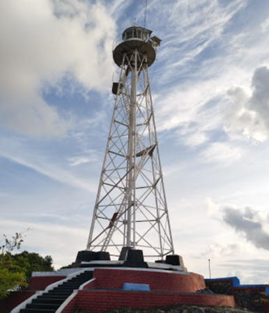
Tanjung Batutoro Light, Pulau Buton, April 2017
ex-Google Plus photo by Muhammad Aris

Wakatobi Islands Lighthouses

The Wakatobi Islands are a chain of rather small islands in the Banda Sea extending southeast from Pulau Buton and Sulawesi. The major islands are well inhabited with a total population of more than 110,000.

Wakatobi Regency Lighthouses
Karang Runduma
Date unknown. Active; focal plane about 13 m (43 ft); white light, pattern unknown. Approx. 13 m (43 ft) white skeletal tower on a platform supported by piles. No photo available but Bing has an indistinct satellite view. Located at the east end of a reef in the Banda Sea about 65 km (40 mi) northeast of the Wakatobi Islands chain. Accessible only by boat. Site open, tower closed. Admiralty Q1558.36.
Pulau Wangiwangi
Date unknown (station established 1904). Active; focal plane 150 m (492 ft); two white flashes every 12 s. 21 m (69 ft) hexagonal skeletal tower, painted white. Several coast guard station buildings. A 2018 photo is at right, Baizul Zaman has a closeup photo, Waode NaniKurnia has on Twitter a photo taken on the gallery of the lighthouse, and Google has a satellite view of the station. Pulau Wangiwangi is the largest of the islands, the closest to Pulau Buton, and the seat of the regency. Located on the northern tip of the island, 35 km (22 mi) east of Tanjung Kanolanatumbi on Pulau Buton. Site open, tower closed. ARLHS IDO-259; Admiralty Q1558; NGA 25348.
* [Wanci]
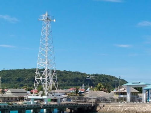
Date unknown. Active; focal plane about 12 m (39 ft); white light, pattern unknown. Approx. 12 m (39 ft) white mast on a triangular platform supported by piles. A 2021 photo is avilable, Arsyiah Waode has a 2019 closeup, and Google has a distant satellite view. Located beside the pier at Wanci, a port on the west coast of Pulau Wangiwangi. Site open, tower closed. Not listed by the Admiralty.
Pulau Tengah (Teluk Wanji, Kapota)
Date unknown. Active; focal plane 18 m (59 ft); white flash every 3 s. Approx. 16 m (52 ft) square skeletal tower painted white. Andreas Muljadi has a view from the sea and Google has a satellite view. NGA lists the light as "Midden." Located at the east end of Pulau Tengah ("Central Island") across from the waterfront of Wanci. Site status unknown. Admiralty Q1558.2; NGA 25348.5.
Karang Kapota
Date unknown. Active; focal plane about 12 m (39 ft); white light, pattern unknown. Approx. 12 m (39 ft) white skeletal tower on a platform supported by piles. No photo available but Bing has a fuzzy satellite view. Located at the northwest end of a reef about 25 km (15 mi) southwest of Wanci. Accessible only by boat. Site open, tower closed. Admiralty Q1558.25.

Pulau Wangwangi Light, Banda Sea, August 2018
Google Maps photo by aan smile
Pulau Kaledupa
2017. Active; focal plane about 20 m (66 ft); white light, pattern unknown. Approx. 20 m (66 ft) square skeletal tower mounted on a square concrete platform supported by piles. Irsyad Muhammad has a photo and Odhy Milanisti has a 2022 photo but the lighthouse apparently is too new to appear in Google's satellite view. A May 2017 aerial photo shows the platform but not the tower. Located at the northwestern tip of Pulau Kaledupa, about 13 km (8 mi) southeast of Pulau Wangiwangi. Site open, tower closed. Admiralty Q1558.27.
Karang Kaledupa
Date unknown. Active; focal plane 14 m (46 ft); white flash every 5 s. 14 m (46 ft) white beacon, form unknown, on a platform supported by piles. No photo available but Google has a distant satellite view. Located on a shoal in the narrow passage between Pulau Kaledupa and Pulau Hoga. Accessible only by boat. Site open, tower closed. Admiralty Q1558.28.
* [Pelabuhan Kaledupa]
Date unknown. Active; focal plane about 17 m (56 ft); light characteristic unknown. Approx. 17 m (56 ft) mast on a platform supported by piles. Alwinto Aidin has a distant street view and Google has a satellite view. Located beside the pier of a small port on the north side of Pulau Kaledupa. Site open, tower closed. Not listed by the Admiralty.
Waha (Karang Pulau Tomia)
Date unknown. Active; focal plane 12 m (39 ft); white flash every 5 s. 12 m (39 ft) barbell-shaped white fiberglass tower mounted on a platform supported by piles. Evi Selvia has a distant view from shore, the light is barely visible near the left edge of a view from the sea and Google has a distant satellite view. The light guides vessels toward a channel blasted through the reef off the port of Waha at the northwest end of Pulau Tomia. Accessible only by boat. Site open, tower closed. Admiralty Q1558.3; NGA 25349.
Karang Ndaa
Date unknown. Active; focal plane 12 m (39 ft); white light, 1 s on, 1 s off. 12 (39 ft) white barbell-shaped tower on a s quare platform supported by piles. No photo available but Google has a distant satellite view. Located on a reef about 16 km (10 mi) northeast of Pulau Tamio. Accessible only by boat. Site open, tower closed. Admiralty Q1558.32; NGA 25349.5.
Pulau Binongko (Tadunna)
Date unknown. Active; focal plane 45 m (148 ft); white flash every 10 s. Approx. 40 m (131 ft) octagonal white concrete tower with lantern and gallery. A travel site has the photo at right, the lighthouse appears in a YouTube video, Aldimas Rakhmat has a 2022 photo, and Google has a satellite view. Located at the southern tip of Pulau Binongko, the southernmost major island of the Wakatobi group. Site status unknown. Admiralty Q1558.34; NGA 25350.4.
Pulau Moromaho
Date unknown. Active; focal plane 45 m (148 ft); four white flashes every 10 s. Approx. 40 m (131 ft) octagonal white concrete tower with lantern and gallery. Several coast guard buildings. Muhammad Irsyad has a very distant view from the sea and Google has a satellite view of the station. Located on a small island at the extreme end of the Wakatobi Islands and at the junction of the Banda and Flores Seas. Waters around the island are a well known scuba diving site. Accessible only by boat. Site and tower closed (nature preserve). ARLHS IDO-225; Admiralty Q1558.33; NGA 25351.

Pulau Binongko Light, Banda Sea
photo posted August 2016 by Destinasian travel agency

Pulau Buton Area Lighthouses

Pulau Buton (formerly Butong) is a large island located off the southeastern tip of Sulawesi. About 120 km (75 mi) long; the island is separated from Pulau Muna to the west and the mainland to the northwest by the Buton Strait, a narrow north-south channel. The population is nearly 500,000.

Buton Utara (North Buton) Regency Lighthouses
Tanjung Loba
Date unknown. Active; focal plane 32 m (108 ft); two white flashes every 8 s. Approx. 28 m (92 ft) square skeletal tower with gallery, painted white. Google has a distant street view and a satellite view. This light guides ships into the western entrance to the Buton Strait separatingButon from the mainland. Located on a prominent point of land on the northwest coast of Pulau Buton. Site status unknown. Admiralty Q1550.5; NGA 25317.
* [Labuan Bajo]
Date unknown. Active; focal plane about 15 m (49 ft); white light, pattern unknown. Approx. 10 m (33 ft) mast. Google has a street view but the mast is hard to see in Google's satellite view. Labuan Bajo is the terminal for ferries crossing the Buton Strait to Amolengo on the mainland of Sulawesi. Google also has a street view of an approach light, a green mast on a platform supported by piles. Located at the base of the pier. Site open, tower closed. Not listed by the Admiralty.
Tanjung Buton
Date unknown. Active; focal plane 60 m (197 ft); white flash every 3 s. 10 m (33 ft) white fiberglass tower, according to NGA, but Google's satellite view reveals a white tower that appears skeletal and taller than 10 m. Located in a heavily forested area at the northern tip of Pulau Buton. Site status unknown. Admiralty Q1558.4; NGA 25311.
* [Waode Buri]
Date unknown. Active; focal plane about 14 m (46 ft); white light, pattern unknown. Approx. 12 m (39 ft) post on a square platform supported by piles. The light is at the left edge of Ruli Indra's photo and Google has an indistinct satellite view. Located on the dock of the Waode Buri port, in a sheltered bay on the northeast coast of Pulau Buton. Site open, tower closed. Admiralty Q1558.38.
* Ereve (Lasora, Teluk Koro)
Date unknown. Active; focal plane about 20 m (66 ft); white light, flash interval unknown. Approx. 18 m (59 ft) square skeletal tower painted white. Romi Wandaka has a photo (also seen at right), Difa Fitriani Sparkyu has a photo, and Google has a satellite view. Koro Bay (Teluk Koro) is a well-protected but shallow bay on the central east coast of Buton. Located on the waterfront in Ereve. Site open, tower closed. Admiralty Q1558.376.

Ereve Light, North Buton, June 2017
Google Maps photo by Romi Wandaka

Buton Regency East Coast Lighthouses
* [Pelabuhan Kamaru]
Date unknown. Active; focal plane about 12 m (39 ft); white light, pattern unknown. Approx. 10 m (33 ft) steel mast. A 2021 photo is available but the mast has not been found in Google's satellite view of the port. Located at the ferry terminal in Kamaru Bay, a protected inlet on the east coast of Pulau Buton. Not listed by the Admiralty.
Tanjung Kanolanatumbi
Date unknown. Active; focal plane 45 m (148 ft); white flash every 10 s. 30 m (98 ft) white concrete tower with lantern and gallery. A photo is at right and Google has a satellite view. This light stands on the eastern point of Pulau Buton. Site status unknown. ARLHS IDO-302; Admiralty Q1555.8; NGA 25346.
* Banabungi
Date unknown. Active; focal plane about 25 m (82 ft); white light, pattern unknown. Approx. 22 m (72 ft) square white skeletal tower mounted on a square platform. A 2021 photo and a distant photo are available and Google has a satellite view. Located at the ferry terminal of Banabungi, on Wajo Bay on the southeast coast of Pulau Buton. Site open, tower closed. Not listed by the Admiralty.
Tanjung Kondowa (Kordoa)
Date unknown. Active; focal plane 20 m (66 ft); white flash every 4 s. Approx. 12 m (39 ft) white concrete tower. No photo available but Google has a satellite view. Located on a promontory on the southeast coast of Pulau Buton. Site status unknown. Admiralty Q1555; NGA 25344.

Buton Selatan (South Buton) Regency Lighthouses
Tanjung Batu Toro (Batutoro)
Date unknown. Active; focal plane 50 m (164 ft); white flash every 10 s. Approx. 35 m (115 ft) octagonal white concrete tower with lantern and gallery. A photo by Muhammad Aris is at the top of this page and Google has a good satellite view. This major lighthouse seems to be very poorly known. Located at the southeastern tip of Pulau Buton. Site open, tower closed. Admiralty Q1554.4; NGA 25342.
Pulau Batuatas (Batuata, Batu Atas)
Date unknown. Active; focal plane 144 m (472 ft); two white flashes every 5 s. Described only as a white beacon, this light appears to be a round white concrete or fiberglass tower perhaps 20 m (66 ft) tall. Ali Putra has a very distant view (the light is atop the ridge in the upper left corner of the photo) and Google has a satellite view. Located at or near the summit of an isolated (but inhabited) high island about 32 km (20 mi) south of the southern tip of Pulau Buton. Site status unknown. Admiralty Q1553.2; NGA 25352.5.
Tanjung Kanolanatumbi Light
Tanjung Kanolanatumbi Light, Pulau Buton
photo copyright musafirtimur; used by permission
Tanjung Masige (Tanjung Masiga, Pulau Siumpu)
Date unknown. Active; focal plane 20 m (66 ft); white flash every 5 s. 19 m (62 ft) square skeletal tower, painted white. No photo available but Google has a satellite view. Located on a reef off the southwestern tip of Pulau Siumpu, an island off the southwestern tip of Butan. Site status unknown. ARLHS IDO-280; Admiralty Q1553; NGA 25352.
* Pulau Kadatua (Tanjung Bauabungi)
Date unknown. Active; focal plane 15 m (49 ft); three white flashes every 10 s. 15 m (49 ft) square skeletal tower, painted white, mounted on a platform supported by four robust piles. A 2020 closeup photo is at right, Mardan Tambang has a photo, and Google has a satellite view. Located just off the northern tip of Pulau Kadatua, an island about 10 km (6 mi) southwest of Baubau. Site open, tower closed. Admiralty Q1552.6; NGA 25340.

Baubau City Lighthouses
Located at the southwestern end of Pulau Buton, Baubau is the principal city of the island; it has a population of about 140,000.

Selat Masiri (Karang Masiri)
Date unknown. Active; focal plane about 12 m (39 ft); red light, pattern unknown. Approx. 12 m (39 ft) round barbell-shaped tower on a triangular platform supported by piles. No photo available but Google has a satellite view. Located on a dangerous reef in the middle of the Masiri Strait separating Pulau Kadatua from Pulau Buton. Site open, tower closed. Admiralty Q1552.5.
* Baubau
Date unknown. Active; focal plane 12 m (39 ft); white flash every 4 s. Approx. 11 m (36 ft) round barbell-shaped white fiberglass tower mounted on a square 1-story equipment building. Ar Roofi Nurul has a 2022 photo, Bernard Tan has a photo, Zul Lenovo has a photo, and Google has an indistinct satellite view. Located on the side of a quay at Baubau. Site open, tower closed. Admiralty Q1552; NGA 25332.
Pulau Makasar
Date unknown. Active; focal plane 11 m (36 ft); red flash every 3 s. 11 m (36 ft) round red barbell-shaped tower on a triangular platform supported by piles. No photo available but Google has a satellite view. Located on a reef west of the south point of Pulau Makasar, an inhabited island north of the Baubau waterfront. Site open, tower closed. Admiralty Q1551.9; NGA 25331.
Tanjung Batu Sori (Batusori)
Date unknown. Active; focal plane 25 m (82 ft); white flash every 3 s. Approx. 20 m (66 ft) barbell-shaped white fiberglass tower. No photo available but Bing has a satellite view. Located on the west coast of Buton at the narrowest point of the Buton Strait. Site status unknown. Admiralty Q1551.8; NGA 25330.

Pulau Kabatua Light, Buton Selatan, July 2020
Google Maps photo by Risman Photography

Buton Regency West Coast Lighthouse
Gosong Kulaga
Date unknown. Active; focal plane 15 m (49 ft); white flash every 3 s. 15 m (49 ft) round white barbell-shaped tower on a square platform supported by piles. No photo available but Bing has a satellite view. NGA lists the light as "Pulau Buton." Located on a reef in the Buton Strait off the central west coast of Pulau Buton in the Buagi area. Site open, tower closed. Admiralty Q1551.6; NGA 25329.

Muna Regency: Pulau Buton West Coast Lighthouses
Most of Muna Regency is on Pulau Muna (see below) but the regency also includes a strip of the west coast of Pulau Buton.

Pulau Lebutan
Date unknown. Active; focal plane 20 m (66 ft); two white flashes every 8 s. 15 m (49 ft) skeletal tower, painted white. Zubair Alhawari has a photo and Google has a satellite view of the tower peeking through trees. Located on an island in the channel on the west side of Buton. Accessible only by boat. Site status unknown. ARLHS IDO-154; Admiralty Q1551.5; NGA 25328.
Pulau Puning
Date unknown. Active; focal plane about 12 m (39 ft); white light, pattern unknown. Approx. 12 m (39 ft) barbell-shaped white fiberglass tower mounted on a platform supported by piles. No photo available but Google has a satellite view. This light guides ferries between Raha on Pulau Muna and Pure on Pulau Buton. Located at the end of a long sandbar extending northward from Pulau Puning, a small island in the Buton Strait north of Pulau Lebutan. Accessible only by boat. Site open, tower closed. Admiralty Q1551.25.
* Maligano
Date unknown (recent). Active; focal plane about 22 m (72 ft); white light, pattern unknown. Approx. 20 m (66 ft) square white skeletal tower. Syah Rizal's 2021 photo is at right, Jafar Luk has a 2021 photo, a May 2019 closeup is available, and Google has a satellite view. However, the light is missing from an April 2016 Google street view. Maligano is a small port on the west coast of Pulau Buton. Located on the main pier at Maligano. Site open, tower closed. Admiralty Q1550.6.

Maligano Light, Maligano, August 2021
Google Maps photo by Syah Rizal

Pulau Muna Area Lighthouses

Pulau Muna lies just to the west of Pulau Buton, separated from it by the narrow Buton Strait. The island is about 75 km (47 mi) long and as much as 40 km (25 mi) wide; it has a population of about 325,000.

Muna Regency Lighthouses
* Tampo
Date unknown. Active; focal plane 12 m (39 ft); white flash every 3 s. 10 m (33 ft) square white skeletal tower. Fadjar Barakati's photo is at right, Google has a street view and a satellite view. Located near the foot of the pier at Tampo, on the northeastern end of Pulau Muna. Site open, tower closed. Admiralty Q1550; NGA 25318.
Tampo Approach
Date unknown. Active (?); focal plane about 12 m (39 ft); light characteristic, if any, unknown. Approx. 12 m (39 ft) square white skeletal tower mounted on a platform supported by piles. Adi Sentral has a closeup photo, Ronni Syahputra has a distant view, and Bing has a satellite view. Located about 200 m (220 yd) off the end of the pier at Tampo. Accessible only by boat. Site open, tower closed. Not listed by the Admiralty.
Pulau Ranta
Date unknown. Active; focal plane 12 m (39 ft); three white flashes every 10 s. White tower, probably skeletal, on a paltform supported by piles. No photo available and the lighthouse is not shown on Google's satellite view. The light guides ships through a narrow passage, less than 2.5 km (1.5 mi) wide, between Tampo and the reefs fringing the south side of Pulau Ranta. Accessible only by boat. Site open, tower closed. Admiralty Q1550.3.
* Raha Pierhead (2?)
Date unknown. Active; focal plane 15 m (49 ft); white flash every 3 s. 15 m (49 ft) square white skeletal tower. Suhirman Simal has a 2018 photo, another photo is available, and Google has a satellite view and a distant street view. It appears that the light was moved from the pierhead when an extension was added to the pier. Located beside the pierhead at Raha, the regency capital and largest town of Pulau Muna, on the northeast side of the island. Site open, tower closed. Admiralty Q1551.1 (ex-Q1551); NGA 25324.
Raha (Approach) (2?)
Date unknown. Active; focal plane 17 m (56 ft); two white flashes every 5 s. 17 m (56 ft) skeletal tower on a square platform supported by piles. No photo available but Bing has a satellite view. Located on a shoal about 800 m (1/2 mi) east southeast of the Raha pier. Site open, tower closed. Admiralty Q1551.23 (ex-Q1551.2); NGA 25320.
Karang Bangka
Date unknown. Active; focal plane 12 m (39 ft); three white flashes every 10 s. 12 m(39 ft) white tower, a mast with gallery or a fiberglass tower, on a platform supported by piles. No photo available but Bing has a fuzzy satellite view. Located on a shoal in the Buton Strait off the easternmost point of Muna Island. Accessible only by boat. Site open, tower closed. Admiralty Q1551.3.

Tampo Light, Pulau Muna, December 2017
ex-Google Plus photo by Fadjar Barakati
Karang Bali
Date unknown. Active; focal plane 12 m (39 ft); two white flashes every 7 s. 12 m (39 ft) tower painted black with one red horizontal band, on a platform supported by piles. No photo available but Bing has a fuzzy satellite view. Located on a shoal in the Buton Strait about 3 km (2 mi) south southwest of Karang Bangka. Accessible only by boat. Site open, tower closed. Admiralty Q1551.4.

Buton Tengah (Central Buton) Regency Lighthouses
Despite its name Central Buton Regency does not include any part of Pulau Buton; it includes the southern coasts of Pulau Muna and Pulau Kabeana, islands to the west of Pulau Buton. See the Southeast Sulawesi page for lighthouses of Pulau Kabaena.
* [Pelabuhan Lanto]
Date unknown (recent). Active; focal plane about 13 m (43 ft); light characteristic unknown. Approx.13 m (43 ft) white mast on a platform supported by piles. Bayu Arsenius has a 2021 photo and Google has a satellite view but the light is not seen in a 2016 Google street view. Located at the base of the pier at Lanto, a village at the head of a long inlet on the south coast of Pulau Muna. Site open, tower closed. Not listed by the Admiralty.
* [Mawasangka]
Date unknown. Active; focal plane about 13 m (43 ft); light characteristic unknown. Approx.13 m (43 ft) white mast on a platform supported by piles. Rhoni Saputro has a 2019 view and Bing has a satellite view. Located beside the outer end of the pier at the Mawasangka ferry terminal on the southwest coast of Pulau Muna. Site open, tower closed. Not listed by the Admiralty.
* Telaga Raya
Date unknown. Active; focal plane about 20 km (66 ft); white light, pattern unknown. Approx. 20 m (66 ft) square white skeletal tower on a square platform supported by piles. Kukuh Panaringan has the 2022 photo at right, Laode Rasyid has a 2023 photo, and Google has a satellite view. Telaga Raya (also called Telaga Kecil) is a small but densely populated island just off the southeastern tip of Pulau Kabaena. Located just off the main quay of Telaga Raya. Site open, tower closed. Not listed by the Admiralty.
Telaga Besar
Date unknown. Active; focal plane 42 m (138 ft); two white flashes every 15 s. Approx. 40 m (131 ft) square pyramidal skeletal tower, painted white. Coast guard station with several station buildings. No photo available but Google has a satellite view of the station. This light marks the eastern entrance to the Gulf of Boni from the Flores Sea. Located at the west end of Telaga Besar, a small island off the south end of the much larger Pulau Kabaena. Accessible only by boat. Site status unknown. Admiralty Q1553.5; NGA 25374.

Telaga Raya Light, Telaga Raya, April 2022
Google Maps photo by Kukuh Panaringan
 

Muna Barat (West Muna) Regency (Tioro Strait) Lighthouses
The Tioro Strait resembles a gulf more than a strait; except for a very narrow passage around the northern tip of Pulau Muna at its northeastern end it is a broad bay that separates the Southeast Sulawesi peninsula from Pulau Muna. Navigation in the strait is hampered by extensive reefs extending from the northwest coast of Pulau Muna.

Karang Sapatarapimpi
Date unknown. Active; focal plane 12 m (39 ft); two white flashes every 7 s. Approx. 10 m (33 ft) round barbell-shaped white fiberglass tower. No photo available but Bing has a satellite view. Located on a reef at the north end of the Muna Strait, which separates Pulau Muna from Pulau Kabaena. Accessible only by boat. Site open, tower closed. Admiralty Q1549.35; NGA 25319.3.
Karang Sapamataha
Date unknown. Active; focal plane 12 m (39 ft); two white flashes every 6 s. Approx. 10 m (33 ft) round barbell-shaped white fiberglass tower. No photo available but Bing has a satellite view. Located on a reef about 15 km ( mi) north of the Karang Sapatarapimpi light. Accessible only by boat. Site open, tower closed. Admiralty Q1549.3; NGA 25319.1.
Pulau Magenti
Date unknown. Active; focal plane 12 m (39 ft); two green flashes every 6 s. 12 m (39 ft) square green skeletal tower on a platform supported by piles. No photo available but Google has a distant satellite view. Pulau Magenti is an inhabited island in the center of the Tioro Strait; the main entrance to the strait is just to the west. Located on a reef at the west end of the island. Accessible only by boat. Site open, tower closed. Admiralty Q1549.2; NGA 25319.
* Tondasi
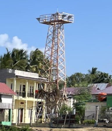
Date unknown. Active; focal plane 12 m (39 ft); white light, flash interval unknown. Approx. 10 m (33 ft) square skeletal tower painted white. Google has the street view at right and a distant satellite view. Located on the waterfront in Tondasi, a ferry port on the northwestern coast of Pulau Muna. Site open, tower closed. Admiralty Q1549.17.
Pulau Maloan (Karang Maloang)
Date unknown. Active; focal plane 12 m (39 ft); white flash every 5 s. 12 m (39 ft) post with gallery on a triangular platform supported by piles. No photo available but Bing has a satellite view. Located at the western end of the reefs. Accessible only by boat. Site open, tower closed. Admiralty Q1549.05; NGA 25318.8.
Karang Beromasidi (Karang Selat Tioro)
Date unknown. Active; focal plane 12 m (39 ft); two white flashes every 5 s. 12 m (39 ft) square white skeletal tower on a platform supported by piles. No photo available but Bing has a satellite view. Located at the northwestern end of the reefs and off the northwestern side of Pulau Bero. Accessible only by boat. Site open, tower closed. Admiralty Q1549.1; NGA 25318.6.
Karang Beromadilao
Date unknown. Active; focal plane 12 m (39 ft); two white flashes every 7 s. 12 m (39 ft) square white skeletal tower on a platform supported by piles. No photo available but Bing has a satellite view. Located at the northeastern end of the reefs. Accessible only by boat. Site open, tower closed. Admiralty Q1549.15; NGA 25318.4.

Tondasi Light, Tondasi, April 2016
Google Maps street view

Information available on lost lighthouses:

Notable faux lighthouses:

Adjoining pages: North: Northern Sulawesi | East: North Maluku | Southeast: Central Maluku | South: Lombok and Sumbawa | West: Western Sulawesi

Return to the Lighthouse Directory index | Ratings key

Posted December 18, 2008. Checked and revised July 15, 2023. Lighthouses: 44. Site copyright 2023 Russ Rowlett and the University of North Carolina at Chapel Hill.