Lighthouses of Indonesia: South Sulawesi (Celebes) Islands

Indonesia has been independent since 1945 after having been the Dutch East Indies for more than 350 years. It is a huge country, stretching along both sides of the Equator for more than 46 degrees of longitude (roughly 5100 km or 3200 miles). Comprised of some 17,000 islands (more than 6000 inhabited islands), it has hundreds of major aids to navigation. This is one of eight pages for lighthouses of Sulawesi (Celebes), a major island in the northern part of the country.

Shaped like an artistically drawn letter K, Sulawesi consists mostly of four narrow peninsulas. The Makassar Strait separates Sulawesi from Kalimantan (Borneo) to the west. The Celebes Sea is north of the island, the Molucca Sea is on the northeast, the Banda Sea is to the southeast, and the Flores Sea is on the south.

Indonesia is divided into 34 provinces and the provinces are subdivided into regencies (kabupaten). This page covers two island regencies of South Sulawesi Province, the Selayer Islands Regency and the islands of the Pangkajene and Islands Regency.

In Indonesian a lighthouse is a mercusuar or a menara suar. Tanjung is a cape, ujung is a headland or point of land, bukit is a hill, sungai is a river, kuala or muara is an estuary or river mouth, pulau is an island, karang is a reef, batu is a rock, laut is a sea, selat is a strait, teluk is a bay, pelabuhan is a harbor, and labuhan is a port.

Aids to navigation in Indonesia are operated and maintained by the Directorate of Marine Navigation within the Directorate General of Sea Transportation.

ARLHS numbers are from the ARLHS World List of Lights. Admiralty numbers are from volumes F and Q of the Admiralty List of Lights & Fog Signals. U.S. NGA List numbers are from Publication 112.

General Sources
Online List of Lights - Indonesia
Photos by various photographers posted by Alexander Trabas.
Indonesian Lighthouses
Historic postcard views from the collection of Michel Forand.
World of Lighthouses - Indonesia
Photos by various photographers available from Lightphotos.net.
Sulawesi Map
A useful map from orangesmile.com.
Navionics Charts
Navigation chart for Sulawesi.

New and old Pulau Bonerate Lights, Pulau Bonerate, May 2022
Google Maps photo by Rauf Mansyur

Kepulauan Selayar (Selayer Islands) Regency Lighthouses

The Selayer Islands extend south and then southeast irom the southeastern tip of Sulawesi's Southern Peninsula. Pulau Selayer, a long island extending north and south, is the largest and northernmost of the islands. The International Hydrographic Organization defines the island chain to be part of the boundary between the Flores Sea to the west and the Banda Sea to the east. The islands have about 140,000 residents including about 90,000 on Pulau Selayer.

Pulau Selayer Lighthouses
Pulau Pasi South
Date unknown. Active; focal plane about 14 m (46 ft); red light, pattern unknown. Approx. 14 m (46 ft) tower, probably a round barbell-shaped red fiberglasson a square platform supported by piles. No photo available but Bing has a fuzzy satellite view. Located off the southeastern tip of Pulau Pasi, an island sheltering the harbor of Benteng. Accessible only by boat. Site open, tower closed. Charted by Navionics but not listed by the Admiralty.
* Benteng
Date unknown. Active; focal plane 14 m (46 ft); white flash every 5 s. 12 m (39 ft) square skeletal tower, painted white and mounted on a square 1-story equipment shelter. Swas Harimurti has a photo, another photo is available, and Google has a satellite view. Located on the waterfront at Benteng, the regency capital and ferry port on the central west coast of Pulau Selayer. Site open, tower closed. Admiralty Q1538.
Pulau Pasi North
Date unknown. Active; focal plane about 14 m (46 ft); green light, pattern unknown. Approx. 14 m (46 ft) round barbell-shaped green fiberglass tower on a square platform supported by piles. No photo available but Bing has a satellite view. Located off the northeastern tip of Pulau Pasi, an island sheltering the harbor of Benteng. Accessible only by boat. Site open, tower closed. Admiralty Q1537; NGA 25417.
Pulau Pasitanete (Menara Indah) (3)
Date unknown (station established 1898). Active; focal plane 65 m (213 ft); four white flashes every 20 s. 40 m (131 ft) square white skeletal tower with gallery. Lighthouse painted white, lantern red. Several coast guard buildings. A photo is at right, Pariyati Yati has a 2019 closeup, Lili Waly has another 2019 closeup, and Google has a satellite view of the station. The 2019 photos show that the lantern has been removed. The original lighthouse had a focal plane height of only 45 m (148 ft). The lighthouse marks the narrow Selayer Strait separating the Selayer Islands from Tanjung Bira, the southern tip of Suluwesi. Located on a small island off the northern end of the much larger island of Selayar, about 30 km (19 mi) southeast of Bulukumba. Accessible only by boat. Site open, tower closed. ARLHS IDO-234; Admiralty Q1536; NGA 25408.
 
Pulau Pasitanete Light
Pulau Pasitanete Light, Selayer, May 2007
ex-Panoramio photo copyright MACTAK MC; used by permission
 
* Pamatata
Date unknown. Active (?); focal plane about 30 m (98 ft); white light, pattern unknown. Approx. 15 m (49 ft) square skeletal tower with gallery, painted white. Taufik Temanggung's photo is at right and Google has a satellite view. Rahmat Zulkifli Rahman has a 2021 photo of a light on a mast about 20 m (66 ft) tall adjacent to the ferry pier. Located at the ferry terminal at Pamatata on the northeast coast of Pulau Selayer. Site open, tower closed. Not listed by the Admiralty.
* Patumbukang
Date unknown. Active; focal plane 15 m (49 ft); white flash every 5 s. 12 m (39 ft) square skeletal tower with gallery, painted white. Muh Rajih Musdar has a photo and Google has a distant satellite view. Located on a bluff beside the pier at the ferry terminal at Patumbukang on the southeast coast of Pulau Selayer. Site open, tower closed. Admiralty Q1539.
Karang Nambolaki
Date unknown. Active; focal plane 12 m (39 ft); white flash every 10 s. 12 m (39 ft) tower, probably a skeletal tower, on a platform supported by piles. No photo available and the lighthouse is not shown in Bing's satellite view of the reef. The light guides ships around an extensive area of reefs and shoals southeast of Pulau Selayer. Located west of Pulau Talon and about 30 km (19 mi) southwest of the southern tip of Pulau Selayer. Accessible only by boat. Site status unknown. Admiralty Q1326; NGA 25661.3.

Take Bonerate Islands Lighthouses
Pulau Belangbelang
Date unknown. Active; focal plane 16 m (52 ft); white flash every 5 s. 10 m (33 ft) round barbell-shaped white fiberglass tower. No photo available but Bing has a distant satellite view. This light warns ships away from the Take Bonerate Islands, a large area of reefs and shoals southeast of Pulau Selayer. Located on a small island at the northern end of the Take Bonerate Islands, about 80 km (50 mi) east of Pulau Selayer. Accessible only by boat. Site status unknown. Admiralty Q1327.2; NGA 25662.2.

Pamatata Light, Selayer
ex-Panoramio photo copyright Taufik Temanggung; used by permission
* Pulau Raja
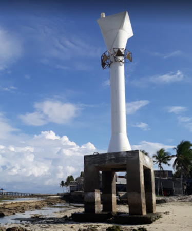
Date unknown. Active; focal plane 12 m (39 ft); white flash every 2 s. 12 m (39 ft) round barbell-shaped white fiberglass tower mounted on a concrete platform supported by piles. A 2018 photo is at right, Asri To has a sunset photo, and Google has a satellite view. Located on the beach near the south end of Pulau Raja, a small inhabited island at the southern end of the Take Bonerate Islands and about 25 km (15 mi) north of Pulau Bonarate. Site open, tower closed. Admiralty Q1327.7; NGA 25664.
Pulau Jinato South
Date unknown. Active; focal plane about 12 m (39 ft); green light, pattern unknown. Approx. 12 m (39 ft) square green skeletal tower on a platform supported by piles. A very distant view is available and Bing has a distant satellite view. Located off the islet of Pulau Jinato marking the south side of a narrow break in the west side of the Take Bonerate reef. Accessible only by boat. Site open, tower closed. Admiralty Q1327.05.
Pulau Jinato North
Date unknown. Active; focal plane about 12 m (39 ft); red light, pattern unknown. Approx. 12 m (39 ft) square red skeletal tower on a platform supported by piles. A very distant view is available and Bing has a distant satellite view. Located off the islet of Pulau Jinato marking the south side of a narrow break in the west side of the Take Bonerate reef. Accessible only by boat. Site open, tower closed. Admiralty Q1327.05.

Pulau Kayuadi Lighthouses
Pulau Kayuadi
Date unknown. Active; focal plane 13 m (43 ft); two white flashes every 30 s. 13 m (43 ft) white tower on a platform supported by piles. No photo available and the light is not shown in Bing's satellite view. Located on a shoal off the northern tip of Pulau Kayuadi, an island about 35 km (22 mi) southeast of the southern tip of Pulau Selayer. Accessible only by boat. Site open, tower closed. Admiralty Q1327; NGA 25662.
Pelabuhan Kayuadi
Date unknown. Active; focal plane 14 m (46 ft); white flash every 5 s. 14 m (46 ft) white skeletal tower on a platform supported by piles. A 2023 view is available, Isa Nur Anshari has a 2021 photo showing this light on the left and the Kayuadi East light in the right distance. Google has a satellite view. Located on the north side of the base of the ferry pier on the east coast of Pulau Kayuadi. Site open, tower closed. Admiralty Q1326.9.

Pulau Raja Light, Tambuna, March 2018
Google Maps photo by Mr. Of Vellage
Pelabuhan Kayuadi East
Date unknown. Active; focal plane 14 m (46 ft); red flash every 4 s. 14 m (46 ft) red skeletal tower on a platform supported by piles. Isa Nur Anshari has a 2021 photo showing this light in the right distance, the light is at the right edge of Selalu Bersyukur's photo, and Google has an indistinct satellite view. Located off the end of the ferry pier on the east coast of Pulau Kayuadi. Site open, tower closed. Admiralty Q1326.8.

Pulau Jampea Lighthouses
Karang Sane-Sane
Date unknown. Active; focal plane 15 m (49 ft); white flash every 5 s. 15 m (49 ft) white fiberglass tower on a platform supported by piles. No photo available but Bing has a satellite view. This reef is at the point where the Selayer Island chain curves from north-south to northwest-southeast. Located on a reef about 25 km (15 mi) northeast of Pulau Jampea. Accessible only by boat. Site open, tower closed. Admiralty Q1326.5.
Ujung Perumang (Tanjung Ringgi, Pulau Jampea)
Date unknown. Active; focal plane 11 m (36 ft); white flash every 5 s. Approx. 10 m (33 ft) "white beacon." No photo available; Google's distant satellite view suggests a white fiberglass tower. Located at the southeastern tip of Pulau Jampea. Site status unknown. Admiralty Q1327.5; NGA 25662.5.

Pulau Kalao and Pulau Bonerate Lighthouses
Pulau Kalao (Lambego)
Date unknown. Active; focal plane about 12 m (39 ft); green light, pattern unknown. Approx. 12 m (39 ft) square pyramidal white skeletal tower mounted on a square platform supported by piles. No photo available but Google has an indistinct satellite view. Located just off the northeastern tip of Pulau Kalao, where it marks the narrow passage between Kalao and Bonerate. Accessible only by boat. Site open, tower closed. Admiralty Q1327.9.
Pulau Bonerate (1)
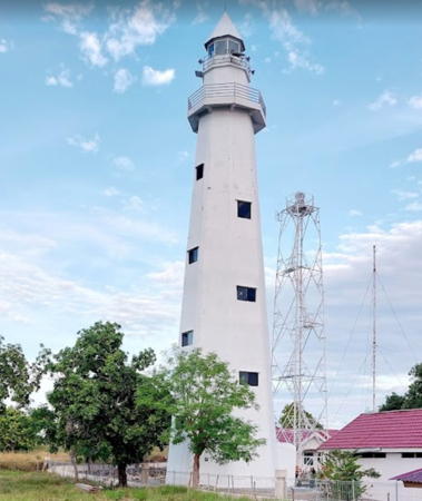
Date unknown. Inactive since 2022. 25 m (82 ft) square skeletal tower, painted white. Several coast guard station buildings. Rauf Mansyur has a 2022 photo of the old and new lighthouses. Located on the southwest side of Pulau Bonerate, an island in the Flores Sea near the southeastern end of the Selayer group. Site status unknown.
Pulau Bonerate (2)
Date unknown. Active; focal plane about 70 m (230 ft); three white flashes every 10 s. 30 m (98 ft) octagonal white concrete tower with lantern and gallery. Several coast guard station buildings. Rauf Mansyur has the 2022 photo at the top of this page and Google has a satellite view of the station. Located adjacent to the older light. Site status unknown. Admiralty Q1328; NGA 25663.
Pulau Bonerate West
2020. Active; focal plane 14 m (46 ft); green flash every 3 s. 14 m (46 ft) square skeletal tower, painted green and mounted on a platform support by piles. No photo available but Google has a distant satellite view. Located on a shoal about 800 m (1/2 mi) southwest of the Bonerate waterfront. Accessible only by boat. Site open, tower closed. Admiralty Q1327.98.
Bonerate
Date unknown. Active; focal plane 15 m (49 ft); red flash every 5 s. 15 m (49 ft) square skeletal tower, painted red and mounted on a platform support by piles. Berbagai Hal Cuk has the photo seen at right and Google has a fuzzy satellite view. Located off the pier at Bonerate harbor, on the west side of the island. Admiralty Q1327.95.

Bonerate Light, Selayer Islands
Google Maps photo by Berbagai Hal Cuk
* Pelabuhan Bonerate
Date unknown. Active; focal plane about 16 m (52 ft); white light, characteristic unknown. Approx. 12 m (39 ft) square skeletal tower, painted white and mounted on a platform support by piles. Kristofer Liku Tande Padang has a photo (a portion is seen at right), Sandas Block has a distant view (the tower is seen just to the right of the yellow waterfront building), and Google has an indistinct satellite view. Located on the waterfront at Bonerate harbor. Not listed by the Admiralty.

Eastern Bonerate Islands Lighthouses
Pulau (Karang) Sangi Sangiang
Date unknown. Active; focal plane 12 m (39 ft); white light, 2 s on, 9 s off. 12 m (39 ft) white tower on a square platform supported by piles. No photo available but Bing has a satellite view. Located on a reef about 50 km (30 mi) northeast of Pulau Bonerate. Accessible only by boat. Site status unknown. Admiralty Q1327.8; NGA 25665.
North Pulau Kalatoa (Approach Right)
2020. Active; focal plane 14 m (46 ft); green flash every 4 s. 14 m (46 ft) square skeletal tower, painted green and mounted on a platform support by piles. No photo available but Bing has a satellite view. Kalatoa is a substantial island about 65 km (40 mi) east of Bonerate. Located on the west side of the channel approaching the harbor of Pulau Kalatoa, on the north side of the island. Accessible only by boat. Site open, tower closed. Admiralty Q1328.91.
North Pulau Kalatoa (Approach Left)
2020. Active; focal plane 14 m (46 ft); red flash every 5 s. 14 m (46 ft) square skeletal tower, painted red and mounted on a platform support by piles. A very distant view is available and Bing has a satellite view. Located on the east side of the channel approaching the harbor of Pulau Kalatoa, on the north side of the island. Accessible only by boat. Site open, tower closed. Admiralty Q1328.9.
* Pelabuhan Kalatoa
Date unknown. Active; focal plane about 16 m (52 ft); white light, pattern unknown. Approx. 14 m (46 ft) square skeletal tower, painted white. The light is at the left edge of Rauf Mansyur's view from the end of the pier, Mimin Suralim has a distant 2022 view, and Google has a satellite view. Located on the waterfront at the Pulau Kalatoa ferry terminal. Site open, tower closed. Not listed by the Admiralty.

Pelabuhan Bonerate Light, Bonerate, May 2021
Google Maps photo by Kristofer Liku Tande Padang
Pulau Kaunadi
Date unknown. Active; focal plane 12 m (39 ft); white flash every 2 s. 12 m (39 ft) "white beacon." No photo available and the light has not been found in Bing's satellite view. Located near the east end of Pulau Kaunadi, an uninhabited island at the eastern end of the Selayer group. Accessible only by boat. Site status unknown. Admiralty Q1328.7 NGA 25668.
Pulau Kakabia
Date unknown. Active; focal plane 11 m (36 ft); white flash every 2 s. 10 m (33 ft) round white fiberglass tower. No photo available but Google has a distant satellite view. Located near the south end of Pulau Kakabia, an uninhabited island at the extreme eastern end of the Selayer group. Accessible only by boat. Site status unknown. Admiralty Q1328.5 NGA 25666.

Pangkajene Dan Kepulauan (Pangkajene and Islands) Regency: Island Lighthouses

The Pangkajene Dan Kepulauan (Pangkajene and Islands) Regency has a mainland territory north of Makassar as well as numerous islands to the south and southwest in the Makassar Strait and the Flores Sea. The mainland portion of the regency is covered on the South Sulawesi Mainland page.

Spermonde (Sangkarang) Islands Lighthouses
The Spermonde Islands include some 120 islands and sandy reefs in the Strait of Makassar northwest of Makassar City.
Pulau Lanyukang (Lanjukang)
Date unknown. Active; focal plane 24 m (79 ft); white flash every 10 s. 20 m (66 ft) round white concrete tower with 8 ribs, lantern and gallery. Randal Bappeda has the 2021 photo at right, a closeup and another 2021 photo are available and Google has a satellite view. Located on an islet about 40 km (25 mi) northwest of Makassar (the outermost of a large group of small islands). Accessible only by boat. Site status unknown. Admiralty Q1508.5; NGA 25461.
Karang Takabakang
Date unknown. Active; focal plane 15 m (49 ft); white flash every 5 s. 15 m (49 ft) square white skeletal tower on a platform supported by piles. No photo available but Bing has a satellite view. Located on the north side of an isolated reef about 50 km (30 mi) west of Pulau Lanyukang. Accessible only by boat. Site open, tower closed. Admiralty Q1509; NGA 25425.
Bone Penambungan
Date unknown. Active; focal plane 15 m (49 ft); green flash every 4 s. 15 m (49 ft) square skeletal tower, painted white and mounted on a platform supported by piles. No photo available but Google has a satellite view. Located on a shoal about 20 km (13 mi) north of Makassar. This one and the next one guide ships through the maze of reefs to Makassar. Accessible only by boat. Site open, tower closed. Admiralty Q1510; NGA 25460.
Batu Bayangan
Date unknown. Active; focal plane 15 m (49 ft); red flash every 3 s. 15 m (49 ft) square red skeletal tower mounted on a platform supported by piles. No photo available but Google has a satellite view. Located on a shoal about 10 km (6 mi) north of the Bone Penambungan light. Accessible only by boat. Site open, tower closed. Admiralty Q1509.5; NGA 25464.

Pulau Lanyukang Light, Spermonde Islands, July 2021
Google Maps photo by Randal Bappeda
Pulau Kapoposang (1)
1906. Inactive since 1957and possibly removed. Approx. 25 m (82 ft) cast iron tower with lantern and gallery, painted white. Andika Ferial's distant 2008 view from the sea (no longer online) showed this historic Dutch lighthouse and its modern replacement. Site open, tower closed.
Pulau Kapoposang (2)
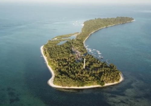
1957 (station established 1906). Active; focal plane 36 m (118 ft); white flash every 5 s. 33 m (108 ft) skeletal tower with lantern and gallery, painted red (?). Several coast guard station buildings. A distant aerial view is at right, S. Budiarto has a very distant photo, and Bing has an indistinct satellite view of the station. This important light station marks the westernmost of the Spermonde Islands and reefs in the southeastern quadrant of the Makassar Strait. Kapoposang has a resort and is a popular destination for scuba divers. Located at the west point of an island in the Makassar Strait, about 100 km (60 mi) northwest of Makassar in southwestern Sulawesi. Accessible only by boat. Site open, tower closed. ARLHS IDO-022; Admiralty Q1508; NGA 25468.
Gosong Pankamantra
Date unknown. Active; focal plane 15 m (49 ft); white flash every 5 s. 15 m (49 ft) white tower on a platform supported by piles. No photo available and the light is not shown in Google's satellite view. Located at the northernmost extremity of the Spermonde reefs, about 35 km (22 mi) off the mainland coast. Accessible only by boat. Site open, tower closed. Admiralty Q1507.5; NGA 25482.

Strait of Makassar Southern Entrance Lighthouses
These lighthouses mark a rough chain of reefs and islands dangerously obstructing the southern entrance to the Strait of Makassar.

Kapoposang Lights, Makassar Strait
unattributed photo posted by Indonesian Wikipedia
Pulau Sabaru
Date unknown. Active; focal plane 42 m (138 ft); three white flashes every 16 s. 40 m (131 ft) square tapered skeletal tower with lantern and gallery, painted white; lantern painted red. No photo available but Bing has a satellite view of the station. The deepwater passage into the Strait of Makassar from the southwest runs between this light and the next one. Located on the southeast side of Pulau Sabaru about 100 km (60 mi) west northwest of Pulau Kalu Kalukuang. Accessible only by boat. Site status unknown. ARLHS IDO-026; Admiralty Q1442.5; NGA 24980.
Pulau Kalu Kalukuang
Date unknown. Active; focal plane 44 m (144 ft); four white flashes every 30 s. 40 m (131 ft) square tapered skeletal tower with lantern and gallery, painted white. Taufik Temanggung's closeup photo is at right, he also has a view from the sea, and Google has a satellite view of the station. Located at the north end of a small but inhabited island in the middle of the south entrance to the Makassar Strait, about 180 km (110 mi) west of Makassar. Accessible only by boat. Site status unknown. ARLHS IDO-139; Admiralty Q1442.7; NGA 24982.
Pulau Doangdoangan Besar
Date unknown. Active; focal plane 41 m (148 ft); three white flashes every 20 s. 40 m (131 ft) square tapered skeletal tower with lantern and gallery, painted white. No photo available but Google has an indistinct satellite view of the station. The deepwater passage into the Strait of Makassar from the south and southeast runs between this light and the next one. Located at the south end of a small but inhabited island in the middle of the south entrance to the Makassar Strait, about 150 km (90 mi) west of Makassar. Accessible only by boat. Site status unknown. ARLHS IDO-126; Admiralty Q1443.5; NGA 24986.
Pulau Dewakang Besar
Date unknown. Active; focal plane 33 m (108 ft); white flash every 5 s. 30 m (98 ft) square white skeletal tower with gallery. Several coast guard station buildings. Taufik Temanggung has a closeup photo and Google has a satellite view of the station. Located on the north end of a small island about 105 km (65 mi) west southwest of Makassar. Accessible only by boat. Site status unknown. ARLHS IDO-125; Admiralty Q1522; NGA 25420.
Pulau Takabakang
Date unknown. Active; focal plane 15 m (49 ft); white flash every 5 s. 14 m (46 ft) square skeletal tower painted white. No photo available but Bing has a satellite view. Located on Pulau Takabakang, about 100 km (60 mi) west of Makassar.
Accessible only by boat. Site status unknown. Admiralty Q1509; NGA 25425.
Pulau Kalu Kalukuang Light
Pulau Kalu Kalukuang Light, Makassar Strait, May 2009
ex-Panoramio photo copyright Taufik Temanggung
used by permission
Pulau Bangkauluang
Date unknown. Active; focal plane 15 m (49 ft); white flash every 5 s. 14 m (46 ft) square skeletal tower painted white. No photo available but Bing has an indistinct satellite view. For ships rounding the Southern Peninsula of Sulawesi, there is a deepwater passage to the east of this light and the next one. Located near the south end of an island about 20 km (13 mi) east of Dewakang Besar. Accessible only by boat. Site status unknown. Admiralty Q1523; NGA 25423.
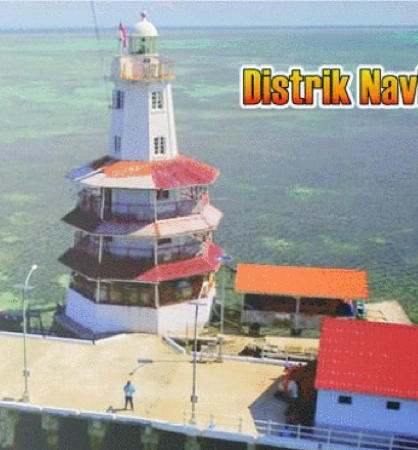
Karang Takarewataya (De Bril, Den Bril)
1887. Active; focal plane 25 m (82 ft); white flash every 10 s. 23 m (75 ft) octagonal cast iron tower with lantern and three galleries, painted white; gallery roofs painted red. The photo at right is a banner photo from the former website of the Makassar Navigation District, Joejenk Abdullah has a 2018 view, Lightphotos.net has a historic closeup photo, the Amsterdam Tropenmuseum has a 1929 distant view, and a fuzzy spot marks the lighthouse in Google's fuzzy satellite view of the reef. This is the only survivor among several lighthouses of this class built in the Dutch Indies. Located at the south end of a reef in the Flores Sea about 120 km (75 mi) south southwest of the southern point of Sulawesi. Accessible only by boat; fishing tours to the reef are available. Site status unknown. ARLHS IDO-009; Admiralty Q1524; NGA 25416.

Sabalana Islands Lighthouses
The Sabalana Islands comprise an atoll in the Java Sea far to the southwest of Sulawesi.

Pulau Banawaja (Banawawa) (2)
Date unknown (station established 1913). Active; focal plane 32 m (105 ft); two white lights every 5 s. Approx. 27 m (89 ft) "white beacon." No photo available but Google has a fuzzy satellite view. The original lighthouse had a focal plane height of 20 m (66 ft). Located on or just off a small island on the east side of the Sabalana atoll, in the middle of the Flores Sea about 150 km (90 mi) south of the southern point of Sulawesi. Accessible only by boat. Site status unknown. Admiralty Q1325; NGA 25416.5.
Pulau Jailamu (2?)
Date unknown. Active; focal plane 17 m (56 ft); white flash every 5 s. NGA describes this as a 10 m (33 ft) fiberglass tower, but two very distant views (no longer online) suggest a taller, possibly skeletal tower. No photo available but Google has a satellite view. Located on a small island at the north end of the Sabalana Islands about 210 km (130 mi) south southwest of Makassar and 65 km (40 mi) northwest of Banawaja. Accessible only by boat. Site status unknown. Admiralty Q1325.3; NGA 25416.6.
Pulau Longkoitang
Date unknown. Active; focal plane 32 m (105 ft); white flash every 5 s. Approx. 30 m (98 ft) square skeletal tower with gallery, painted white. No photo available but Bing has a satellite view. Located on a small inhabited island on the northwest side of the Sabalana atoll about 80 km (50 mi) west southwest of Pulau Jailamu. Accessible only by boat. Site status unknown. Admiralty Q1325.5; NGA 25416.7.


Karang Takarewataya Light, Java Sea
Makassar Navigation District photo

Pulau Sarege
Date unknown. Active; focal plane 13 m (43 ft); three white flashes every 15 s. 13 m (43 ft) square skeletal tower mounted on a platform supported by piles. Tower painted yellow with a black horizontal band. No photo available but Bing has a satellite view. Located off the southern tip of Pulau Serege, a small island on the south side of the Sabalana atoll. Accessible only by boat. Site open, tower closed. Admiralty Q1324.5; NGA 25586.

Sapuka Islands Lighthouses
Pulau Pelokang
Date unknown. Active; focal plane 13 m (43 ft); quick-flashing white light. 13 m (43 ft) square skeletal tower mounted on a platform supported by piles. No photo available but Bing has a satellite view. Located just off the east end of the Sapuka atoll lying between the Sabalana and Tengah Island groups. Accessible only by boat. Site open, tower closed. Admiralty Q1324; NGA 25585.
Pulau Sapuka
Date unknown (recent). Active; focal plane about 16 m (52 ft); light characteristic unknown. Approx. 14 m (46 ft) square white skeletal tower. Rahmat Hamzah has a very distant view from the sea (use zoom, tower at base of the pier), Muh Ashar also has a very distant view, and Bing has a satellite view. The lighthouse does not appear in a 2017 photo of the pier. Located near the base of the pier at Pulau Sapuka, a small island on the north side of the atoll. Site open, tower closed. Not listed by the Admiralty.

Tengah Islands Lighthouses
The Tengah Islands (Central Islands), formerly known as the Paternoster Islands, are scattered to the southwest of the Sabalana Islands; they are quite far away from Sulawesi and rather close to Sumbawa in the Lesser Sunda Islands. Nonetheless they are administered as part of the Pangkajene Dan Kepulauan Regency.
Karang Satunggul
1994. Active; focal plane 15 m (49 ft); quick-flashing white light. 15 m (49 ft) white barbell-shaped fiberglass tower mounted on a platform supported by piles. Bing has a distant satellite view. Located just off the extreme eastern tip of the Tengah atoll. Accessible only by boat. Site open, tower closed. DSI-4205; Admiralty Q1323; NGA 25584.5.
Pulau Saujung
Date unknown. Active; focal plane 14 m (46 ft); white flash every 5 s. 12 m (39 ft) white barbell-shaped fiberglass tower mounted on a platform supported by piles. No photo available but Bing has a satellite view. Located at the northern tip of Pulau Saujung, marking the northernmost point of the Tengah Islands. Accessible only by boat. Site open, tower closed. Admiralty Q1322.5.
Pulau Kapoposangbali (Kapoposang Bali)
1996. Active (?); focal plane 34 m (112 ft); white flash every 10 s. 30 m (98 ft) white concrete tower with lantern and gallery. A photo is at right and Bing has a satellite view. In November 2016 residents were complaining that the lighthouse had been out of service for at least a year. Located on a small island of the Tengah group, far across the Java Sea, roughly 360 km (225 mi) southwest of Makassar and only 80 km (50 mi) off the north coast of Lombok in the Lesser Sunda Islands. Accessible only by boat. Site status unknown. ARLHS IDO-203; Admiralty Q1322; NGA 25578.
Gosong Sakunci
Date unknown. Active; focal plane 17 m (56 ft); white flash every 4 s. 15 m (49 ft) square skeletal tower with gallery, painted white. No photo available and the light is not seen in Bing's distant satellite view of the reef. This light marks the southwest end of the extensive reef system that extends from the Sabalana and Tengah Islands. Located on a reef about 65 km (40 mi) north of Utan, Sumbawa. Accessible only by boat. DSI-4201; Admiralty Q1303; NGA 25580.

Kaposang Bali Light, Pulau Kaposang
photo by Munjiyah Dirga Gazali for tribunpangkep.com; permission requested

Information available on lost lighthouses:

Notable faux lighthouses:

Adjoining pages: North: South Sulawesi Mainland | South: Sumbawa

Return to the Lighthouse Directory index | Ratings key

Posted December 18, 2008. Checked and revised July 28, 2023. Lighthouses: 50. Site copyright 2023 Russ Rowlett and the University of North Carolina at Chapel Hill.